Wallace’s Thorn, Dunfermline, Fife

Legendary Tree:  OS Grid Reference – NT 090 873

Archaeology & History 

This little-known tree, said to have been planted in memory of Sir William Wallace’s mother, is long gone.  The only notice I can find of it, is in the writings of Pete Chalmers (1844), who told us:

“There is a tradition that the mother of Sir William Wallace was buried in the old church-yard, on the spot where the present thorn-tree is growing, but how she came to die here history seems to be silent.  It is added that her son wished afterwards to erect a monument to her memory, but being in pursuit of, or flight from, his enemies, had not time to do so, and, as a substitute, planted a thorn-tree.”

Much of what constitutes “the old church-yard” has long been covered by the new cathedral and so the precise location of this old thorn tree will never be known, which is a pity, for as Chalmers told,

“This tree had reached an immense size, and was seemingly of great age about 60 years ago (c.1784), when it was blown down by a storm and replaced by a stem from the old tree, now advanced to a considerable height and magnitude—the only living and remaining memorial of the filial affection of the Scottish Patriot.”

Due to a lack of writings from the viewpoint of Wallace and the Scottish people, we are only left with fragments regarding the why’s and wherefores of Wallace and his mum being in Dunfermline.  Chalmers thought,

“Possibly the occasion of their being here is referred to in the following lines of the poet, an account of a pretended pilgrimage of Wallace and his mother to St Margaret’s shrine.”

He then cites a more assured account of Sir William being in the area, saying:

“It is recorded of this renowned person, that, on one occasion, in 1808, when he was surrounded by his enemies, he came from the fastnesses where he had taken refuge, to the Forest of Dunfermline, and by the mediation of his friends, proposed, on certain conditions, yiz., the assurance of safety in life, limbs, sad estate, to surrender himself.  These conditions were indignantly refused by the haughty and infuriated Edward (the Tosser), who cursed him, by the fiend, for a traitor, and even set a price on his head. On hearing this, the Patriot ” betook himself again to the wilds and mountains, and subsisted on plunder.”

References:

  1. Chalmers, Peter, Historical and Statistical Account of Dunfermline, William Blackwood: Edinburgh 1844.

© Paul BennettThe Northern Antiquarian

Wallace’s Well, Dunfermline, Fife

Healing Well:  OS Grid Reference – NT 08782 87275

Also Known as:

  1. Spa Well
  2. Wallace Spa

Archaeology & History

The ruins of this little-known site, dedicated to the legendary Sir William Wallace, can still be seen in the form of an overgrown stone ruin just off the footpath that runs through the Pittencrieff Glen out of the town centre.  In earlier times the waters were evidently of some repute, as a Council meeting in May 1773 reported with some disdain the closure of the waters by a Mr Chalmers:

“This Day the Council considering that the entry from the Town to the Well of Spaw is now shut up by Mr. Chalmers, which was a particular privilege to ye Inhabitants of the Burgh, Do hereby appoint the Provost to intimate to Mr. Chalmers that the Town will not give up that privilege, and to require him to oppen an entry thereto as formerly.”

We don’t know whether the miserable Mr Chalmers gave access to the well, as there seem to be no Council meeting notes telling us the outcome.  My guess would be that the local people got their way, hopefully at Chalmers expense!  More than 70 years later, another Mr Chalmers (1844) wrote about the well in a more respectful light:

“On the north edge of the rivulet, a little below this bridge, at the foot of the Tower Hill, there is a famous well, named the Wallace Spa, or well of Spa, which was formerly much resorted to by the inhabitants of the town for its excellent water, but which has been long since disused. It is noticed here simply on account of the traditionary antiquity of its name, Sir William Wallace, it is said, having once, in the haste of a flight, drank a little of it, out of the palm of his hand.”

In spite of there being local folklore of William Wallace, the local historian Ebeneezer Henderson (1879), in his giant work on Dunfermline, thought there was a more prosaic origin to the well’s name. He told,

“This well is still in existence, about fifty yards south of the ruins of Malcolm Canmore’s Tower — Tower Hill.  The water is reported as being “very cold at all times.” The water should be analysed.  The well during the period of its being used was known as the “Spaw Well,” and the ” Well of Spaw,” and, by and by an easy, natural transition, ” Wallace Spa;” and thus the name of the well has sometime been connected with that of the great Scottish hero.”

The Well after 1900
pre-1900 image

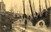
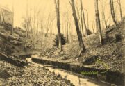
By the end of the 19th century, the well had become almost buried by earth and foliage, but was subsequently brought back to life following architectural improvements of the glen around the turn of the 20th century.  In Patrick Geddes’ (1904) work he gives us “before and after” portraits (attached here) showing how it had been restored.  He also mentioned “its tradition of medicinal value”, but could give no further information regardings the ailments it was reputed to cure…

References:

  1. Chalmers, Peter, Historical and Statistical Account of Dunfermline, William Blackwood: Edinburgh 1844.
  2. Geddes, Patrick, City Development: A Study of Parks, Gardens and Culture-Institutes, St George Press: Birmingham 1904.
  3. Henderson, Ebenezer, The Annals of Dunfermline, John Tweed: Glasgow 1879.

© Paul BennettThe Northern Antiquarian

Abbey Craig, Stirling, Stirlingshire

Hillfort:  OS Grid Reference – NS 8094 9566

Also Known as:

  1. Canmore ID 47113
  2. Wallace Monument Fort

Getting Here

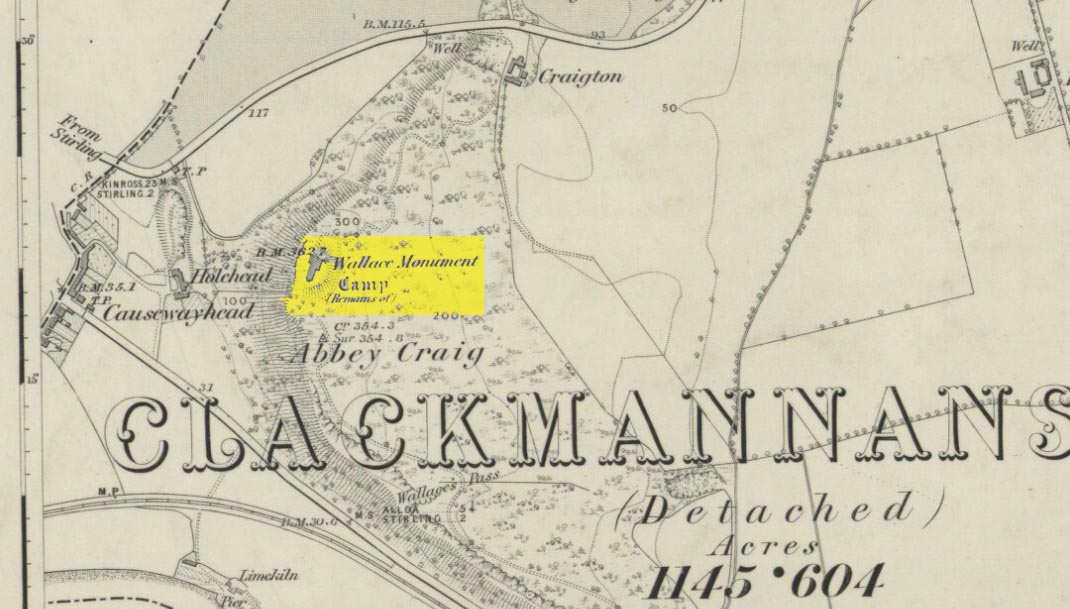
Abbey Craig on 1866 map

Most folk visiting here are coming from Stirling city.  There are various buses to get here, which head out over Stirling Bridge along Causewayhead Road (the A9) for half-a-mile where, at the roundabout and the William Wallace pub, go straight across up the minor road, zigzagging back on itself, until you reach the signs for the Wallace Monument.  Follow the well-defined footpath and, once on top of the hill, walk round the back of the mightily impressive tower.

Archaeology & History

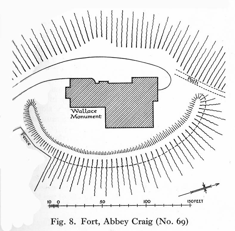
Located right where the impressive Wallace Monument proudly stands, this prehistoric precursor to Sir William Wallace’s memory was where Scotland’s legendary hero and his men cast a clear and easy view over Bannockburn, where the halfwit english came for a fight—and deservedly lost!   The structures that used to be inside the now denuded hillfort would, no doubt, have been used by Wallace’s men; but much of those prehistoric remains have now been destroyed.  The visible remains of the fort can be seen round the back of the Wallace Monument: elongated rises of overgrown walling that run almost all the way round, getting slightly higher as you approach the more northern edges, like a semi-circular enclosure.

Royal Commission plan
Abbey Craig – and the great Wallace Monument

The site was described very briefly in William Nimmo’s (1880) early survey of the area, where he told that in 1784, “eleven brazen spears were found on the Abbey Craig, by a Mr Harley”, which he thought came from the time when the earlier ‘castle’ stood here.  He was probably right.  Many years later, the prehistoric remains were included in the county survey of archaeological sites by the Royal Commission lads (1963), who told that, near the north end of the summit of Abbey Craig,

“there is a fort which has been damaged by the construction within it of the Wallace Monument.  All that remains is a substantial turf-covered bank, cresentic on plan and 260ft in length, the ends of which lie close to the brink of the precipice that forms the west face of the hill.  The bank stands to a maximum height of 5ft above the level of the interior and presumably represents a ruined timber-laced wall, since numerous pieces of vitrified stone have been found on the slopes immediately below it.

The entrance to the fort presumably lay between one end of the bank and the lip of the precipice, but both the areas concerned have been disturbed by the construction of the modern approaches.  The interior of the fort measures about 175ft from north to south, by about 125ft transversely and the interior is featureless.”

The fort was probably built sometime in the early Iron Age; so the next time you visit this fine spot, check the remains out round the back of the tower—and remember that our ancestors were living up here 2500 years ago!

References:

  1. Aitchison, N.B., “Abbey Craig Rampart’, in Discovery & Excavation, Scotland, 1981.
  2. Feacham, Richard W., Guide to Prehistoric Scotland, Batsford: London 1977.
  3. Hogg, A.H.A., British Hill-Forts: An Index, BAR: Oxford 1979.
  4. Nimmo, William, The History of Stirlingshire – volume 1 (3rd edition), T.D. Morison: London 1880.
  5. Royal Commission on the Ancient & Historical Monuments Scotland, Stirling –  volume 1, HMSO: Edinburgh 1963.
  6. Royal Commission on the Ancient & Historical Monuments of Scotland, Archaeological Sites and Monuments of Stirling District, Central Region, Society of Antiquaries of Scotland 1979.

© Paul Bennett, The Northern Antiquarian


Wallace’s Stone, Dunblane, Stirlingshire

Standing Stones / Stone Row:  OS Grid Reference – NN 83259 02293

Also Known as:

  1. Lairhill Stones

Getting Here

Follow the same directions as to reach the cup-marked Sheriffmuir Carving, which is just a coupla hundred yards away to the southwest.  On a clear day you can see this standing stone from the pub by the roadside, a few hundred yards away!

Archaeology & History

Wallace Stone (photo credit – James Elkington)

This is alleged to be just one standing stone in a straight line of five once-upright monoliths.  Starting at the southwestern end of this row we have the 7ft-long cup-marked Sheriffmuir Carved stone — which certainly looks as if it stood upright in the not-too-distant past — and as we move up the line we pass another that’s been split in half.  Another earthfast-looking rock is the next contender, before we reach our famous Wallace Stone, standing upright and proud on this moorland ridge.  It’s about 6ft tall and 3ft across at its widest and certainly acts as a marker for the line of stones that allegedly stood upright here.  And if we walk just a bit further up we have another big stone laid on the ground which is alleged to be a part of the same alignment.

The split stone (photo credit – James Elkington)

If it is an authentic megalithic row, it’s not included in either the Thoms’ (1990) two-volume work on the subject, nor Aubrey Burl’s (1996) compendium a few years later.  And though the alignment looks good, I’ve found ones just like this in the Pennines where we have just one upright left and then a line of other seemingly prostrate stones running dead straight either side of the singular upright (and have kept mi gob shut about ’em for sensible reasons), so I’m not too sure what to think.

But, alignment aside, the Wallace Stone itself is a damn good standing stone and well worth checking out.  It’s highly probable that other prehistoric remains still lurk, undiscovered, amidst these heaths…like the lost stone circle to be found nearby…

Folklore

A slight variation on a theme about this spot:  in both accounts the stone was named after the legendary Scottish independence fighter, Sir William Wallace.  The folklore tells that he and his fighting clans gathered here in 1297 preceeding the Battle of Stirling Bridge; whilst the variation tells that the stone here was actually erected around that time to commemorate the event.  This tale was first narrated by a local story-teller called Blind Harry and was found by local historian A.F. Hutchinson (1893) to be a case of mistaken identity!

References:

  1. Burl, Aubrey, From Carnac to Callanish: The Prehistoric Stone Rows and Avenues of Britain, Ireland and Brittany, Yale University Press 1993.
  2. Heggie, Douglas C., Megalithic science: ancient mathematics and astronomy in north-west Europe, Thames & Hudson: London 1981.
  3. Hutchinson, A.F., “The Standing Stones and other Rude Monuments of Stirling District,” in Transactions of the Stirling Natural History and Antiquarian Society, 1893.
  4. Royal Commission on the Ancient & Historical Monuments of Scotland, Archaeological Sites and Monuments of Stirling District, Central Region, Society of Antiquaries of Scotland 1979.
  5. Thom, A., Thom, A.S. & Burl, Aubrey, Stone Rows and Standing Stones – 2 volumes, B.A.R.: Oxford 1990.

Acknowledgements:  Big thanks as always to James Elkington for use of his photos in this site profile – prints of which are available from the man himself!

© Paul Bennett, The Northern Antiquarian


Sheriffmuir Carving, Dunblane, Stirlingshire

Cup-Marked Stone:  OS Grid Reference – NN 83074 02143

Getting Here

From Dunblane, head up the Glen Road for nearly a mile, turning left up the Sheriffmuir Road and all the wya on till you reach the pub near the T-junction another couple of miles on.  OK – get thru the gate and onto the moor, roughly in a straight line with the pub behind you for about 400 yards.  You’re damn close! (if you find the nice standing stone known as the Wallace Stone, walk  250 yards southwest from here).

Archaeology & History

Almost nothing has been written of this cup-marked stone, found at the southern end of what’s alleged to be an authentic megalithic stone row alignment, running northeast to southwest — although this alignment isn’t included in either Aubrey Burl’s (1993) or Alexander Thom’s (1990) textbooks dealing with such matters.

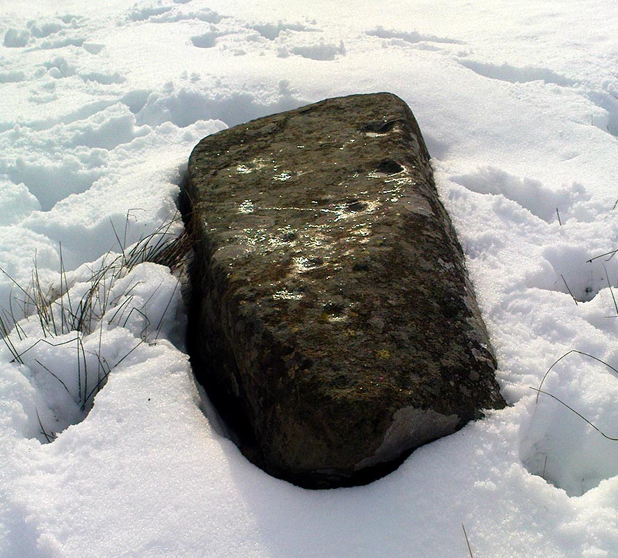
Cup-marks highlighted in ice!
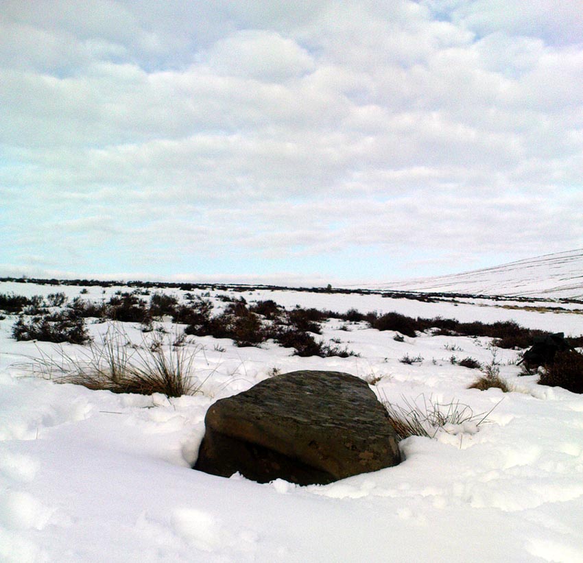
Cup-marked rock with the Wallace Stone in the distance

When we came here last winter in temperatures of around -6°C (one helluva good day!), curiously only this and the other stones along this “stone row” were actually uncovered on the moorland.  Quite bizarre to be honest!  Many of the other rocks scattering this small moorland edge were covered in several feet of snow.  We were lucky I s’ppose…though I’ve gotta get back up here again shortly and see the site in summertime (midges up mi crotch, cleggs-a-biting – oh such joy!) cos I can’t believe this is the only cup-marked stone hereby.

The rock itself is more than seven-feet long and has at least twenty archetypal cups carved into its slightly-slanting face — although when we visited the stone, several of these were difficult to see and, as the images show, even more difficult to photograph (of the 20 I took of this stone alone, only one was of any value in highlight the cups) .  The stone gave the impression that it may have stood upright in the not-too-distant past — which would of course give the notion of this as part of megalithic avenue a considerably more potent status.

Some dood alleged that this potential stone row, with this cup-marked stone at its southwestern end, marked an astronomical alignment — but for the life of me I can’t remember who it was! (it’s my age creeping up on me at last!)

References:

  1. Burl, Aubrey, From Carnac to Callanish: The Prehistoric Stone Rows and Avenues of Britain, Ireland and Brittany, Yale University Press 1993.
  2. Heggie, Douglas C., Megalithic science: ancient mathematics and astronomy in north-west Europe, Thames & Hudson: London 1981.
  3. Thom, A., Thom, A.S. & Burl, Aubrey, Stone Rows and Standing Stones – 2 volumes, B.A.R.: Oxford 1990.

© Paul Bennett, The Northern Antiquarian