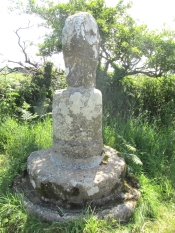
St. Sennen’s Well, Sennen Cove, Cornwall

Holy Well (lost):  OS Grid reference – SW 3550 2626

Archaeology & History

The springs of Chapel Idne

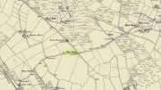
Highlighted on the 1888 Ordnance Survey map of Sennen Cove are the remains of Chapel Idne, just above the coast.  Across the road from the chapel on its south-side, and also next to an old inn to its immediate west, springs of water are shown and it would seem more than likely that one of these two would have been the forgotten holy well of Sennen that was described, albeit briefly, in the great Mr Blight’s (1861) literary tour of the area.  He told us that:

“At Sennen Cove was an ancient chapel, called by the people Chapel Idne, the “narrow chapel” being forty-five feet long and fifteen feet wide.  It is now converted into a dwelling. Tradition says it was founded by one Lord of Goonhilly, who possessed dome portion of the land of Lyonesse.  There was a holy well of some repute here also.”

The waters of St. Sennen’s Well were used in an act of ceremonial magick in the Arthurian tale known as the Battle of Vellan-druchar, as told in Robert Hunt’s (1865) great Romances.  An attempted invasion by the Danes was met with by Arthur and nine other kings and the foreigners were slaughtered.

“A few had been left in charge of the ships, and as soon as they learned the fate of their brethren, they hastened to escape, hoping to return to their own northern land. A holy woman, whose name has not been preserved to us, “brought home a west wind” by emptying the Holy Well against the hill, and sweeping the church from the door to the altar.  Thus they were prevented from escaping, and were all thrown by the force of a storm and the currents either on the rocky shore, or on the sands, where they were left high and dry.  It happened on the occasion of an extraordinary spring-tide, which was yet increased by the wind, so that the ships lay high up on the rocks, or on the sands; and for years the birds built their nests in the masts and rigging.

Thus perished the last army of Danes who dared to land upon our western shores.

King Arthur and the nine kings pledged each other in the holy water from St Sennen’s Well, they returned thanks for their victory in St Sennen’s Chapel, and dined that day on the Table-men.

Merlin, the prophet, was amongst the host, and the feast being ended, he was seized with the prophetic afflatus, and in the hearing of all the host proclaimed–

“The northmen wild once more shall land,
And leave their bones on Escol’s sand.
The soil of Vellan-Druchar’s plain
Again shall take a sanguine stain;
And o’er the mill-wheel roll a flood
Of Danish mix’d with Cornish blood.
When thus the vanquish’d find no tomb,
Expect the dreadful day of doom.”

References:

  1. Blight, J.T., A Week at the Land’s End, Longmans Green: London 1861.
  2. Hunt, Robert, Popular Romances of the West of England, 1865.
  3. Straffon, Cheryl, “Chapel Idne and the Holy Well,” in Meym Mamvro no.34, 1997.
  4. Weatherhill, Craig, “A Guide to Holy Wells and Celebrated Springs in West Penwith,” in Meym Mamvro no.4, 1997.

Acknowledgements:  Big thanks for use of the early edition OS-map in this site profile, Reproduced with the kind permission of the National Library of Scotland

© Paul BennettThe Northern Antiquarian

Wishing Well, Bone Valley, Madron, Cornwall

Sacred Well (lost):  OS Grid reference – SW 4614 3259

Archaeology & History

It’s difficult to know what to make of this site: whether it was merely a healing well or whether it possessed greater esoteric functions.  In all likelihood it was the latter as many so-called “wishing wells” in earlier centuries possessed oracular attributes.  It’s also difficult to work out precisely where this well happened to be, as we know little about it apart from the singular reference of Quiller-Couch (1894), who told simply that,

“There was also a wishing-well in the Bone Valley; it is now only a small stream, and is not used for purposes of divination.”

Hidden spring on 1878 map
Line of wells on 1908 map

There were a number of wells along the Bone Valley road highlighted on the early OS-map, all of which may have been known to Quiller-Couch at the time, three of which appeared to have streams emerging from them back then: one just above Bosoljack (SW 4556 3319) and one below it (SW 4571 3292), each just off the roadside; but then a slightly more enticing one is hidden a little further down the lane and up the tinier lane to Higher Boskinning, in the trees on the right (east).  Shown on the first OS-map as a simple “spring”, a small stream runs from it and then into the larger Bone Valley Brook which runs towards Penzance.  The solace and quietude of this spot would seem much more favourable than the other two…. but my impressions may be wrong.  It would be good if someone could find this old place…

References:

  1. Quiller-Couch, M. & L., The Holy Wells of Cornwall, C.J. Clark: London 1894.
  2. Russell, Vivien, West Penwith Survey, Cornwall Archaeological Society 1971.

Acknowledgements:  Big thanks for use of the early edition OS-map in this site profile, Reproduced with the kind permission of the National Library of Scotland

© Paul BennettThe Northern Antiquarian

Chapel Well, Botrea, Sancreed, Cornwall

Holy Well (lost):  OS Grid reference – SW 4025 3062

Archaeology & History

Just over a mile northwest of the superb Sancreed Well, we find documentary evidence from 1778 recording the field-name of Chapel Well Close here, although there seems to be no remaining spring or well and nothing is shown on the early OS-maps.  Official records define it as a “medieval well” and speculate that it may have been associated with the nearby Boscence Chapel and possibly dedicated to St. Winwaloe.

References:

  1. Anon., The Church and Parish of Sancreed in the County of Cornwall, Brewer: Sancreed c.1960.

© Paul BennettThe Northern Antiquarian

Boskenna Cross, St Buryan, Cornwall

Wayside Cross:  OS Grid Reference – SW 42579 24266

Also Known as:

  1. Historic England Grade II Listed Building No. 1007955

Boskenna Cross on 1887 map

Getting Here

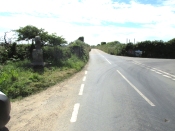
Travelling along the B3315 from Penzance to Lands End, the Cross is on the south side of the road at the junction with the minor road to St Buryan, past the Merry Maidens stone circle.

Archaeology & History

Arthur Langdon (1896), in his magnum opus on Cornish Crosses, describes this wheel-headed wayside cross:

Sketch from Langdon’s 1896 book

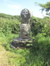
The only ancient part of the monument is the little cross at the top, which is mounted on a base made up of an extraordinary collection of apparently disused circular granite stones. Immediately beneath the cross is a cylindrical piece, the upper edge of which is roughly rounded off. Beneath this comes a short drum, about two inches wider than the piece above and nine inches deep. The next two stones are much wider but not so deep as the last, the bottom one consisting of the lower portion of an old cider-press, with its surrounding channel and lip !

Its roadside position.

There is a good deal to admire in the feeling which prompted this effort to once and for all preserve so ancient a relic, and the care bestowed in the erection of this curious substructure goes far to remove its incongruity.

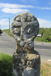
Front — The figure of our Lord here sculptured is quite the best example in which He is represented wearing the tunic; the expanded sleeves are especially apparent, as well as the outline of the garment above the knees. The feet are very large, and turn outwards at right angles.

The Crucifixion face

Back — On the head is a cross with expanded limbs, flush with the surface of the stone. The four triangular sinkings, or recesses, which form the background are not of uniform size, the lower being considerably larger than those above, thus making the lower limb the longest. The inner portion of each sinking is raised, forming bosses in low relief.

Dimensions — Total height of the monument, 6 ft. 10 in; height of the cross, 2 ft. 4 in; width of head, 1 ft. 8 in; width of shaft, 12½ in.

The cross has had a chequered history. It is not known when it was demolished.  Langdon, once more, takes up the story:

The opposite face.

Mr. J. H. Johns, landlord of the “King’s Arms”, St. Buryan, informed me of the circumstances connected with the discovery of this cross. It appears that formerly one of the angles at the intersection of these roads was so sharp and awkward for traffic that, in 1869, the local authorities decided to ease this corner by rounding off the hedge, which was then about ten feet thick. Mr. Johns’ father was one of the men employed on this work, and shortly after commencing he found the cross buried in the hedge. By the advice of His Honour Charles Dacres Bevan, County Court Judge of Cornwall, and then residing at Boskenna Mansion House, the cross was erected on the triangular piece of grass in the middle of the roads, a spot on which it is extremely likely it originally stood.

Side view from the east.

In 1941 and 1942, the Cross was demolished by road vehicles, whereupon the council removed it to its present roadside position. It was again hit by a vehicle in 1992. And in 2002 there was another incident, reported by Meyn Mamvro:

..In February the top of the cross was found lying by the roadside. It is not known whether this was the result of deliberate vandalism or a road traffic accident, but local village witch Cassandra Latham acted quickly in alerting Cornwall Archaeological Unit, who took it away for repair and restoration…

References:

  1. Langdon, Arthur G., Old Cornish Crosses, Truro, Joseph Pollard, 1896.
  2. Langdon, Andrew, Stone Crosses in West Penwith, The Federation of Old Cornwall Societies, 1997.
  3. Meyn Mamvro, No 49, Autumn 2002, p. 4

© Paul T. Hornby 2018