Riverbank Cup-Marking, Askwith, North Yorkshire

Cup-Marked Stone:  OS Grid Reference – SE 1659 4744

Getting Here

Just over the county boundary on the north side of the Wharfe’s riverbank, the easiest way to find this is from the village of Burley-in-Wharfedale, walking out as if heading towards Ilkley (west) and, just 100 yards or so before reaching the A65(T) road, walk down the footpath that takes you down to the River Wharfe.  Go over the large stepping-stones and, once on the other side, walk down the edge of the riverbank for 10 yards, up the first ridge and there, just below the grass where the edge of the land is coming away, you’ll find this small cup-marking.

Archaeology & History

First discovered t’other day, on Friday, 28 May, 2010, when we were starting on another wander onto the hills.  We’d only just crossed the large stepping-stones over the River Wharfe just outside Burley and heading up to Askwith, when Michala Potts stopped, peered and said summat along the lines of, “Errr….look at this!”
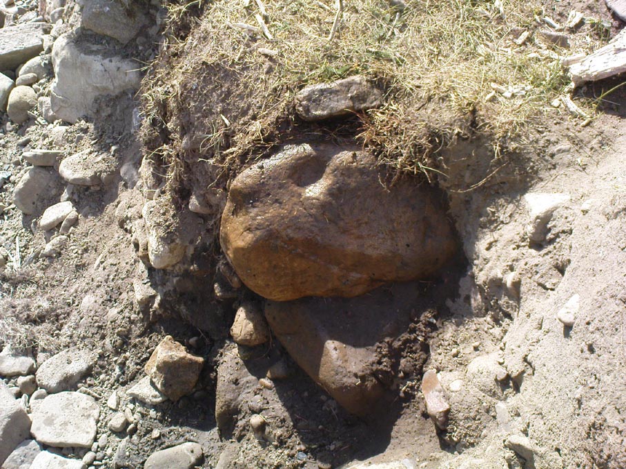
Riverbank Cup-Marking
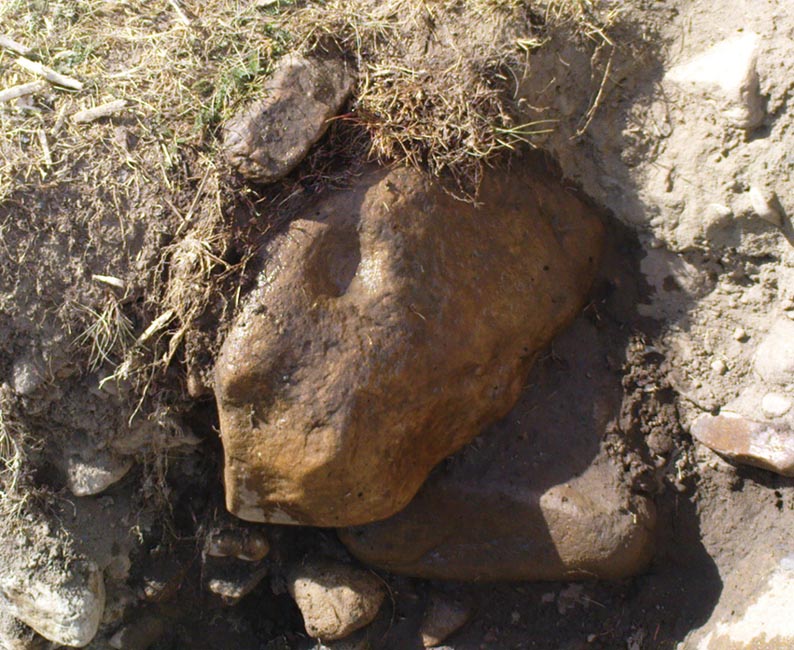
Close-up of cup-mark

My initial thought was it was gonna be some naturally eroded water-worn stone — but it didn’t seem that way.  Peering out from the edge of the ground n the company of many other small stones and gravel, which was slowly coming away just yards above the edge of the river, a rounded cup-marked stone with just a single cup-mark stood out like a sore thumb!  It was covered in dusty earth and looked a quite decent example; but once we’d cleared the dried earth away and wet the stone, the cup-marking was truly enhanced.  To those of you who have a thing about cup-markings and associations with rivers and streams, this one can be added to your statistics! (20 yards away the Askwith East Beck meets with the river)

Obviously added as part of the river embankment, the stone would obviously have been taken from a nearby source, but we’re unlikely to ever find out where.  It looks typical of cup-marked stones that were added to cairns, but no such site (that we know of) occurred close by.  We were gonna peel some of the embankment back and see if there was anything else here, but time and another ancient site that we’d arranged to see was calling us away, so we just got a few pictures and kept on our way…

© Paul Bennett, The Northern Antiquarian

St. Alban’s Well, St. Albans, Hertfordshire

Holy Well:  OS Grid Reference – TL 146 066

Also Known as:

  1. Holy Well of St. Albans

Archaeology & History

The ancient and once sacred water source was described in local place-names such as Holywell strete and Holywellbrugge from the 13th Century onwards; yet despite it being at the heart of one of the cradles of the English church, there are only scant accounts of the legendary well down the centuries.  The most detailed essay on this site was written by Tony Haynes (1986) in the specialist holy well journal, Source, more than 20 years ago.  Haynes tells as much as it known of the site, saying:

“Late in the seventeenth century, when John Churchill, future Duke of Marlborough, pulled down his wife’s house and built a new mansion in the middle of Holywell Hill, thus creating a major diversion, the Holy Well was a feature of his terraced gardens.  Maps of the period show the site of the well to be a focal point of his lawns.

“In 1815, Shaw’s guide to the town states, ‘The holy-well is still held in some esteem for its purity and salubrious qualities’.  The Duke’s residence later became the property of the Earl Spencers. It eventually fell into ruin and was demolished in 1837, and the original route of Holywell Hill was restored, no doubt much to the relief of contemporary coach and wagon drivers. After this time, the grounds were left to decay.  Ten years later little remained of the gardens but a fishpond and the Duke’s ‘canal’ marking the original course of the River Ver.

“Of the Holy Well, in his History of St Albans published in 1893, Charles Ashdowne laments that: “It is now remembered only as a muddy depression, sheltered by the remains of a dilapidated wall and a mournful specimen of blackthorn.”  Eventually the land was acquired by the St Albans School for Boys as a playing field.  “The exigencies of athleticism necessitated the ground being levelled and turfed over,” Ashdown continues, “and it is much regretted that there is nothing to mark the site of what was essentially one of the most ancient of English Holy Wells.”

“This is confirmed by a Miss Lightfoot of Holywell Hill. In 1960, when she was 85, she wrote in a letter to Hertfordshire Countryside magazine:  ‘I remember the well quite well, for as a child I often went round it. It was surrounded by a fence, inside was a tree, water and weeds – not very inviting.’

“The ‘Old boys’ of St Albans School recall, about fifty years ago, there being a concrete slab at one end of their football pitch which they knew as the site of the well. Their playing field fell into disuse in the 1960’s, but the exact site of the well was lost long before this.”

Naff all is visible here nowadays, apart from some concrete square bitta brickwork that betrays any sense whatsoever of a once sacred site.  Very disappointing indeed…..

Folklore

As with a great many British holy wells, this all-but-forgotten site was named after one of the early christian martyrs — in this case from as early as the late 3rd century AD.  A number of early folklore texts describe St. Albans story, with Vernon Brelsford (1958) telling:

“Tradition states that on his way to execution he walked up a neighbouring hill where he prayed for water to quench his thirst, whereupon a fountain of water sprang up under his feet.  Here he was beheaded on June 23, AD 303.”

This date indicates the site probably replaced an earlier, heathen midsummer solstice custom at, or near this spot.  Another tale tells that when St. Alban had been executed, the saint’s head rolled down the hill and into the waters of the well below.  Mr Haynes (1986) described other early folklore which seems to relate to St. Alban’s Well, telling:

“An early reference to the well can be found in the writings of Brompton who lived in the time of Richard II. He recorded that the father of King Arthur, a British Prince, was severely wounded in the battles with the Saxons:

‘A long time he lay confined to his bed until at length he was cured by resorting to a well or spring not far distant from the city. at that time reputed to be salubrious; and for that reason, and for the cures thereby performed, esteemed holy; and blessed in a peculiar manner with the flavour of Heaven.’

“Two devout sisters built a shelter near the well. They served the weary pilgrims who trudged up the steep hill towards Alban’s shrine in the abbey, by dipping, or ‘sopping’ their bread in the holy water and offering it to the thirsty travellers.  Hence was founded Sopwell Priory, nearby.”

References:

  1. Brelsford, Vernon, Superstitious Survivals, Centaur Press: London 1958.
  2. Gover, J.E.B., et al, The Place-Names of Hertfordshire, Cambridge University Press 1938.
  3. Haynes, Tony, “Well-Wishing in St. Albans,” in Source, no.6, 1986.
  4. Hope, R.C., The Legendary Lore of the Holy Wells of England, Elliot Stock: London 1893.

© Paul Bennett, The Northern Antiquarian

St. Patrick’s Well, Heysham, Lancashire

Holy Well:  OS Grid Reference – SD 4109 6159

Getting Here

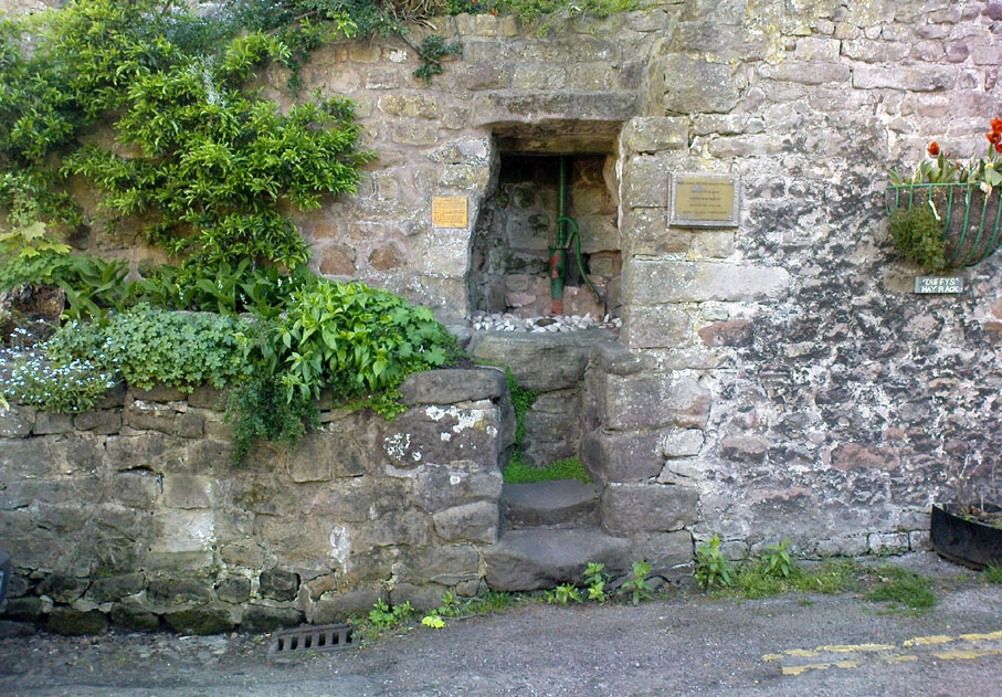
From Heysham village centre by the little roundabout, go down the gorgeous olde-worlde Main Street for about 150 yards, keeping your eyes peeled for the little track up to the tree-lined church of St. Peter.  Just before going up the path to the church, set back at the roadside, you’ll see an old pump in an arch in the walling.  That’s St. Patrick’s Well!

St.Patrick’s Well, Heysham

Archaeology & History

Not to be confused with another St. Patrick’s Well a few miles north of here, little has been said of this old holy well in literary tomes (even Henry Taylor’s (1906) magnum opus missed it!)  Sadly the waters here have long since been diverted (which violates religious tradition, quite frankly), and all we see today is an old iron water-pump set inside a stone arch, beneath which – I presume – the waters once ran.  An old plaque on the site of this ancient well tells:

“This is one of two holy wells in Heysham village (the other, Sainty Well, is on private property and covered over), whose dedications are long since lost.  Latterly the water from this well was used for utilitarian gardening purposes within the confines of the old rectory.

“Previously the well had fallen into disuse, suffered from surface contamination and became rubble-filled when the bank above gave way in the mid-1800s.  In the early 1900s, the well-head was again rebuilt and the well itself was cleaned and made safe by capping with concrete.  Recently (May 2002) the well-head has been refurbished and water artificially introduced, thus turning a derelict area into a feature of the village.”

It would be good if local people could complain to the regional water authority and make them redirect the waters beneath the well, back to the surface, to allow devotees — both Christian and otherwise — to partake of the holy blood sanctified by St. Patrick many centuries ago.  And without fluoride or other unholy chemical compounds that desecrate our waters.  Just the sacred waters of God’s Earth please!

Folklore

This is one of the many places in the British Isles where St. Patrick was said to have landed after he’d converted all the Irish into the christian cult!  One of the traditions was that St. Patrick said the well would never run dry — which was shown to be untrue when the waters were filled in with rubble in the 19th century.  The same saint also used the waters from the well to baptise and convert the peasants of his time.

References:

  1. Quick, R.C., Morecambe and Heysham, Past and Present, Morecambe Times 1962.

© Paul Bennett, The Northern Antiquarian

Tobar na Cailleach, Keith, Banffshire

Sacred Well:  OS Grid Reference – NJ 42659 47528 

Also Known as:

  1. Cailleach Well 
  2. Tobar Chailleach 
  3. Well of the Cailleach

Folklore

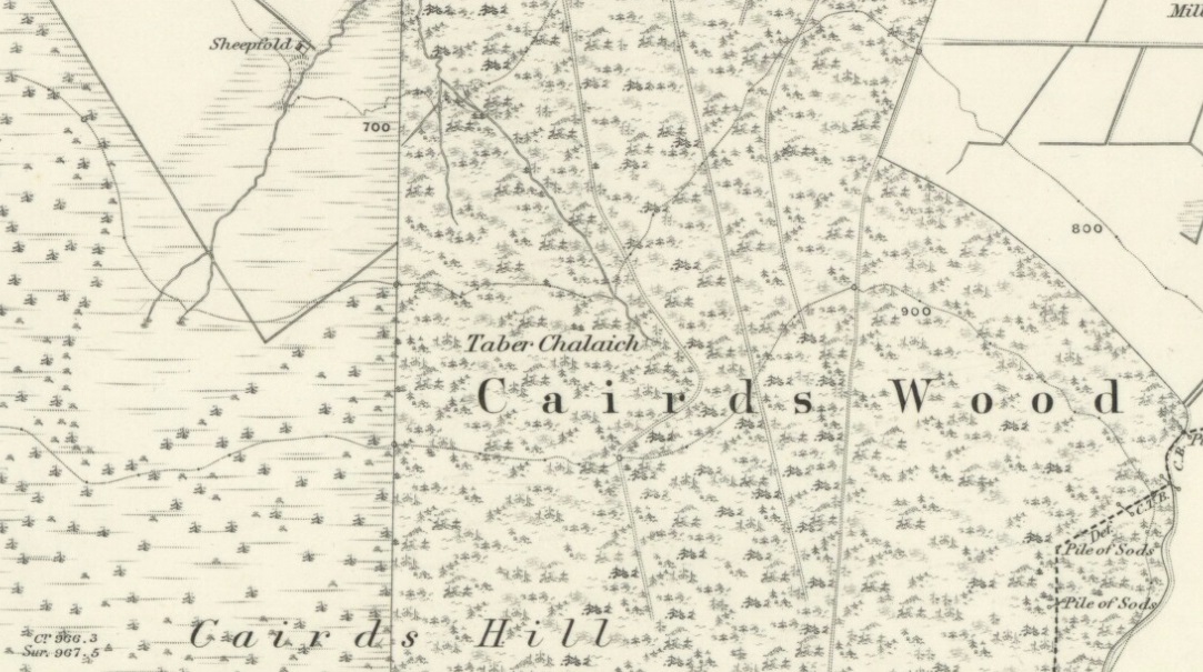
Cailleach Well on 1869 map

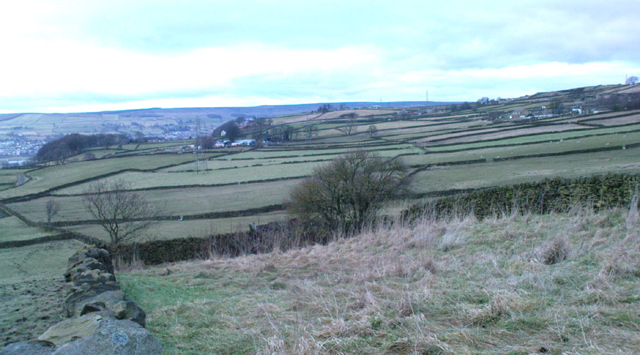
Described on the earliest OS-map of the region as Taber Chalaich, this great “well of the old woman, or hag” is found on the northern slopes of Cairds Hill, amidst increasingly dense woodland up the top of the stream which ebbs and flows in strength (depending on the weather).  A water source dedicated the prima mater Herself — i.e., the heathen pre-Celtic female creation deity par excellence — it was once of considerable repute locally as being a great curing well and was described by Ruth and Frank Morris (1981) as being,

“the scene of a pagan ceremony in which the Earth Mother in her old woman phase bathed at the well and returned as a young maiden.”

On the hill at the top we find remains of old tombs (mistakenly ascribed by Mr & Mrs Morris as ‘stone circles’), some of which may have had some mythic relationship with this legendary water source.  Further information and/or any photos of this little-known site would be hugely welcomed!

References:

  1. Morris, Ruth & Frank, Scottish Healing Wells, Alethea Press: Sandy 1982.

© Paul Bennett, The Northern Antiquarian

St. Margaret’s Well, Binsey, Oxford, Oxfordshire

Holy Well:  OS Grid Reference – SP 486 080

Archaeology & History

A sacred water source that is thought to have taken its name from the adjacent church of St. Margaret (makes sense!).  The site was described at some length in the fine work of Robert Charles Hope (1893), where he quoted extensively from earlier works:

At the west end of this chappel, about three yards distant, is the well or spring, antiently and to this day called St. Margaret’s Well, being the very same that she by her prayers at the building of the chapple opened. Of which heare a certaine old English poet, who in the life of St. Frideswyde in the legend of English saints, speaking of her various fortunes and of her passage from Bampton to this place, saith thus:

Ther fer with her [fellows.] she be laft ther
And to serve Jhesu Christ . a chapel leet [raise.]
Ther as is yit a fayr cort . and a cherche fayr and swete
Arerid in the honour . of her and Seynte Margrete
As this mayde [lived.] ther . in holy lyf and clene
The maydenes that were with her . gone hem ofte be [bemoan.]
That water was sum del to fer . hem ofte for smale dede
And cride on Seynt Friswid . that she schold hem therof [rid]
This mayde Seynt Friswid . bad our lordis sonde
That he water thorw his gras . hem sente ner honde
So sprong ther up a welle . cler [enough] and clene
That fond hem water inowf . tho dorst hem nought be mene
That beside the cherche is [it] . in the west syde
That mony a mon hath bote do . and that men seggeth wide.

Over St. Margaret’s Well was a covering of stone, and thereon on the front the picture of St. Margaret (or perhaps St. Frideswyde), pulled down by Alderman Sayre, of Oxon, a little before the late war, 1639.

To this well also and her image and certaine reliques in the chapple did the people come on pilgrimage with as great devotion to ease their burdened soules and obtaine resolutions of their doubts, as they would to an oracle.

And here, also, when those maimed and unsound folke had bin cured either by bathing in, or drinking of; this water, hang up their crutches as a speciall memorandum of their cured griefs. For which end and purpose there were severall preists that inhabited here appointed by the Prior of St. Frideswide’s purposely to confess and absolve those pilgrims.

Near to this place it was that the Lady Edyne, of Wynton, the widdow of Sir William Lancelot, knight, had a vision. (See Twyne, xxi., 199.)

The well wee find almost to the last frequented by superstitious people, and especially about a hundred years before the dissolution.  Soe much, that they were forced to enclose it–as in old time before, they had defended it–with a little house of stone over it with a lock and a dore to it. But all decaying and going much to ruine, at the suppression of St. Frideswyde’s Priory, was at last –I meane the little house–about twenty-five years agoe, pulled downe and quite taken away. Soe that now being overgrowne with nettles and other weeds, and harbouring frogs, snails, and vermin, scarce owneth the name of a well; noe more than the old and small building joyning to the north side of the chapple doth–as formally it did–a court.

The well is now in better condition. When I visited it on 25th October, 1887, the churchyard was tidily fenced and very neatly kept. At the well a descent of some five steps brought one to an arched vault, beneath which, in the centre of the flooring, was a round basin containing the water of the well, the surface of the water being about six feet below the level of the ground.  On the wall above the arch was this inscription:

“S. MARGARET’S WELL.

S. Margaretae fontem, precibus S. Frideswidæ (ut fertur) concessum, nquinatum diu obrutumque in usum revocavit T. J. Prout, Aed. Xti alumnus, Vicarius, A. S. MDCCCLXXIV.

At the time of the restoration of this well, an Oxford wit, having regard to its proximity to the church, suggested for an inscription:

Ariston men hydor
When you open your pew-door,
This may comfort supply
Should the sermon be dry.

(Ibid., pp. 323-328, et seq.)

Denham Tracts, p. 151: The well of St. Margaret or St. Frideswide, in Binsey churchyard, scarce two miles from Oxford, is supposed to have sprung from the prayers of St. Frideswide, and many in olden times consulted it as an oracle on the state of their burdened souls; maimed and sick persons drank and bathed in the waters, and were cured by them. The stone edifice was in the last century destroyed, but has been restored.

References:

  1. Hope, R.C., The Legendary Lore of the Holy Wells of England, Elliot Stock: London 1893.

© Paul Bennett, The Northern Antiquarian 

St. Agnes’ Well, Cothelstone, Somerset

Holy Well:  OS Grid Reference – ST 183 318

Folklore

In this lovely little hamlet we find an ancient well, registered as a scheduled monument in its well-house, but with a long history and lots of legends. It was said to have been a wishing well of considerable power, but many local people wouldn’t use it because it was also the place where mischievous pixies lived. It seems that one of its main magical properties was to divine the love of a person. The writer Ruth Tongue (1965) told a long tale she came across in her county folklore book about such a fortune:

“There was a maid servant, see, and she were coming on in years and she do serve a farmer’s wife as were high in station. Proper tackalackey she made of the dear soul, and she having no living kin. Twas pitiful, and her a-longing for a parcel of children underfoot, even if ’twas only to call her Auntie. But there, ‘twadn’t to be, and her with a heart so full a-drip with loving kindness as a honey comb. Oh, she were a proper mannerly maiden, no ways like her mistress who were just a old ewe dressed up lambs fashion and spending her days living two-three steps from nothing. But it didn’t seem like the maiden couldn’t never meet up with a proper man for her. She wadn’t no summer morning to look at, poor soul, and her mistress kept her so thin as a yard of pump water. But there Providence knows best! There were a old fellow over by Aisholt, and he were such a upstanding courageous man he’d a never got round to marrying, let alone finding the bravery to walk arm in crook with a maiden. Well o’ course he were lonely like she. And it come to a St. Agnes Eve when maids creepy over to her well at Cothelstone and whisper their heart’s desire when ’tis dark, and if St. Agnes do fancy the maiden she’ll send a husband that year. Now the poor maid she were coming to the end of her days of womanhood and beginning to blossom about the head, and she were desperate unhappy about it. Her heart was all a-set on children, and she find bravery to slip out after farm’s a-locked up. She didn’t feel ’twere mannerly to worrit St. Agnes over one who was so on in years when there was young maidens as plentiful as blackberries, so what do the dear soul do but go down all in the dimmit to the Wishing Well in Seven Wells Coombe. Proper unket well ’tis, and hard tew find. But St. Agnes must ha’ knowed, for she found’n though there wadn’ but little moon and old fellow he d’hear summat down in coombe and come to look-see. He were a wise old man and nothing hurted he, but he were shy of folks, seems like. Well, whether ’twere St. Agnes I can’t say, but in a year the farm was sold up and the maid was a-wed to the old fellow. So quiet as a sheep the man was, wouldn’ downarg no-one, but he made her a good husband. In a year or two she’d a babe in the cradle and one under her apron, and two clinging to her skirts, and they was all so happy as daisies in the sunshine, as they say.”

References:

  1. Tongue, Ruth, Somerset Folklore,FLS: London 1965.

© Paul Bennett, The Northern Antiquarian


Tobar Mor, Tarbert, Gigha, Argyll

Sacred Well:  OS Grid Reference – NR 6564 5190

Also Known as:

  1. Canmore ID 38609
  2. Great Well of the Winds
  3. St Beathag’s Well
  4. Tobar Bheathaig

Folklore

There are a number of sacred and healing wells on this small island, but this site in particular was deemed magickal by folk from far and wide.  Found on the northwest slopes of Cnoc Largie (around which are other heathen spots) this legendary site had an attendant keeper of the well:

“an aged female direach, or guardian, whose uncanny powers could be commanded by a small offering of silver.  Following this the cover of the sacred well would be removed in order that its waters might be ceremonially cleansed with a white clamshell prior to being stirred three times, sunwise, to the accompaniment of ritual incantations.  Then three shell-fulls of the sacred water would be hurled aloft in the direction of the desired wind which, before the day was out, invariably appeared.”

This simple ritual obviously tells that it was a heathen site, seemingly one for divination and magick.  Another piece of folklore (found at other wells) told that if the cover on the well were left unattended, its waters could overflow and flood the entire island.

References:

  1. Anonymous, Exploring Historic Kintyre and the Isle of Gigha, Harlequin Press: Oban n.d.

© Paul Bennett, The Northern Antiquarian

Goff Well, Keighley, West Yorkshire

Healing Well:  OS Grid Reference – SE 06149 38822

Getting Here

Goff Well is by the Elder tree in the middle

Various ways here. From Keighley, go up the A629 Halifax Road, first left after the Ingrow West train station, uphill; then turn right, and up the long, cobbled, zizaggy road past the little hamlet of Hainworth and uphill till you reach the solitary farmhouse of Goff Well Farm (where its friendly owners can sell you organic fresh eggs!).  It’s the field just before here on your left (if you reach the Guide Inn pub further uphill by the crossroads, you’ve gone too far). Alternatively start at the Guide Inn pub and walk across the road and downhill till you reach the farm. It’s in the first field on the right just past it.

Archaeology & History

Little is known about the history of this water source.  The first description of it seems to be in 1852.  Harry Speight (1898) mentions it briefly when he talks about the holy wells of the locale, saying simply:

“Goff Well, close to the road on Harden Moor leading to Hainworth, has given name to a neighbouring farm, but the purpose or virtues of this water are not now known.”

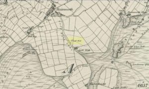
Goff Well on 1852 OS-map

Today the well is much overgrown and in need of attention.  It’s near the bottom corner of the field where the larger of the elder tree grows (the witch’s tree par excellence) and could do with being cleaned out.  When the owner of Goff Well Farm, Barry, took us to see the site, the waters couldn’t be seen but we could hear the water running clearly just beneath the surface, so it just needs a few hours work to bring it back into life.  Twouldst do the land and the genius loci the world of good!

The very name of the well is something of an anomaly.  There are several possibilities and we (as yet) cannot say which is the more likely derivation.  We know in northern dialect that Goff is a simpleton or fool, and although we can apply that definition in some cases, it’s unlikely to apply here.  If we could ascertain there was ever an apple tree growing here, the mystery would be solved, as a goff was an old word used for the common apple.  In West Yorkshire dialect the word was also used to denote “a hammer worked by water-power”; aswell as it being a corrupted form of the word ‘God.’  Take your pick!

Folklore

The early Victorian historian William Keighley (1858) thought Goff Well was named after a long-forgotten hermit called Goff who, at some time in the past, gave his name to the old hamlet of Hermit Hole, a half-mile downhill from this water source.  Mr Keighley wrote:

“On the skirts of Harden Moor is a farmhouse known by the name of Goff Well; and as goff is said to be the Danish word for red, it would probably be no great stretch of the imagination to suppose that the hermit was so named on account of his red hair, and the spring or well designated after him from the frequency and sanctimonious nature of his visits.”

But this is pure supposition on Keighley’s part — nice idea though it is!  The only tangible piece of folklore we have is that the well “was a famous resort of gypsies before the moor was enclosed in 1861.” (Speight 1898)

References:

  1. Keighley, William, Keighley, Past and Present, Arthur Hall: London 1858.
  2. Speight, Harry, Chronicles and Stories of Old Bingley, Elliott Stock: London 1898.

© Paul Bennett, The Northern Antiquarian


Lee Hall Well, Bellingham, Northumberland

Healing Well:  OS Grid Reference – NY 861 797

Archaeology & History

Very little is known about this forgotten heathen water source.  It was described in some notes attached on a piece of paper accompanying John Warburton’s description of Lee Hall and its surroundings.  The notes were first printed in an early edition of Archaeologia Aeliana and subsquently included in Binnall & Dodds’ (1942) fine survey on the holy wells of the region.  It’s exact whereabouts appears to be lost, and may be either the small pool across from the present Hall, or a small spring found in the edge of the small copse of trees just east of Lee Hall Farm. Anyone know for sure?

Folklore

Written verbatim in that dyslexic olde english beloved of old folklorists like misself, the only bitta folklore said of this spring of water told:

“At the Lee hall an exclent spring, the vertue is such that if the lady of the Hall dip aney children that have the rickets or any other groone destemper, it is either a speedy cure of death.  The maner and form is as followeth: The days of dipping are on Whitsunday Even, on Midsumer Even, on Saint Peeter’s Even.  They must bee dipt in the well before the sun rise and in the River Tine after the sun bee sett: then the shift taken from the child and thrown into the river and if it swim…child liveth, but if it sink dyeth.”

The latter sentence echoing the crazy folklore of the christians to identify witches in bygone days!

References:

  1. Binnall, P.B.G. & Dodds, M. Hope, ‘Holy Wells in Northumberland and Durham,’ in Proceedings of the Society of Antiquaries of Newcastle-upon-Tyne (4th Series), 10:1, July 1942.

© Paul Bennett, The Northern Antiquarian


Spring Stone Carving, Middleton Moor, North Yorkshire

Cup-Marked Stone:  OS Grid Reference – SE 11611 51610

Also Known as:

  1. Middleton Moor carving 483 (Boughey & Vickerman)

Getting Here

From Ilkley go up to Middleton and from there go up Harding Lane and, where the road bends left a track goes straight north onto the moors. Go up this until you’re onto the moor proper. Keep going until you’re following the line of walling, where a small stream is trickling right by your right-hand side. Follow this to its source a coupla hundred yards up. Stop!

Archaeology & History

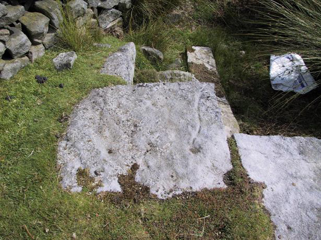
Middleton Moor CR483: single cup-and-line

First mentioned by Stuart Feather in 1965, this simple cup-marking has a long line squirming away to the edge of the rock on which it’s carved.  The cup-marking is some 3 inches across and about ½-inch deep, with the long line about 24 inches long.  There’s really nowt much to look at here unless you’re a real cup-and-ring freak — though note that the carving occurs on a broken piece of stone just where a spring of water emerges from the ground.  Some archaeo’s have a notion that sometimes our cup-and-ring stones have some sorta relationship with water — though they’re not into sticking their necks out and saying anymore than that!  And of course, some carvings obviously relate to water. This one here is a strong contender, with the long wiggly line perhaps representative of the stream running from its source, which itself is the cup-mark.

However, we might just aswell surmise that the carving here was executed by some bored teenager, just testing out his first antler pick, or flintstone, telling his mates, “I woz ‘ere!”

References:

  1. Boughey, Keith & Vickerman, E.A., Prehistoric Rock Art of the West Riding, WYAS 2003.
  2. ather, Stuart, ‘Cup and Ring Boulders,’ in the Cartwright Hall Archaeology group Bulletin, 10:7, July 1965.

© Paul Bennett, The Northern Antiquarian