St. Sennen’s Well, Sennen Cove, Cornwall

Holy Well (lost):  OS Grid reference – SW 3550 2626

Archaeology & History

The springs of Chapel Idne

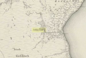
Highlighted on the 1888 Ordnance Survey map of Sennen Cove are the remains of Chapel Idne, just above the coast.  Across the road from the chapel on its south-side, and also next to an old inn to its immediate west, springs of water are shown and it would seem more than likely that one of these two would have been the forgotten holy well of Sennen that was described, albeit briefly, in the great Mr Blight’s (1861) literary tour of the area.  He told us that:

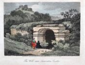
“At Sennen Cove was an ancient chapel, called by the people Chapel Idne, the “narrow chapel” being forty-five feet long and fifteen feet wide.  It is now converted into a dwelling. Tradition says it was founded by one Lord of Goonhilly, who possessed dome portion of the land of Lyonesse.  There was a holy well of some repute here also.”

The waters of St. Sennen’s Well were used in an act of ceremonial magick in the Arthurian tale known as the Battle of Vellan-druchar, as told in Robert Hunt’s (1865) great Romances.  An attempted invasion by the Danes was met with by Arthur and nine other kings and the foreigners were slaughtered.

“A few had been left in charge of the ships, and as soon as they learned the fate of their brethren, they hastened to escape, hoping to return to their own northern land. A holy woman, whose name has not been preserved to us, “brought home a west wind” by emptying the Holy Well against the hill, and sweeping the church from the door to the altar.  Thus they were prevented from escaping, and were all thrown by the force of a storm and the currents either on the rocky shore, or on the sands, where they were left high and dry.  It happened on the occasion of an extraordinary spring-tide, which was yet increased by the wind, so that the ships lay high up on the rocks, or on the sands; and for years the birds built their nests in the masts and rigging.

Thus perished the last army of Danes who dared to land upon our western shores.

King Arthur and the nine kings pledged each other in the holy water from St Sennen’s Well, they returned thanks for their victory in St Sennen’s Chapel, and dined that day on the Table-men.

Merlin, the prophet, was amongst the host, and the feast being ended, he was seized with the prophetic afflatus, and in the hearing of all the host proclaimed–

“The northmen wild once more shall land,
And leave their bones on Escol’s sand.
The soil of Vellan-Druchar’s plain
Again shall take a sanguine stain;
And o’er the mill-wheel roll a flood
Of Danish mix’d with Cornish blood.
When thus the vanquish’d find no tomb,
Expect the dreadful day of doom.”

References:

  1. Blight, J.T., A Week at the Land’s End, Longmans Green: London 1861.
  2. Hunt, Robert, Popular Romances of the West of England, 1865.
  3. Straffon, Cheryl, “Chapel Idne and the Holy Well,” in Meym Mamvro no.34, 1997.
  4. Weatherhill, Craig, “A Guide to Holy Wells and Celebrated Springs in West Penwith,” in Meym Mamvro no.4, 1997.

Acknowledgements:  Big thanks for use of the early edition OS-map in this site profile, Reproduced with the kind permission of the National Library of Scotland

© Paul BennettThe Northern Antiquarian

Maiden’s Well, Launceston, Cornwall

Holy Well (destroyed):  OS Grid reference – SX 3285 8477

Archaeology & History

Site of well on 1884 map

Very little is known about this holy well on the north-western side of town that was apparently destroyed sometime in the 19th century; for when the Ordnance Survey lads visited here in 1882, they found no running water but only the location of where it had been and they indicated this on their 1884 map of the area, marked as “Site of.”

It was first mentioned in a short topographical notice in 1582, which told that the “Magden Well in the Quarrie Haye”—along with another well—was “found to be in decay.” (Peter 1885)  Then, when the Ordnance Survey lads resurveyed the area again in 1951, once more they could find no trace of it.

References:

  1. Peter, Richard, The Histories of Launceston and Dunheved, W. Brendon: Plymouth 1885.

Acknowledgements:  Big thanks for use of the early edition OS-map in this site profile, Reproduced with the kind permission of the National Library of Scotland

© Paul BennettThe Northern Antiquarian

Holy Well, Lawhitton, Cornwall

Holy Well:  OS Grid reference – SX 3546 8252

Archaeology & History

Site shown on 1882 OS-map

Highlighted on the 1882 OS-map several hundred yards north of St. Michael’s church, this site seems to have fallen back to Earth as no remains of it have been found in recent visits.  It was described in Charles Henderson’s (1914) notes as the “holy well at Barton Farm”, and was visited by J. Meyrick (1982) in April of 1980, who told that it could be found by taking “the track immediately east of Lawhitton church which runs through the farm of Mr Lancaster…  After going through the yard proceed ¼ mile down track to the valley where you reach a stream and the Well is on the right.”  It was sought after by Cheryl Straffon (1998) but following her visit to find the Well she told that “there was nothing now to see except a kind of natural basin by the small bridge.”

References:

  1. Henderson, Charles, Notebooks of Parochial Antiquities, Unpublished MS 1914.
  2. Meyrick, J., A Pilgrims Guide to the Holy Wells of Cornwall, Falmouth 1982.
  3. Straffon, Cheryl, Fentynyow Kernow: In Search of Cornwall’s Holy Wells, Meyn Mamvro: Penzance 1998.

Acknowledgements:  Big thanks for use of the early edition OS-map in this site profile, Reproduced with the kind permission of the National Library of Scotland

© Paul BennettThe Northern Antiquarian

Holy Well, Trelawne, Cornwall

Holy Well (lost?):  OS Grid reference – SX 2258 5311

Archaeology & History

This spot is where an old field-name has preserved the memory of an all-but-forgotten holy well, known as the “Holywell Ground.”  Although it may have fallen back to Earth, there are two possible spots regarding its position: i) a spring that was marked on the 1882 OS-map at SX 2258 5315, and ii) a “Well” that’s shown on the recent OS-maps (SX 2257 5306).  Hence, the grid-reference I’ve given to this place is the halfway spot between them both. (it has to be pointed out that the “well” on recent maps occurs right next to an old quarry, which are well known to bring forth water sources that were previously deep underground)  Whether or not Sclerder Abbey—about 400 yards west of here and only built in 1843—had anything to do with the sanctifying this well, I do not know.

© Paul BennettThe Northern Antiquarian

Wishing Well, Bone Valley, Madron, Cornwall

Sacred Well (lost):  OS Grid reference – SW 4614 3259

Archaeology & History

It’s difficult to know what to make of this site: whether it was merely a healing well or whether it possessed greater esoteric functions.  In all likelihood it was the latter as many so-called “wishing wells” in earlier centuries possessed oracular attributes.  It’s also difficult to work out precisely where this well happened to be, as we know little about it apart from the singular reference of Quiller-Couch (1894), who told simply that,

“There was also a wishing-well in the Bone Valley; it is now only a small stream, and is not used for purposes of divination.”

Hidden spring on 1878 map
Line of wells on 1908 map

There were a number of wells along the Bone Valley road highlighted on the early OS-map, all of which may have been known to Quiller-Couch at the time, three of which appeared to have streams emerging from them back then: one just above Bosoljack (SW 4556 3319) and one below it (SW 4571 3292), each just off the roadside; but then a slightly more enticing one is hidden a little further down the lane and up the tinier lane to Higher Boskinning, in the trees on the right (east).  Shown on the first OS-map as a simple “spring”, a small stream runs from it and then into the larger Bone Valley Brook which runs towards Penzance.  The solace and quietude of this spot would seem much more favourable than the other two…. but my impressions may be wrong.  It would be good if someone could find this old place…

References:

  1. Quiller-Couch, M. & L., The Holy Wells of Cornwall, C.J. Clark: London 1894.
  2. Russell, Vivien, West Penwith Survey, Cornwall Archaeological Society 1971.

Acknowledgements:  Big thanks for use of the early edition OS-map in this site profile, Reproduced with the kind permission of the National Library of Scotland

© Paul BennettThe Northern Antiquarian

Chapel Well, Botrea, Sancreed, Cornwall

Holy Well (lost):  OS Grid reference – SW 4025 3062

Archaeology & History

Just over a mile northwest of the superb Sancreed Well, we find documentary evidence from 1778 recording the field-name of Chapel Well Close here, although there seems to be no remaining spring or well and nothing is shown on the early OS-maps.  Official records define it as a “medieval well” and speculate that it may have been associated with the nearby Boscence Chapel and possibly dedicated to St. Winwaloe.

References:

  1. Anon., The Church and Parish of Sancreed in the County of Cornwall, Brewer: Sancreed c.1960.

© Paul BennettThe Northern Antiquarian

Homer Well, Looe, Cornwall

Holy Well (lost):  OS Grid reference – SX 25 53

Archaeology & History

This curiously-named and long lost well would almost have us believe that the Greek poet and philosopher himself was a-wandering in this neck of the woods.  But that sadly wasn’t the case.  It seems to have been mentioned just once in Looe’s early Town Books:

“In 1621 that part of West Looe Down which lieth on the West part of the Homer Well, was let to rent, for two crops, at 6s.8d. per acre”

In Courtney & Couch’s (1880) Cornish dialect work, the word homer is said to mean “homeward”; this is also echoed in Wright’s (1905) magnum opus. It seems to imply that it was a drinking well used by folk traveling the short distance from Looe village, across the river and onto or over West Looe Down towards their cottage or farmhouse; akin to a refreshing resting place halfway home, so to speak.  Sometimes the word homeward can be taken to simply mean “at home,” in which case it would suggest that the Well was simply next to someone’s house.  We may never know…

References:

  1. Bond, Thomas, Topographical and Historical Sketches of the Boroughs of East and West Looe, J. Nichols: London 1823.
  2. Courtney M.A. & Couch, T.Q., Glossary of Words of Use in Cornwall, English Dialect Society: London 1880.
  3. Wright, Joseph, English Dialect Dictionary – volume 3, Henry Frowde: London 1905.

© Paul BennettThe Northern Antiquarian

Fairy Loch, Arrochar, Argyll

Sacred Loch:  OS Grid Reference – NS 3384 9937

Also Known as:

  1. Lochan Uiane

Getting Here

Fairy Loch on 1865 map

To get here, go down the A82 about four-and-a-half miles south of Tarbet (along the Loch Lomond road). Near a burn coming down the hill is an old house, long in ruin, and near the side of this is an old path – more for deer than city-folk. Go up through the wooded hillside for about a half-mile (amble the trek and make it a nice hour’s walk to get into the place). I’d take the stream itself, as you get more into the nature of the place once you get up the slope: there’s more to see, feel and a healthy water supply en route.

Folklore

This is more of a ‘holy loch’ than a holy well — for obvious reasons.  Although it’s not much bigger than a large pond, it is little-known, but has long had the tradition of being an abode of the sith, or faerie-folk. There is, of course, a tendency to find prehistoric remains where the sith have their repute, but there seems little on official records nearby.

Tradition tells that the loch was actually formed in ancient times by locals damming the burn for water supply. Another tells the same in order that a mill could be fed with constant water – though no mill can be found. If this latter tradition is true however, the fairy creature here could have been a brownie – though they are generally more a lowland elemental. One of the reasons the place has been named after the little people is that when certain light falls on it, at the right time of day and year, green triangular shapes emerge from the water formed by deposits hidden beneath the surface (hence the original Gaelic name, Lochan Uaine, or the Green Loch).

Local historian Norman Douglas echoed the folktale described many years earlier by the great John Gregorson Campbell (1900), telling that,

“another story is that the local people would deposit their sheeps’ fleeces in the Fairy Loch overnight, wish for them to be dyed a certain colour, and overnight the fairies would carry out their wish.”

References:

  1. Campbell, John G., Superstitions of the Highlands and Islands of Scotland, James MacLehose: Glasgow 1900.
  2. Douglas, Norman, Arrochar, Reiver Press: Galashiels n.d. (c.1971)

© Paul Bennett, The Northern Antiquarian