Tumulus (destroyed): OS Grid Reference – TQ 192 735
Also Known as:
Oliver’s Mount
Archaeology & History
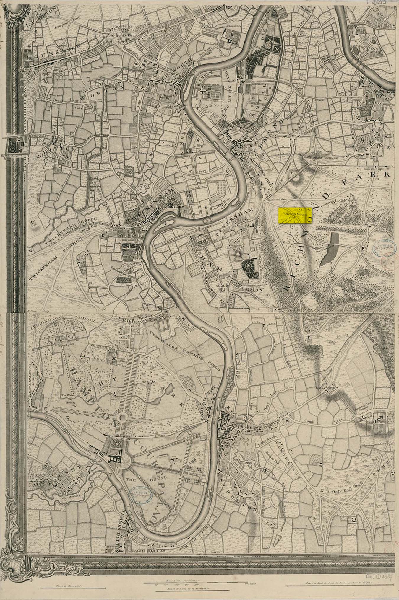
Roque’s 1746 map
Oliver’s Mound was highlighted as early as 1746 on John Roque’s map of the Country Near Ten Miles Round (London) as still standing. One hundred and fifty years later, when the Ordnance Survey lads came to map the area, it had gone. We don’t know exactly when it was demolished, so Historic England (not necessarily a good measure of accuracy) tell us its demise occurred “between 1760 and 1868”, so giving themselves at least some degree of safety!
As we can see in Mr Roque’s old map, an avenue of trees led up to the barrow. This avenue will have been created when Richmond Park and its gardens were laid out.
The round barrow was most likely Bronze Age in origin. The historian and folklorist Walter John (1093) reported that in 1834, three skeletons were found at a depth of a yard beneath the surface.
Folklore
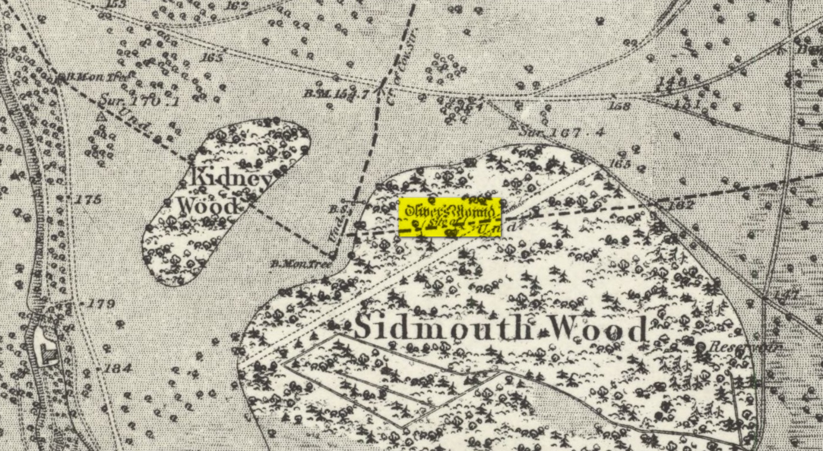
Site shown on 1873 map
Traditional tells that the name of this barrow comes from when the religious extremist, Oliver Cromwell, and his men, set up camp here. A slight variant tells that Cromwell stood here to watch a skirmish.
Tumulus (destroyed): OS Grid Reference – TQ 222 709
Archaeology & History
It seems that a great number of prehistoric remains used to exist in and around the Wimbledon Common area. This one is mentioned only briefly in Thomas Stackhouse’s (1833) rare work on early British remains, where he wrote:
“Near an old single-trenched Camp at the South West comer of Wimbledon Common, is a very small flat Barrow cut into the form of a cross: I don’t know that it has been noticed by any writer.”
The “single-trenched Camp” he described is today known as Caesar’s Camp hillfort. By the time the Wimbledon historian William Bartlett (1865) came to write his survey, the site had been destroyed. In Mr Johnson’s (1903) survey, he seems to confuse this site with the large barrow cemetery that used to exist on the northern edges of Wimbledon Common described by William Stukeley and others.
(the grid-reference to this site is an approximation).
References:
Bartlett, William A., The History and Antiquities of Wimbledon, Surrey, J. & S. Richards: Wimbledon 1865.
Johnson, Walter, Neolithic Man in North-East Surrey, Elliot Stock: London 1903.
Tumulus (possible): OS Grid Reference – TQ 2856 7555
Also Known as:
Mount Nod
Archaeology & History
Located on the old boundary line between Clapham and Battersea, what might have been a forgotten tumulus, whose memory was thankfully preserved by the renowned folklorist and historian Walter Johnson (1903), was described in his work on prehistoric Surrey. He seemed to think it serious enough to add to his survey, where he told us that,
“there still exists, near Cedars Road, Clapham, what may possibly be a round barrow. It is in the garden of a house opposite St. Saviour’s Church, and is visible to anyone passing along the old, narrow passage called Wix’s Lane. Mr. J.W. Grover, who brought the matter before the Archaeological Association in 1884, had been struck by the discovery that old maps marked the spot ‘Mount Nod Fields.’ …The mound must originally have been 70 or 80 feet across, but had been tampered with on one side for the construction of an ice-house. Mr. Grover suggested that the mound may be of Celtic date. To us, the height—some 12 feet or more—together with marked signs of reconstruction at a comparatively modern date, indicate the necessity of withholding judgment. The original tumulus may simply have been increased in height, but…digging alone could settle the question.”
Local historian Michael Green (2010) has found that there were prehistoric tombs on Clapham Common only 500 yards away, so this one along Cedar Road was not in isolation. Is the site named on the boundary perambulation records? Has it been explored since Johnson wrote about it and, if so, has its veracity as a prehistoric tomb been ascertained, or is it merely the remains of some post-medieval creation?
Tumuli (destroyed): OS Grid Reference – TL 584 600
Archaeology & History
The precise location of two prehistoric burial mounds at place with the conspicuous name of Beacon Hill, has yet to be satisfactorily located. Their existence is recorded way back, in 1279 according to P.H. Reaney (1943), when they were described as Tweynhowes, being on the boundary of Swaffham Priory. Information on them is scant and scattered with the earliest seeming to be an account by Thomas Kerrich (1817), who reported their removal and finds therein, in 1815. The editor of Archaeologia told us:
Beacon Hill urn, 1817
“The Rev. Thomas Kerrich…exhibited to the Society, an Urn, which had been found a few days before by some labourers who were employed to remove one of the Barrows upon Newmarket-heath, called the Beacon Hills. “It stood upon what probably was the surface of the earth before the tumulus was raised. The diameter of the barrow was near thirty yards, and the perpendicular height probably about eight or nine feet. There are more of these tumuli remaining, some of them very near to the place on which this, out of which the urn came, lately stood. They command an extensive view over the town of Cambridge, Gog-Magog Hills, &c.”
Subsequently a short piece in the Cambridge Chronicle in 1846 told the following:
“Two of the barrows on the edge of Newmarket Heath, belonging to the group called the Beacons, were examined in May 1846 by a party from Cambridge. In one of them nothing was found as it appeared to have been previously opened; in the other the remains of a British interment, consisting of rude vase (now in the Cambridge Antiquarian Museum), a few bones and some ashes, were discovered.”
This was echoed nearly forty years later in a survey by Charles Babbington (1883), who gave little by way of extra information; and was echoed again in Cyril Fox’s (1923) huge archaeological survey. Herein, Mr Fox told us that the two barrows were located at the “east end of a four-mile racecourse.” The only additional lore we’ve had since then is a collation of by the Royal Commission lads who thought that the respective tombs were located more precisely as the grid-references TL 5839 5998 and TL 5850 6004 respectively.
Reaney, P.H., The Place-Names of Cambridgeshire and the Isle of Ely, Cambridge University Press 1943.
Royal Commission Ancient Historical Monuments, Inventory of Historical Monuments in the County of Cambridgeshire – Volume 2: North-East Cambridgeshire, HMSO: London 1972.
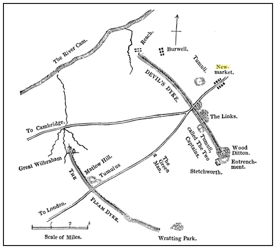
Tumuli (destroyed): OS Grid Reference – TL 6246 6048
Also Known as:
Two Howes
Archaeology & History
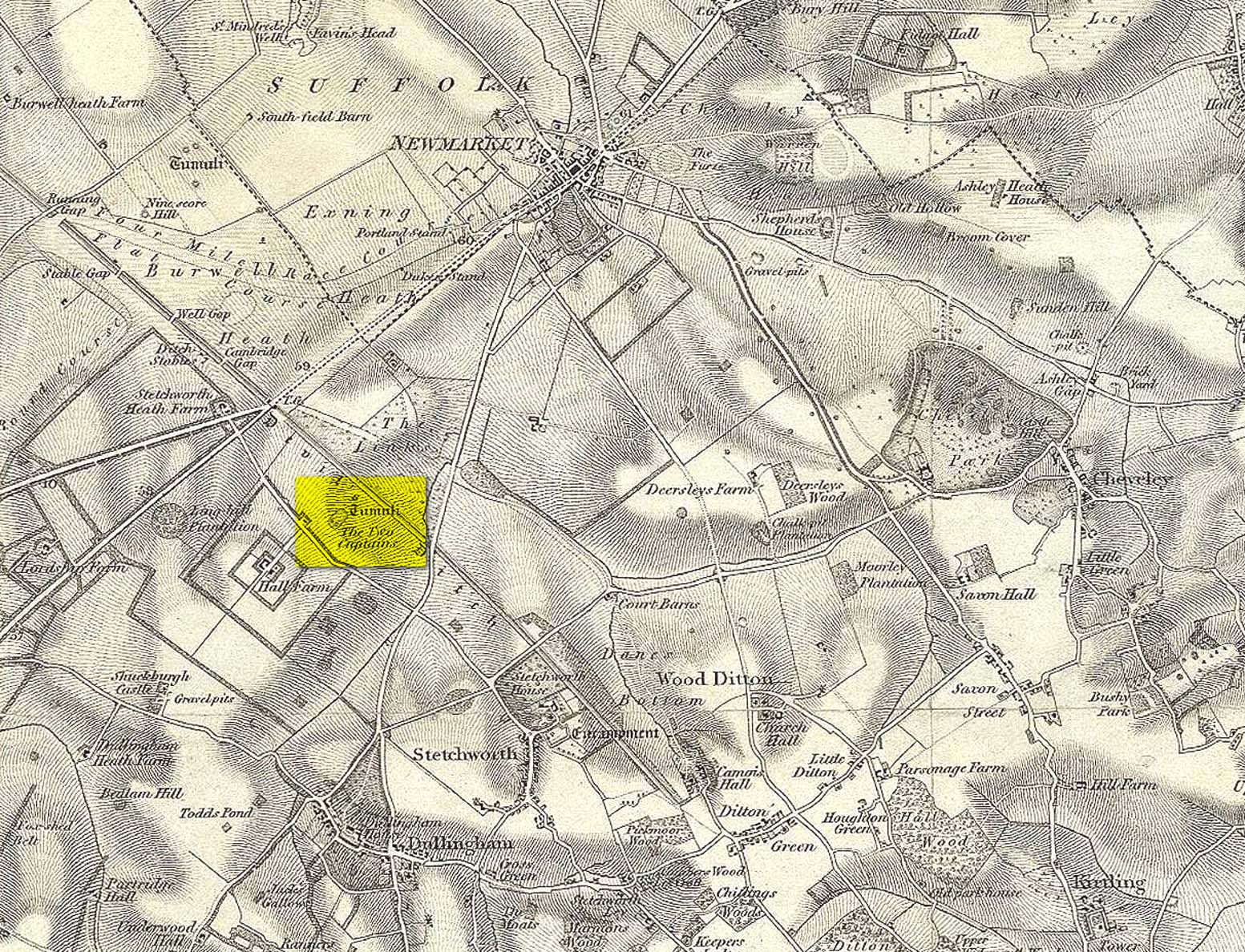
Mentioned as early as the 15th century in the Ely Cartulary as the “Tuomhowe,” or “two hills”, the place-name authority P.H. Reaney (1945) identifies this with the two “barrows” which our early cartographers map as our ‘Two Captains’.
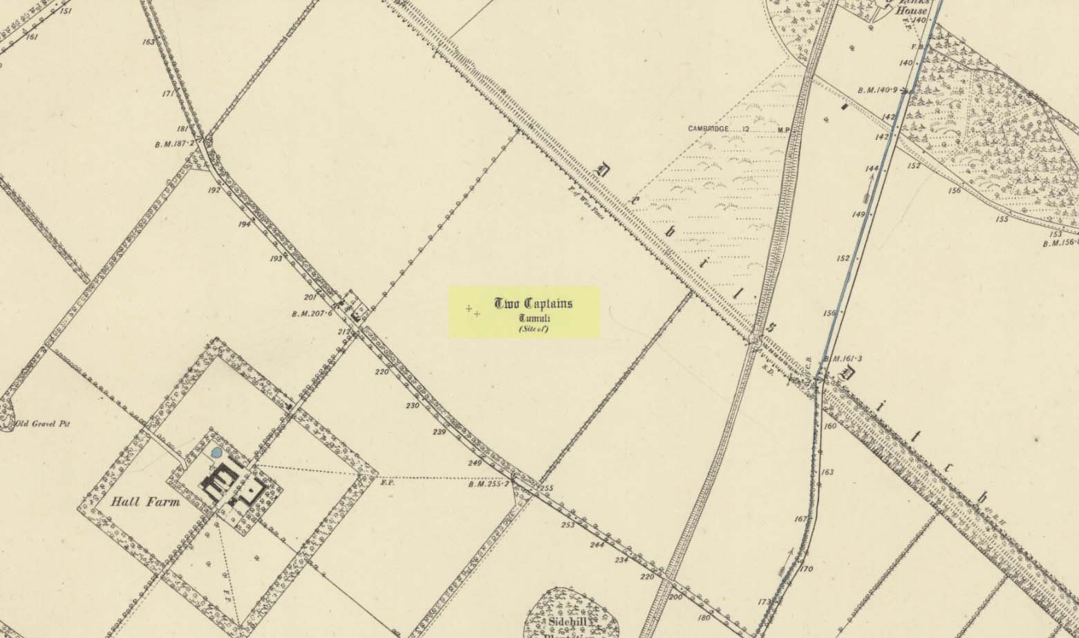
Site shown on 1834 mapSite of the Two Captains on the 1885 OS map
In the 1834 survey by the Ordnance Survey lads, these conspicuous burial mounds were clearly marked on the west side of the Devil’s Dyke, less than 2 miles south of the Newmarket Necropolis. They were seen first-hand by a number of local walkers, including A.J. King (1845) in his account of the aforementioned dyke. But on the 1885 OS map, the old tombs had apparently gone. Evidently some local knob-head had come along and took it upon himself to destroy these two burial mounds, which had lived here for thousands of years. However, despite the OS-maps indicating that it had been totally destroyed in the 1880s, a couple of later writers said that faint traces were still visible, including the historian Charles Harper. (1904) When he came here, he told how
“Little is now left of this once prominent mound, once important enough to be marked on Ordnance maps, but now ploughed nearly flat. It stands in the third field from the road, on the right hand, a field now under corn, but until forty years ago a wood.”
A.J. King’s 1845 map
Very little is known about the place and even the late great barrow fetishist, L.V. Grinsell (1936) could dig nothing out, despite the two tombs mentioned in passing by a number of writers.
Folklore
In Grinsell’s (1976) book on the folklore of ancient sites, he drops the Two Captains into a simple category of them relating to some battle, without any information. But it seems there isn’t much to go on. The local history work of Charles Harper (1904) intimates the same thing, bringing attention to the folklore of the adjacent Devil’s Dyke, as
“it is one of the many sites identified as the scene of Boadicea’s defeat by Suetonius Paulinus, but we are sceptical of this particular one, although the ancient tumulus on the outer face of the Ditch, still called the Two Captains, points to some forgotten conflict in which two leaders were slain and buried on the contested field.”
References:
Gomme, G.L., The Gentleman’s Library: Archaeology – volume 2, Elliot Stock: London 1886.
Grinsell, Leslie V., The Ancient Burial Mounds of England, Methuen: London 1936.
Grinsell, Leslie, Folklore of Prehistoric Sites in Britain, David & Charles: Newton Abbot 1976.
King, A.J., “The Devil’s Dyke, Newmarket,” in The Gentleman’s Magazine, January 1845.
Reaney, P.H., The Place-Names of Cambridgeshire and the Isle of Ely, Cambridge University Press 1943.
Royal Commission Ancient Historical Monuments, Inventory of Historical Monuments in the County of Cambridgeshire – Volume 2: North-East Cambridgeshire, HMSO: London 1972.
Tymms, S., “The Devil’s Dyke, Newmarket” in Proceedings Suffolk Inst. Archaeology. 1, 1849-53 168-70
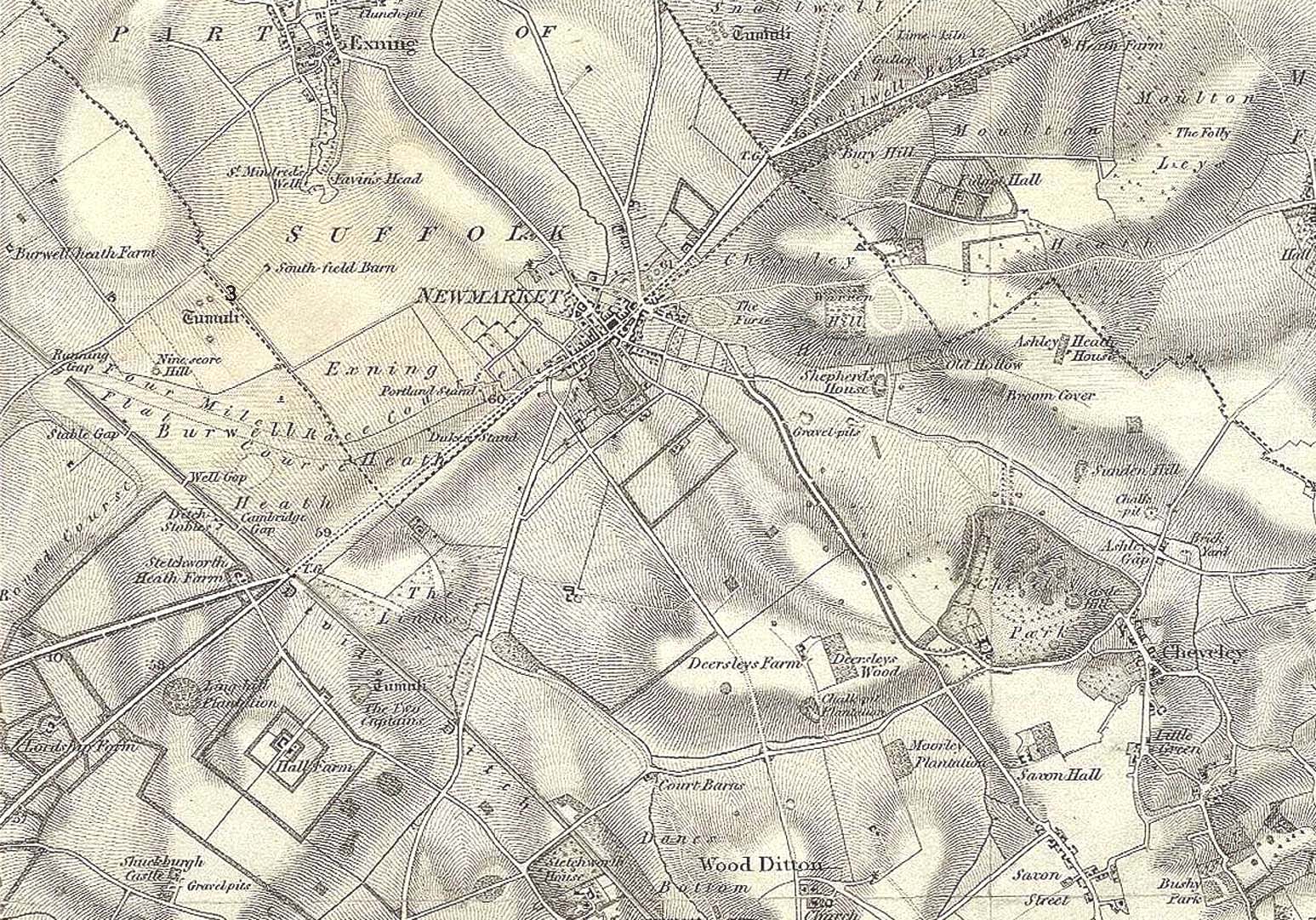
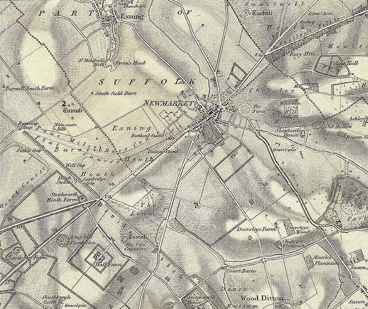
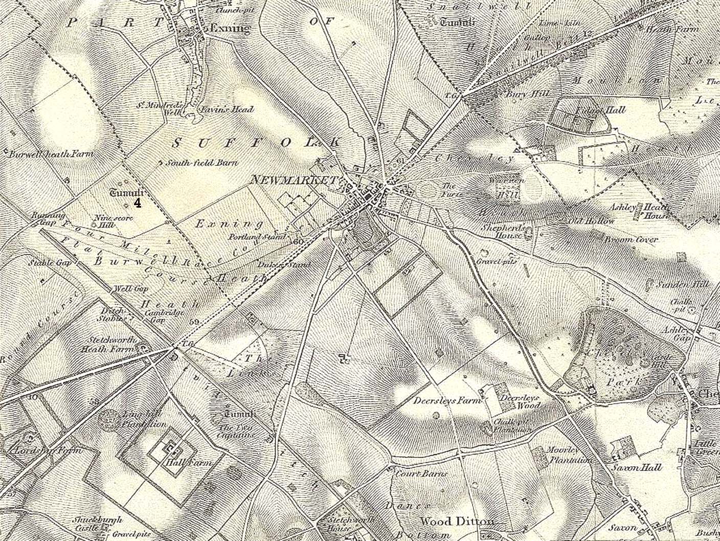
Tumulus (destroyed): OS Grid Reference – TL 6122 6358
Archaeology & History
Tumulus ‘3’ on 1834 map
This is one of at least five prehistoric tombs that were known to have existed in and around the Newmarket race-course—all long gone. It stood some 50-60 yards northeast of the Newmarket Heath (2) tumulus and was one in the cluster highlighted as ‘tumuli’ on the 1834 OS-map (right). Despite its destruction sometime in 1883, a scar of the monument was seen from the air in the 1940s by J.K.S. St Joseph as a ploughed-out ring ditch, showing it to have been some seventy feet across. Sadly, no ground trace of the monument exists.
Royal Commission Ancient Historical Monuments, Inventory of Historical Monuments in the County of Cambridgeshire – Volume 2: North-East Cambridgeshire, HMSO: London 1972.
Tumulus (destroyed): OS Grid Reference – TL 6116 6352
Archaeology & History
Tumulus 2, centre-left
This is one of at least five prehistoric tombs that were known to have existed in and around the Newmarket race-course. Found some 600 yards NNE of the Ninescore Hill tumulus, and some 40 yards from its nearest companion, it was shown as one in a group of ‘Tumuli’ on the 1834 OS-map (right) but, along with the rest, was subsequently destroyed sometime around 1883. A landscape scar of the monument was seen from the air in the 1940s by J.K.S. St Joseph as a ploughed-out ring ditch some 75 feet across. This was reported as still visible by the Royal Commission doods in the 1970s, but no ground trace whatsoever exists.
Royal Commission Ancient Historical Monuments, Inventory of Historical Monuments in the County of Cambridgeshire – Volume 2: North-East Cambridgeshire, HMSO: London 1972.
This is one of many long lost prehistoric tombs that were known to have existed in and around the Newmarket race-course, but unlike the Newmarket tumuli 1 – 4 which were all on the first OS-map of the area, this one had been destroyed before the Ordnance Survey lads came here. As a result we don’t know its exact whereabouts.
Described in both the Cambridge Chronicle and Gentleman’s Magazine in 1827, the accounts even then were talking about it in the past tense, albeit pretty recently. The race-course at Newmarket was being modified, leading to the destruction of our ancient landscape—and with it, this tumulus. In those days however, such destruction was deemed as an ‘improvement’, as Sylvanus Urban (1827) tells at the start of his account:
“The improvements making in the exercise ground at Newmarket, Cambridgeshire, have led to some discoveries which may, perhaps, tend to the elucidation of the hitherto obscure origin of the entrenchment commonly called “The Devil’s Ditch.” In removing one of the monumental remains denominated barrows, or tumuli, which are numerous in this neighbourhood, the skeleton of a person was found deposited near the surface, whose remains were too recent to be associated with the area of its place of interment; but, upon clearing away the earth to the centre of the mound, a discovery was made of an urn, of rude construction and materials, containing ashes, together with some beads, which, it is presumed, formed the ornaments of the person to whose honour the barrow was dedicated. There were also found two coins, supposed to be Roman, and a fragment of a cup, of far superior manufacture to the urn, lying promiscuously at the depth of about two feet.”
A summary of this was included in Babbington’s (1883) archaeological survey. But in Cyril Fox’s (1932) list of barrows near Cambridge he seemed to confuse this “tumulus on Exercise Ground” (no.16) with what he thought was another tumulus (no.17), which he described as, “Exact site unknown. Contained a cremation interment. Burnt bones and sherds of Bronze Age type, also Roman sherds.” The two are the same thing.
Royal Commission Ancient Historical Monuments, Inventory of Historical Monuments in the County of Cambridgeshire – Volume 2: North-East Cambridgeshire, HMSO: London 1972.
Urban, Sylvanus, “Domestic Occurrences,” in Gentleman’s Magazine, September 1827.
Tumulus (destroyed): OS Grid Reference – TL 613 633
Archaeology & History
Tumulus 4, centre-left
This is one of at least five prehistoric tombs that were known to have existed in and around the Newmarket race-course. It could be seen five-hundred-and-odd yards northeast of the Ninescore Hill tumulus and about 280 yards southeast of its Newmarket Heath 2 companion. The site was shown as one of the “tumuli” on the 1834 OS-map (right) but, along with its friends, was destroyed sometime around 1883. Unlike its companions, no scar of its remains are visible from the air so we don’t know how big it was, but I’d assume the olde fella to be of a similar size and style to its close neighbours.
Royal Commission Ancient Historical Monuments, Inventory of Historical Monuments in the County of Cambridgeshire – Volume 2: North-East Cambridgeshire, HMSO: London 1972.
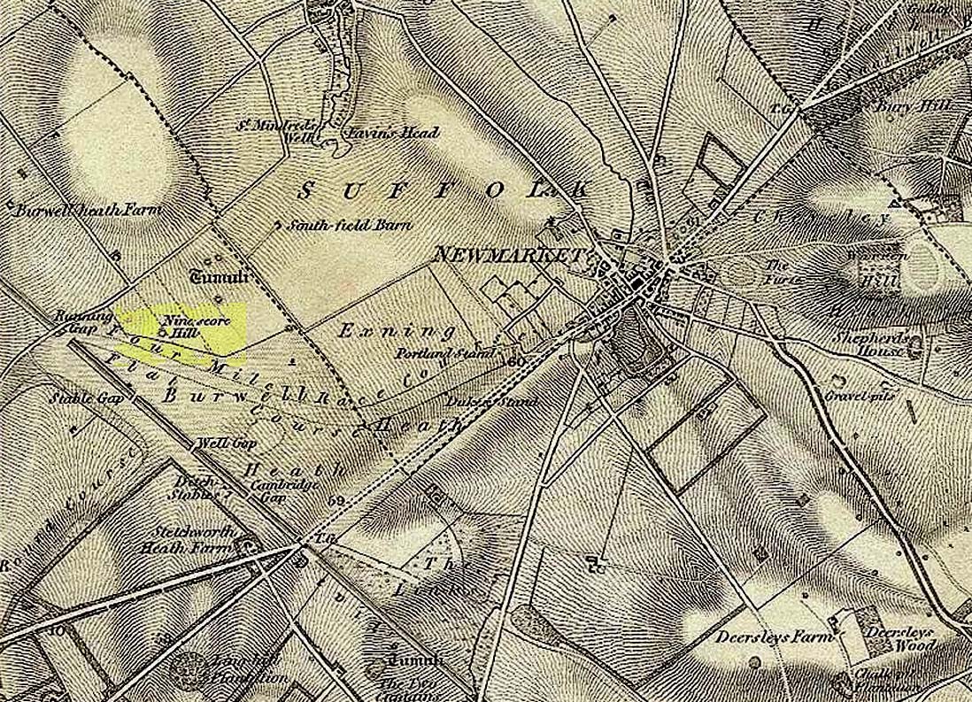
Tumulus (destroyed): OS Grid Reference – TL 6091 6304
Also Known as:
Newmarket Heath 1
Ninescore Hill Barrow
Archaeology & History
Ninescore Hill on 1834 map
Upon the small and curiously-named Ninescore Hill on the edge of Newmarket’s race-course, the old-school archaeologist Cyril Fox (1923) told that “800 yards due east of Running Gap”, was a prehistoric burial mound that was destroyed in 1885. Highlighted on the 1834 OS-map, a 19th century excavation found that the tomb “contained two inhumation interments associated with beakers,” along with some “flint arrowheads, and a secondary interment, probably Saxon.” In more recent times, the doods from the Royal Commission (1972) added the site to their inventory and noted that a faint outline—known as as ring ditch—is visible from the air when conditions are just right. But there’s bugger all left of it at ground level.
References:
Fox, Cyril, The Archaeology of the Cambridge Region, Cambridge University Press 1923.
Royal Commission Ancient Historical Monuments, Inventory of Historical Monuments in the County of Cambridgeshire – Volume 2: North-East Cambridgeshire, HMSO: London 1972.