This little known site, long since destroyed during the construction of Keighley Railway Station, was found in a curious spot, close to the bottom of the Aire Valley. Most (known) prehistoric burials occur on the higher grounds in this area. And though we don’t appear to have the exact location of the find, it was pretty close to either side of Keighley’s old railway station (which is shown as 100 yards to the other side of the road of the present station on the 1852 OS map). This may position the site as being on the grounds opposite and below St. Anne’s Church; otherwise it was getting closer to where the River Worth runs by. In Keighley & Holmes’ early (1858) work they told that,
“Whilst excavating for the Railway within about a hundred yards of the Keighley station, one of the labourers discovered three urns containing a quantity of human bones. Two of them were unluckily broken, one being large enough to hold eight or nine quarts. The one brought away whole, and seen by the present writer, may hold about a quart; it is somewhat distastefully designed, moulded by hand out of the common clay, without glaze, and rudely ornamented on the outside by some sharp implement. The once animated contents of each urn were covered by a square flat stone.”
This final remark seems to indicate the urns were located in a cist (a small stone grave), but we don’t know whether this was found within the remains of a denuded tumulus or stone cairn. However, considering the lack of any remarks about a large pile of stones (which would have been very noticeable) covering this burial site, it would seem more probable that this site was originally an earth-covered tumulus, whose visibility and knowledge had long since diminished in this part of Airedale.
References:
Keighley, William & Homes, Robert, Keighley, Past and Present, R. Aked: Keighley 1858.
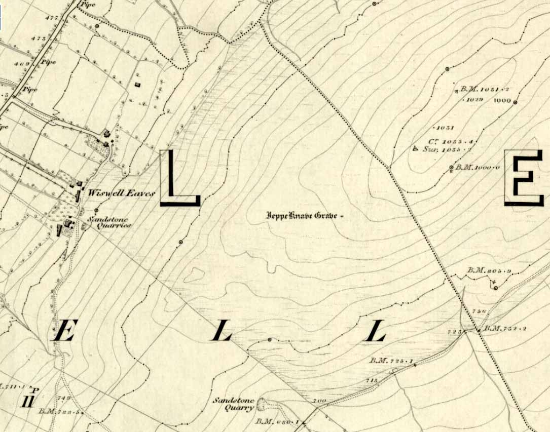
From Sabden, head up the steep Clitheroe Road towards the Nick o’ Pendle, turning left 100 yards before the hilltop and along the dirt-track for a few yards, before veering up the winding footpath to the hilltop. When you’re at the peak of this little bit o’ moorland, go to your left (west), following the small path into the grasses and heather all the way on for a few hundred yards till you hit the triangulation pillar. Go past this, over one stile (north) and then immediately at right-angles (west) over another stile and downhill for about 100 yards until you’re on the rough grassland level. Keep your eyes peeled as you’re walking until you see what looks like a denuded stone-lined pit, much overgrown — with the main feature (showing that you’ve hit the target) being the engraving on one of the larger rocks: “Jeppe Knave Grave”.
Archaeology & History
The Jeppe Knave Grave
First described in early perambulation records of 1326 CE, this is a small but intriguing site found on the far southwestern slopes of Pendle Hill, on the ridge beneath the triangulation pillar of Wiswell Moor. It’s a small and overgrown cairn with a general archaeological association of prehistory attached—though no detailed excavation has ever been done here, despite local archaeologists having access to a large grant to explore this region a short while ago.¹ But up North, as many of us know, archaeology is given little priority and those who do decent exploratory work under the umbrella of such academic quarters tend to be few and far between. Thankfully we had the northern antiquarian and local writer John Dixon (1993) nearby who gave us the best overview of the site. He wrote:
“This landscape feature, known as Jeppe Knave Grave, stands at a place called The Lows high on Wiswell Moor and takes the form of a low grass-covered mound 16M in diameter with a stone filled depression in the centre 5 x 3 M. This feature appears to be a mutilated cairn and has been tentatively ascribed to the Bronze Age. The outer ring of stones can be discerned in the rough pasture at the perimeter – yellow in dry conditions, showing the circular shape. Given the large size of the stones here, the cairn may have been of a chambered type/passage tomb of the Neolithic period, and if this was the case the burial (or burials?) was one of great importance.
“Upon the largest stone are inscribed the words ‘JEPPE KNAVE GRAVE and a cross (inscribed by the Scouting Association in the 1960’s). The stone marks the final resting place of Jeppe Curteys (Geoffrey Curtis), a local robber who was decapitated for his crimes in the first year of Edward III, 1327. The name first occurs in a record of the boundaries between Wiswall and Pendleton dated 1342.
“…In those times the punishment of decapitation was unusual, being reserved for those of noble birth. So who was this Jeppe Curteys, punished by decapitation and later buried on the high ridge of Wiswell Moor in a pre-Christian burial mound on the then boundary of parishes? That intriguing story we may never know. But to be buried in such a manner and place was indeed a great indignity – interment in what might be considered in those times to be a ‘pagan’ or ‘devilish’ spot. It may be that to bury a man in such a place was to literally ‘send him to the devil’. Alternatively one could ask: ‘Was the site thought then to be the burial spot of some noble ancestor, and Jeppe being of possible noble birth interred with great dignity? Again we may never know, yet it is significant that this lonely spot is still identified with a man who was executed 700 years ago.
In 1608 it was stated that one Robert Lowe had taken a stone from the grave and used it as a cover of his lime kiln.”
Old codgers from the local Senile Society, inspecting York Minster!Agatha Lyons’ 1871 sketch
The design of the cairn here is unlike the ones you usually come across on the Lancashire and Yorkshire moorlands. The edges of the Jeppe Knave Grave are walled and much more well-defined than the large rock piles that we find scattering our uplands. A similar though larger cairn with features similar to these can be seen in the large Low Hill tumulus on Elslack Moor near Earby, about ten miles northeast of here…
Other prehistoric remains scatter the many rolling hills that you can see from here: mainly prehistoric tombs sat upon hilltops as far as the eye can see. John pointed out what may be the remains of another tumulus that can be seen on the nearby horizon a few hundred yards NNW from here, overlooking the gorgeous village of Pendleton and the landscape beyond…
References:
Dixon, John, Journeys through Brigantia – volume 9: The Ribble Valley, Aussteiger Publications: Barnoldswick 1993.
Whitaker, Thomas Dunham, An History of the Original Parish of Whalley – volume 2, George Routledge: London 1876.
¹ John Dixon informed us how the people in question spent the grant — somewhere in the region of £50,000 — on exploring some modern architectural features, instead of exploring some of the little-known sites and seeking out others on these hills.
* John is the author of many fine historical travel guides, including the Journeys through Brigantia series. See the titles in the Lancashire Bibliography and Yorkshire Bibliography for a more complete listing of all his books to date. If you wanna buy any of his works, or make enquiries regarding them, email John at: lancashirebooks@fsmail.net – or write to him direct, at: John Dixon, Aussteiger Publications, 21 Lowergate, Clitheroe, Lancashire BB7 1AD.
Crowned by a clump of trees (planted in 1740), this hilltop site is one of the more impressive of a number of tombs hereby, with its nearest other neighbour being 70 yards southeast of here. One of Dorset’s early tribal meeting places (Anderson 1934), the tomb was illustrated on Isaac Taylor’s 1765 map of the region and was dug into in 1858 “on the orders of a local magnate” (Marsden 1999), damaging some substantial portion of the tomb. Of this, craniologist and antiquarian John Thurnam was most displeased; for in his description of the opening of Culliford Tree he wrote:
“A wide trench had been dug through it one side, from the summit and the rubble which had been thrown out had not been replaced… Another subject of regret was the fact that though, as we were told by the neighbouring rustics, human remains, with pottery and certain other relics, were found in the barrow, no authentic account of the exploration had, so far as we could learn, been put to print.”
Leslie Grinsell (1959) found the same trouble in his assessment of this site; and the Royal Commission (1970) lads could only describe the site thus:
“Large trench on south and top almost certainly dug in 1858 when four secondary extended inhumations, one with necklace of amber and two gold-plated beads, and cremation with incense cup in collared urn, were found.”
However, it seems that the necklace and gold-plated beads have been “lost” — i.e., someone has them in their own private collection somewhere!
Folklore
This is one of very few tombs in this part of the country where we find the tradition of fairy music. Grinsell (1959) told that:
“The Culliford Tree barrow, formerly the meeting place of the Hundred of Culllingford Tree, is also known as the Music Barrow from the belief that music could be heard beneath the mound by those who listened at the apex at midday.”
References:
Anderson, O.S., The English Hundred-Names, Lunds Universitets Arsskrift 1934.
Marsden, Barry M., The Early Barrow Diggers, Tempus: Stroud 1999.
Royal Commission on Historical Monuments, An Inventory of Historical Monuments in the County of Dorset – Volume 2: South-East, Part 3, HMSO: London 1970.
Warne, Charles, Celtic Tumuli of Dorset: An Account of Personal and other Researches in the Sepulchral Mounds of the Durotriges, Smith: London 1866.
Tumulus (destroyed): OS Grid Reference – TA 0422 7726
Archaeology & History
A once-impressive haunted burial mound on the southern edge of Folkton parish, all that remains of the place now are aerial images showing the ghostly ring of its former site. Commenting on the destruction of this burial mound before he had chance to give it his full attention, in William Greenwell’s (1877) magnum opus he wrote the following:
“Elf Howe had been removed to a great extent, and the grave had been dug out before I had an opportunity of examining it. I however got an account of what was discovered from the foreman on the farm, and I was able personally to inspect a small portion which had not been disturbed. The barrow had been 60ft in diameter and 6ft high, and was made of earth and chalk. Near the centre a deposit of burnt bones was met with, over which some large flints were placed; this was at a depth of 4ft, and as a great quantity of burnt earth was observed immediately round the bones, it is probable that the body had been burnt on the spot where the bones were placed. Two unburnt bodies were found on the south side of the mound, with one of which a vessel of pottery was associated. At a distance of 17ft south-south-east of the centre I found the body of a strongly-made man, laid on the right side, with the head to the south and the hands to the knees; he body was placed about 6in above the natural surface. Immediately below the head was the body of a very young child, the bones of which were too much decayed to admit of anything being made out beyond the fact that it was a child’s body which was laid there. Still lower, and on the natural surface, was a patella, a radius, and some other bones of a body, which had been disturbed, probably in the interring of the person who was found buried above. At the centre was a grave, lying northwest and southeast, 7ft by 6½ft and 2½ft deep. On the bottom at the north side was the body of a strongly-made man in the middle period of life, whose head…was to the south, but my informant could not remember on which side the body was laid; at the head was a ‘food vessel’, which, from the fragments that have been preserved, must have been a rudely-made one with unusually thick walls.”
Folklore
Although antiquarians and archaeologists such as Elgee, Grinsell, Gutch, Johnson and others each tell (in their own respective ways) that Elf Howe “testifies to a widespread belief in goblin-haunted barrows” — albeit in the linguistic ‘elven’ of the Scandinavian invaders — we appear to have lost the original tale behind this fairy-haunted site.
References:
Greenwell, William, British Barrows, Clarendon Press: Oxford 1877.
This once impressive tumulus a half-mile east of the village was first mentioned in the Bardney Cartulary in the early 13th century, where is was written as Spelhou. Suggested by Olof Anderson (1934) to have been an early moot site — “the meeting place of the Torbar Hundred” — this appears to be confirmed in Smith’s (1937) etymological analysis where he ascribes Spell Howe to be literally, “‘Speech mound’, from OE spell, speech and haugr” (burial mound). Rising about four-feet above ground level, this is a traditional ’round barrow’ type of tumulus. In recent years, reports tell that it has been built onto with some fencing. Hopefully the present land-owners now look after the place!
References:
Anderson, O.S., The English Hundred-Names, Lunds Universitets Arsskrift 1934.
Mortimer, J.R., Forty Years Researches in British and Saxon Burial Mounds of East Yorkshire, Brown & Sons: Hull 1905.
Smith, A.H., The Place-Names of the East Riding of Yorkshire and York, Cambridge University Press 1937.
Cairnfield (destroyed): OS Grid Reference – TQ 702 590
Archaeology & History
Ground-plan
In recent years it seems that very little has been written about this seemingly lost site, long since destroyed by the self-righteous advance of the Industrialists. It seems to have been an important place, as there were many cremated remains here in more than a dozen individual burial urns, some with flints deposited in them. The site was first described in a meeting of members of the Society of Antiquaries in 1898 by a Mr Frederick James. He talked about the site and some brief digging work around the area, thus:
“The site of the urnfield is on land belonging to Mr William Wigan, of Clare House, East Malling, and it was owing to his kind permission and active cooperation that I was enabled to visit the spot, which is on a small plateau above the River Medway, 350 yards to the southwest of New Hythe church, and between the river and the road leading from Rochester to Town Malling…
“The immediate neighbourhood…has been from time to time highly productive of archaeological remains dating from the Palaeolithic times and extended down to the Roman occupation… (But at) the Larkfield urnfield, the first indication that was afforded of the uses to which the area had been put in Romano-British times was the accidental discovery, whilst planting fruit trees, of some fragments of pottery (including portion of a Samian patera) found at the point marked A on the plan. A flat tile was found covering the fragments.”
Much more was found hereby, with the majority of the finds being “a group of urns containing cremated interments found in the urn-pits.” Although James (1898) described them as dating from the Romano-British period, from his description and illustrations it would seem that the remains here were probably of an earlier date, perhaps Iron- or even Bronze Age. But we may never know for sure.
Reference:
James, Frederick, “Discovery of a Romano-British Urnfield at Larkfield, near Maidstone,” in Proceedings of the Society of Antiquaries, 17:1, 1898.
From the Askwith Moor Road parking spot and walk up the road for about 500 yards an head to your right (east) onto he moor, above the rocky ridge known as Snowden Crags. After 100 yards or so of walking through the heather, the entire cairnfield is under your very feet! If the heather’s grown, you probably won’t see a thing.
Archaeology & History
First described in Eric Cowling Rombald’s Way (1946), where he mentions around 30 cairns on the moorland plain immediately west of the Snowden Moor settlement. These were plainly visible when Richard Stroud and I visited here in 2005, thanks mainly to the fact that the heather had been burnt away. Once it’s grown back, virtually all of these tombs will be hard to find. I first had fortune to see some of these tombs on a visit here with Graeme Chappell about 15 years ago, but only a little of the cemetery was then visible. Following another visit to the site this week, a great deal more has become visible, thanks again to heather-burning on the moors.
One of around 30 cairns on the ridge…and another one!
Curiously omitted from the Nidderdale Archaeological survey report of sites in this region (anyone know why?), the cemetery itself stretches from the western edge of the Snowden Moor settlement, several hundred yards west along the flat moorland plain towards the moorland road, stopping a short distance before the line of old grouse butts. It is highly likely that some of the stones in the grouse-butts originated in some of the prehistoric cairns along the ridge. And if summat aint done about it, there’s a likelihood this could easily happen again in the near future.
…and another!
The easternmost cairn touches the very edge of the D-shaped settlement; and another of them is right next to a cup-marked stone. Whilst a number of the cairns along this ridge are much like those found on the moors above Ilkley, Bingley, Middleton, Askwith Moor, Earby, etc — averaging 2-3 yards in diameter and less than 2 feet high amidst the peat and decaying herbage — one notable feature to many of these tombs is the inclusion of a rather large, singular boulder, against which or around are propped the smaller stones, typical of cairns found elsewhere in the region. This ‘large boulder’ characteristic is not common at other tombs in the mid-Pennines, but seems specific to this graveyard. Neither do the large boulders seem set in any particularly consistent fashion. There is the possibility that they were originally above the smaller cairn of stones, but this is purely hypothetical and non-verifiable without excavations.
The important Snowden Crags cairn circle, discovered by the hardworking Keighley volunteer Michala Potts on Thursday, 20 May, 2010, can be found on the northern part of this cairnfield.
References:
Cowling, Eric T., Rombald’s Way: A Prehistory of Mid-Wharfedale, William Walker: Otley 1946.
Get here before the heather grows back! From the Askwith Moor parking spot, walk up the road (north) and turn left on the moorland track, past the triangulation pillar, then the ranger’s hut on the edge of the hill, and head WNW along and down the gradual slope. You’ll get to a row of grouse butts after a few hundred yards and, if you’re lucky to find it, an old OS trig-marked arrow carved on one of the low-lying stones. This stone is about 10 yards away from the cairn!
Archaeology & History
There are no previous references to this site. It was discovered by the hardworking Keighley volunteer, Michala Potts of Bracken Bank, on May 20, 2010, and was the most visible of at least three prehistoric cairns on the sloping edge of this hill. The main one illustrated here is about 3 yards in diameter and only a foot or two high. Typical of the many Bronze Age cairns scattering the moors north and south of here, several others are in close attendance. It seems as if some of the stone from this cairn has been robbed to build some of the grouse-butts that stretch across the moors hereby.
Single cairn on Askwith MoorSame cairn, looking uphill
About 50 yards away from the main cairn shown in the photos are a couple of others of the same size and nature. And if we walk over the other side of the nearby rounded hill immediately south, a couple of other cairns are in evidence. However, we didn’t spend too much time here getting any images, as other sites on the moor were beckoning and we were running out of good daylight!
The name of this area seems a little odd: “High Low” — and our old place-name masters say little about it in the Yorkshire directories. The name is shown in the earliest large-scale OS-maps, but the contradiction of a high low ridge probably derives from the word originally being lowe, or “hlaw”: which as A.H. Smith (1956) said,
“In (old english) the common meaning in literary contexts is ‘an artificial mound, a burial mound,'”
Cairn to centre, with 1 more on near horizon
which is exactly what we have found here — or several of them scattered about. This tumulus derivation is echoed by modern place-name authorities like Margaret Gelling (1988), etc. Gelling told how the word hlaw, or low, and its variants, “was used of burial mounds over a wide area, from the south coast to the West Riding.” Much as we’ve found on this hill at Askwith Moor! We’ve yet more exploring to do in and around this area in the coming weeks. God knows what else we’ll find!
References:
Cowling, Eric T., Rombald’s Way: A Prehistory of Mid-Wharfedale, William Walker: Otley 1946.
Gelling, Margaret, Signposts to the Past, Phillimore: Chichester 1988.
Smith, A.H., English Place-Name Elements – volume 1, Cambridge University Press 1956.
From the large parking spot by the roadside along Askwith Moor Road, walk up (north) 250 yards until you reach the gate with the path leading onto Askwith Moor. Follow this along, past the triangulation pillar until you reach the Warden’s Hut near the top of the ridge and overlooking the moors ahead. Naathen — look due south onto the moor and walk straight down the slope till the land levels out. If you’re lucky and the heather aint fully grown, you’ll see a cluster of stones about 500 yards away. That’s where you’re heading. If you end up reaching the Woman Stone carving, you’ve walked 100 yards past where you should be!
Archaeology & History
Discovered on the afternoon of May 13, 2010, amidst another exploratory ramble in the company of Dave Hazell. We were out looking for the Woman Stone carving and a few others on Askwith Moor, and hoping we might be lucky and come across another carving or two in our meanderings. We did find a previously unrecorded cup-marked stone (I’ll add that a bit later) — and a decent one at that! — but a new cairn-field was one helluva surprise. And in very good nick!
Cairn A, looking northwestCairn A, looking east
There are several cairns sitting just above the brow of the hill, looking into the western moors. Most of these are typical-looking single cairns, akin to those found on the moors above Ilkley, Bingley and Earby, being about 3 yards across and a couple of feet high amidst the peat and heather covering. But two of them here are notably different in structure and size (and please forgive my lengthy description of them here).
We found these tombs after noticing a large section of deep heather had been burnt back, and a large mass of rocks were made visible as a result. Past ventures onto these moors when seeking for cup-and-ring carvings hadn’t highlighted this cluster, so we thought it might be a good idea to check them out! As I approached them from the south from the Woman Stone carving (where we’d sat for a drink and some food, admiring the moors and being shouted at by a large gathering of geese who did not want us here), it became obvious, the closer I got, that something decidedly man-made was in evidence here.
Cairn A, looking south
Walking roughly northwards out of the heather and onto the burnt ground, a cairn-like feature (hereafter known as “Cairn A”) was right in front of me; though this seemed to have a ring of small stones — some earthfast, others placed there by people — surrounding the stone heap. And, as I walked around the edge of this large-ish cairn (about 9 yards in diameter and 2-3 feet tall), it was obvious that a couple of these outlying stones were stuck there by humans in bygone millenia. The most notable feature was the outlying northernmost upright: a small standing stone, coloured white and distinctly brighter than the common millstone grit rock from which this monument is primarily comprised. As I walked round it — adrenaline running and effing expletives emerging the more I saw — it became obvious that this outlying northern stone had long lines of thick quartz (or some crystalline vein) running across it, making it shine very brightly in the sunlight. Other brighter stones were around the edge of the cairn. It seemed obvious that this shining stone was of some importance to the folks who stuck it here. And this was confirmed when I ambled into another prehistoric tomb about 50 yards north, at “Cairn B.”
Cairn B, looking northCairn B, looking east
Cairn B was 11 yards in diameter, north-south, and 10 yards east-west. At its tallest height of only 2-3 feet, it was larger than cairn A. This reasonably well-preserved tomb had a very distinct outlying “wall” running around the edges of the stone heap, along the edge of the hillside and around onto the flat moorland. Here we found there were many more stones piled up in the centre of the tomb, but again, on its northern edge, was the tallest of the surrounding upright stones, white in colour (with perhaps a very worn cup-marking on top – but this is debatable…), erected here for some obviously important reason which remains, as yet, unknown to us. Although looking through the centre of the cairn and onto the white upright stone, aligning northwest on the distant skyline behind it, just peeping through a dip, seems to be the great rocky outcrop of Simon’s Seat and its companion the Lord’s Seat: very important ritual sites in pre-christian days in this part of the world. Near the centre of this cairn was another distinctly coloured rock, as you can see in the photo, almost yellow! Intriguing…
The smaller “Cairn C”
Within a hundred yards or so scattered on the same moorland plain we found other tombs: Cairns C, D, E, F, G and H — but cairns A and B were distinctly the most impressive. An outlying single cairn, C, typical of those found on Ilkley Moor, Bingley Moor, Bleara Moor, etc, was just five yards southwest of Cairn A, with a possible single cup-marked stone laying on the ground by its side.
Just to make sure that what we’d come across up here hadn’t already been catalogued, I contacted Gail Falkingham, Historic Environment team leader and North Yorkshire archaeological consultant, asking if they knew owt about these tombs. Gail helpfully passed on information relating to a couple of “clearance cairns” (as they’re called) — monument numbers MNY22161 and MNY 22162 — which are scattered at the bottom of the slope below here. We’d come across these on the same day and recognised them as 16th-19th century remains. The cairnfield on top of the slope is of a completely different character and from a much earlier historical period.
We know that human beings have been on these moors since mesolithic times from the excess of flints, blades and scrapers found here. Very near to these newly-discovered tombs, Mr Cowling (1946) told that:
“On the western slope of the highest part of Askwith Moor is a very interesting flaking site. For some time flints have been found in this area, but denudation revealed the working place about August, 1935. There were found some twenty finished tools of widely different varieties of flint. A large scraper of red flint is beautifully worked and has a fine glaze, as has a steep-edged side-blow scraper of brown flint. A small round scraper of dull grey flint has the appearance of newly-worked flint, and has been protected by being embedded in the peat…One blade of grey flint has been worked along both edges to for an oblong tool… The flint-worker on this site appears to have combed the neighbourhood to supplement the small supply of good flint.”
All around here we found extensive remains of other prehistoric remains: hut circles, walling, cup-and-ring stones, more cairns, even a probable prehistoric trackway. More recently on another Northern Antiquarian outing, we discovered another previously unrecognised cairnfield on Blubberhouse Moor, two miles northwest of here.
References:
Cowling, Eric T., Rombald’s Way: A Prehistory of Mid-Wharfedale, William Walker: Otley 1946.
Jack, Jim, “Ancient Burial Ground and Bronze Age Finds on Moor,” in Wharfedale Observer, Thursday, May 27, 2010.
From Earby, go eastwards up the steep moorland Coolham Lane. A coupla hundred yards up past the little reservoirs on your right there’s a tall, large wooden stile to climb over, up the old heaps of quarried stone and onto the flat moorland plain of Bleara Moor. You’re here! If the heather’s grown back however, you’ve no chance of seeing ’em!
Archaeology & History
One of at least a dozen small cairns on NW of Bleara Moor
When we came up here the other day (ostensibly to check out the great Bleara Lowe tombs on top of the moor), a grey wet day scattered its more darkened light across the moor, which thankfully had been burnt back a few months previous. If this hadn’t happened, we’d have never seen what we found: a scattering of at least a dozen small single cairns, typical of those found on the upper and lower slopes of Green Crag Slack on Ilkley Moor. They’re on the lower northwest-facing plain of Bleara Moor and all are roughly the same size: about 3 yards by 3 yards across and only a foot or two in height, much overgrown in peat and vegetation. Although we found a good number of these small cairns where the heather had been burnt away, there also seemed to be others in the long heather itself, but this was, of course, hard to say with any certainty. A few more exploratory ventures in and around the moor would be good after the next heather-burning sessions!


")


