Water End Maypole, North Mymms, Hatfield, Hertfordshire

Maypole (removed):  OS Grid Reference – TL 2296 0410

Getting Here

On the east side of Warrengate Road, approached from Welham Green via Dixons Hill Road, or from Brookmans Park via Bradmore Lane.

Archaeology & History

o khy 01170

A 1920 photograph of the Public House. The Maypole was believed to have been in the garden grounds to the rear.

The exact position of the pole is not marked on the 1896 25″ OS map, as it is probable that it had been removed by the middle of the nineteenth century (like the majority of the permanent Hertfordshire maypoles), but local belief in the 1950s and 60s was that it had been in the garden of the Old Maypole (originally known as ‘The Maypole’) public house, which adjoined the smithy in Warrengate Road, Water End.  The public house is stated to have been built around 1520, with later additions, but is now a private house.

The population of Water End and nearby Welham Green was predominantly employed in agriculture, domestic service and straw plaiting, but the area’s proximity to London probably speeded the demise of the ancient traditions like maypole dancing .

Maypole North Mymms

The 1896 OS 25″ map, showing the garden ground to the rear of the public house

Doris Jones-Baker writes: “The old Hertfordshire maypoles, on May Day decorated with ribbons and a bunch of spring flowers at the top, were described as being ‘as high as the mast of a vessel of a hundred tons, painted often in a diagonal or spiral pattern from bottom to top in yellow and black, or often in vertical stripes of red, white and blue’”

Interestingly, the rear of the public house garden adjoins the Swallow Holes, a geological feature where the intermittent flowing waters of the Mimmshall Brook disappear into the chalk in as many as 15 sink holes. Hertfordshire has an ancient tradition of ‘woe-waters’ related to the local geology, where the flowing or not of a stream or spring was seen to herald ‘sorrow to come’. From personal memory the Mimmshall Brook is normally a dry stream bed which can in winter suddenly turn into a raging torrent, flooding the land behind The Old Maypole. Any tradition of it having been a woe-water has though been lost. But it is just possible that long ago the coming of May Day was also seen to herald the end of flooding of the Mimmshall Brook and may explain the siting of the pole.

The last year that people danced is not recorded, but the local maypole tradition continued; this writer remembers ribbon dancing as a very small child to a fiddle accompaniment around a maypole erected at the nearby, but long demolished Waterend C.E. Primary School, which closed in 1960.

Folklore

As well as Maypole dancing, Hertfordshire had a rich tradition of May day ritual and song, which despite the county’s proximity to London, survived long enough for some of it to be recorded for posterity. While there does not seem to be any ritual recorded for North Mymms, the following was recorded at nearby Hatfield. “On may morning, dressed in white and holding bunches of Hawthorn or, in late seasons, blackthorn blossoms the children sang door to door a local version of the May song, which began:

‘A bunch of May I bring unto you
And at your door I stand,
Come pull out your purse,
You’ll be none the worse
And give the poor Mayers some money….’”

References:

  1. North Mymms Local History Society, North Mymms Pictures From The Past, Welham Green, 2002
  2. Jones-Baker, Doris, The Folklore of Hertfordshire, B.T.Batsford, London, 1977
  3.  Kingsford, Peter, North Mymms People in Victorian Times, Brookmans Park, Hertfordshire, Privately Published, 1986

© Paul T. Hornby 2016 The Northern Antiquarian 


Robin Hood & Little John Stones, Whitby, North Yorkshire

Standing Stones (destroyed?):  OS Grid Reference – NZ 9171 0952

Also Known as:

  1. Robin Hood’s Pillars

Archaeology & History

The 2 stones on 1853 map

The 2 stones on 1853 map

References to these old standing stones are scarce—at least in archaeology books anyway.  Even the usually diligent masters of Burl (1993) and Thom (1990) missed them!  But thankfully our folklorists and antiquarians with their keen interest in popular culture have written about these long lost monoliths, which could once be seen in fields just a mile or so south of Whitby town.

The earliest known account of the site is as the “Robyn-Hood-stone” in records dating from 1540 CE cited in the Cartularium Abbathiae de Whiteby (1881).  It was later described in land registers in 1713 and the fields in which they stood were—and still are—respectively known as Robin Hood’s Close and Little John’s Close.

These Whitby monoliths—like their namesakes in Northamptonshire— weren’t too big.  In Mr Young’s (1817) early description, when the stones were still visible, he told how Robin Hood’s stone was “a stone pillar about a foot square and four feet high”, and Little John’s Stone was “a similar pillar about two-and-a-half feet high.”  Mr J.C. Atkinson, the editor of the Cartularium (1881), also told that the two stones were “still in situ in the earlier part of the present century,” continuing:

“Both stones have now been removed, and are, I was informed, set up again near the enclosing fence of the field in which they stood. Almost beyond question , like the other monoliths of the district, they marked the site of ancient British interments.”

So—do the remains of these old stones still exist somewhere close by as J.C. Atkinson said, either in the walling, as a gatepost, or just pushed over and now covered in grass (like the long lost Thief Thorne standing stone near Addingham)?  Are any northern antiquarians living close by who might enable their rediscovery?

Folklore

A number of writers exploring the mythic histories of Robin Hood have included this site in their surveys, usually repeating the earlier creation myths about them that could be heard in popular culture.  The Whitby historian George Young (1817) told the tale:

“According to tradition, Robin Hood and his trusty mate, Little John, went to dine with one of the Abbots of Whitby, and, being desired by the Abbot to try how far each of them could shoot and arrow, they both shot from the top of the Abbey, and their arrows fell on the west side of Whitby Laithes, beside the lane leading from thence to Stainsacre; that of Robin Hood falling on the north side of the lane and that of Little John about a hundred feet further, on the south side of the lane.”

Whitby folklorist P.S. Jeffrey (1923) took this myth literally, saying how the distance of the arrows fired by the respective folk heroes was “scarcely credible, as the distance in each case is about a mile-and-a-half.”  However, the earlier historian Lionel Charlton (1779) thought the incredible feat quite credible!

The distance between the Abbey and the stones is 1.36 miles (2.2km); but it may be that the direction related in the tale was more important than the distance, as the alignment between the two sites runs northwest to southeast—or southeast to northwest, whichever you prefer!—and may relate to an early astro-archaeological alignment.  Might…..

References:

  1. Anonymous, “Robin Hood in Yorkshire“, in Yorkshire Folk-Lore Journal – volume 1, T.Harrison: Bingley 1888.
  2. Anonymous, “Whitby Arms,” in Yorkshire Folk-Lore Journal – volume 1, T.Harrison: Bingley 1888.
  3. Benedicti, Ordinis S., Cartularium Abbathiae de Whiteby – volume 2, Andrews: Durham 1881.
  4. Burl, Aubrey, From Carnac to Callanish, Yale University Press 1993.
  5. Charlton, Lionel, The History of Whitby and Whitby Abbey, T. Cadell: York 1779.
  6. Doel, Fran & Goeff, Robin Hood: Outlaw or Greenwood Myth, Tempus: Stroud 2000.
  7. Green, Barbara, The Outlaw Robin Hood – His Yorkshire Legend, KCS: Huddersfield 1992.
  8. Gutch, Mrs, County Folk-lore – volume 2: North Riding of Yorkshire, York and the Ainsty, David Nutt: London 1901.
  9. Jeffrey, P. Shaw, Whitby Lore and Legend, Whitby 1923.
  10. Mitchell, W.R., Exploring the Robin Hood Country, Dalesman: Clapham 1978.
  11. Parkinson, Thomas, Yorkshire Legends and Traditions – volume 2, Elliot Stock: London 1889.
  12. Thom, A., Thom, A.S. & Burl, Aubrey, Stone Rows and Standing Stones – 2 volumes, BAR: Oxford 1990.
  13. Young, George, The History of Whitby and Streoneshalh Abbey – volume 2, Clark & Medd: Whitby 1817.

© Paul Bennett, The Northern Antiquarian


Moor Lane Well, Gomersal, West Yorkshire

Healing Well:  OS Grid Reference – SE 2071 2677

Archaeology & History

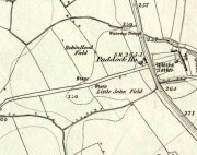
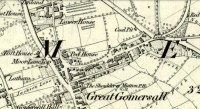
Moor Lane Well on 1847 OS-map

Moor Lane Well on 1847 OS-map

Not far from the old maypole, the Moor Lane Well was the innocuous-sounding site where legend told that a phantom horse was once seen running up and down the lane—said by old locals to be a “very ancient highway”.  It was also a place where we find an intriguing tale of local disrepute, that brought humiliation to the culprit from the entire village.

There used to be a custom called ‘Riding the Stang’ which persisted in Yorkshire until the end of the 19th century. Thought to be of Scandinavian origin, it involved the culprit being hoisted onto a platform, held up by poles, then carried around the village where the person lived in a most ignominious procession. It was invariably described as being a public punishment and humiliation for faults made by one’s wife. Anyway, in the early 1840s, said H.A. Cadman (1930),

“there were two families who lived at Brecks Farm.  I will not of course divulge their true names, so will describe one of them as the Jones family and the other as the Smith family.  Jones’ wife accused Smith’s wife of having polluted the drinking water and the Smith family left the farm and removed to the top of Moor Lane.  The Jones family wishing to make the most of the affair resolved that Mrs Smith’s effigy should ride the stang.  A long pole was obtained and the effigy was affixed to the centre.  Two men then took hold, one at each end, and walked up Moor Lane, folowed by a huge concourse of people.  The procession stopped opposite Mrs Smith’s house and repeated the nominee.  My informant, a dear old lady, would not tell me the whole of the verse, but it commenced thus:

“It’s neither your fault nor my fault that I ride this stang.”

“After all the verses had been repeated, the stang was taken round Gomersal, when ultimately the effigy was burned with the usual solemnities.

“The other instance of riding the stang occurred also in thge early ‘forties and I believe this was the last occasion of the stang being ridden.  On this occasion a man…was in the habit of beating his wife harder than his neighbours thoughts proper with the result that he had to be punished. Now Jim was a most religious man, but the same rites had to be observed as in the other instance,

“It was for Jim Vasey that religious man
He paid her, he paid her indeed and
If Jim doesn’t alter his manners
We will take his skin “…….” to the tanners.
And if the tanner doesn’t tan it well,
We’ll send it to…”

“One must regret that the old custom of riding the stang has died out, as it must have had its good points.”

Local people could, of course, simply bring it back again!  The Moor Lane Well was one of the main water supplies for the old villagers in bygone times, but seems to have disappeared under the modern houses.  There is, however, a small narrow band of trees where the old waters once ran, amidst which it might still be found—if luck is on our side…

References:

  1. Cadman, H. Ashwell, Gomersal, Past and Present, Hunters Armley: Leeds 1930.

© Paul BennettThe Northern Antiquarian


Mannerly Well, Gomersal, West Yorkshire

Healing Well:  OS Grid Reference – SE 2107 2515

Also Known as:

  1. Manor Lea Well

Archaeology & History

The site is one of the 2 wells on the 1847 OS-map

The site is one of the 2 wells on the 1847 OS-map

Originally called the ‘Manor Lea Well’ because it could be found on the far west of the land belonging to the Manor House, the name later became corrupted to ‘Mannerly’ by local folk. It was one of the four prime water supplies for this part of the old village, but it had other important social and festive rites attached that undoubtedly went back centuries.  H.A. Cadman (1930) told that:

“On Palm Sundays it was the custom for boys to take bottles containing Spanish juice, treacle, and any other sweet thing they could, for the purpose of having them filled with the water from the well. The boys then exchanged bottles with each other and each sampled the others. It was said that no better water existed for this purpose.”

This particular ritual was integral to virtually every Spa Well from Wakefield through to the source of the River Calder.

A Mr G.W. Parker said that the well was to be found at the “extreme Western side” of Manor Lea and was “still in existence” when Cadman wrote about it in 1930, “behind Company Mill” not far from the Moravian Burial Ground.  Do any local historians know if the well is still there, or has it since been destroyed?

References:

  1. Cadman, H. Ashwell, Gomersal, Past and Present, Hunters Armley: Leeds 1930.

© Paul BennettThe Northern Antiquarian


Gomersal Maypole, West Yorkshire

Maypole (destroyed):  OS Grid Reference – SE 2068 2672

Archaeology & History

As in countless villages and towns across the British Isles, Gomersal also once had its maypole near or at the village centre.  We don’t know when the first maypole was erected in the village and many local sites were openly destroyed by rampant christian puritans and similar idiots.  It stood not far from the Moor Lane Well and was described by the regional historian H.A. Cadman (1930), who told:

“The Maypole was at the top of Moor Lane and one can imagine the welkin echoing to the very old song:

‘Come lasses and lads take leave of your dads
And away to the maypole hie.
For every fair has a sweetheart there
And the fiddlers standing by.
For Willy shall dance with Jane
And Johnny has got his Joan.
To trip it, trip it, trip it, trip it,
Trip it up and down.’

Yet as with maypoles up and down the land, testosterone-fuelled Springtime fall-outs happened.  Mr Cadman told:

“Very often May Day gatherings ended up with fights.  Great jealousy always existed between the inhabitants of Great Gomersal, Little Gomersal and Spen.  There is a tradition which has been handed down that the last Maypole in this district stood on Liversedge Green.  This Maypole was demolished in a fight by the Gomersalians and there is a similar tradition about the Maypole on Cleckheaton Green, so as Mr Frank Peel says, “It is evident that ancient inhabitants of Gomersal were more pugnacious than their neighbours.”  I have no evidence when the Gomersal Maypole ceased to exist, but there is abundant evidence to prove that there was one in Gomersal, the proof being that the vane is now in Batley Museum.  It is in the form of a fish.”

If anyone has any further information on this important relic, or its history, please let us know.

References:

  1. Cadman, H. Ashwell, Gomersal, Past and Present, Hunters Armley: Leeds 1930.

© Paul BennettThe Northern Antiquarian


Hawklemass Well, Whittingham, Northumberland

Healing Well:  OS Grid Reference – NU 0683 1228

Archaeology & History

Hawklemass Well on 1866 map

Hawklemass Well on 1866 map

References to this site seem very scarce.  A well is highlighted on the 1866 OS-map of the region close to the spot which D.D. Dixon (1895) said it was found, “near to the Howbalk Lane end, where is also the Hawklemass Stile and Hawklemass Well.”  A stone trough could once be seen here, but its presence today needs to be confirmed by local researchers.  The site is listed in Binnall & Dodds (1943) survey, but with no additional comments to those made by Mr Dixon.

Folklore

The historian D.D. Dixon (1895) told that the village of Whittingham only had one ghost, but it was known as the “Hawklemass Ghost” and was occasionally encountered at the Hawklemass Well:

“This was a place never passed after nightfall by the youth of the village without feeling an eerie, creepy sensation, and with many a furtive glance on either side.  This unearthly visitant, in its gambols and uncanny pranks, was said to rattle the chain by which it was supposed to be bound in a fearsome manner.  It was usually seen or heard by persons who, having lingered long at the village inn, could say with Tam o’ Shanter,

“While we sit bousing at the nappy,
An gettin’ fou and unco happy,
We think na on the lang Scots miles,
The mosses, waters, slaps and styles,
That lie between us and our hame.”

One Saturday night many years ago—perhaps fifty—a poor fellow on his way from Whittingham to Glanton fel into the roadside at Hawklemass, where he was found, quite dead, the next morning by some persons on their way to Glanton meeting.  This sad affair may have given rise to the tradition of the Hawklemass Ghost.”

The name of the old lane at whose junction the Hawklemass Well once flowed, ‘Howbalk Lane’, may derive from a lost tumulus, as the word how (and its variants) regularly relate to prehistoric mounds in our more northern climes.  Such an ancient tomb, close to the well, may be the origin of the ghost story.

References:

  1. Binnall, P.B.G. & Dodds, M.H., “Holy Wells in Northumberland and Durham – part 2”, in Proceedings of the Society of Antiquaries Newcastle-upon-Tyne, 10:2, 1943.
  2. Dixon, David Dippie, Whittingham Vale, Northumberland, Robert Redpath: Newcastle 1895.

Acknowledgements:  With thanks to Gill Rutherford for prompting me to finish this; and to Claire Heron for the OS-map reference.

© Paul BennettThe Northern Antiquarian


Strand Maypole, Westminster, London, Middlesex

Maypole (destroyed):  OS Grid Reference – TQ 3073 8092

Archaeology & History

This huge traditional monument was once a sight to behold!  It stood close to where an ancient stone ‘cross’ once lived.  But—alas!, with the intrusion of the incoming christians bringing a profane ‘religion’ that belongs to countries far from here, its destruction was imposed.  They destroyed so many of our ancient monuments with their hatred and ignorance… But thankfully we have some good accounts of this long-forgotten relic of London’s real history.

In A.R. Wright’s (1938) account of it, he called this “the most famous maypole in England” and it stood taller than even the great maypole that’s still raised at Barwick-in-Elmet, in Yorkshire.

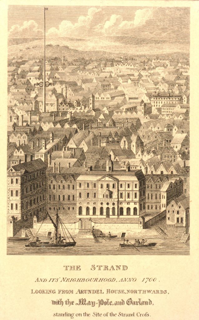
There seems to have been three maypoles on this same site – the first of which was standing before the destruction of Strand’s ancient cross, where local jurisdictions and early village meetings took place.  We don’t know the date when the first maypole was erected, but it was shown on a local plan of the area “which Anthony van den Wyngaerde issued in 1543…in front of the old church of St. Mary le Strand, which was demolished in 1549.”   According to Mr Hone (1826), it could be found a door or two westward beyond “where Catherine Street descends into the Strand.”

In Edward Walford’s (1878) massive tome, he gave us perhaps the best and most extensive account of the site, telling:

“The Maypole, to which we have already referred as formerly standing on the site of the church of St. Mary-le-Strand, was called by the Puritans one of the “last remnants of vile heathenism, round which people in holiday times used to dance, quite ignorant of its original intent and meaning.” Each May morning, as our readers are doubtless aware, it was customary to deck these poles with wreaths of flowers, round which the people danced pretty nearly the whole day.  A severe blow was given to these merry-makings by the Puritans, and in 1644 a Parliamentary ordinance swept them all away, including this very famous one, which, according to old Stow, stood 100 feet high.

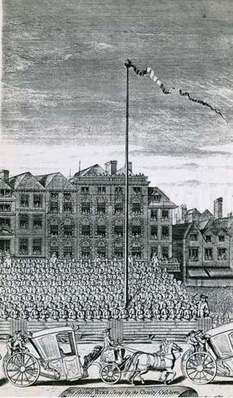
On the Restoration, however, a new and loftier one was set up amid much ceremony and rejoicing. From a tract printed at the time, entitled The Citie’s Loyaltie Displayed,’ we learn that this Maypole was 134 feet high, and was erected upon the cost of the parishioners there adjacent, and the gracious consent of his sacred Majesty, with the illustrious Prince the Duke of York:

“This tree was a most choice and remarkable piece; ’twas made below bridge and brought in two parts up to Scotland Yard, near the king’s palace, and from thence it was conveyed, April 14, 1661, to the Strand, to be erected. It was brought with a streamer flourishing before it, drums beating all the way, and other sorts of musick.  It was supposed to be so long that landsmen could not possibly raise it.  Prince James, Duke of York, Lord High Admiral of England, commanded twelve seamen off aboard ship to come and officiate the business; whereupon they came, and brought their cables, pullies, and other tackling, and six great anchors. After these were brought three crowns, borne by three men bareheaded, and a streamer displaying all the way before them, drums beating and other musick playing, numerous multitudes of people thronging the streets, with great shouts and acclamations, all day long. The Maypole then being joined together and looped about with bands of iron, the crown and cane, with the king’s arms richly gilded, was placed on the head of it; a large hoop, like a balcony, was about the middle of it.  Then, amid sounds of trumpets and drums, and loud cheerings, and the shouts of the people, the Maypole, ‘far more glorious, bigger, and higher than ever any one that stood before it,’ was raised upright, which highly did please the Merrie Monarch and the illustrious Prince, Duke of York; and the little children did much rejoice, and ancient people did clap their hands, saying golden days began to appear.”

A party of morris-dancers now came forward, “finely decked with purple scarfs, in their half-shirts, with a tabor and a pipe, the ancient music, and danced round about the Maypole.”

The setting up of this Maypole is said to have been the deed of a blacksmith, John Clarges, who lived hard by, and whose daughter Anne had been so fortunate in her matrimonial career as to secure for her husband no less a celebrated person than General Monk, Duke of Albemarle, in the reign of Charles II., when courtiers and princes did not always look to the highest rank for their wives.

…Newcastle Street, at the north-east corner of the church of St. Mary-le-Strand, was formerly called Maypole Alley, but early in the last century was changed to its present name, after John Holles, Duke of Newcastle, the then owner of the property, and the name has been transferred to another place not far off. At the junction of Drury Lane and Wych Street, on the north side, close to the Olympic Theatre, is a narrow court, which is now known as Maypole Alley, near which stood the forge of John Clarges, the blacksmith, alluded to above as having set up the Maypole at the time of the Restoration.

As all earthly glories are doomed in time to fade, so this gaily-bedecked Maypole, after standing for upwards of fifty years, had become so decayed in the ground, that it was deemed necessary to replace it by a new one.  Accordingly, it was removed in 1713, and a new one erected in its place a little further to the west, nearly opposite to Somerset House, where now stands a drinking fountain.  It was set up on the 4th of July in that year, with great joy and festivity, but it was destined to be short-lived. When this latter Maypole was taken down in its turn, Sir Isaac Newton, who lived near Leicester Fields, bought it from the parishioners, and sent it as a present to his friend, the Rev. Mr. Pound, at Wanstead in Essex, who obtained leave from his squire, Lord Castlemaine, to erect it in Wanstead Park, for the support of what then was the largest telescope in Europe, being 125 feet in length.  It was constructed by Huygens, and presented by him to the Royal Society, of which he was a member. It had not long stood in the park, when one morning some amusing verses were found affixed to the Maypole, alluding to its change of position and employment. They are given by Pennant as follows:

“Once I adorned the Strand,
But now have found
My way to Pound
On Baron Newton’s land;
Where my aspiring head aloft is reared,
T’ observe the motions of th’ ethereal Lord.
Here sometimes raised a machine by my side,
Through which is seen the sparkling milky tide;
Here oft I’m scented with a balmy dew,
A pleasant blessing which the Strand ne’er knew.
There stood I only to receive abuse,
But here converted to a nobler use;
So that with me all passengers will say,
‘I’m better far than when the Pole of May.'”

Along with the Strand Cross, this old maypole would have been on the ancient ley (not one of those ‘energy lines’ invented by New Age fantasists) that was first described first by Alfred Watkins (1925)—running from St. Martins-in-the-Field to St. Dunstan’s in Fleet Street. The alignment and maypole was subsequently described in greater detail in Devereux & Thomson’s (1979) work on the same subject, and again by Chris Street. (2010)

The nature of the maypole (and the nearby cross, it has to be said), may have been representative of an omphalos in early popular culture (before the christians of course)—which would put the original ritual function of the place far far earlier than is generally considered.  This is something that Laurence Gomme (1912) propounded in one of his London works and cannot be discounted.

References:

  1. Allen, Thomas, The History and Antiquities of London, Westminster, Southwark – volume 4, Cowie & Strange: London 1829.
  2. Devereux, Paul & Thomson, Ian, The Ley Hunter’s Companion, Thames & Hudson: London 1979.
  3. Eliade, Mircea, Patterns in Comparative Religion, Sheed & Ward: London 1958.
  4. Gomme, Laurence, The Making of London, Clarendon: Oxford 1912.
  5. Hone, William, The Every-Day Book – volume 1, William Tegg: London 1826.
  6. Street, Christopher E., London’s Ley Lines, Earthstars: London 2010.
  7. Walford, Edward, Old and New London – volume 3, Cassell, Petter & Galpin, London, 1878.
  8. Watkins, Alfred, The Old Straight Track, Methuen: London 1925.
  9. Wright, A.R., British Calendar Customs: England – volume 2, Folklore Society: London 1938.

© Paul BennettThe Northern Antiquarian 


An Sithean, Lawers, Kenmore, Perthshire

Legendary Hill:  OS Grid Reference – NN 6806 3976

Getting Here

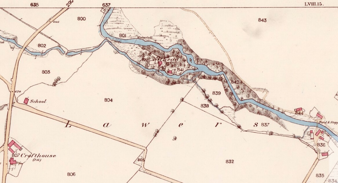
An Sithean on 1862 OS-map

Take the A827 road on the north-side of Loch Tay between Killin and Kenmore, and roughly halfway along you’ll find the tiny hamlet of Lawers.  Go down into the hamlet itself and, amidst the remains of the old trees where now are houses, nestled on a rise in the land with burns (streams) on either side, remains of the fairy mound of An Sithean still lives…

Folklore

Remnants of the legends of little people are legion in the Scottish mountains.  Sadly, many of them died when the English arrived and culled the population in ‘The Clearances’ of the 19th century – none moreso than in the area surrounding Loch Tay.  But thankfully, in the latter-half of the 19th century, a local man called James MacDiarmid (1910), took it upon himself to write down many of the old stories told by the remaining locals – as well as narrate those he remembered as a boy, as told by the elders around him.  Whilst tales of ‘fairies’ and other such creatures are thought by city-minds to be little other than fantasies, mountain-folk cosmologies differ greatly to those who are disconnected from the natural world.  Genius loci abound, and animism is the basic plinth integral to communities in the hills, where the world is much much more real.  This is one such tale…

“Not many years ago there lived in the neighbourhood of Killin a man who was in the habit of recounting his wonderful adventures with the white horse of the fairies.  When coming home one night from Kenmore market, and just as he was passing Sithean, Lawers, he heard most enchanting music proceeding from the knoll.  Unable to resist the temptation, he gradually went nearer and nearer the fairies’ place of abode, till at last he was fairly among them.  They received him most kindly, and on parting gave him one of their white horses to carry him home.  His steed went through the air at a speed almost equalling that of lightning, and in a few minutes he found himself above a house at Clifton, Tyndrum, some twenty-five miles westward from Lawers.  Happening to shout “ho!” when he was right above the chimney, the fairy horse threw him off its back, and down he dropped feet foremost through the wide, old-fashioned chimney, and alighted in the midst of a wedding party, much to their surprise and alarm. He continued in their pleasant company till daylight, when he returned home at his leisure, thanking the fairies for the pleasure they had so unexpectedly given him!”

Usually, tales such as this relate to the existence of prehistoric cairns or tumuli (burial sites), but no such archaeological remains have ever been known to live here.  Equally curious is how the man in this tale wasn’t kept in the timeless realms, beloved of faerie-land, where reveries with them would take decades from a man’s life, even though it only felt like one night.  This would imply

I’ve come across old locals who still speak, not just of the little-folk, but of other hauntings in this beautiful part of Loch Tay.  May the land not be cursed by the fools who put their idea of ‘development’ in front of the genius loci here; lest madness and ill-fortune will prevail…

References:

  1. MacDiarmid, James, “More Fragments of Breadalbane Folklore,” in Transactions of the Gaelic Society Inverness, volume 26, 1910.

© Paul Bennett, The Northern Antiquarian


Holy Well, Didsbury, Manchester, Lancashire

Holy Well (destroyed?):  OS Grid Reference — SJ 8464 9036

Archaeology & History

In Henry Taylor’s gigantic survey on the Ancient Crosses and Holy Wells of Lancashire (1906), he told that “records of the existence of holy wells in this (district) are scanty in the extreme.”  Indeed.  He certainly missed this one which, it seems (if modern lore is correct), has sadly fallen prey to that sickness which those ghastly people call ‘progress’.  Cited to have been in or near the old graveyard of St. James church in the old village, this once ever-flowing spring of water was of great repute in earlier centuries, not only for general health, magick and traditions, but also supposedly in prolonging life itself!

One of the standard historians of Didsbury, Mr Fletcher Moss (1898), was of the view that this Well may have been the “origin of Didsbury, the place the Saxon settlers would choose first for their church and community.”  He may be right.  He told that,

“It was said ‘to be holy in papist times.’  Only last summer I several times saw three young ladies who came every morning to bathe their eyes and faces in it, saying, “It was good for sore eyes.”  I could not see anything the matter with their eyes, but that may have been my ignorance, or that they were already getting better. In the spring time or early in May the well has often been nearly choked with wild flowers, and pins have been put in for luck.  If rags or crutches were ever left there, it was when the water bubbled up in the roadway on the hillside.  The flow of it is lessened by drains or sewers, and now it is taken down in pipes.  The lane is enclosed with brick walls, and all the romance is gone; but in the longest drought or severest frost the water from the holy well has never failed, and though it may come from the churchyard, we and many others drink no other.”

In an earlier passage (Moss 1891), he talked about the longevity and good health of the local people and who credited the good water here:

“Like most of the old Didsbury folk who never bothered with doctors or change of air, Sam Gaskill, the last clerk, lived to be long past the fourscore years, for I remember him and others much older than he was, regularly going to the Holy Well for the water for their households.  As in patriarchal and primitive times the villagers went to the well or spring at eventide and tarried and talked while the water flowed.  It mattered nought to them that the water flowed from the churchyard, from the burial-place of their forefathers; they had always been healthy as their forefathers had been healthy, and they wanted no other water and would have no other; that always bubbled up fresh and sparkling in summer or winter, in drought or frost, and never failed.”

Nearby to the east, spirits of the dead were said to come from the old trees of Parrs Wood, long since destroyed by those self-righteous Industrialists…

References:

  1. Million, Ivor R., A History of Didsbury, E. J. Morten 1969
  2. Moss, Fletcher, Didisburye in the ’45, Cornish: Manchester 1891.
  3. Moss, Fletcher, Folklore, Old Customs and Tales of My Neighbours, privately printed: Manchester 1898.

Acknowledgements:  With big thanks to Bret Gaunt, Paul Hornby and Geraldine Dowsing for their input.

© Paul BennettThe Northern Antiquarian 


Ancient & Holy Wells of Edinburgh

Ancient & Holy Wells of Edinburgh

by

Paul Bennett

Northern Antiquarian: Alva 2017.  Kindle edition – 123 pages. 

Price – £3.99

This is the first detailed guide ever written on the holy wells and healing springs in and around the ancient city of Edinburgh, Scotland. Written in a simple A-Z gazetteer style, nearly 70 individual sites are described, each with their grid-reference location, history, folklore and medicinal properties where known. Although a number them have long since fallen prey to the expanse of Industrialism, many sites can still be visited by the modern historian, pilgrim, christian, pagan or tourist.

The book opens with two introductory chapters: the first explores the origin and nature of holy wells and what they meant to local people in earlier centuries; and the next is a comparative overview of water cults worldwide. It is an invaluable guide for any student or tourist who wants to look beneath the modern history of the city and get a taste of the more archaic customs that once belonged here…