Askwith Moor Carving 515, North Yorkshire

Cup-Marked Stone:  OS Grid Reference – SE 1668 5056

Also Known as:

  1. Shooting House West carving 

Getting Here

From Askwith village, at the T-junction, go up Moor Lane, taking the left turn up Moorside Lane about half-a-mile up and on the track to Moorside Farm and then onto Top Moorside Farm.  Take the path past the farm up onto the moor, then bear right up the small track that heads up onto the small Hollin Tree Hill.  As you go up the track, watch out for the small grassy depression to the right; and hereby head into the grasses on your right.  You’re close!

Archaeology & History
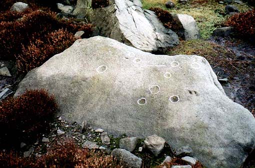
Image © Graeme Chappell
Image © Richard Stroud

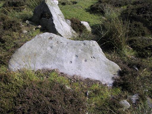
Graeme Chappell was the first to rediscover this carving in the early 1990s when we were up pottering about on these and the adjacent moors, looking for any previously undiscovered prehistoric relics.   We found quite a lot!  The carving here is nowt special to look at really, but the cups can be seen quite clearly.  It’s a rather large stone on the western edge of the hill with at least seven or eight cup-marks carved across its upper surface.  Boughey & Vickerman (2003) later described it as “large, fine quartz sandstone rock with surface sloping slightly down into (the) hillside.  Seven or eight cups, two particularly sharp.”  There’s a possible line running between two of the cups, visible when lighting conditions are right — though we aint sure whether it’s artificial or not.

References:

  1. Boughey, Keith & Vickerman, E.A., Prehistoric Rock Art of the West Riding, WYAS 2003.

© Paul Bennett, The Northern Antiquarian

Askwith Moor (521), North Yorkshire

Cup-Marked Stone:  OS Grid Reference – SE 17162 50530

Also Known as:

  1. Round Rock

Getting Here

To find this, head for the line of old grouse-butts which run north-south, a few hundred yards west of the Askwith Moor Road. Just before y’ get to the one nearest the bottom of the line, frobble about a bit.  If by any chance you end up at the Woman Stone carving, walk back up the slope until you’re on the level.  Not far ahead of you are the upright stone remains of a grouse-butt.  This carving is just a few yards away.  You’ll find it.

Archaeology & History

Image © Richard Stroud

This was another carving found on one of the many forays of Mr Chappell and I when we were young, sometime in 1993.   A short while after, Graeme wrote to Edward Vickerman to inform him of the find, which ended up in their rock art survey a decade later.

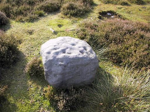
It’s another one of those simple designs: what seems like at least 5 cup-markings on a small rounded rock, with two of them linked together by a groove — possibly natural, possibly man-made — though there may in fact be seven or more cups etched onto its upper surface.  It’s difficult to tell.  It gives you the impression that its present position isn’t its original one and is suggested by Boughey & Vickerman (2003) to have been “moved from pipeline?” close by.  It may even have been dug out and cast here, possibly once being a part of a cairn.  In the Boughey & Vickerman survey they give its OS-coordinate as SE 17163 50527 – and describe it as a “medium-sized, free-standing rock of fine grit. Five cups, some perhaps natural.”  When Richard Stroud and I visited the site, he found the GPS coordinate was SE 17162 50530; and we have to say that instead of describing it as a free-standing rock, it’s a movable stone (though it’d take a bit of effort), that may once have been part of a larger monument.

References:

  1. Bennett, Paul & Chappell, Graeme, Personal Communication, 1993.
  2. Boughey, Keith & Vickerman, E.A., Prehistoric Rock Art of the West Riding, WYAS: Wakefield 2003.

© Paul Bennett, The Northern Antiquarian