Dome Rock, St Fillans, Comrie, Perthshire

Cup-and-Ring Stone:  OS Grid Reference – NN 67511 25028

Getting Here

Dome Rock

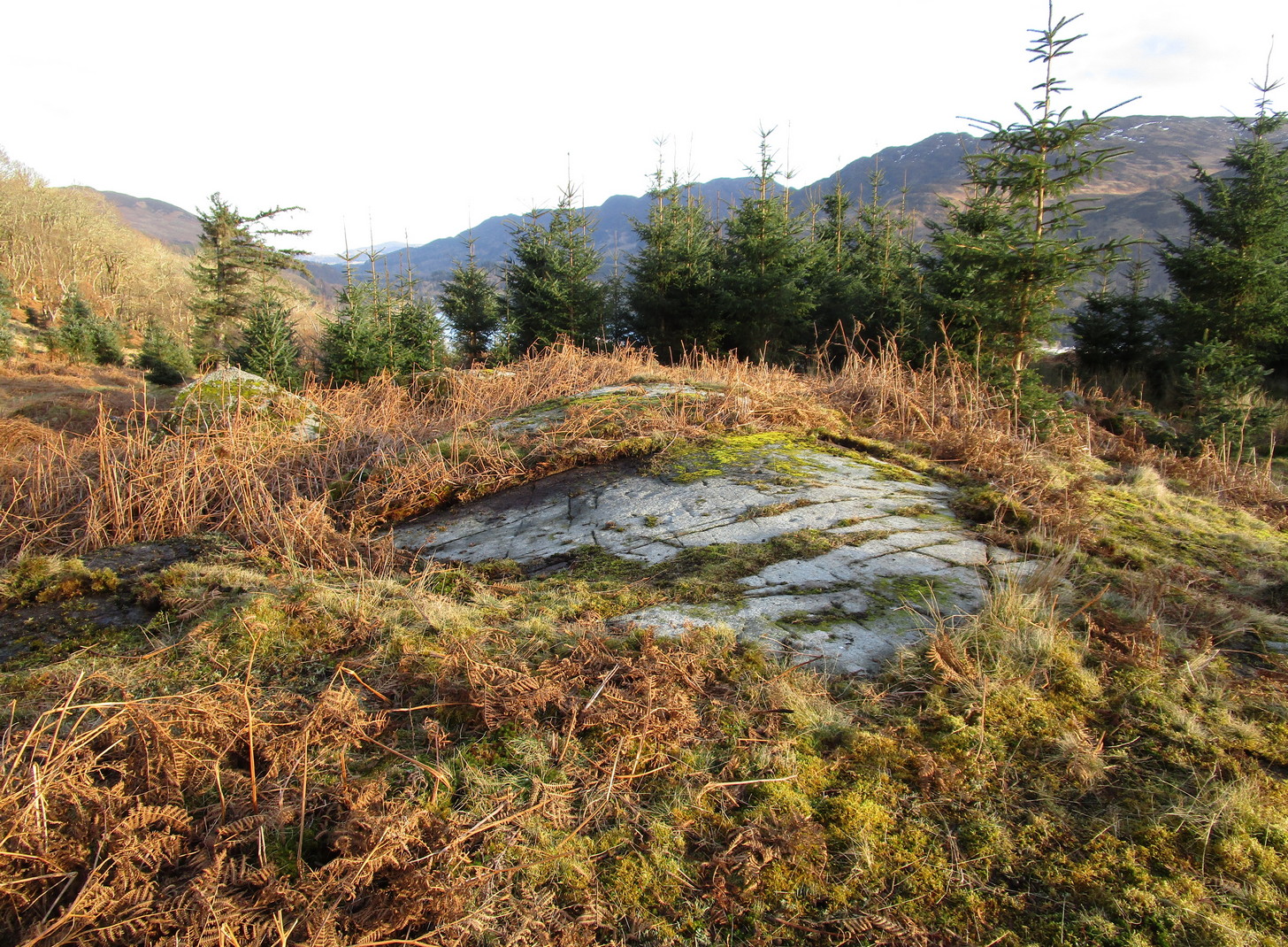
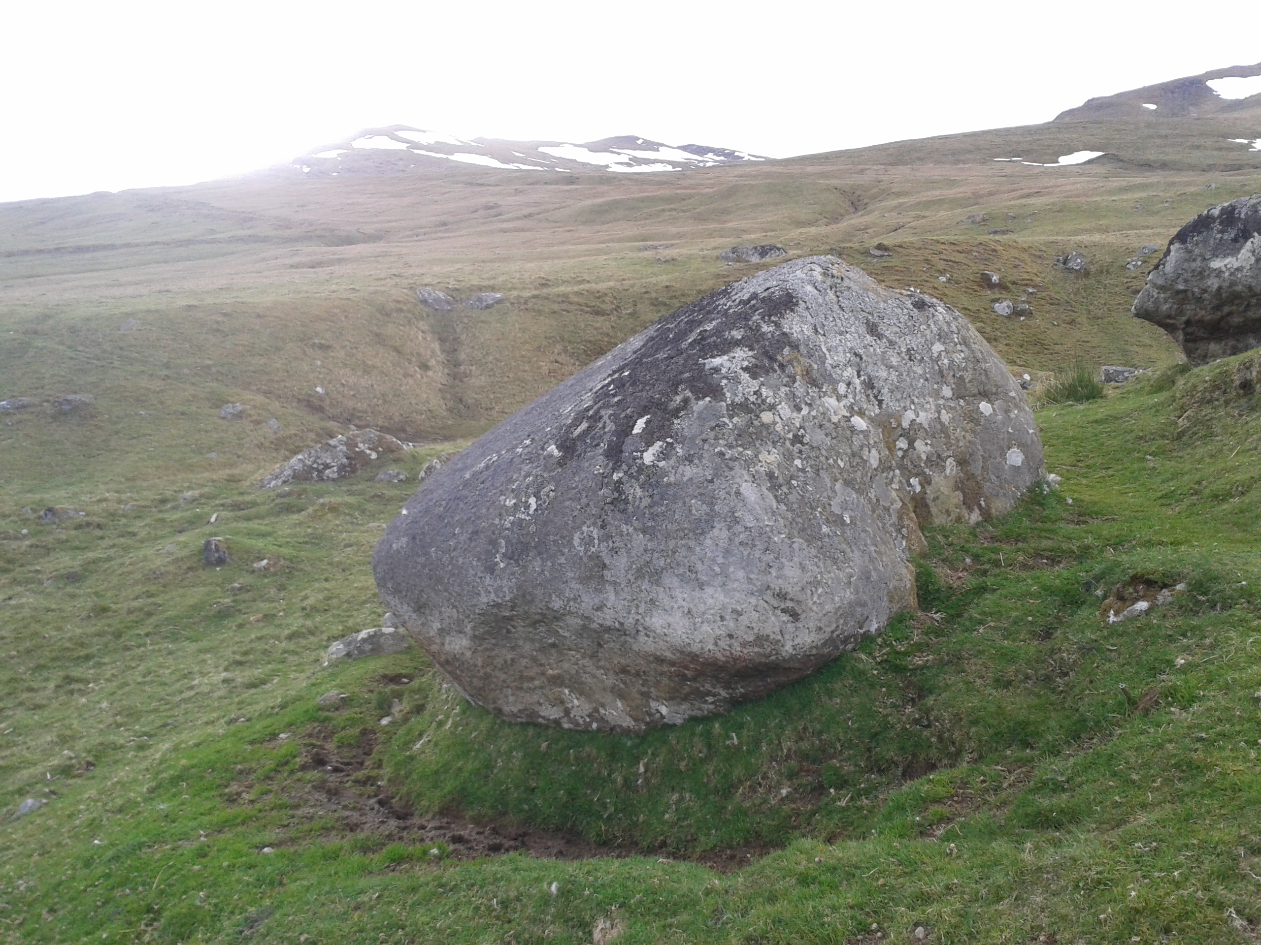
On the A85 road from St Fillans to Lochearnhead, about 1½ miles on is the Loch Earn Sailing Club, with a large parking spot thereby.  From here, cross the road and go through the gate up the dirt-track, past the cottages where the track bends right until a few hundred yards further up where the track splits, bear right, along and down across the river, up the other side and past the cottage.  From here, the track becomes a grassy footpath.  Walk along here, east towards the trees 5-600 yards away.  Once you go through the large wooden slip-gate, about 150 yards on the path into the scattered trees, you’ll see a large dome-shaped rise on your right (south).  Y’ can’t really miss it!

Archaeology & History

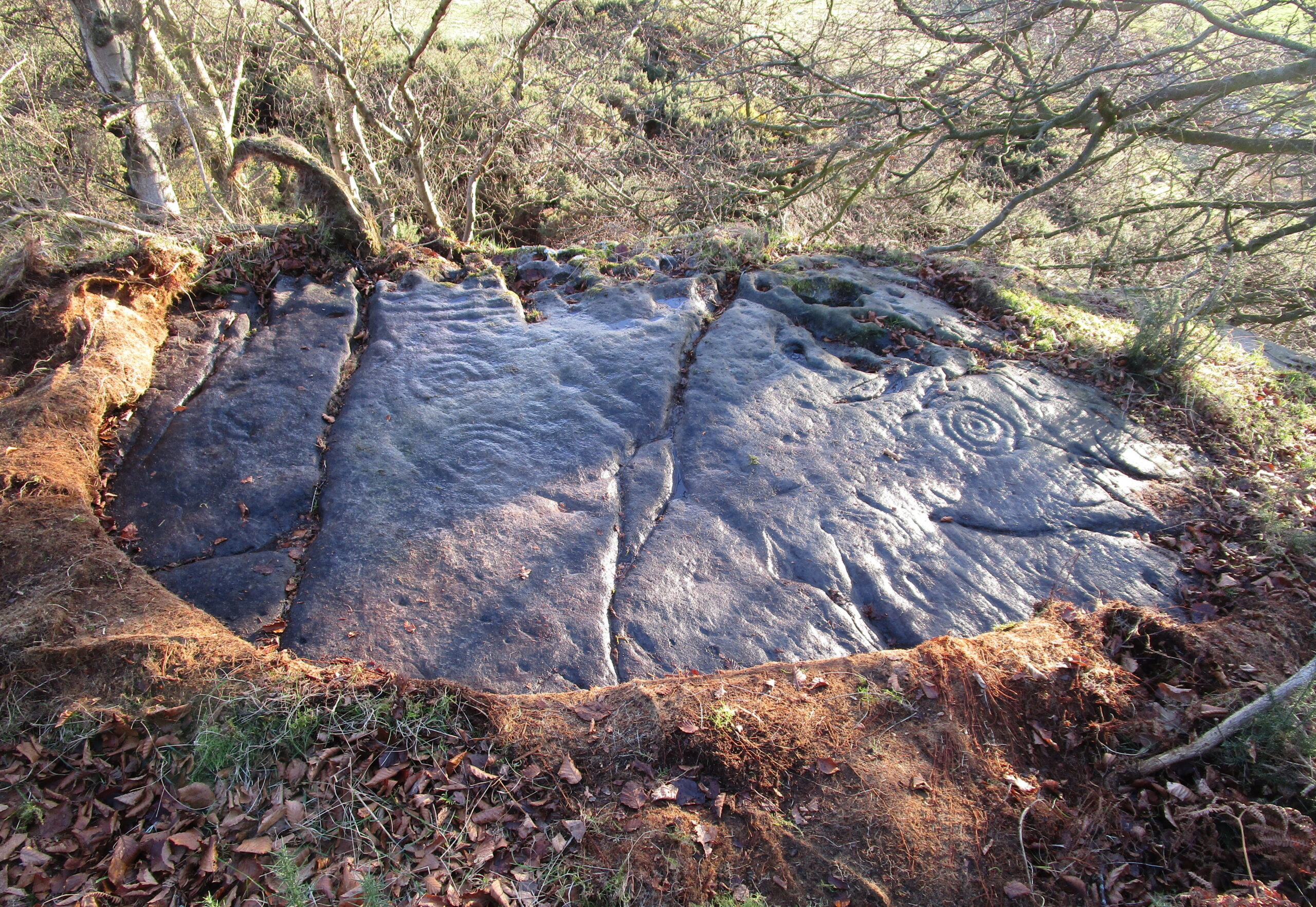
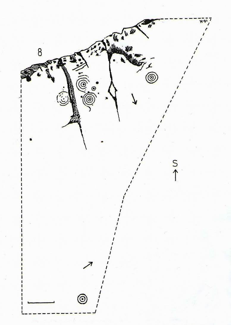
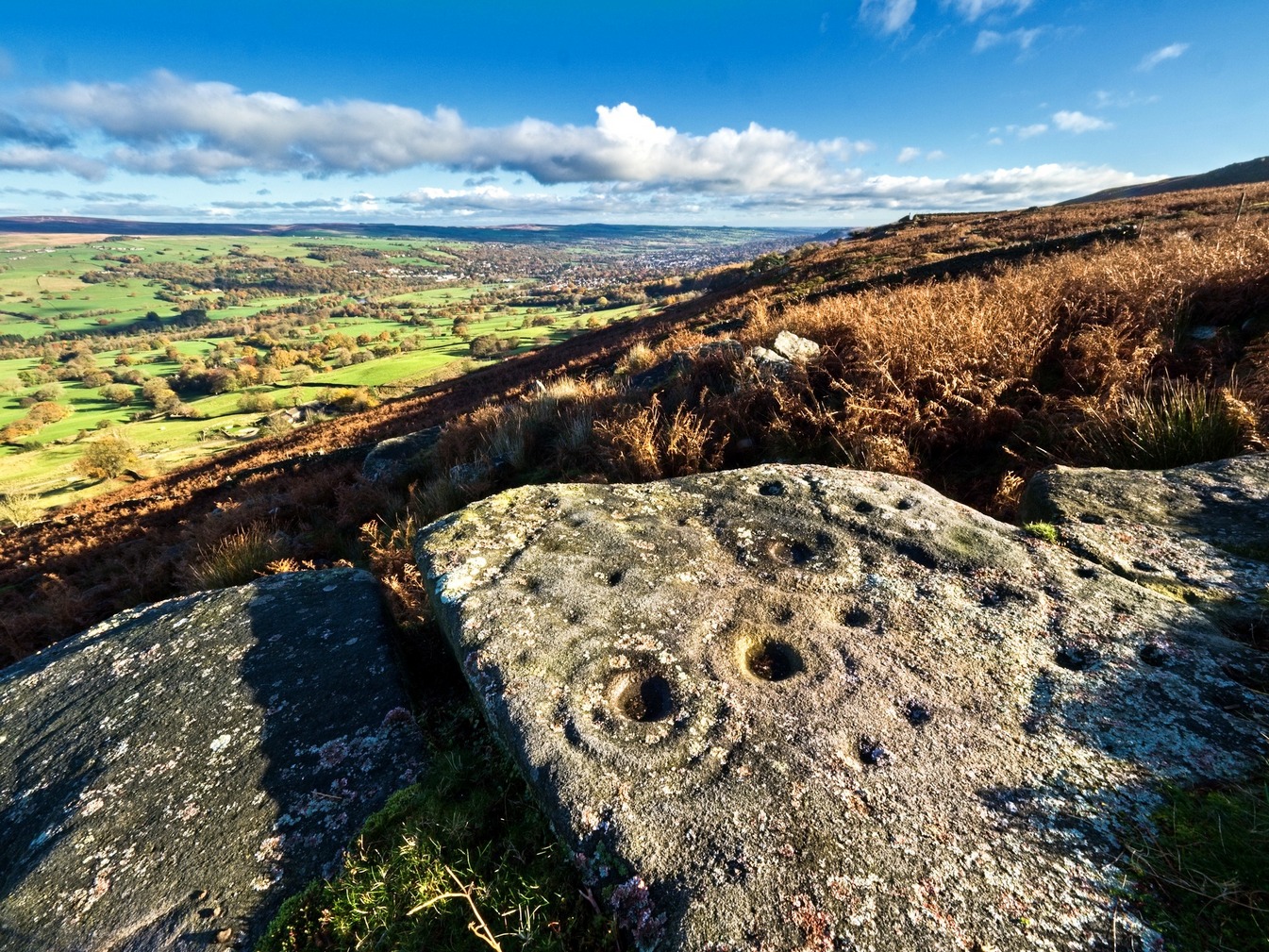
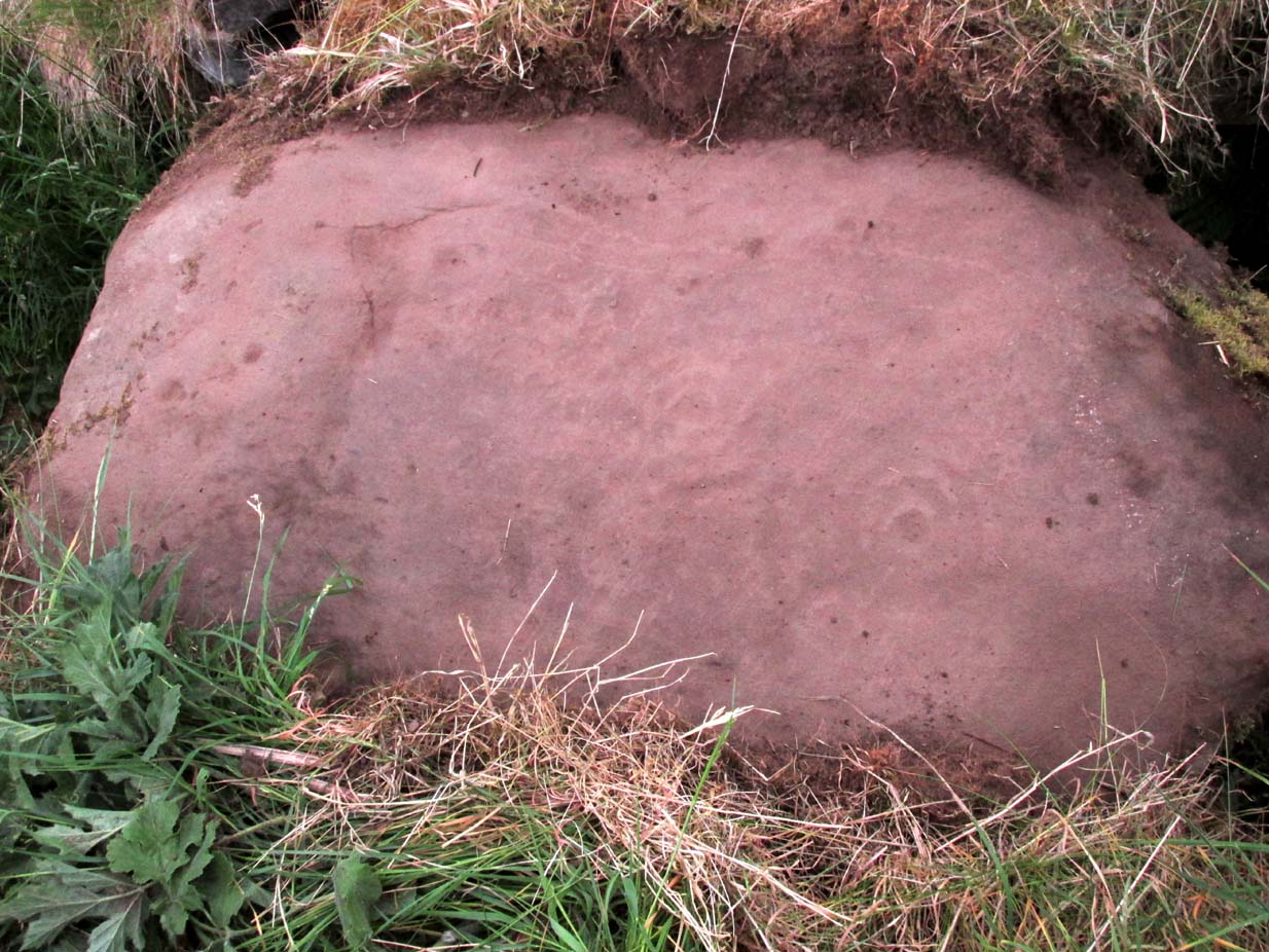
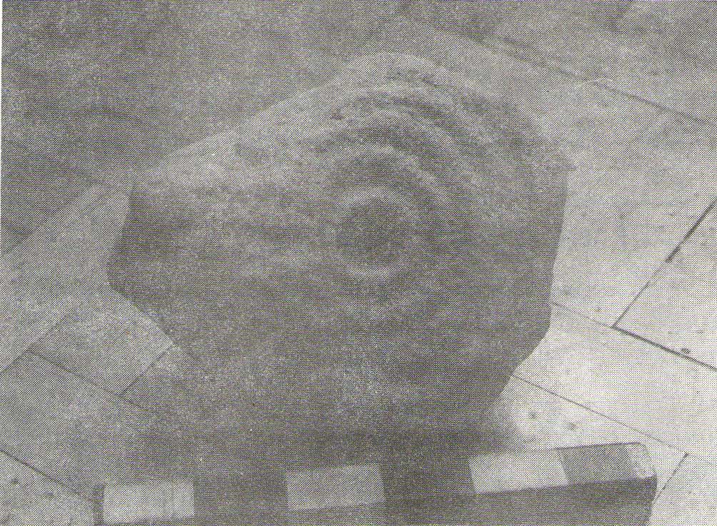
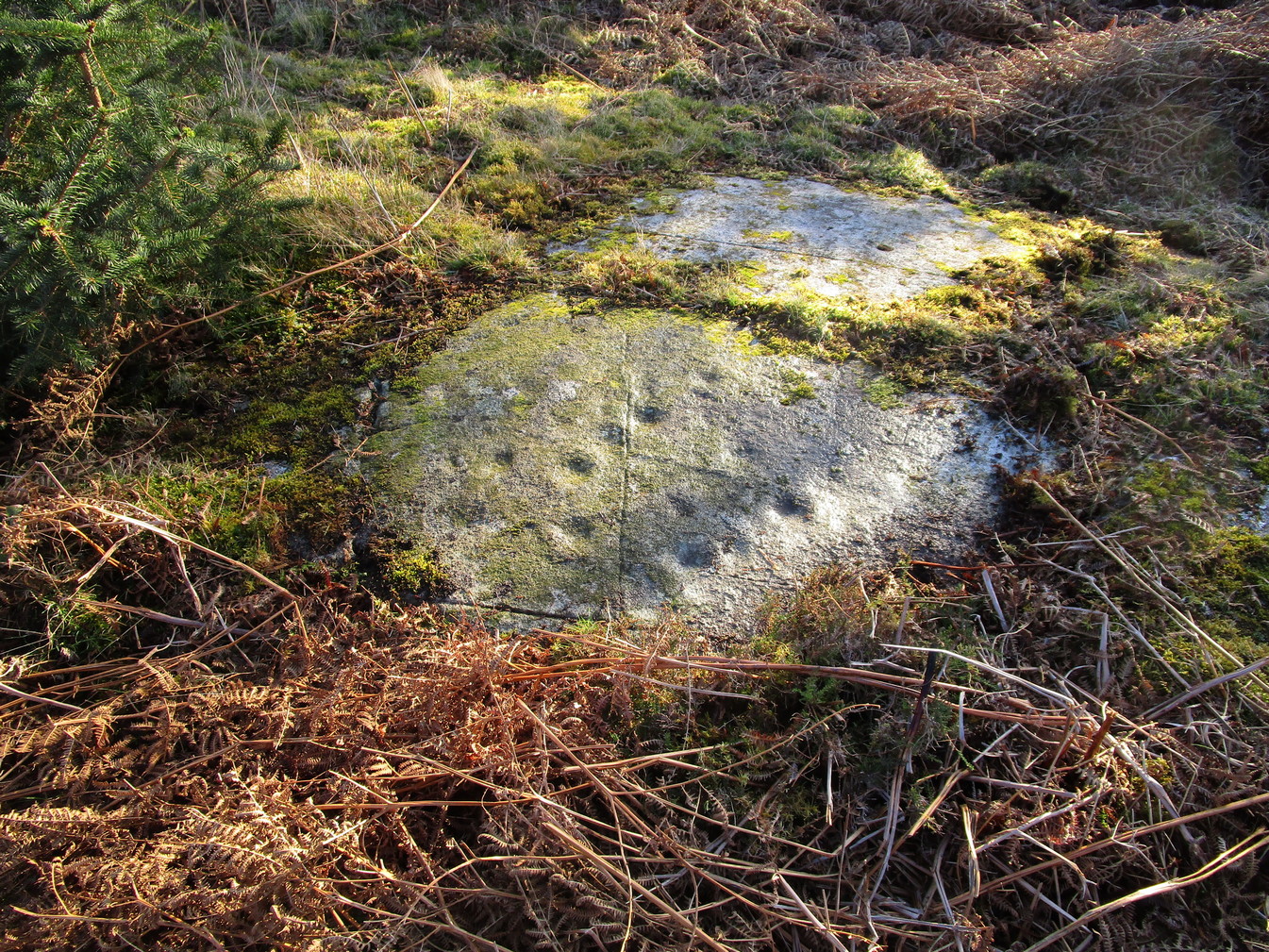
This carving was rediscovered by the great Scottish petroglyph writer Ron Morris in 1968.  He told that, just below the overgrown track, “is a big dome-shaped outcrop with a smooth top.  On a scattered area on this, in 3 main groups, are over 24 cup-marks, up to 3″ diameter, ½” deep.”  But these aren’t mere cup-marks…

Faint, albeit clear cup-and-rings
Cup-marks, top & bottom of photo

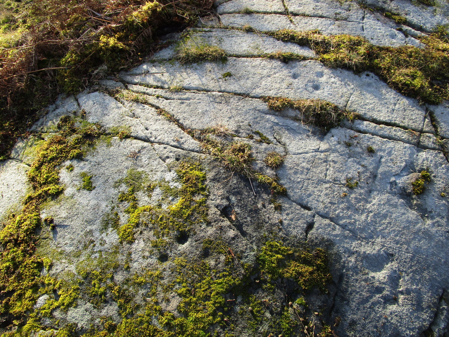
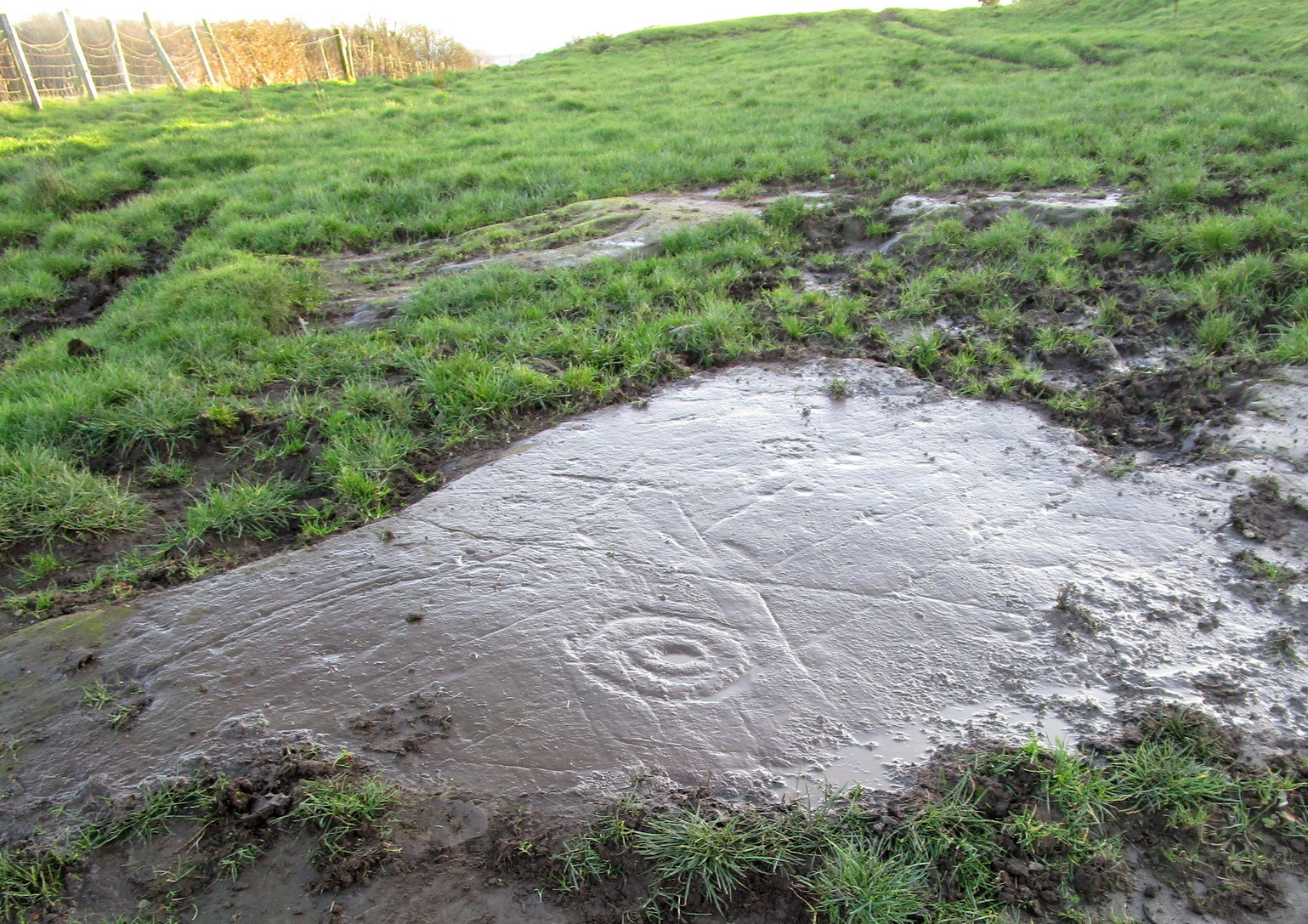
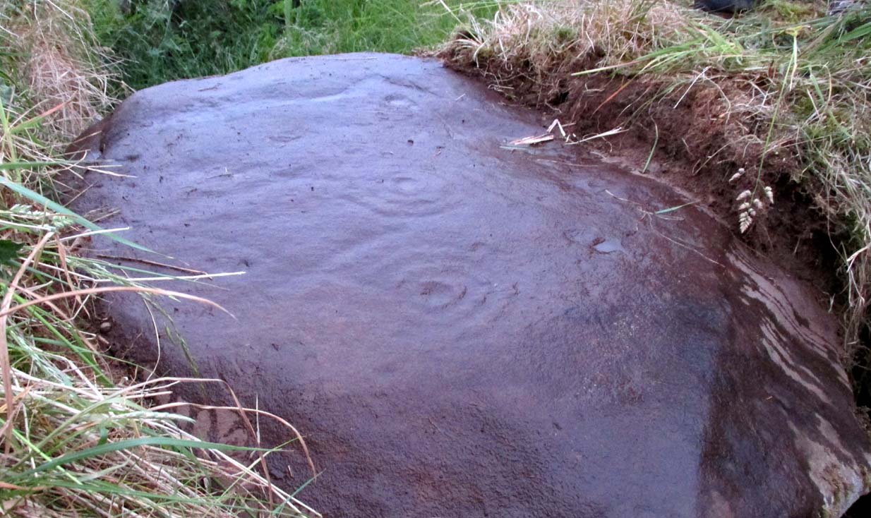
It literally is just like a large dome of rock, with carvings on certain sections of it.  Half of the cup-marks are easy to see, especially the ones near to the top of the dome and which exist in three main clusters.  Much more faint is another, larger cluster of cups, on its south-side.

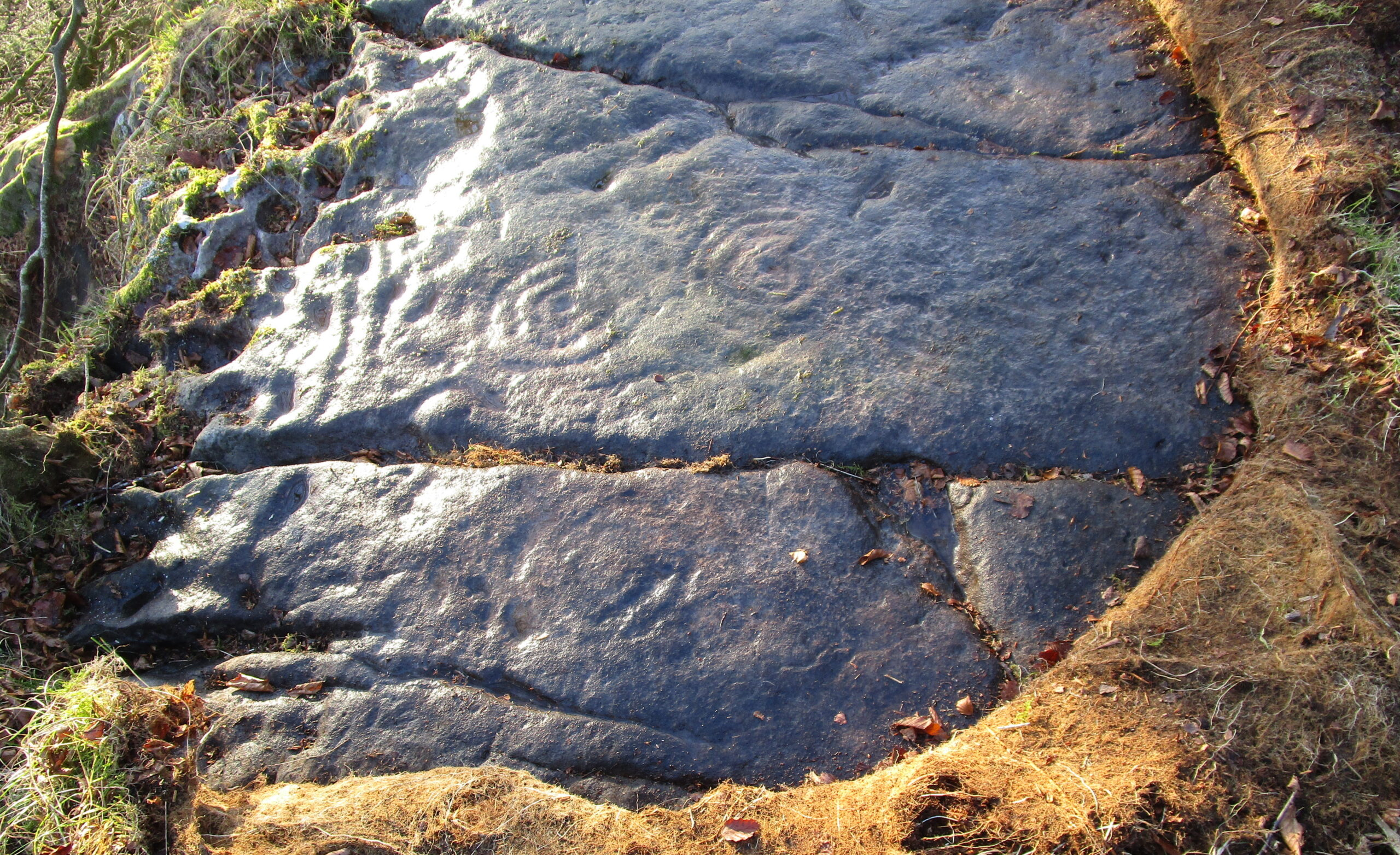
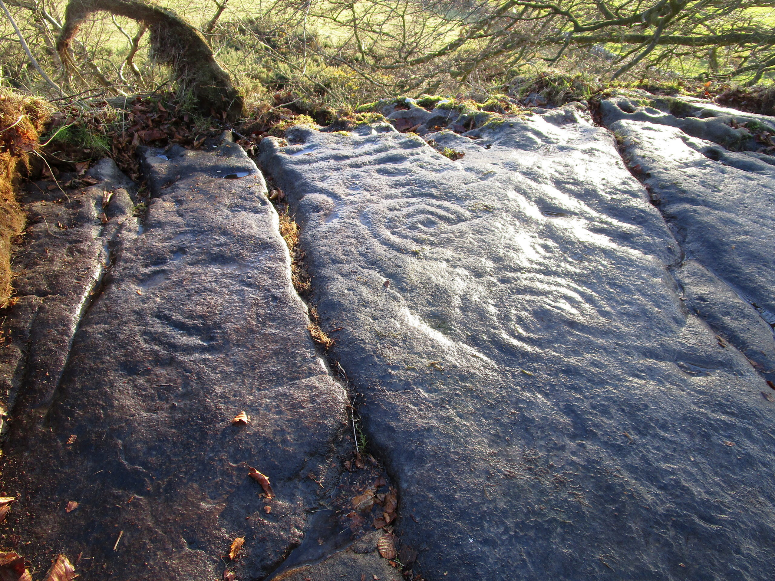
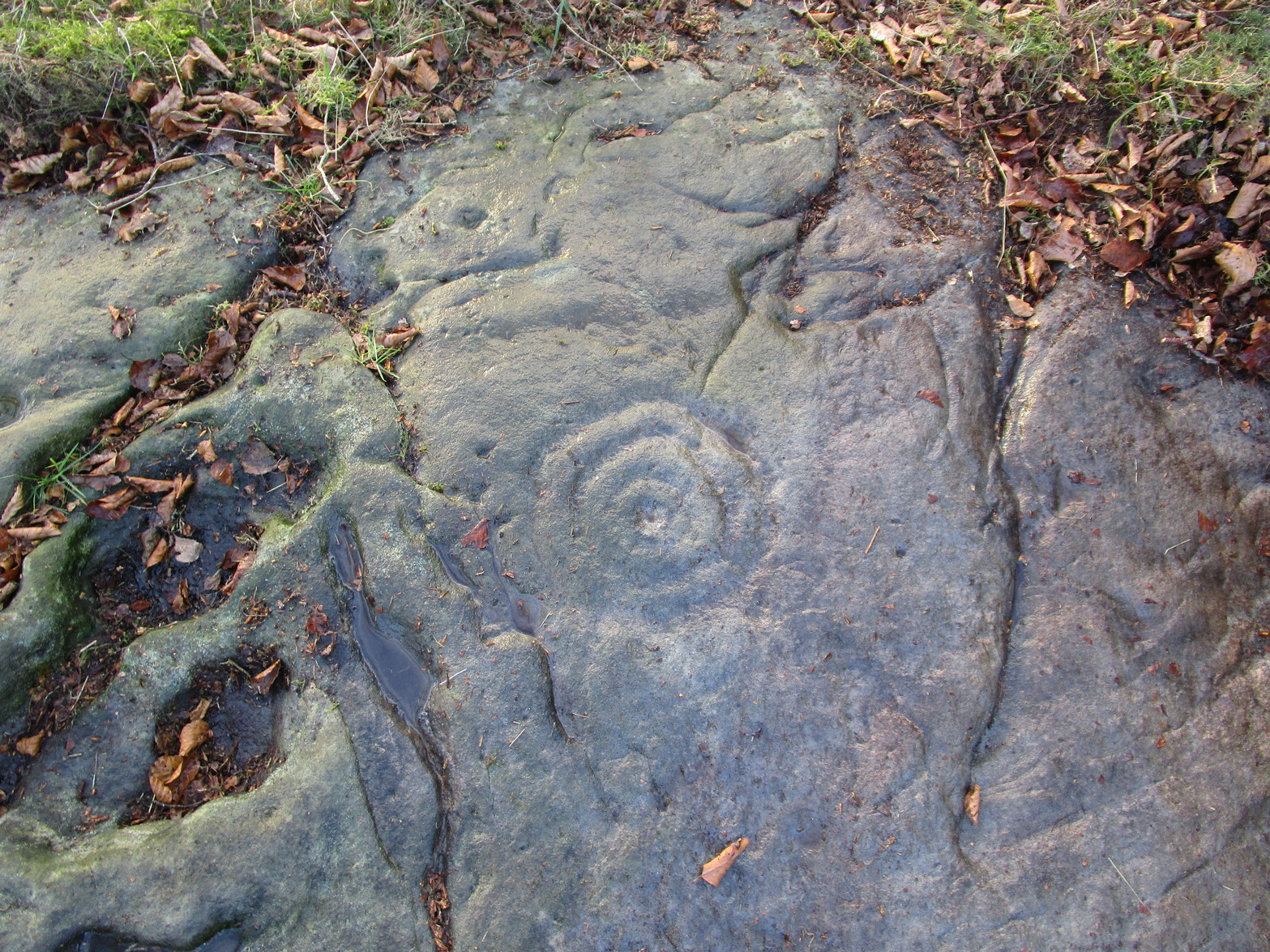
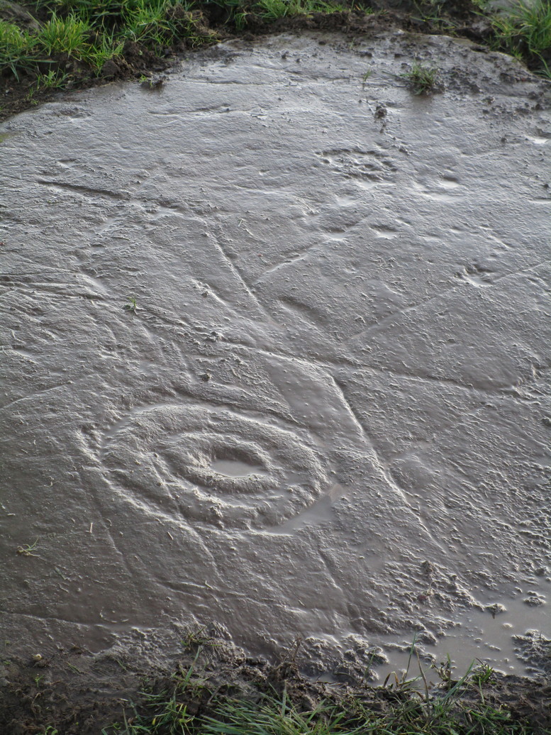
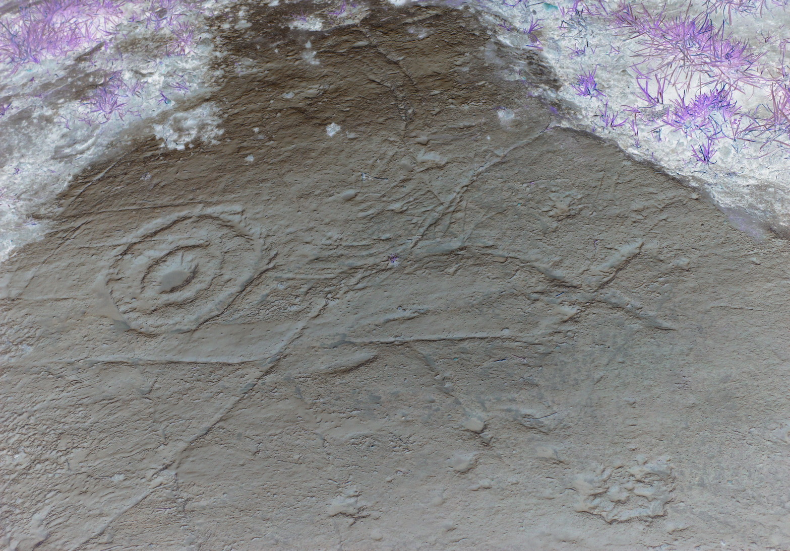
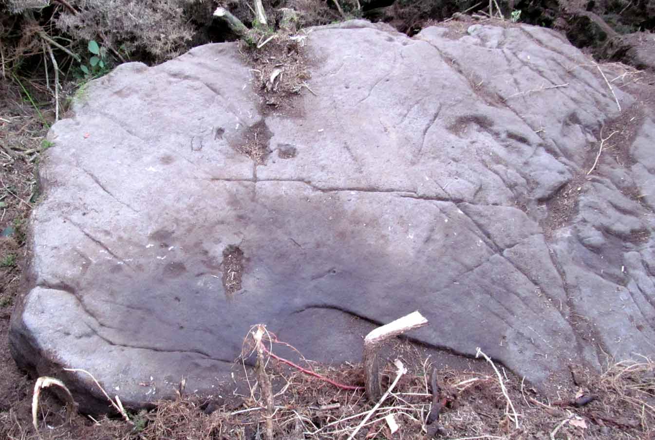
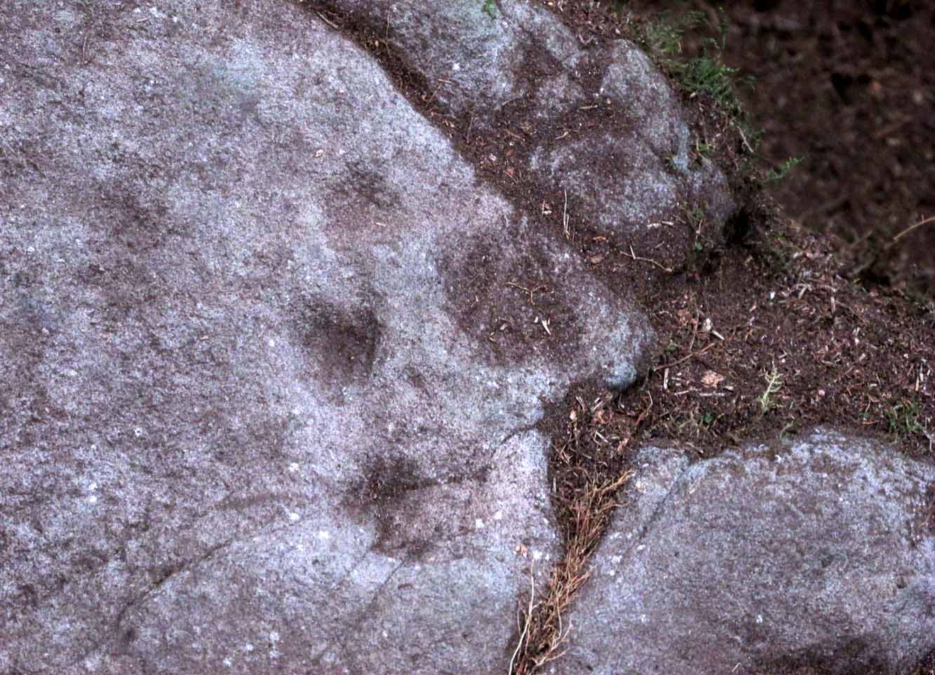
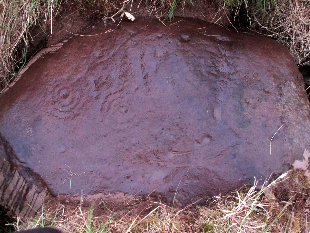
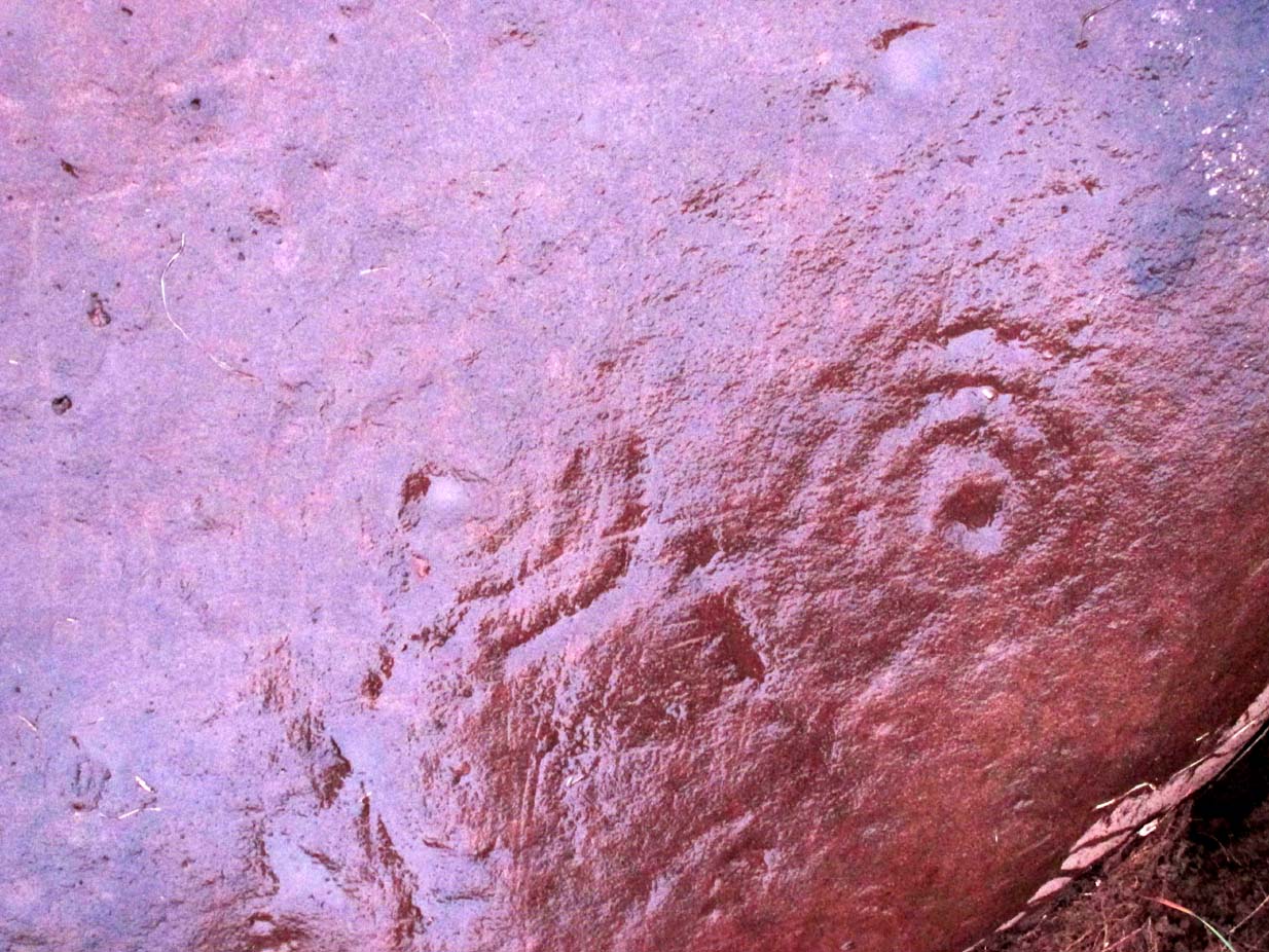
Dealing with those on top of the rock: on the easternmost side a long natural crack separates a faint single cup-mark from a notable triangle of three, clearly visible in the photo (left).  Below this are what may be a couple more cups, but they were difficult to make out and may simply be Nature’s handiwork.  Certainly Nature has a part to play in the next small cluster of cups about six-feet further along the stone.  A shallow natural ‘arc’ has clearly been used to create a ring around one of the cups, clearly visible in the photo (right), with another faint cup-and-ring visible below it.  In between these, both Paul Hornby and I could make out what may be another incredibly faint smaller cup-and-ring (and which seemed evident on a couple of photos), but we need to wait for the computer-tech boys to get their teeth into that one!  Several other single cup-marks exist either side of another moss-covered crack in the rock.  And as we roll over the top western-edge of the stone, another small cluster of three, maybe four single cup-marks greets our attention.

Close-up of southern C&Rs
Southern carved section

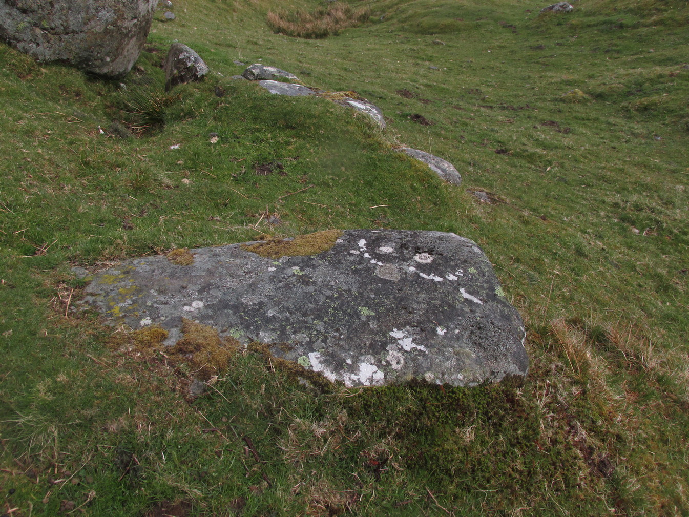
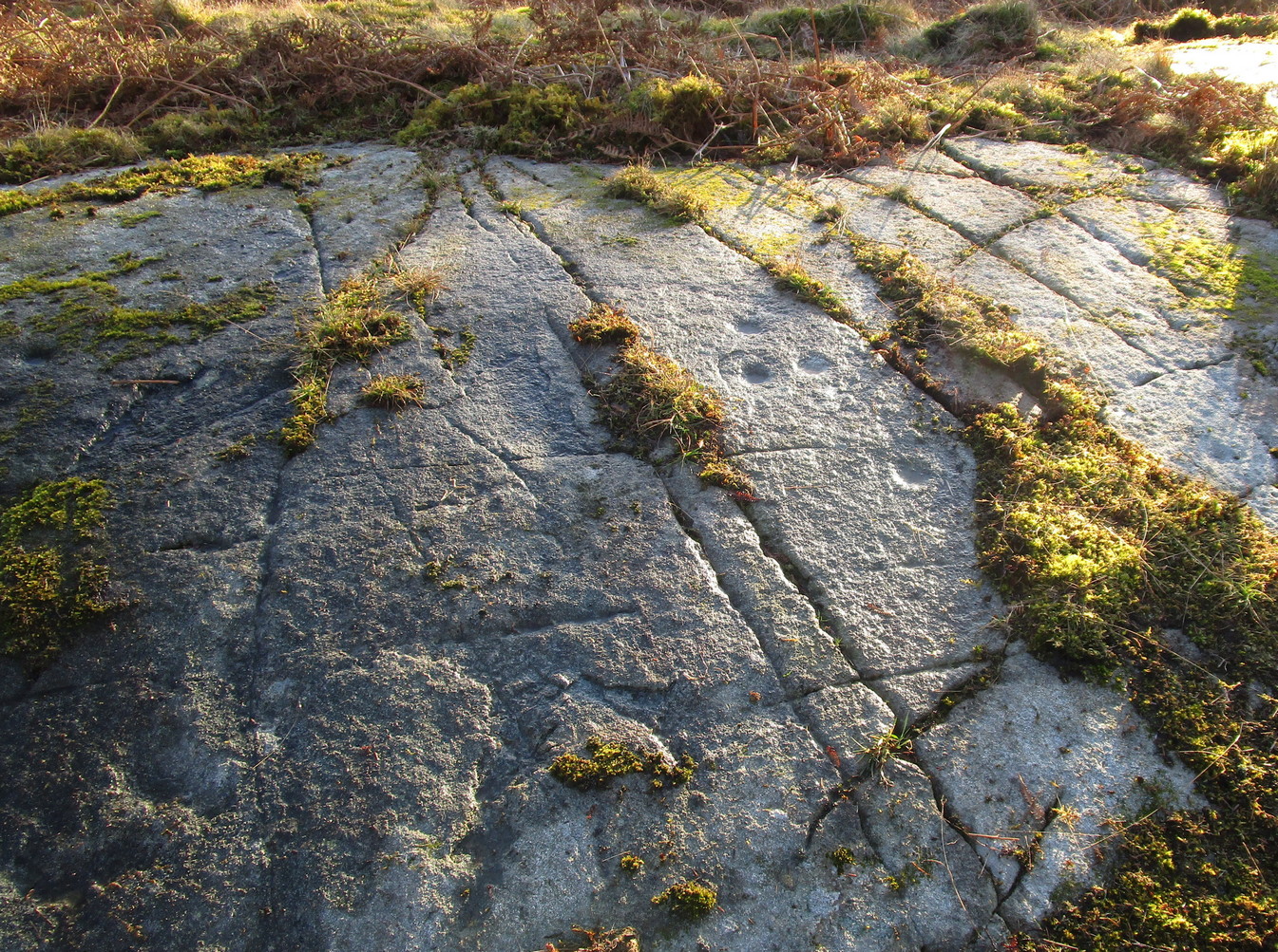
It’s on the sloping south-side of the stone where the best cluster is found.  At least ten faint cup-marks—one or two with very faint incomplete rings round them—are arranged in gentle arcs into the rock.  On both sides of this section is a covering of vegetation, beneath which the carved designs probably continue.  In fact if this entire stone dome was completely free of vegetation, it’s likely we’d have a much larger piece of prehistoric rock art.  A job for future antiquarians perhaps…

References:

  1. Morris, Ronald W.B., “Glentarken Wood, Strathyre – Cup-marked Rocks,” in Discovery & Excavation Scotland, 1969.

Acknowledgments:  Big thanks to Paul Hornby for use of his photographs.  Cheers dood. 😉

© Paul BennettThe Northern Antiquarian

The map could not be loaded. Please contact the site owner.

Castleton (12), Cowie, Stirlingshire

Cup-and-Ring Stone:  OS Grid-Reference – NS 86032 87706

Also Known as:

  1. Castleton 8 (van Hoek)

Archaeology & History

Castleton-12 carving

Located near the top of one of Castleton’s rocky island outcrops and overlooking extensive flatlands many miles to the south, this impressive multi-ringed carving was  rediscovered in May 1985 by the Ordnance Survey lads and, I believe, was first described in an article by Maarten van Hoek (1996), whose description we’ll get to shortly.  It’s a design that incorporates some of Nature’s own cup-marks alongside the marks of men.

The overall design here is captured within three sections of the rock: between three large natural cracks running roughly north-south, as clearly shown in the accompanying photos.  It’s a multi-period carving, executed over what seems to be a considerable period of time—probably several centuries.  I base this on the differing degrees of erosion between the respective multiple rings — a factor found several of the Castleton carvings.

Eastern & central cup ring symbols
Closeup of central rings

One of the most eroded sections can be seen on the eastern side of the rock, where a very faded cup-and-three-rings was carved.  Initially it looked as if there was no central cup to this, but as I looked across this towards the falling sun, what seemed to be a possible ‘dot’ was noticed in the centre, very faint indeed.  There are several single cup-marks just a few inches east of this triple-ring, which look more recent than its eroded companion.

On the other side of the long natural crack we see two quite distinct multiple cup-and-rings: one with three rings and another with four, both of which have short carved lines running from their centres westwards.  Between these, a smaller single cup-and-ring nestles quietly, almost innocuously, minding its own business!  But below these two large multiple-ringers there’s a very faint cup-and-double ring, only visible when the light conditions are just right.  In numerous attempts I made to catch this element in my photos, none were successful. (I’m a crap photographer, which doesn’t help!)  Due to the erosion on this element, this is possibly the earliest section of the carving.  Above these rings, close to the edge of the small cliff, one or two carved lines can be seen that run into natural ‘bowls’ which, in all probability, were of some significance to those who made this design.  In cultures outside the UK, such elements have sometimes been afforded mythic importance.

Several other natural small ‘bowls’ exist above the most blatant of the cup-and-rings here, on the west side of the rock, which consists of a cup-and-triple-ring no less.  Erosion levels on this would seem to suggest that it was the most recent element of this petroglyph.

When Maarten van Hoek (1996) wrote his report, there was much less vegetation covering the stone and another cup-and-ring could be seen on the northernmost section of the rock – as his sketch here shows.  He wrote:

Westernmost element
van Hoek’s 1996 sketch

“Near the edge are five cup-and-rings and possibly up to four single cups, all on rock sloping about 6″ to 12″ NW.  The easternmost set consists of the worn remains of three rings (the innermost hardly visible) without a distinct central cup.  Across a crack is a cup with four rings, the outer incomplete and curving away; another cup with four rings, mostly incomplete.  A small cup-and-one-ring sits in between.  South of this group may be some grooves and a single cup, all doubtful being very near the cliff-edge which is heavily pitted by erosion.  The westernmost cup with three ovalish rings is the best preserved set of the group.  Further away from the scarp is one single cup on a horizontal part and even further N is a cup-and-two-rings on a part sloping 6″ SW.”

It would be good to completely clear this rock and make it all visible again, as it was long long ago…

References:

  1. Morris, Ronald W.B., The Prehistoric Rock Art of Southern Scotland, BAR: Oxford 1981.
  2. van Hoek, M.A.M.,”Prehistoric Rock Art around Castleton Farm, Airth,” in Forth Naturalist & Historian, volume 19, 1996.

© Paul BennettThe Northern Antiquarian

The map could not be loaded. Please contact the site owner.

Castleton (11), Cowie, Stirlingshire

Cup-and-Ring Stone:  OS Grid-Reference – NS 85725 88008

Archaeology & History

Amidst the cluster of at least twenty petroglyphs found at Castleton, this example close to the fence 60 yards southeast of the farmhouse, wasn’t included in the earlier surveys by Morris (1981) and van Hoek. (1996)  At this spot there a large smooth sloping rock broken into separate parts with natural cracks running over it at different angles, partially covered in soil.  The stone faces north.  On the easternmost side there exists a number of carved symbols, most notable of which is a large double cup-and-ring.  You can’t really miss it!  The other elements however, can be a little more troublesome to see…

Cup, rings & cross
Castleton 11 carving

A curious motif is the quite notable ‘cross’ that’s been pecked onto the stone, above the primary cup-and-ring.  This cross is probably a later addition to the petroglyph, perhaps added to christianize the original mythic function.  From the cross, it looks as if a curved line has been carved down towards the double-ring, nearly linking them together, which could also be viewed as a movement from the pre-christian to the new christian meaning conferred upon the stone.  …Just an idea…

It should be noted that a faint cross was also cut into natural cracks in the Castleton 2 carving, 380 yards northwest of here.

There are two more cup-and-rings on the stone, both on the right-hand side of the cross.  These were carved quite separately over large periods of time, as evidenced by their degrees of erosion.  One cup-and-ring (if you can call it that) is a somewhat erratically executed series of peck-marks that strives to join up with each other, almost failing miserably, creating a somewhat disjointed cup-and-ring.  Next to this, but much much fainter, is a cup-and-half-ring that was obviously carved decades, if not centuries earlier.  You can just make them out in the two photos here, to the right of the cross.

Carving in negative

Another very faint cup-and-half-ring also exists to the left of the primary motif that was only visible from one or two angles when we visited the place the other day, but barely shows up on any of the photos we took.  There are a number of single cup-marks, mainly between the double-ring and the smaller cup-and-rings, some of which are probably natural, but several seem to have been  worked upon by human hands.

A now-hidden petroglyph—known as “Castleton-3” in the Morris and van Hoek surveys—consisting of multiple cup-and-rings, exists beneath the mass or gorse bushes about forty years to the southwest.  We could do with cutting this back so we can see the carving again.

References:

  1. Morris, Ronald W.B., The Prehistoric Rock Art of Southern Scotland, BAR: Oxford 1981.
  2. van Hoek, M.A.M.,”Prehistoric Rock Art around Castleton Farm, Airth,” in Forth Naturalist & Historian, volume 19, 1996.

© Paul BennettThe Northern Antiquarian

The map could not be loaded. Please contact the site owner.

Piper’s Crag Stone, Addingham Moorside, West Yorkshire

Cup-and-Ring Stone:  OS Grid Reference – SE 08497 47097

Also Known as:

  1. Carving no.44 (Hedges)
  2. Carving no.212 (Boughey & Vickerman)
  3. Piper’s Stone

Getting Here

Piper Stone (photo by James Elkington)

Follow the directions to reach our superb Swastika Stone from Ilkley, visible due to the iron railing that surround and protect the carving on the cliff edge.  From here, keep walking west along the Millenium Way footpath, over the stile of the first wall, then the second wall—six in all—for ⅔-mile (1km), where you’ll see another small crag of rocks on your right, just yards from the footpath.  You’re damn close!

Archaeology & History

When the great J. Romilly Allen (1882) visited the Ilkley petroglyphs in 1878, the Piper Stone was one that he wandered over to see—and he had this to say of it:

“At the edge of Piper’s Crag is a horizontal rock-surface, and on a portion of it, measuring 5ft by 7ft, are carved a series of fifteen cups varying in diameter from 2 to 3 ins.  Of these, one is surrounded by a single ring, four by a double ring, and one by a triple ring.”

Hedges 1986 sketch
Cowling’s 1940 sketch

This type of description, whilst accurate on the whole, rarely does justice to the carving.  It was echoed more than 100 years later in John Hedges’ (1986) survey, when he described the large rock jutting out to possess merely, “a complicated design of cups, rings and grooves.”  When Boughey & Vickerman (2003) did their follow-up survey, they added nothing more.

In an attempt to give some sort of meaning to the carving (and many others), the late great Eric Cowling (1940; 1946) placed it within Henri Breuil’s (1934) classification system, which assigns all carvings different degrees of complexity and form, from Classes 1-4.  The Piper Stone entered Breuil’s Class 3A, being one “with deeply cut and smoothed down grooves.” Whilst this may sound good on the surface, in truth such classifications are utterly meaningless outside of the tables and graphs of statisticians and the boring.  They give the appearance of quantitative research, but they have as much bearing on the nature of the carvings as an energy dowser healing the place with crystals.

Piper Stone (photo by Josh Millgate)
Close-up of design (photo by James Elkington)

In the flesh, in the real world—so to speak—from the Piper Stone we are looking, not just at the carving, but its place in the landscape: an ingredient that more and more emerging archaeologists are recognizing has a synergistic relationship with some petroglyphs.  And here we have an impressive landscape that reaches out ahead of us for many miles.  We look primarily to the north: the Land of the Dead in many traditional northern cultures.  But our panorama here is 180º, with east and west horizons having the potential for measuring equinoctial periods in the cycle of the year.  But in truth this is sheer speculation.

It’s a worthwhile carving to see, both for its views and its excess of non-linearity.  In its form, Rorscharch impressions of early humans emerge; the usual solar and lunar symbols can be seen; star systems seem apparent; maps or settlement ground-plans could be there.  We know that somewhere within it is the animistic ‘spirit’ of the rock itself, but the forms it exalts are, once again, all but lost on us modern folk…

References:

  1. Allen, J. Romilly, “Notice of Sculptured Rocks near Ilkley,” in Journal of the British Archaeological Association, volume 38, 1882.
  2. Allen, J. Romilly, “Cup and Ring Sculptures on Ilkley Moor,” in The Reliquary and Illustrated Archaeologist, volume 2, 1896.
  3. Anonymous, Walks around Cup and Ring Stones, TIC: Ilkley n.d. (c.1990).
  4. Baildon, W. Paley, “Cup and Ring Carvings: Some Remarks on their Classification and a New Suggestion as to their Origin and Meaning,” in Archaeologia, volume 61, 1909.
  5. Bennett, Paul, “Cup-and-Ring Art”, in Towards 2012, volume 4, 1998.
  6. Bennett, Paul, The Old Stones of Elmet, Capall Bann: Milverton 2001.
  7. Boughey, Keith & Vickerman, E.A., Prehistoric Rock Art of the West Riding, WYAS: Wakefield 2003.
  8. Breuil, Henri, “Presidential Address for 1934,” in Proceedings Prehistoric Society East Anglia, 7:3, 1934.
  9. Collyer, Robert & Turner, J.H., Ilkley: Ancient and Modern, William Walker: Otley 1885.
  10. Cowling, E.T., ‘A Classification of West Yorkshire Cup and Ring Stones,’ in Yorkshire Archaeological Journal 1940.
  11. Cowling, E.T., Rombald’s Way: A Prehistory of Mid-Wharfedale, William Walker: Otley 1946.
  12. Hedges, John (ed.), The Carved Rocks on Rombalds Moor, WYMCC: Wakefield 1986.

Acknowledgements:  Huge thanks to Josh Millgate and James Elkington for use of their photos in this site profile.  Cheers guys. 🙂

© Paul BennettThe Northern Antiquarian

The map could not be loaded. Please contact the site owner.

Castleton (7c), Airth, Stirlingshire

Cup-Marked Stone:  OS Grid Reference – NS  8551 8819

Archaeology & History

Looking down on C-7c

Near the northwestern end of the small geological ridge that runs to the west of Castleton farmhouse, close to an awesome nine-ringed carving, we find this more simplified triple-ringed petroglyph.  And although the carving is easy enough to describe, its labelling (as ‘Castleton 7c’) is rather troublesome.  As with other carvings in this locale, the name of the stone is based on a survey done by Maarten van Hoek in the mid-1990s.  But van Hoek’s sketch of Castleton 7c and the one shown in our photos, whilst very similar, possess attributes that aren’t on van Hoek’s drawing.  Now this isn’t too odd, as many petroglyphs look different when lighting conditions change; to the point where some features you can see one day are almost invisible the next.  But this carving has attributes that are very difficult to miss – and van Hoek’s detailing tended to be good.  But, all this aside: until we can verify with certainty one way or the other and despite my suspicions that this isn’t what van Hoek described, I’m still entering this carving as Castleton 7c. So – now that bit’s out of the way…!

When we visited the site two years ago the day was dark and overcast, so we didn’t really have good conditions for seeing any faint carvings.  But this wasn’t faint, thankfully.  It was completely buried beneath soil and gorse bushes, but thankfully Paul Hornby managed to unearth the one you can see in the photos.  If it is the Castleton 7c petroglyph, it was rediscovered by van Hoek on one of his ventures here in 1985.

Carving showing wavy lines on right
…and from another angle

When we visited the site we only managed to uncover a small section of the stone, as the roots of the surrounding gorse prevented us from seeing more. (it’s tough stuff unless you’ve got the right gardening equipment!)  The section we uncovered consisted of a cup-and-triple-ring.  This is consistent with van Hoek’s sketch and description; but we also found there were two very notable ‘arcs’ on the outer edge of the rings—nearly opposite each other—as if another, fourth ring had been started.  You can’t really miss these elements – and even in the poor lighting conditions we had, these outer arcs are very evident on a number of photos – especially when they are expanded to full-scale.  However, as I mentioned, we were unable to uncover all the rock; but when van Hoek was here there was far less herbage.  What he saw on this carving was as follows:

“Deturfing part of this ridge revealed a fine cup with three rings with a broadly pecked tail; one solo cup; one large oval ring with small central cup; and a faint cup with two rings, the outer one incomplete.  The rock slopes 12º ENE.”

Crap drawing done in crap lighting
van Hoek’s 1996 sketch

The “broadly pecked tail” he mentions is also not really clear in any of the 60 photos we took.  There is a faint line that runs through the three rings, into the central cup and out the other side: a single curving line no less.  It’s certainly visible, but it’s far from broad.  But there are a number of other lines coming out of the rings.  These maybe just natural scratch marks, or even scratches acquired from farming activity.  It’s difficult to say.  In the poor light that we had, there as looked to be a single cupmark a few inches away from the rings, but this isn’t consistent with the position of the cupmark on van Hoek’s sketch.

There’s a simple solution to all this: we need to revisit the site and expose more of the rock.  At least that will tell us once and for all whether this is the same as van Hoek’s stone, or whether we’ve found yet another new carving. Watch this space, as they say! 😉

References:

  1. van Hoek, Martin A.M., “Prehistoric Rock Art around Castleton Farm, Airth, Central Scotland,” in Forth Naturalist & Historian, volume 19, 1996.

© Paul BennettThe Northern Antiquarian

The map could not be loaded. Please contact the site owner.


Allt a’ Choire Chireinich (06), Ben Lawers, Kenmore, Perthshire

Cup-Marked Stone:  OS Grid Reference – NN 65309 39553

Getting Here

Allt a’ Choire Chireinich 6

Follow the directions to reach the faint but impressive Allt a’ Choire Chireinich (04) petroglyph.  Standing here, you’ll notice the large boulder that looks as if it’s fallen down the slope immediately to your left.  You can’t really miss it.

Archaeology & History

Beneath the gorgeous excess of ancient lichens you can make out at least three cup-marks on the south-facing sloping rock-face in the top-half of the boulder.  There may be some other faint cups on here, but due to the lichens they are very difficult to see, so I’m erring on the side of caution regarding their veracity.  This is another one of those carvings likely to be interest only to the most ardent petroglyphic nuts amongst you.

© Paul BennettThe Northern Antiquarian

The map could not be loaded. Please contact the site owner.

Allt a’ Choire Chireinich (05), Ben Lawers, Kenmore, Perthshire

Cup- Marked Stone:  OS Grid Reference – NN 65305 39555

Getting Here

Allt a’ Choire Chireinich 5

Follow the directions to reach the faint but impressive Allt a’ Choire Chireinich (04) petroglyph.  Standing here, look straight down at the dried-up burn barely ten feet below you, where you’ll see a small sloping rock.  That’s it!

Archaeology & History

Nothing much to see here apart from a single shallow cup-marking.  Most likely of interest only to the most ardent petroglyphic explorer.

© Paul BennettThe Northern Antiquarian

The map could not be loaded. Please contact the site owner.

Castleton (5f), Airth, Stirlingshire

Cup-Marked Stone:  OS Grid Reference – NS 85584 88087

Archaeology & History

As with other carvings in this locale, the name of the stone is based on a survey done by Maarten van Hoek. (1996)  It’s a pretty simplistic design within the impressive Castleton complex, found at the southeastern end of the gorse-covered rocky ridge, about 70-80 yards west of the farmhouse.  It was uncovered on a visit here by Nina Harris, Paul Hornby, Frank Mercer and Lisa Samson on Sunday 19 November, 2018.

The cup-marked stone
Large cup & arc of 3

Unlike the others in the Castleton complex, this carving is probably of interest only to the hardcore petroglyph hunters.  The design consists of at least ten cup-marks on the uncovered section of the rock, one of which appears to have a broken circle with two ‘entrances’ either side of it, so to speak.  The most notable element in the design is close to the edge, where an arc of three cups almost corners a larger cup right at the edge.   There may be more carved elements to be found on the westerly side of the stone, which was covered in deep vegetation when we came here.

References:

  1. van Hoek, Martin A.M., “Prehistoric Rock Art around Castleton Farm, Airth, Central Scotland,” in Forth Naturalist & Historian, volume 19, 1996.

© Paul BennettThe Northern Antiquarian

The map could not be loaded. Please contact the site owner.


Pitcur Souterrain (3) – Carving 2, Kettins, Perthshire

Cup-and-Ring Stone:  OS Grid Reference – NO 25290 37378 

Getting Here

MacRitchie’s 1900 groundplan

Follow the same directions as if you’re visiting the Pitcur (3) souterrain.  Once here, you’re standing at the southernmost uncovered section of the monument, where one uncovered passageway bends round and meets up with another open section (“m” on MacRitchie’s plan, right).  From here, just to your right, a single large roofing stone joins one side of the open passageway with the other, enabling you to walk across it—and the stone you’d walk across has these very faint carvings on it.

Archaeology & History

Shortly before darkfall a few weeks ago, Nina Harris, Frank Mercer, Paul Hornby and I were just about ready to pack-up and leave the brilliant Pitcur souterrain with its underground chambers and various petroglyphs when, as I walked along one of the open passages beneath one of the monument’s many large capstones, my fingers gently stroked the rock above me, almost unconsciously.

First photo of the carving (by Paul Hornby)

“Was that a faint cup-mark?” I asked myself, fondling gently the smooth stone once more.

Standing eight-feet above me in the long grasses, Mr Hornby was gazing around in his usual way.

“Paul – can you see from up there if this is a cup-marking I’m feeling here?”

Walking onto the edge of the rock itself, he proclaimed, “it looks like it!”

It was indeed!  And during the remaining 30 minutes of daylight we found that the single cup-mark had a number of companions on the same stone.  With multiple rings!  Twas another good day out.

Carving when wet (photo, Frank Mercer)

Looking straight down

Previously unrecorded, this large rounded stone just about covers the space across from one side of the souterrain passage to the other, measuring roughly 6 feet by 4 feet, with its longer axis positioned roughly east-west.  It was on the westernmost edge of the stone where I located the first single cup-mark, close to the edge, but there are perhaps 12  others: three of which, as the photos show, are in a straight line from near the west-side of the stone to the upper-middle.  On its far eastern edge, another cup-mark is clearly evident; whilst on its southernmost edge is another.  It’s the middle and eastern section of the rock that grabs most of the attention.  Here we found the very faint rings becoming clearer and clearer as the dust of ages was carefully swept away, eventually giving us vision of carvings that were, in all likelihood, first pecked into the rock in the neolithic period, 4-6000 years ago.

Close-up of the 2 triple-rings

Cup-and-rings at an angle

As we can see, two faint triple-rings exist, each with lines running in/out of them.  The eastern concentric system is just about complete and has a small cup-mark on the NW edge of the outer ring.  A line that runs out from the central cup meets another carved line which, from some angles, appears to look almost like a bowl beneath the triple rings—but this is unclear.  The other triple cup-and-ring, slightly closer to the middle of the stone, has an incomplete outer ring, with evidence of another line running outwards from its central cup. There seems to be a slightly-pecked outline of a single cup-and-ring on the north side of the stone, but this is also unclear.

In truth we need to revisit the site soon, when the lighting gives us a clear idea of what we actually found, because our visit here was cut short by encroaching night and a grey cloudy evening—which are not the best conditions for isolating new petroglyphs!

At least six other petroglyphs exist within the Pitcur Souterrain (3), with the one closest to this (Pitcur 3:3) also used as a roofing stone, covering the deep trench from one side to the other.  However, it would appear the petroglyphs on that stone were on its underside, as the erosion on it is negligible, away from the elements—unlike this one! Another capstone that was also turned over (Pitcur 3:4) was found to possess more cup-and-rings, again on the underside of the stone.

This carving was probably executed 2-3000 years before the souterrain came into existence, and as a result of this we’re unsure as to the original location of the stone—but it was probably close by.  It might have originally been a carved standing stone, re-used here; or been part of a lost prehistoric tomb; or even a loose earthfast rock (though this is the least likely of the three).  Why it was used, and whether it retained any sense of the original meaning when it was re-positioned into the present construction, is a relevant question.  In all likelihood some of the original mythic element—or a morphed development of its original animistic narrative–was probably a functional ingredient of importance to the souterrain builders, 2-3000 years after the carving had been made.

A superb site!

References:

  1. Wainwright, F T., The Souterrains of Southern Pictland, RKP: London 1963.

Acknowledgements:  This site profile would not have been made possible were it not for the huge help of Nina Harris, Frank Mercer & Paul Hornby.  Huge thanks to you all, both for the excursion and use of your photos in this site profile. 🙂

© Paul BennettThe Northern Antiquarian

The map could not be loaded. Please contact the site owner.


Kalemouth Carving, Eckford, Roxburghshire

Cup-and-Ring Stone:  OS Grid Reference – NT 714 275

Archaeology & History

Kalemouth carving (after R.W.B. Morris 1981)

Now housed in the National Museum of Antiquities in Edinburgh, this little-known petroglyph was rediscovered in 1957 by a Mr G.F. Ritchie, not far from the once-large Kalemouth neolithic tomb.  It’s a carving that seems to be quite isolated (no others are known about in the immediate area), comprising of an incomplete four-ringed design which, in all probability, is a stray rock that came out of a nearby prehistoric cairn—although we don’t know this for sure.

The carving was described in Ron Morris’ (1981) petroglyph survey, where he told us that,

“In the field “not far from the cairn” (just E of the farm), was a small convex gritstone boulder 25cm by 15cm by 15cm (¾ft  x ½ft x ½ft). On its fairly smooth surface is:

a cup-and-four-rings with 2 parallel grooves from the inner ring (which is incomplete) through the others (which are gapped)—the outer two being now incomplete also—a form of ‘keyhole pattern’.”

A near-identical carving on a similiar-shaped portable stone can be seen in Galashiels museum, whose history has seemingly been forgotten.

References:

  1. Morris, Ronald W.B., “The cup-and-ring marks and similar sculptures of Scotland: a survey of the southern Counties – part 2,” in Proceedings of the Society of Antiquaries, Scotland, volume 100, 1967.
  2. Morris, Ronald W.B., “The Cup-and-Ring and Similar Early Sculptures of Scotland; Part 2 – The Rest of Scotland except Kintyre,” in Transactions of the Ancient Monuments Society, volume 16, 1969.
  3. Morris, Ronald W.B., The Prehistoric Rock Art of Southern Scotland, BAR: Oxford 1981.

© Paul BennettThe Northern Antiquarian

The map could not be loaded. Please contact the site owner.