Stone of Stars, Rivock, Silsden, West Yorkshire

Cup-and-Ring Stone:  OS Grid Reference – SE 07507 44564

Also Known as:

  1. Carving no.26 (Hedges)
  2. Carving no.65 (Boughey & Vickerman)

Getting Here

A Stone of Stars, Rivock

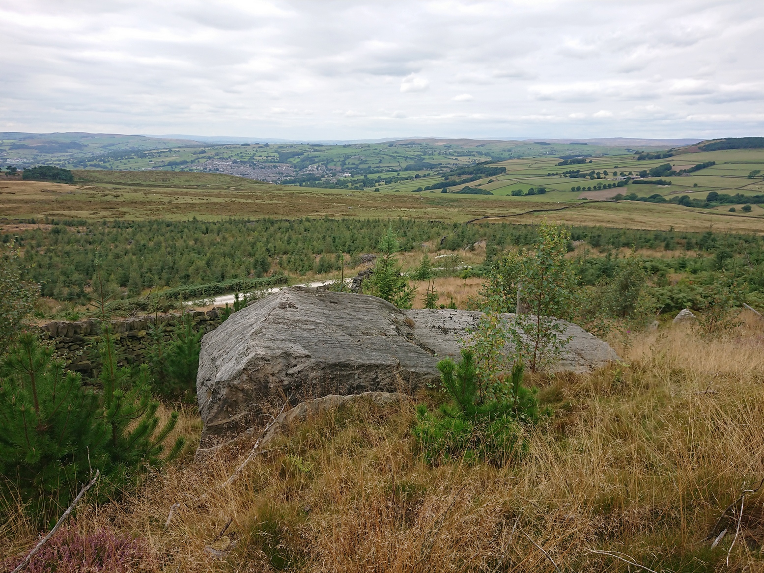
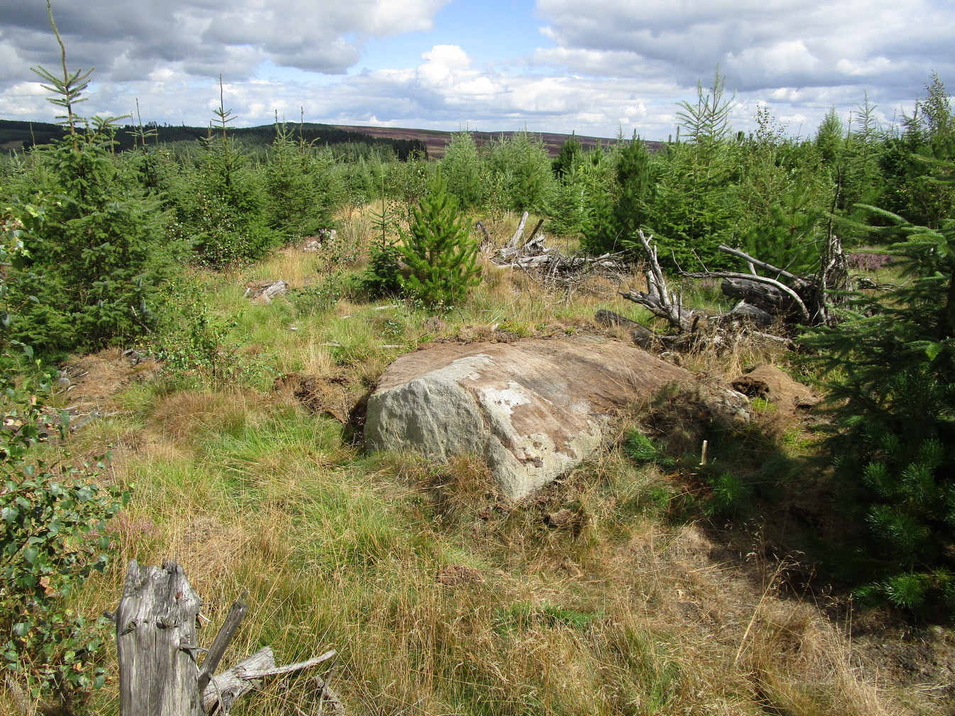
The best/easiest way to approach this and the Rivock carvings as a whole is to reach the Silsden Road that curves round the southern edge of Rombalds Moor (whether it’s via East Morton, Riddlesden, Keighley or Silsden) and keep your eyes peeled for the singular large windmill.  About 200 yards east of this is a small parking spot, big enough for a half-dozen vehicles.  From here walk 450 yards east along the road till you hit the dirt-track/footpath up towards the moor.  Follow the track up for about 400 yards and you’ll see the crags a half-mile ahead of you.  Get up there to the Wondjina Stone and follow the walling east for about 175 yards where you’ll see a track-cum-clearing in the woods. Walk along and the first large stone on your left is what you’re after.

Archaeology & History

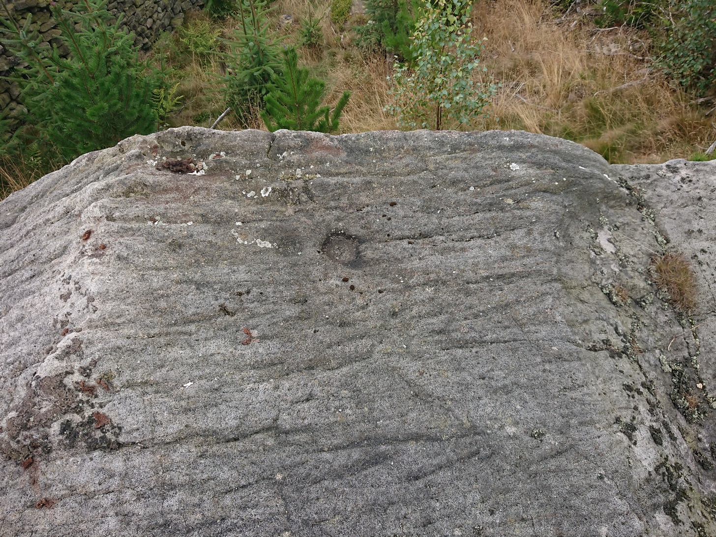
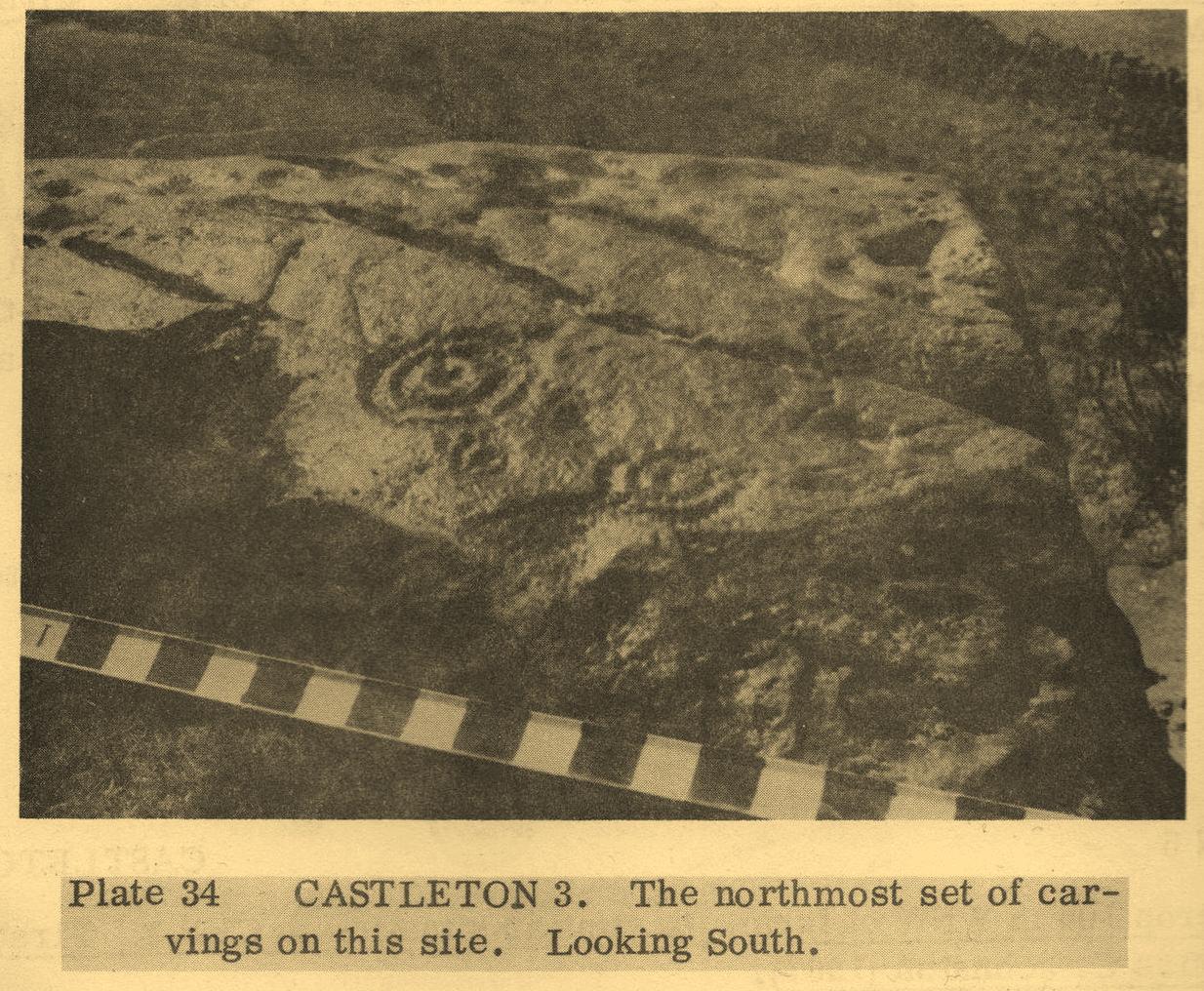
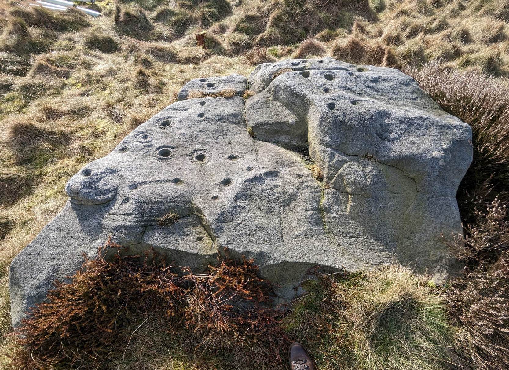
I first visited this carving in my teenage years in the 1970s, before the intrusive so-called “private” forest covered this landscape and when its petroglyphic compatriots were easier to find.  Thankfully this one’s still pretty accessible and possesses a damn good clear design.  It was rediscovered in the 1960s by Stuart Feather and his gang, zigzagging their way across the open moors, pulling back the heather to see what they might find.  His description of it told how the stone,

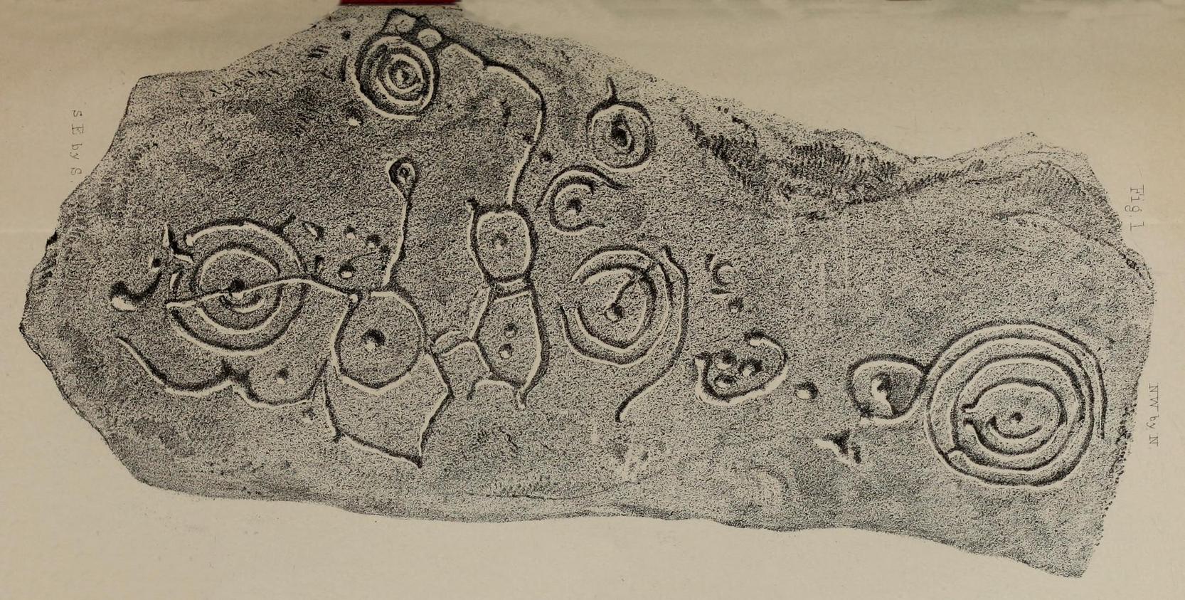
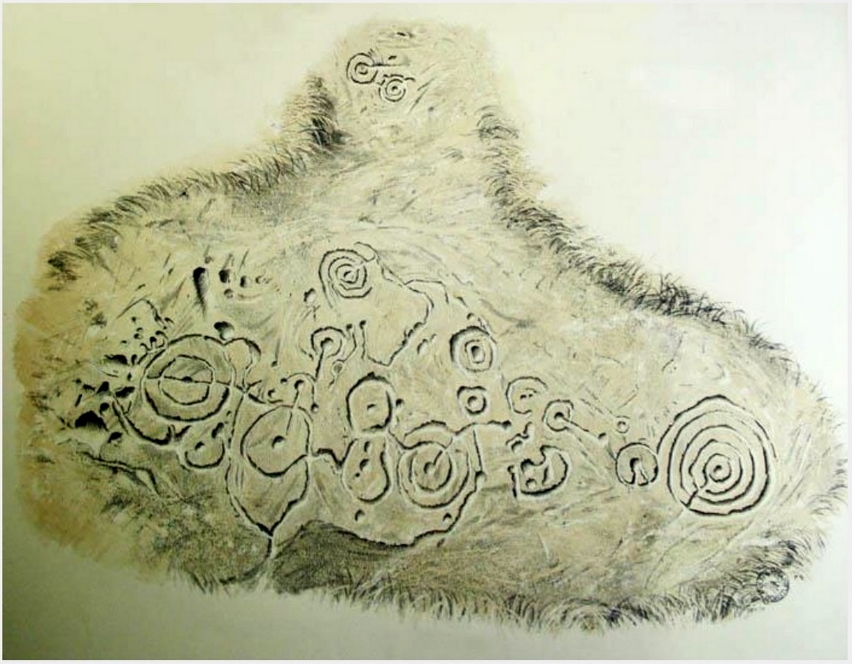
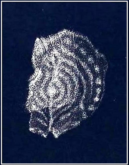
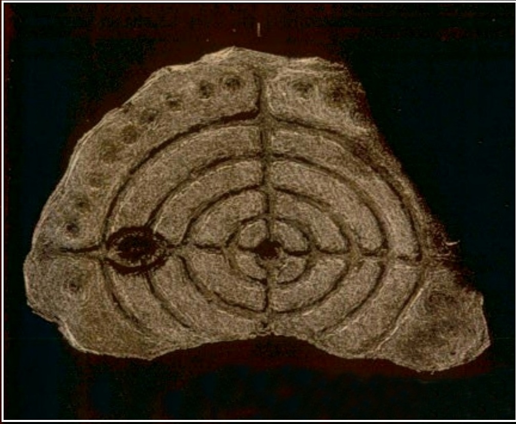
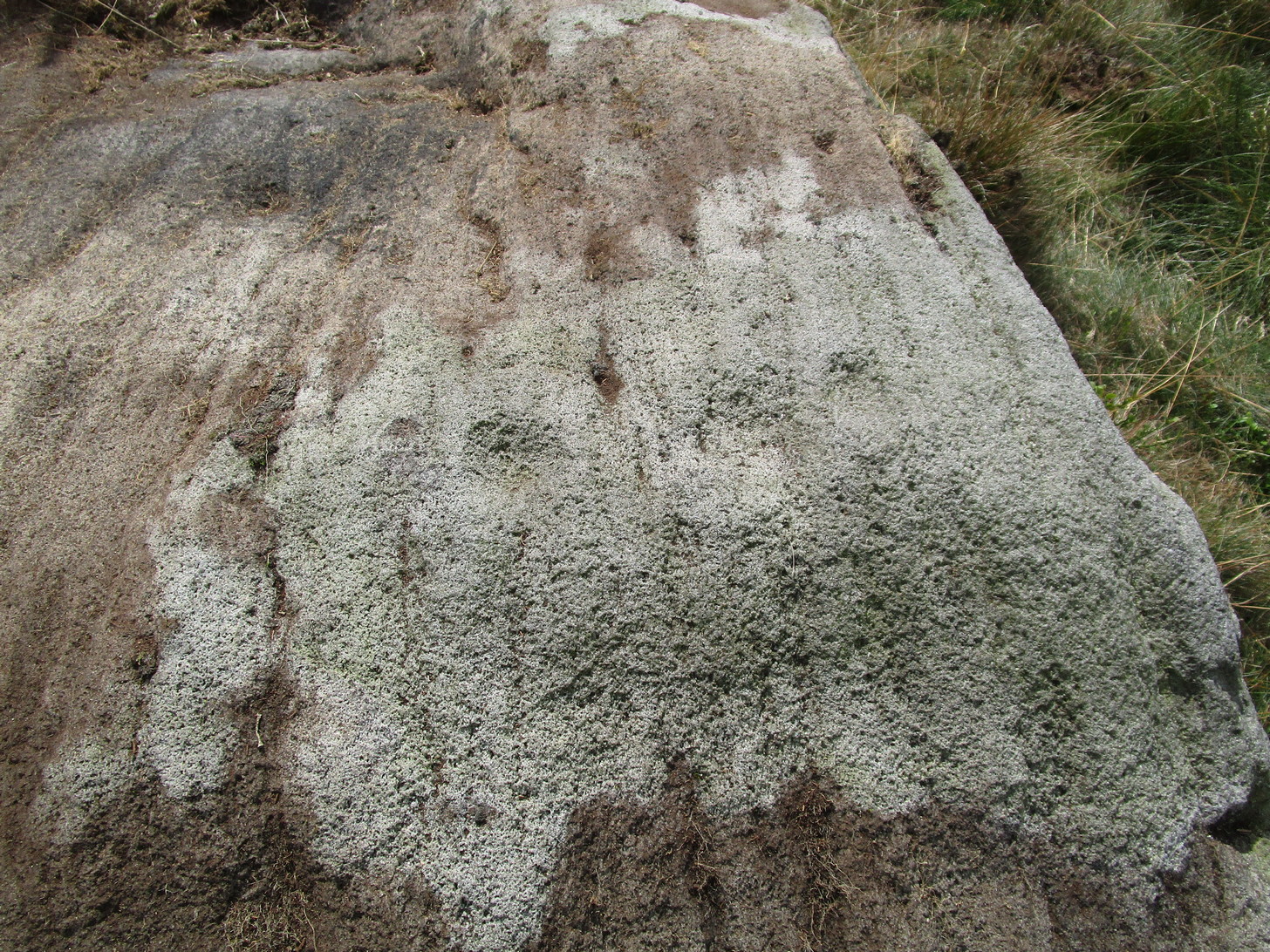
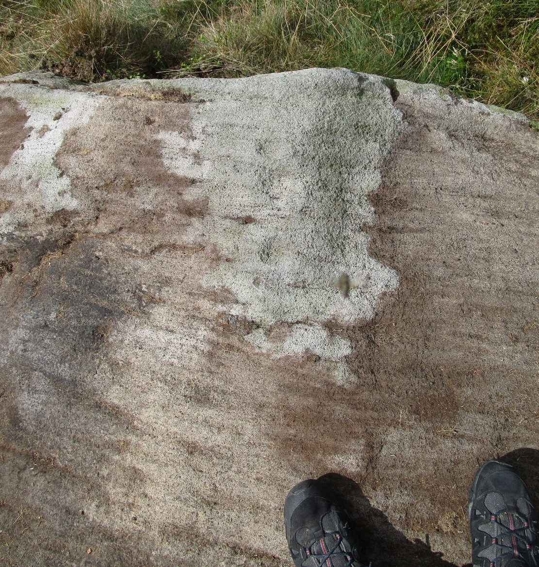
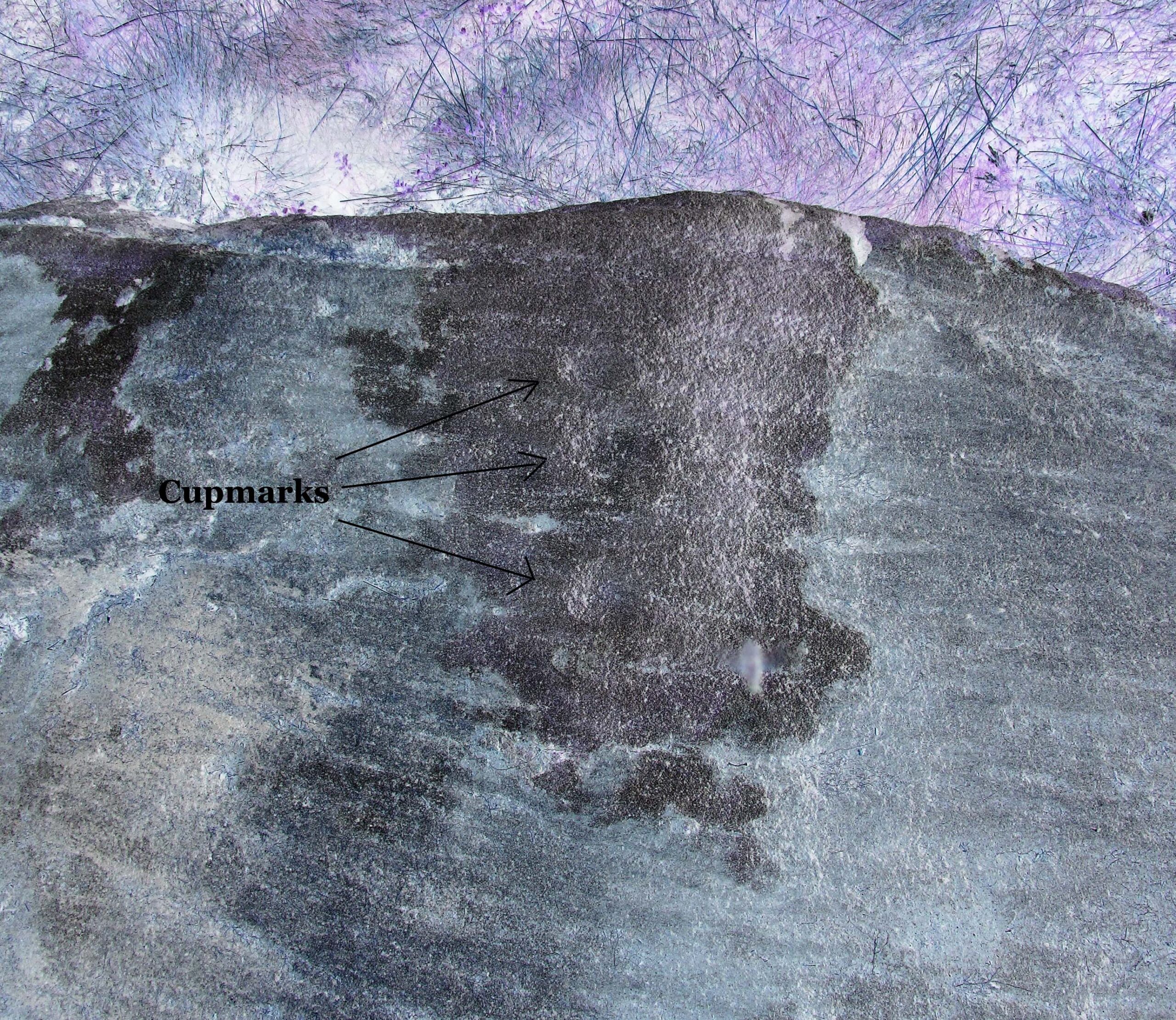
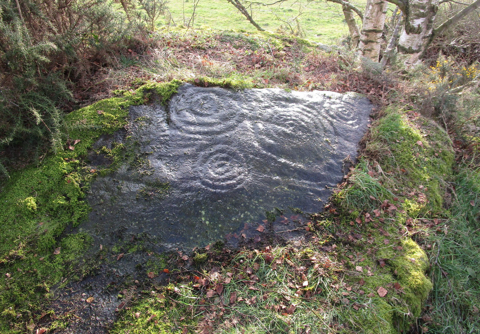
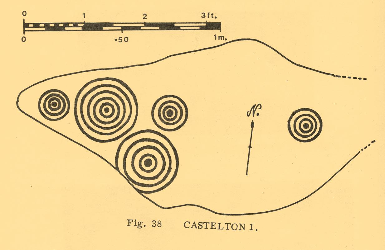
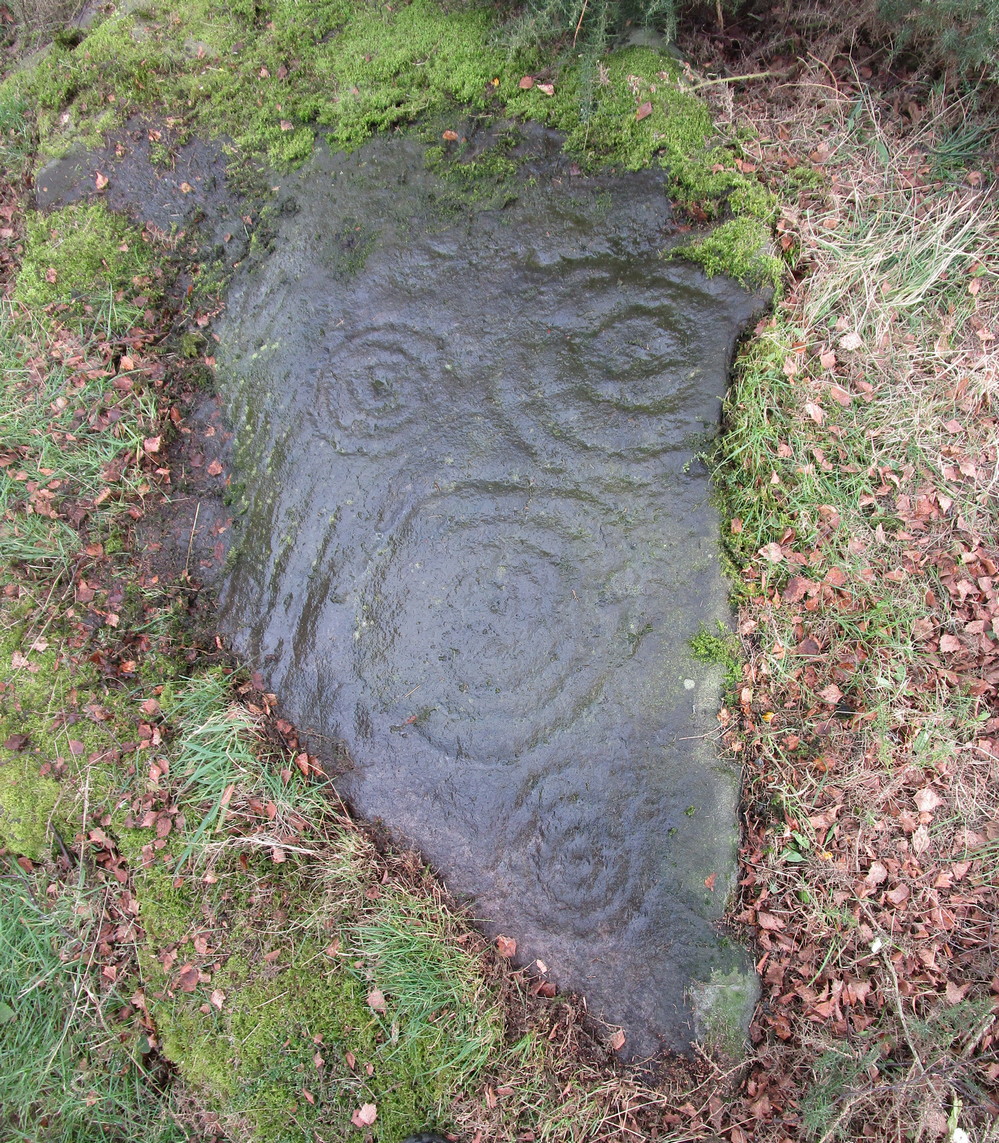
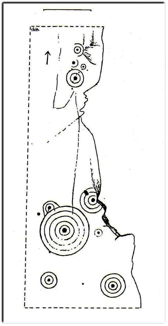
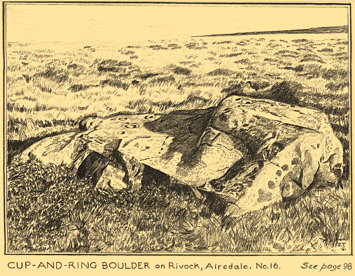
“has two roughly level areas, one 18ins and the other 2 feet above ground level.  Both (levels) have several well-preserved cup-and-ring markings on them.  There are eight single cup-and-rings and 18 cups, two of the latter being joined by a clear channel seven inches long and 1½ inches wide.  Nearly all the markings are unusually well preserved and the pocking marks are very clear.”

Note the line running down

He also had “the impression that all the markings on this stone and possibly one other similar stone in the Rivock area have been carved by the same hand, as all the symbols are nearly identical in in type, size and execution.” (this other carving he’s referring to seems to be one about 170 yards to the north, where occasionally “offerings” have been found)

The design from E-W

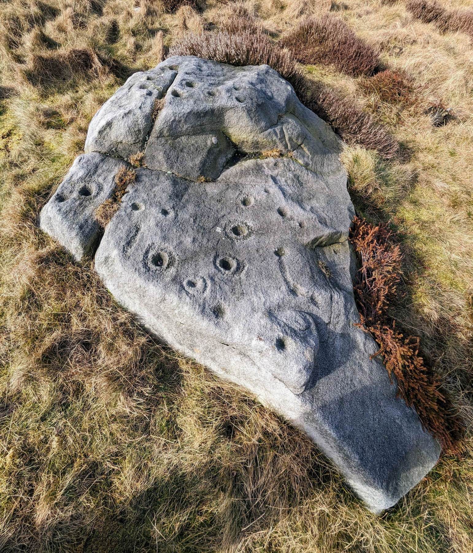
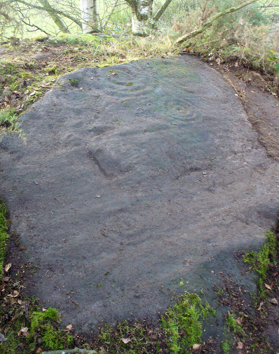
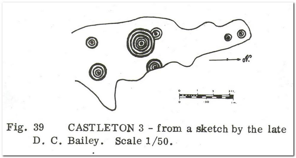
When John Hedges (1986) and his team checked the stone out he could only make out “seven cups with single rings, twenty two other cups”; whilst the ever descriptive Boughey & Vickerman (2003) saw “twenty-nine cups, eight with single rings.”  Eight cup-and-rings is what most people see when the light’s right.  There’s also a long, bent carved line on the lower level of the rock, running from near the middle of the stone out to the very edge.  It seems to be man-made (although I may be wrong) – and I draw attention to it as this same feature exists on at least three of the other large and very ornamental cup-and-rings hereby within 300 yards of each other – and on these other carvings the long “line” is definitely artificial.  Tis an intriguing characteristic…

Stuart Feather’s old sketch

When visiting this petroglyph you’ll notice how some of the carved elements on top of the stone are more eroded than those on the lower section.  This is due to the fact that the lower section was only revealed by Feather and his team in the mid-20th century, after it had been covered in soil for countless centuries.  As a result you can still see the peck-marks left by the implements that were used to make the carving, perhaps 5000 years ago!

The name of the stone was inspired by a local lady who saw an astronomical function in the design (I quite like it as well).  Examples of petroglyphs representing myths of heavenly bodies have been described first-hand in some tribal cultures and, nowadays, even a number of archaeologists are making allusions about potential celestial features in some carvings in the British Isles.  That doesn’t mean to say that it’s correct, but the idea’s far from unreasonable…

Anyhow – check this one out when you’re next up here.  You’ll like it!

References:

  1. Bennett, Paul, “The Prehistoric Rock Art and Megalithic Remains of Rivock & District (parts 1 & 2),” in Earth, 3-4, 1986.
  2. Boughey, Keith & Vickerman, E.A., Prehistoric Rock Art of the West Riding, WYAS 2003.
  3. Deacon, Vivien, The Rock Art Landscapes of Rombalds Moor, West Yorkshire, ArchaeoPress: Oxford 2020.
  4. Feather, Stuart, “Mid-Wharfedale Cup-and-Ring Markings – no.16 – Rivock,” in Cartwright Hall Archaeology Group Bulletin, volume 8, no.10, 1963.
  5. Hedges, John (ed.), The Carved Rocks on Rombalds Moor, WYMCC: Wakefield 1986.
  6. Morris, Ronald W.B., “The Prehistoric Rock Art of Great Britain: A Survey of All Sites Bearing Motifs more Complex than Simple Cup-marks,” in Proceedings of the Prehistoric Society, volume 55, 1989.

AcknowledgmentsHuge thanks to Collette Walsh for use of her photos.

© Paul BennettThe Northern Antiquarian

The map could not be loaded. Please contact the site owner.

Broomridge (1), Ford, Northumberland

Cup-and-Ring Stone:  OS Grid Reference – NT 97298 37110

Archaeology & History

In 1863, a bunch of reputable Victorian authors and antiquarians met with the Duke of Northumberland in Alnwick Castle to discuss the matter of making decent images of the petroglyphs which, at the time, had only just been rediscovered in the area.  At one of their meetings, the floor in one of the Castle rooms was covered with rubbings of carvings that they’d made—this one included.  I’d loved to have been there!  Subsequently, from this meeting, sketches of this carving were done and included in the works by George Tate (1864; 1865) and then a few years later in J. Collingwood Bruce’s (1869) rare tome that had been published with the help of dosh from the Duke.

Found along a raised geological ridge running roughly east-west, a number of other carvings are close by and well worth looking at when you visit here.  The basic (and first) description of the site by Tate told that here,

Tate’s 1864 sketch
J.C. Bruce’s 1869 image

“on a high ridge on Hunter’s Moor, a large surface of rock, some forty yards by twenty, having a gentle slope to the northward, is partially uncovered.  In one part, which has been entirely cleared of turf, fourteen figures are scattered over an area of 15 feet by about from 5 to 7 feet.  Some of the figures are of the common type, one of which is 28 inches in diameter; but others present new features; and several are curiously united by straight and curved grooves.  Across the entire diameter of a group of four concentric circles, runs a groove connecting them with other combined figures.  An irregularly shaped, rounded, angular figure, encloses two hollows or cups; and united to this is a broad oval figure.  One figure around four cups approaches to the reniform.”

When the modern rock art expert Stan Beckensall wrote about this site, he mentioned how his own picture of the carving consisted of a number of elements that weren’t included by the 19th century pioneers—which isn’t unusual.

References:

  1. Beckensall, Stan, Northumberland’s Prehistoric Rock Carvings – A Mystery Explained, Pendulum: Rothbury 1983.
  2. Beckensall, Stan, Prehistoric Rock Motifs of Northumberland – volume 1, Abbey Press: Hexham 1991.
  3. Bruce, John Collingwood, Incised Markings on Stone; found in the County of Northumberland, Argylshire, and other Places, privately printed: London 1869.
  4. Tate, George, “The Ancient British Sculptured Rocks of Northumberland and the Eastern Borders,” in Proceedings of the Berwickshire Naturalists Club, volume 5, 1864.
  5. Tate, George, The Ancient British Sculptured Rocks of Northumberland and the Eastern Borders, Henry Hunter Blair 1865.

© Paul BennettThe Northern Antiquarian

The map could not be loaded. Please contact the site owner.

Jedburgh Abbey, Roxburghshire

Cup-and-Ring Stone:  OS Grid Reference – NT 6504 2045

Archaeology & History

A little-known cup-and-ring stone that was uncovered in the forecourt of Jedburgh Abbey by Walter Laidlow in 1903, now lies all but forgotten in the abbey grounds.  Laidlow’s original description of his find was very basic indeed: “a sculptured stone, with incised ring-and cup-symbols… of yellow sandstone, 1 foot 8 inches long, 9½ inches broad, 4 inches thick.”  The Royal Commission (1956) lads did slightly better, saying:

“A slab of stone… measures 1ft 8½in by 9½in by 4in, and bears on one face six cup-marks ranging from 1in to 2½in in diameter.  The largest of these is encircled by a ring 5in in diameter, in “pocked” technique; while slight traces of what may have been a similar ring can be seen around another cup, which is fractured.”

Laidlow’s 1903 photo

You can see from the photograph how the stone has been broken from a larger piece, strongly suggestive of a greater prehistoric design on the original slab—but there have been no subsequent finds that might show us its original form.  In all likelihood, the stone originally came from a prehistoric tomb, but we know not where that might have been—much like the Mathewson’s Garden carving, also in Jedburgh.

The carving apparently still lies somewhere in the Abbey grounds, sleeping, but I’ve not visited the olde stone so I don’t know its exact position.  If any local folk can tell us more, that would be great!

References:

  1. Laidlaw, Walter, “Sculptured and Inscribed Stones in Jedburgh and Vicinity,” in Proceedings Society Antiquaries, Scotland, volume 39, 1905.
  2. Morris, Ronald W.B., “The Cup-and-Ring Marks and Similar Sculptures of South-West Scotland,” in Transactions of the Ancient Monuments Society, volume 14, 1967.
  3. Morris, Ronald W.B., “The cup-and-ring marks and similar sculptures of Scotland: a survey of the southern Counties – part 2,” in Proceedings of the Society of Antiquaries, Scotland, volume 100, 1969.
  4. Morris, Ronald W.B., The Prehistoric Rock Art of Southern Scotland, BAR: Oxford 1981.
  5. Royal Commission on the Ancient & Historical Monuments of Scotland, Roxburghshire – volume 1, HMSO: Edinburgh 1956.

© Paul BennettThe Northern Antiquarian

The map could not be loaded. Please contact the site owner.

Mathewson’s Garden, Jedburgh, Roxburghshire

Cup-and-Ring Stone:  OS Grid Reference – c. NT 65 20

Archaeology & History

Apart from the petroglyph found at Jedburgh Abbey in 1903, there’s a distinct lack of known cup-and-ring stones in this area; so when the petroglyph pioneer George Tate was in town in 1860, he was fortunate to find a small “portable” stone with a rather impressive design on it.  We don’t (yet) know the exact position of where the stone was located, as Tate simply told how,

“Lying among a heap of stones in Mr. Adam Mathewson’s garden, I detected, on a much weather-worn block, defaced sculpturing of the same family character as those in Northumberland.  …There are five concentric circles, central cup, radial grooves, and a string of cups around the outer circle.  Forty years ago this stone was built into the wall of a house; but whence it originally came is not known.  Doubtless it belongs to the district, and probably had been connected with an interment.”

His final remark would seem most likely and has subsequently been echoed by several other rock art students.  A few years after Tate’s initial find, the carving was mentioned in Sir James Simpson’s (1867) classic work, who told us:

Dr Falla’s 1866 sketch

“Sometime ago Mr Tate, of Alnwick, discovered in the garden of Mr Matthewson at Jedburgh a stone cut with concentric circles, possibly a sepulchral cist, but peculiar in some respects.  The stone is roundish, but broken off at one side, and about eighteen inches broad.  Its face is covered by five incised concentric rings, and through the central cup pass at right angles two straight lines, which completely bisect all the circles.  The outermost circle is about fourteen inches in diameter.  Some inches to the left of the central cup is a second, with one incised circle around it.  Arranged circularly outside of the outermost circle is a series or ring of points or stars, each cut out—so Dr Falla writes me—”as with a single stroke of a pick, rather than hewn out.” I am indebted to the same gentleman for the sketch of this stone.”

Subsequently all other written accounts repeat the same basic description—and each account remained (as we still are) perplexed as to its original location, wondering where on Earth the Rev Adam Mathewson’s garden was in Jedburgh (surely someone must be able to find out?!).  Thankfully the carving itself has been saved and presently lives in the Kelvingrove Art Gallery and Museum, Glasgow.  Whether it ever had any relationship with the petroglyph at Jedburgh Abbey, we don’t yet know.

References:

  1. Laidlaw, Walter, “Sculptured and Inscribed Stones in Jedburgh and Vicinity,” in Proceedings Society Antiquaries, Scotland, volume 39, 1895.
  2. Morris, Ronald W.B., “The Cup-and-Ring Marks and Similar Sculptures of South-West Scotland,” in Transactions of the Ancient Monuments Society, volume 14, 1967.
  3. Morris, Ronald W.B., “The Cup-and-Ring and Similar Early Sculptures of Scotland; Part 2 – The Rest of Scotland except Kintyre,” in Transactions of the Ancient Monuments Society, volume 16, 1969.
  4. Morris, Ronald W.B., “The cup-and-ring marks and similar sculptures of Scotland: a survey of the southern Counties – part 2,” in Proceedings of the Society of Antiquaries, Scotland, volume 100, 1969.
  5. Morris, Ronald W.B., The Prehistoric Rock Art of Southern Scotland, BAR: Oxford 1981.
  6. Royal Commission on the Ancient & Historical Monuments of Scotland, Roxburghshire – volume 1, HMSO: Edinburgh 1956.
  7. Simpson, J.Y., “On Ancient Sculpturings of Cups and Concentric Rings,” in Proceedings of the Society of Antiquaries, Scotland, volume 6, 1866.
  8. Simpson, James, Archaic Sculpturings of Cups, Circles, etc., Upon Stones and Rocks in Scotland, England and other Countries, Edmonston & Douglas: Edinburgh 1867.
  9. Tate, George, “The Ancient British Sculptured Rocks of Northumberland and the Eastern Borders,” in Transactions of the Berwickshire Naturalists Club, volume 5, 1864.

© Paul BennettThe Northern Antiquarian

The map could not be loaded. Please contact the site owner.

Table Rock, Rivock, Silsden, West Yorkshire

Cup-Marked Stone:  OS Grid reference – SE 07326 44696

Also Known as:

  1. Carving no.43 (Boughey & Vickerman)

Getting Here

Table Rock cupmarked stone

If you’re coming via the Keighley-Bingley (Airedale) road, go up to Riddlesden and then up the winding Banks Lane until it meets the edge of the moors.  At the T-junction, turn left and about 330 yards along on your right there’s a dirt-track.  Walk up here, sticking to the track (not the footpath) towards the cliffs of Rivock ahead of you, going through the gate and into the Rivock woods area.  About 450 yards on from the gate on your right-hand side you’ll see the long straight length of walling that runs uphill—and about 60 yards up here, on the left-hand side of the wall you’ll see a very large boulder.  Y’ can’t really miss it!

Archaeology & History

2 of the several cups here

This large natural block, embedded into the hillside about 80 yards below the Wondjina Stone and its companions, is nothing much in the petroglyphic visual scale of things, but is worth checking out for a break if you’re checking out the other good designs in the Rivock cluster.  Upon its sloping flat two-tiered surface there are just a small number of randomly spaced cup-marks of varying sizes: six at least, but perhaps as many as nine altogether.  In times gone by (many years ago) we thought one of them might have had a very faint ring around it, but on my last couple of visits here I couldn’t see anything.

References:

  1. Boughey, Keith & Vickerman, E.A., Prehistoric Rock Art of the West Riding, WYAS: Wakefield 2003.
  2. Hedges, John (ed.), The Carved Rocks on Rombalds Moor, WYMCC: Wakefield 1986.

© Paul BennettThe Northern Antiquarian


The map could not be loaded. Please contact the site owner.

Rivock Top, Silsden, West Yorkshire

Cup-Marked Stone:  OS Grid Reference – SE 0745 4470

Getting Here

Rivock Top stone

Best approached via the Wondjina Stone, then over the wall and follow the geological ridge that bends into the trees.  It’s difficult to find amidst the dense forest and is another one of those carvings that’s probably only for the purists amongst you.

Archaeology & History

If you’re doing the Rivock rock art tour, you might as well give this a go once you’ve checked ou the decent ones nearby.   Here, on a rather large stone we find, on its uppermost ridge, three faint cup-marks next to each other in a very slight curve.  The cup-mark in the middle is slightly larger than its two compatriots and might be natural.  If you were to wet the rock when the sunlight is just right, you’ll probably get a better idea of its real appearance—otherwise we’ll have to let the computer-gadget lads suss it out!

© Paul BennettThe Northern Antiquarian

The map could not be loaded. Please contact the site owner.

Cross Well, Dundee, Angus

Healing Well (destroyed):  OS Grid Reference – NO 4032 3025

Archaeology & History

This old water supply had no direct ‘holy’ nature, despite its proximity to the cathedral, the old market cross and St Clement’s Well some fifty yards away!  Most odd.  A much more mundane story lies behind this long lost water source.  The Dundee historian William Kidd (1901) told us,

“When the public wells were erected, about the year 1749, to supply the town with water from the Lady-well reservoir at foot of Hilltown, one was placed on the High Street, on the east side of the Cross, and was called the Cross Well.”

It didn’t have too long a life either—much like the old Market Cross, for,

“In the year 1777 that quaint structure was demolished.  The platform and octagonal tower were carted away as rubbish, the least decayed stones being selected to be used in other buildings.  The stone shaft, also, was preserved, and placed beside the Old Steeple. With the demolition of the Cross, the Cross Well was cleared away from the High Street, but, as water was an essential to the people, the well was re-erected behind the Town House in St. Clement’s Lane.  In that situation it remained for nearly one hundred years, when, being rendered unnecessary by the introduction of the Lintrathen water supply, it was also demolished, along with the old buildings in the Vault and St. Clement’s Lane, to make room for the additions to the Town House.”

References:

  1. Colville, A., Dundee Delineated, A. Colville: Dundee 1822.
  2. Kidd, William, Dundee Market Crosses and Tolbooths, W. Kidd: Dundee 1901.

© Paul BennettThe Northern Antiquarian

The map could not be loaded. Please contact the site owner.

Glenballoch, Blairgowrie, Perthshire

Cup-Marked Stone (lost):  OS Grid Reference – NO 186 480

Archaeology & History

When J. Romilly Allen (1881) wrote about the megaliths and petroglyphs of Glenballoch, the owner of the property—a Mr George Harris—informed him of other archaeological finds in the locale: one of which was a cup-marked stone with distinct linear elements, whose description reminded me, slightly, of Ilkley’s Idol Stone.  It was found a short distance east of the Glenballoch (or Craighall Mill) stone circle.  Allen told how,

“Mr Harris…informed me that about twenty years ago he had dug up a stone with cup-markings upon it, on the opposite side of the valley to the south-east of the Glenballoch stone.  The stone lay horizontally with the cups uppermost.  It was split up and is now built into the out buildings of Glenballoch Farm.  The two largest fragments form the cover and sill of the hole through which the shaft of the threshing machine passes through the wall of the horse-mill, into the house.  A third fragment is built in above the window at the opposite side of the house, and is of greenish hue. Mr Harris expressed his great regret at not having known the value of this stone when he broke it up, and he is evidently proud of the stone which remains, and is determined that no ill shall befall it as long as he remains its guardian.  The cup marks on the stone which was broken appear to have been arranged symmetrically in two rows, and Mr Harris affirms distinctly that they were alternately circular and rectangular.”

These three stone fragments have not been seen since.  They may still be covered over in the spot Mr Harris described, but no one seems to have found them.  In the event that someone manages to find them, see if you can get a few good photos and stick ’em on our Facebook group.

References:

  1. Allen, J. Romilly, “Notice of Three Cup-Marked Stones, and the Discovery of an Urn, in Perthshire,” in Proceedings of the Society of Antiquaries Scotland, volume 15, 1881.
  2. Royal Commission on the Ancient & Historical Monuments of Scotland, North-East Perth: An Archaeological Landscape, HMSO: Edinburgh 1990.

© Paul BennettThe Northern Antiquarian

The map could not be loaded. Please contact the site owner.

Castleton (10), Cowie, Stirlingshire

Cup-and-Ring Stone:  OS Grid-Reference – NS 85887 88394

Also Known as:

  1. Castleton 1 (Morris 1891)
  2. Castleton 1a (van Hoek)
  3. Gosham Park

Getting Here

Castleton-10, looking S

To reach here from Stirling or Bannockburn, take the B9124 east to Cowie (and past it) for 3¾ miles (6km), turning left at the small crossroads; or if you’re coming from Airth, the same B9124 road west for just about 3 miles, turning right at the same minor crossroads up the long straight road.  Drive to the dead-end of the road and park up.  You’ll notice that this is a crossroads of dirt-tracks.  Walk along the one that heads to the houses you can see on a rise above the fields, eastwards.  About 300 yards on, instead of going up towards the houses, walk thru the gate and along the wall-edge for 85 yards and go thru the gate to your right.  You’ll see a small rise covered in gorse trees 100 yards in front you and roughly in the middle of it all, you’ll find this carving.

Archaeology & History

The naked stone

When John Bruce (1896) wrote his article on the mighty Cochno Stone a few miles north of mighty Glasgow, he left some end-notes about a petroglyph near Carnock (near Castleton) that was “found to bear a few much weathered cups with concentric circles.”  He wasn’t at all clear where the carving was located, merely telling that it was “in the Gosham Park” area on the Carnock estate.  This vague description was probably the reason why, when the lads from the Royal Commission came looking for it in August 1955, they left without success.  Nevertheless, when Ron Morris (1981) explored this area he located the place-name of Gosham Field and, therein, this multi-ringed carving.  It seems more than likely that this was the carving described by Mr Bruce – and it’s an impressive one!

Despite being eroded by the passage of time, the carved design is still pretty easy to see, comprising a cluster of archetypal cup-and-multiple rings in close proximity to each other, etched onto a sloping stone.  Ron Morris’s (1981) description told that, 125 yards east of Gosham Field’s western wall,

“is a prominent greywacke outcrop, part of a rocky ridge running NW-SE, exposed in 1969-75 for 3m by 2m (10ft x 6ft), 4m (12) high on its S, but at ground level elsewhere, sloping 15° NE.  On its fairly smooth surface are:

“5 cups-and-complete rings, with no grooves, 3 with three rings, 1 with four, and 1 with five rings, up to 36m (14in) diameters and 1cm (½in) depth.”

Ron Morris’ 1981 sketch

Yet contrary to Morris’ description, there are some “grooves”, or carved lines emerging from some of the rings; faint but definitely there.  You can make them out in the accompanying photos above. (are there any sketch artists out there could accompany us to these carvings, so we get some good portraits of the stones?)  When Maarten van Hoek (1996) visited this carving he also missed these ‘ere carved grooves.

An additional feature that needs to be mentioned is the cluster of small geological deep natural cups, inches away from the carved rings on the southern edge of this stone (completely covered in vegetation in the attached photos).  The same feature also exists on the southern edges of the Castleton 5, Castleton 6 and  Castleton 12 carvings and it probably had some mythic relationship with the petroglyph.

Apparently there’s another cup-marked stone, now hidden beneath the dense undergrowth of gorse, 20-30 yards east along this same geological ridge.  The rock surfaces here need to be laid bare to enable a greater visual experience of the wider Castleton complex.

References:

  1. Bruce, John, “Notice of Remarkable Groups of Archaic Sculpturings in Dumbartonshire and Stirlingshire,” in Proceedings Society Antiquaries, Scotland, volume 30, 1896.
  2. Morris, Ronald W.B., “The cup-and-ring marks and similar sculptures of Scotland: a survey of the southern Counties – part 2,” in Proceedings of the Society of Antiquaries, Scotland, volume 100, 1968.
  3. Morris, Ronald W.B., The Prehistoric Rock Art of Southern Scotland, BAR: Oxford 1981.
  4. Ritchie, Graham & Anna, Edinburgh and South-East Scotland, Heinemann: London 1972.
  5. Royal Commission on the Ancient and Historical Monuments of Scotland, Stirlingshire: An Inventory of the Ancient Monuments – volume 1, HMSO: Edinburgh 1963.
  6. Royal Commission on the Ancient & Historical Monuments of Scotland, Archaeological Sites and Monuments of Stirling District, Central Region, Society of Antiquaries of Scotland 1979.
  7. van Hoek, M.A.M.,”Prehistoric Rock Art around Castleton Farm, Airth,” in Forth Naturalist & Historian, volume 19, 1996.

© Paul BennettThe Northern Antiquarian

The map could not be loaded. Please contact the site owner.

Castleton (3), Cowie, Stirlingshire

Cup-and-Ring Stone:  OS Grid-Reference – NS 85700 87971

Archaeology & History

Ron Morris’ 1980 photo

40-50 yards southwest of the Castleton (11) cup-and-ring stone, beneath the marauding mass of spindly-killer-bushes (or ‘gorse’ as it’s known in the common tongue) could once be seen another  impressive cup-and-ring, etched along the edge of the small rocky rise.  But Nature has done Her bit and hidden the old stone for the time being.  A pity – for as the old photos and sketches show, it’s quite a good one.

Listed in several archaeo-surveys, the best descriptions of this carving are from the reliable pens of Messrs Morris (1981) and van Hoek. (1996)  Morris first told us that,

“Leading S from near the farm to Bruce’s Castle (a ruin) is a greywacke ridge, up to 7m (24ft) high on its SW, but at ground level elsewhere, partly turf-covered.  Faint cup-marks, some possibly ringed, can still be traced at various points on its top.  On a shelf about 7m by 2½m (23ft x 8ft), sloping mostly 20° W, near the steep SW edge, are:

“7 cups-and-complete-rings — in one case broken off at rock edge — one with five rings, 2 with three, and 4 with two rings, up to 51cm (20in) diameter and 2cm (1in) deep.  The cup-and-five-rings has a cup-and-two arcs budding from it.”

Fifteen years later, when van Hoek visited the place, it was already “becoming overgrown with gorse,” but fortunately he was able to give us a slightly more detailed description.  “There are two engraved surfaces” here, he wrote,

van Hoek’s 1996 sketch

Sketch from Morris’s text

“The north part slopes 9° to the north and has two cups with two rings each.  The smaller is clearly unfinished and possibly the pocking of the east part of the outer ring caused a part of the ring to flake off.  Undescribed (by Morris, PB) are a very small cup and one complete ring, and a faint cup with incomplete ring in between the two larger devices although Morris…gives a clear photograph of all these features. (above)  The south group is dominated by a large but worn cup-and-five-complete-rings on a sloping surface 16° SSW.  It is encircled by four rather distinct cup-and-rings and one very faint cup with one incomplete ring, which has never been reported.  All single cups drawn on the plan are very doubtful and probably all are natural, especially the small ones.”

This doesn’t necessarily mean to say that these “probably natural” cups had no bearing on the man-made designs; such elements have been given mythic importance in traditional cultures elsewhere in the world, and some ‘bowls in the UK possess curative folklore of their own.

Due to the importance of this carving, effort needs to be made to clear it of the gorse and so allow fellow students the ability to contextualize it and probably uncover yet more cups-and-rings further along the surface of the rock.

References:

  1. Morris, Ronald W.B., “The cup-and-ring marks and similar sculptures of Scotland: a survey of the southern Counties – part 2,” in Proceedings of the Society of Antiquaries, Scotland, volume 100, 1968.
  2. Morris, Ronald W.B., The Prehistoric Rock Art of Southern Scotland, BAR: Oxford 1981.
  3. Royal Commission on the Ancient & Historical Monuments of Scotland, Archaeological Sites and Monuments of Stirling District, Central Region, Society of Antiquaries of Scotland 1979.
  4. van Hoek, M.A.M.,”Prehistoric Rock Art around Castleton Farm, Airth,” in Forth Naturalist & Historian, volume 19, 1996.

© Paul BennettThe Northern Antiquarian

The map could not be loaded. Please contact the site owner.