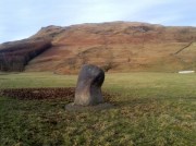
Loch Ardinning, Mugdock, Stirlingshire

Cup-and-Ring Stone (lost):  OS Grid Reference – NS 56 77

Archaeology & History

The hidden Loch Ardinning stone

The hidden Loch Ardinning stone

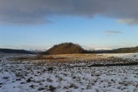
This site-profile is one for the explorers amongst you.  It was last reported by the rock art author Ronald Morris (1981) who himself looked several times for this multiple-ringed carving, but never managed to find it.  The carving was rediscovered and described by the Glasgow archaeologist J. Harrison Maxwell, who took the only known photograph of the carving (reproduced here).  Sadly, he only left a short note about the site which read simply: “cups-and-rings to the west of Loch Ardinning.”

It seems probable that the carving would be in the area between the loch and the A81 road (between Strathblane and Bearsden) and not on the western side of the road—but we cannot be certain.  It may be hidden in the trees somewhere between the road and the lochside—which means that it’s probably completely overgrown by vegetation.  Morris (1981) described the carving as:

“a cup-and-four-rings, 2 cups-and-two-rings, and at least 4 cups-and-one-ring. Some rings are complete without radial groove and some are gapped with groove from the cup.”

If any explorers out there manage to unearth this lost carving, please give us a shout!

References:

  1. Morris, Ronald W.B., “The Cup-and-Ring and Similar Early Sculptures of Scotland; Part 2 – The Rest of Scotland except Kintyre,” in Transactions of the Ancient Monuments Society, volume 16, 1969.
  2. Morris, Ronald W.B., “The cup-and-ring marks and similar sculptures of Scotland: a survey of the southern Counties – part 2,” in Proceedings of the Society of Antiquaries, Scotland, volume 100, 1969.
  3. Morris, Ronald W.B., The Prehistoric Rock Art of Southern Scotland, BAR: Oxford 1981.

© Paul BennettThe Northern Antiquarian


Echo Stone, Mugdock, Stirlingshire

Legendary Rock (destroyed):  OS Grid Reference – NS 5493 7710

Also known as:

  1. Historic Environment Record Stirling 3745

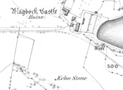
Echo Stone on 1865 Map

Echo Stone on 1865 Map

Archaeology & History

A recent communication to us from Alan McBride (2021), the historian for the Mugdock Country Park, has given us an accurate appraisal of this site which has, sadly, passed into the Realm of the Lost.  The following paragraphs are what Mr McBride has discovered in his personal exploration looking at the history of this once legendary stone.  He writes:

“As the name suggests, one would stand at, or on, the Echo Stone facing Mugdock Castle and upon shouting the voice would reverberate off the high walls of the castle and come back as a long clear echo.  It was a feature on Montrose’s estate, but when it came into existence is unknown.  Historical maps give an idea of when it disappeared though.  The Ordnance Survey map of 1860 shows the Echo Stone adjacent to Mugdock Castle in open ground (now woodland) close to the boundary of Mugdock Wood at the steep crag.  The Ordnance Survey map revision of 1896 shows the Echo Stone and in brackets (site of) and the area planted as woodland.

“Put into historical context, the map of 1860 was produced not long after Archibald McLellan’s tenancy at Mugdock Castle, at which point the old Georgian house was still standing. By the time the revised map of 1896 was produced, John Guthrie-Smith was the tenant of Mugdock Castle.  He was responsible for demolishing the old Georgian house and building the Victorian mansion in its place.  He was also responsible for the design and planting of many trees in the areas surrounding Mugdock Castle and Loch, one of these areas being where the Echo Stone was located.  It is believed by local historians that the stone, decorated with engravings, was either stolen during the time the castle and estate was vacant after McLellan’s death, that it was pushed over the crag into Mugdock Wood where it remains buried under vegetation, or that it was removed during the planting of the area by Guthrie-Smith.”

Of particular interest to myself (PB) is the mention of it being “decorated with engravings.”  My first response (obviously!) was that such carvings may be prehistoric.  A short distance east of here—and also lost—was the Loch Ardinning cup-and-ring stone, so our Echo Stone may have been a carved compatriot.  When I enquired about this, Mr McBride told me,

“Regarding the stone being decorated with engravings, this was a local historian who told me this many years ago. He had been told himself, when he was younger, that the Echo Stone would have been a feature seen from the castle and therefore had decorative features on it.  He has since passed away and it is the only reference I’ve had to it being decorative.  It would make sense though.”

An early literary record of the stone can be found in Hugh MacDonald’s (1854) work, in which he wrote:

“There is an echo of considerable local celebrity at Mugdock, the reverberative powers of which are frequently put to the test by visitors. The spot from which the echo is most distinctly heard is a slightly projecting rock, on a verdant declivity, about a hundred yards to the south of the castle. A person standing on this, looking towards the edifice, and speaking pretty loudly, will hear his words, or even short sentences uttered by him, repeated with startling distinctness, as if from some mimic at the old tower. Of course, we give the echo sundry specimens of our vocality, and to its credit we must say that it flings them back with amazing fidelity. Paddy Blake’s echo, which on the question being put to it of ‘How are you?’ invariably answered ‘Pretty well, I thank you!’ was unmistakeably a native of the land of Bulls. The Mugdock one must be as decidedly Scottish, as it answers each question put to it by asking another. If there were any doubt on this subject, however, we might mention, in support of our supposition, that it is quite au fait at the Gaelic, as we proved to the entire satisfaction of a cannie bystander, who, after listening in silence for some time to our mutual interrogations in that classic tongue, at length exclaimed, ‘Od, man, that’s curious! Wha wad hae thocht that a Lawlan’ echo could hae jabbered Gaelic?'”

Samuel Lewis, writing before 1846, told us that,

“At a distance of about 300 yards from this castle is a remarkable echo, which distinctly reverberates a sentence of six monosyllables, if uttered in a loud tone; and this not till a few seconds after the sentence is completed”.

We can only speculate as to how people in distant times reacted to this echo, and it is interesting how MacDonald’s Gaelic-speaking friend reacted, almost as if he believed it to be a living organism which he did not expect to reply in his own language.

References:

  1. McBride, Alan, Personal Communication, April 15, 2021
  2. MacDonald, Hugh, Rambles Round Glasgow, Descriptive, Historical & Traditional, John Smith & Son: Glasgow 1854 & 1910.
  3. Lewis, Samuel, A Topographical Dictionary of Scotland – 2 volumes, S Lewis & Co.: London 1846

Links:

  1. Mugdock Country Park

Acknowledgements:  Huge thanks to Alan McBride for the revisions and corrections regarding this site profile.

© Paul Bennett, Paul T. Hornby & Alan McBride, The Northern Antiquarian 2016


Strathblane Churchyard, Stirlingshire

Standing Stone:  OS Grid Reference – NS 56387 79375

Also Known as:

  1. Canmore ID 44452

Getting Here

Strathblane church's heathen creator

Strathblane church’s heathen creator

From whichever direction you’re coming from along the A81 into Strathblane, make sure you keep your eyes peeled for where the A891 turns off it to the east.  Go  and along there and barely 100 yards on the church is set back from the road.  Walk into the graveyard, turn left and you can’t really miss it amidst the mass of modern graves.

Archaeology & History

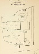
Location of the stone, from Smith 1886

Location of the stone, from Smith 1886

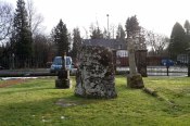
In accordance with the occasional tradition of standing stones in churchyards (such as the Rudston monolith and many others), a short stumpy monolith, less than four feet high, here stands alone in the christian burial ground surrounding Strathblane’s parish church.  The top of the stone is quite flat and it’s possible that this once stood much taller, with the top of the stone being chopped off (such destruction has happened at the Cuckoo Stones and many other megalithic sites).  It’s certainly worth looking at and stands amidst a cluster of other ancient sites—some gone, some still in evidence—in and around this lovely old village.  Not much has been written about the stumpy little fella and its first literary reference seems to be in Mr Smith’s (1886) magnum opus on the area, where he tells:

“There is a very old standing stone in the churchyard, but most probably it was placed there long before there was any church in the parish.”

…Nothing else.  Even the Royal Commission (1963) lads said little about it, merely telling us:

“A few yards within the entrance to the graveyard of Strathblane Parish Church…a standing stone appears among the monuments.  It is a five-sided pillar, 3ft 9in high, with an uneven but flattish top.  At ground level the sides range from 1ft 9ins to 2ft 3in in width.”

The stone, looking south

The stone, looking south

The stone, looking southeast

The stone, looking southeast

The fact that it stands by the church (rebuilt around 1803 out of its more ancient fabric) suggests that the site was a heathen temple or sacred site, redesignated by the invading christian priesthood.  A short distant east and west have been found a number of prehistoric remains in the forms of burials, standing stones and giant cairns, indicating this site to have had particular mythic importance in earlier centuries.  From the standing stone if we look southeast, we see the rise of Dunglass, but the view to the stones and great pyramid of Dumgoyach, northwest, is blocked by the rise of Cuilt Brae, which I found to be a little surprising.

References:

  1. Royal Commission on the Ancient & Historical Monuments Scotland, Stirling – volume 1, HMSO: Edinburgh 1963.
  2. Smith, John G., The Parish of Strathblane, James Maclehose: Glasgow 1886.
  3. Ure, David, The History of Rutherglen and East Kilbride, Glasgow 1793.

© Paul BennettThe Northern Antiquarian


Broadgate Farm, Strathblane, Stirlingshire

Standing Stone:  OS Grid Reference – NS 56929 79402

Also Known as:

  1. Canmore ID 44439

Getting Here

Broadgate Farm standing stone

Broadgate Farm standing stone

From Strathblane, take the A891 road eastwards out of the village, past the standing stone in the churchyard and the row of houses set back off the road until, a few hundred yards along, the fields open up on both sides of you.  In the very first field on the north side of the road, you’ll see the standing stone, all alone, resting quietly.  There’s a gate enabling you access into the field…

Archaeology & History

Broadgate Stone, with Dunglass SE

Broadgate Stone, with Dunglass SE

Found in close proximity to the destroyed chambered tomb of Broadgate, this small standing stone is presently set in a concrete base after an excavation here in 1982 located a cremation urn beneath the stone, confirming an old tradition that told as much.  But there are some who think the stone isn’t a prehistoric one—the Royal Commission (1963) lads for one.  In their brief resumé of the site they wrote:

“This stone stands just N of the road from Campsie to Strathblane, 140 yds E of Broadgate farmhouse.  It is 4ft high and measures 2ft 3inches by 3ft at ground level.  It may well be the stone referred to in the New Statistical Account as marking the spot where Mr Stirling of Ballagan was murdered in the 17th century and should therefore not necessarily be accepted as of prehistoric origin.”

And were it not for an excavation nearly twenty years later, this view may have been maintained.  However, when Lorna Main (1982) told of what was found beneath the monolith, no mention was made of any recent remains.  She wrote:

“Excavation at the base of the fallen standing stone was undertaken prior to its re-erection. A ledge had been cut on the south-west side of the shallow stone hole and fragments of the base survived and the diameter of the base is approximately 17cm.  The urn contained a cremation and a small quantity of charcoal.  It lay only 15cm below the ground surface and is in a poor condition.”

The very fragile state of the urn and the very eroded rounded stature of the rock itself would seem to indicate that this is more a prehistoric upright than a later 17th century one.

Folklore

There are legends of early battles in this region and J.G. Smith (1886) thought that perhaps “this great stone…mark the resting-places of Cymric heroes who did their share of the battle on the north side of the valley.”

References:

  1. Main, Lorna, “Broadgate Farm – Standing Stone and Cinerary Urn,” in Discovery & Excavation Scotland, 1982.
  2. Royal Commission on the Ancient & Historical Monuments Scotland, Stirling – volume 1, HMSO: Edinburgh 1963.
  3. Smith, John G., The Parish of Strathblane, James Maclehose: Glasgow 1886.
  4. Ure, David, The History of Rutherglen and East Kilbride, Glasgow 1793.

© Paul BennettThe Northern Antiquarian


Broadgate, Strathblane, Stirlingshire

Chambered Cairn (destroyed):  OS Grid Reference – NS 5674 7938

Also Known as:

  1. Canmore ID 44453

Archaeology & History

A once-impressive large prehistoric long cairn could be found close to the grid-reference given here, whose existence and destruction was recorded, thankfully, by local antiquarians in the 18th and 19th centuries respectively.   There are remains of other prehistoric sites in and around the spot—including the standing stones of both Broadgate Farm and Strathblane Church—close to which Mr J.G. Smith (1866) described,

“towards the end of last century a mound was levelled at Broadgate near this spot, and many stone coffins, each containing an urn full of earth and burnt bones, were found.”

Smith himself refers to the lengthier description of the mound’s destruction in Ure’s History of Rutherglen (1793), in which the site was described as

“an ancient burying place, the origins of which is unknown, was 60 yards in length, 14 feet in height, and of a considerable breadth.  It was composed of gravel, and lay east and west.  In the bottom were a great many coffins of stone, placed in a row, and separated from one another by a single flag.  Every coffin contained an urn, that was full of earth and burnt bones.  Beside each urn was a pillar about 3 feet in height, and 8 inches in thickness.  They were fragments of basaltic five-sided columns, a few rocks of which are found in the parish.  Most of the pillars are built in a dyke adjoining to the church.  The urns on being touched fell in pieces.”

Due to the seemingly extravagant lay-out of this cairn, Audrey Henshall (1972) took the site to be a chambered tomb of some considerable importance.  She was probably right!  In her magnum opus (1972) on the subject she wrote:

“The description of the ‘cists’ suggests a segmented chamber of Clyde type, but the mound composed of gravel (instead of being a cairn) suggests a natural feature.  A long mound, probably natural, exists on Broadgate Farm in which a restricted excavation produced a cist of Bronze Age type. Possibly the Strathblane mound was similar; it may have contained a segmented chamber (…where a chamber has been built into a natural mound), or it may have contained cists of later type for single burials.”

Subsequent explorations by the Royal Commission (1963) and local historians to find any remains of the site have proved fruitless.

References:

  1. Henshall, Audrey S., The Chambered Tombs of Scotland – volume 2, Edinburgh University Press 1972.
  2. Royal Commission on the Ancient & Historical Monuments Scotland, Stirling – volume 1, HMSO: Edinburgh 1963.
  3. Scott, J.G., “Inventory of Clyde Cairns,” in Megalithic Enquiries in the West of Britain,Liverpool University Press 1969.
  4. Smith, John G., The Parish of Strathblane, James Maclehose: Glasgow 1886.
  5. Ure, David, The History of Rutherglen and East Kilbride, Glasgow 1793.

© Paul BennettThe Northern Antiquarian


Dumgoyach Stones, Strathblane, Stirlingshire

Standing Stones:  OS Grid Reference – NS 53269 80727

Also Known as:

  1. Canmore ID 44605
  2. Dungoiach
  3. Duntreath

Getting Here

Approaching Dumgoyach Hill

Approaching Dumgoyach Hill

You can either find your way to Duntreath Castle on the western edges of Strathblane and walk SW straight up the steep grassy slope next to the wooded Dumgoyach Hill; or… From Carbeth, north along the A809, turn right up the B821 Ballachalairy Yett road for 1km and park where the path of the West Highland Way runs onto the hills. Follow this path for nearly ½-mile and where the path splits, bear left.  Keep walking downhill for a few hundred yards, then go off-track towards the copse of trees. Climb over the gate and onto the grassy plain between this copse and the huge rounded Dumgoyach Hill.  The stones are very close indeed…

Archaeology & History

This is a truly stunning site – not as much for the megaliths that are here, but for the setting in which they’re held.  “Magnificent” is the word that rolled out of my mouth a number of times; whilst respected activist and ‘Organic Scotland’ creator Nina Harris said, quite accurately, “it’s Caras Galadhon in Lothlorien!” (or words to that effect) – and she hit the nail much better than I did!

Royal Commission 1963 sketch

Royal Commission 1963 sketch

Dumgoyach Stones (by Nina Harris)

Dumgoyach Stones (by Nina Harris)

A short line of large standing stones remains here, both upright and leaning, running NE-SW for 7 yards: seemingly a part of some other much larger monument in times long past—although very little else remains.  The stones are set upon a rise of land, quite deliberately in front of Dumgoyach Hill (or Lothlorien, as Nina called it) almost as a temple or site of reverence.  You’ve gotta see it to appreciate what I’m saying!  Like some gigantic tree-covered Silbury Hill, the standing stones on this ridge possess an undoubted geomantic relationship with this rounded pyramid, all but lost in the sleep of local myths and land.  A few yards away from the line of stones there is a slight rise in the land, seemingly giving weight to the idea that something else was living here: an architectural feature that Aubrey Burl (1993) thinks might have been “the facade of a chambered tomb” (neolithic in origin) and not merely a megalithic alignment.  He may be right…

Close-up of the megaliths

Close-up of the megaliths

Described briefly in J.G. Smith’s (1886) magnum opus on the Strathblane parish, antiquarian accounts of this impressive site seem curiously rare.  One of the earliest recognised accounts was done by the Royal Commission (1963) lads who measured the site up with their usual diligence.  Although getting the alignment of the stones wrong, the rest of their survey seems pretty accurate. They told that,

“There are five standing stones (A-E) arranged in a straight line… Three of the stones (A, B and C) are earthfast, while the other two (D and E) are recumbent.  Stone A is of irregular shape and leans steeply towards the N.  The exposed portion measures 4ft in height, 2ft 6in in breadth and 1ft 2in in thickness.  Stone B stands upright, 6ft NE of A.  It is a pillar of roughly rectangular section with an irregularly pointed top, and measures 5ft in height by about 2ft 6in in thickness.  Stone C, also irregular in shape, 11ft 6in NE of B, is inclined so steeply to the NNE that it is almost recumbent.  It measures 4ft 4in in height, 2ft 6in in breadth and 1ft in thickness. The remaining two stones lie on the ground between B and C.  Stone D measures 5ft 5in in length, 3ft in breadth and 1ft 6in in thickness while stone E, which rests partly on D, measures 7ft 10in in length, 3ft 9in in breadth and 3ft in thickness.”

Aubrey Burl’s (1993) description of the site—which he called Blanefield—is another good synopsis of what is known historically and astronomically about the site.  Assessing them in his detailed work on megalithic alignments, he said that,

“At Blanefield near Strathblane in Stirling a big stone, its longer sides aligned east-west, stands at an angle amongst a southwest-northeast line of four others, fallen, of which one just off the line seems to have been added this century.  The setting has been presumed a collapsed four-stone row.  Known also as Duntreath and Dumgoyach, the setting is slightly concave.

“‘This ruinous alignment indicates notches to the northeast and these show approximately the midsummer rising sun.’ ‘The standing stone has a flat face exactly aligned on a hill notch to the east,’ quite neatly in line with the equinoctial sunrises.  These astronomical analyses would seem to confirm that Blanefield was undoubtedly a row set up by prehistoric observers to record two important solar events.

“Excavation in 1972 discovered signs of burning, flints and charcoal that yielded a C-14 assay of 2860±270 BC (GX-2781), c. 3650 BC, a time in the Middle Neolithic when chambered tombs were still in vogue, but an extremely early date for any stone row.  This, coupled with Blanefield’s isolated position for a row in central Scotland, raises doubts about its origins.

“It is a lonely megalithic line, those nearest to it being over forty miles (64km) to the west in Argyll.  Straddling a ridge overlooking the Blane Water it is arguable that the stones are relics of the crescent facade of a Clyde chambered long cairn with an entrance facing the southeast….”

Dumgoyach Stones, with Dumgoyne to the North

Dumgoyach Stones, with Dumgoyne to the North

However, there was once another stone row close by, known as the old Stones of Mugdock.  Burl then cites the proximity of four nearby neolithic long cairns not too far away, with the Auchneck tomb just 3½ miles (5.6km) to the west; although it seems that Nina Harris may have discovered another one, much closer still (TNA will have a preliminary report on this in the coming months).

Folklore

Local legend reputes that King Arthur was up and about in this part of the world, fighting in a battle nearby.  And in J.G. Smith’s (1886) excellent work on the parish of Strathblane, he told that,

“The standing stones to the south-east of Dungoyach probably mark the burial place of Cymric or Pictish warriors who fell in the bloody battle of Mugdock.”

References:

  1. Burl, Aubrey, From Carnac to Callanish, Yale University Press 1993.
  2. Feachem, Richard, Guide to Prehistoric Scotland, Batsford: London 1977.
  3. Heggie, Douglas C., Megalithic Science: Ancient Mathematics and Astronomy in Northwest Europe, Thames & Hudson: London 1981.
  4. MacKie, Euan W., Scotland: An Archaeological Guide, Faber: London 1975.
  5. Ritchie, J.N.G., “Archaeology and Astronomy,” in Heggie, D.C., Archaeoastronomy in the Old World, Cambridge University Press 1982.
  6. Royal Commission on the Ancient & Historical Monuments Scotland, Stirling – volume 1, HMSO: Edinburgh 1963.
  7. Smith, John G., The Parish of Strathblane, James Maclehose: Glasgow 1886.
  8. Thom, Alexander, Megalithic Sites in Britain, Oxford University Press 1967.
  9. Thom, A., Thom, A.S. & Burl, Aubrey, Stone Rows and Standing Stones – volume 1, BAR: Oxford 1990.

Acknowledgements:  A huge thanks to Nina Harris, of Organic Scotland, for both taking me to these stones and sharing her photos for this site profile.  Cheers Nina!

© Paul BennettThe Northern Antiquarian