Market Cross, Lechlade, Gloucestershire

Cross (destroyed):  OS Grid Reference – SU 214 995

Archaeology & History

In days of olde, Charles Pooley (1868) told us that “an old cross formerly stood in the Market-place” in the centre of the town where the old crossroads meet—as was customary for crosses and maypoles—just outside the church of St. Lawrence.  Pyramidal in form, it was mentioned in an old manuscript cited by Adin Williams (1888), which told us,

“Leland saith that in his days there was a Piramid of Stone at ye west end of ye Church, whose foundations are to be seen near Slaughter’s Well, which is said to be medicinal water.”

And although we don’t know when the cross was erected, we know when it was destroyed.  Williams again tells us:

“About 1770, Sir Jacob Wheate pulled down this cross.  He is said to have taken the stones to the house he was building.”

References:

  1. Pooley, Charles, Notes on the Old Crosses of Gloucestershire, Longmans Green: London 1868.
  2. Williams, Adin, Lechlade: Being the History of the Town, Manor and Estates, The Priory and the Church, E.W. Savory: Cirencester 1888.

© Paul BennettThe Northern Antiquarian

Village Cross, Deerhurst, Gloucestershire

Cross (destroyed):  OS Grid Reference – SO 870 299

Archaeology & History

In Charles Pooley’s (1868) definitive account of Gloucestershire county crosses, he informs us that,

“there was formerly a Cross erected in this village, but it has long since disappeared.”

He gives no further information about its history, but we must surmise that it was either associated with the ancient priory on the north side of the village, or in the traditional place at the centre of the the village. The grid-reference cited places the lost cross in the grounds of the priory.

References:

  1. Pooley, Charles, Notes on the Old Crosses of Gloucestershire, Longmans Green: London 1868.

© Paul BennettThe Northern Antiquarian

Churchyard Cross, Lower Dowdeswell, Gloucestershire

Cross (destroyed):  OS Grid Reference – SP 001 199

Archaeology & History

In Charles Pooley’s (1868) definitive history on the county crosses, this monument is mentioned in passing without any known history, apart form it been destroyed sometime in the early 19th century:

“A cross formerly stood in the churchyard, but it has been removed within living memory.”

References:

  1. Pooley, Charles, Notes on the Old Crosses of Gloucestershire, Longmans Green: London 1868.

© Paul BennettThe Northern Antiquarian

Village Cross, Powerstock, Dorset

Cross (destroyed):  OS Grid Reference – SY 5167 9622

Archaeology & History

This old cross was almost lost to history, but thanks to personal notes written by one John Banger Russell in 1780, we’ve been left with a description of the monument, which Alfred Pope (1906) published in his survey:

“In the middle of this parish are the remains of a large cross, which has been much injured by time.  The shaft, which seems to have been of considerable height, has been taken down, tho’ the base or pediment still continues in its proper place.  The ascent was by four steps but the whole is very ruinous.”

Nearly a hundred years later in the hugely updated magnum opus of John Hutchins (1863), the site had long gone:

“A mutilated cross which stood in the centre of the village at the beginning of the present century, has since been destroyed.”

References:

  1. Hutchins, John, The History and Antiquities of the County of Dorset – volume 2, Bowyer & Nichols: London (3rd edition) 1863.
  2. Pope, Alfred, The Old Stone Crosses of Dorset, Chiswick Press: London 1906.

© Paul BennettThe Northern Antiquarian

The Cross, Gussage All Saints, Dorset

Cross (destroyed):  OS Grid Reference – ST 999 108

Archaeology & History

In days of olde an old stone cross used to stand “at the crossroads just outside the churchyard,” wrote Alfred Pope (1906); but even in his day he told that “the cross has long since disappeared.”  He continued:

“The Rev A.S.B. Freer, vicar, informs the writer that the site is still known as ‘The Cross’, and is never called by any other name by the villagers.”

The church in the village is dedicated to All Saints, whose festival date was known in older times to be the pre-christian New Year’s Eve, or Halloween, when the spirits of the dead move across the landscape.

References:

  1. Pope, Alfred, The Old Stone Crosses of Dorset, Chiswick Press: London 1906.

© Paul BennettThe Northern Antiquarian

St. Andrew’s Cross, Dunfermline, Fife

Cross (destroyed):  OS Grid Reference – NT 1017 8630

Also Known as:

  1. Canmore ID 50858

Archaeology & History

In Pete Chalmers (1844) historical brief about the long lost chapel and hospital of St. Leonard (and its associated holy well), mention is made of this long forgotten relic.  Its memory was preserved in an old place-name, and was to be found less than half-a-mile southeast of St. Leonard’s sites on,

“the high part of the road, about a quarter of a mile to the south, the Spital-Crosshead, (named) from a pillar which, according to tradition, was erected there, decorated on the top by a St Andrew’s Cross, and removed probably towards the close of the 16th or 17th century.”

The cross is believed to have been erected in the 15th century.

References:

  1. Chalmers, Peter, Historical and Statistical Account of Dunfermline, William Blackwood: Edinburgh 1844.

© Paul BennettThe Northern Antiquarian

Kendal Maypole, Kendal, Westmorland

Maypole (destroyed):  OS Grid reference – SD 5161 9212

Archaeology & History

Long since gone, it’s existence was recorded by, amongst others, the Kendal historian Cornelius Nicholson. (1861)  He described it in relation to one of the town crosses, that was removed due to it being “an obstruction in the street.”  The maypole too, he said,

“was another incumbrance, but indispensable, according to the custom of our forefathers.  It stood in Kirkland, opposite the house of the late Thomas Reveley, Esq., and was suffered to remain till within eighty years ago.  In the time of our good Queen Katherine, who may fairly be supposed to have partaken of the amusements, countenanced by her royal consort, the original festivity of maying and morris-dancing would be here celebrated, by the annual ceremony of “maying” when, immediately after sunrise, on the 1st of May, processions, entering the town at various inlets, streamed through the streets, with music of horns and flutes; boys with their May-gads (willow-wands twined with cowslips), and girls with their “brats” full of flowers — young and old alike joining in merry laughter, and song, and the customary chorus, “We have brought the summer home.”  When the above-named ceremonies became less fashionable, the May Pole was made the rendezvous of all the milkmaids in the neighbourhood, who came and paraded round it on Easter Mondays.  On other occasions of rejoicing, afterwards, such for instance, as terminating an apprenticeship, and the like, it became customary for young men to go and dance around it.”

The author then told that this annual village ceremony was still being performed at the beginning of the 19th century, “in the assemblage of young people in the Vicar’s Fields, on Easter Tuesday.  After spending the afternoon there, they returned in procession through the streets, threading grandy needles.”

References:

  1. Nicholson, Cornelius, The Annals of Kendal, Whitaker & Co.: London 1861.

© Paul BennettThe Northern Antiquarian

St James’ Cross, Barton-upon-Humber, Lincolnshire

Cross (destroyed):  OS Grid reference – TA 0424 2064

Archaeology & History

This long lost wayside cross was described in various local records from 1621 upwards.  In the definitive place-name survey of this area, Kenneth Cameron (1991) told us that this was,

“A medieval cross dedicated to St James, situated at the point where the Thornton and Burnham roads meet… Mr R. Newton comments, “said to have replaced a wayside shrine.  The foundations of the shrine were exposed when the Home Guard dug a defensive trench there at the beginning of the last war.  Foundations destroyed by a bomb.””

References:

  1. Cameron, Kenneth, The Place-Names of Lincolnshire – volume 2, EPNS: Nottingham 1991.

© Paul BennettThe Northern Antiquarian

Dawe’s Cross, Cambridge, Cambridgeshire

Cross (destroyed):  OS Grid Reference – TL 455 578

Archaeology & History

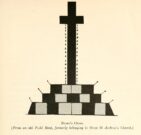
This is one of several medieval stone crosses in Cambridge that were destroyed several centuries ago.  This particular one was erected on a three-stepped stone base at the old crossroads where, today, the modern A1307 of Regent Street meets the A603 Lensfield Road.  It was described in an old Field Book of 1575 as standing being beside an old poplar tree, long gone.  Mr H.P. Stokes (1915) gave us a short account of the site, telling:

“In describing the lane called “Deepway” between the London Road and the Hadstock Way and known as “King’s Lane” from the latter road to Hinton Way, mention was made of a Cross (called Dawe’s Cross) which stood at what is now known as Hyde Park Corner.  Dawe’s Cross is often mentioned in ancient deeds, and in an old Field Book, which formerly belonged to the vestry of the Church of St Andrew the Great, there was a most interesting representation of it.  This is here reproduced…from a copy in the celebrated Bowtell MSS.”

The cross stood along one of Alfred Watkins’ (1932) “archaic tracks”, or leys, in this area—although he wasn’t aware of its existence.

References:

  1. Stokes, H.P., Outside the Barnwell Gate, Cambridge Antiquarian Society 1915.
  2. Watkins, Alfred, Archaic Tracks round Cambridge, Simpkin Marshall: London 1932.

© Paul BennettThe Northern Antiquarian

Bradshaw Cross, Long Lane, Nether Wyresdale, Lancashire.

Wayside cross: OS Reference – SD 52474 51414

Also Known as :

  1. Historic England Grade II Listed Building No. 1163927 

Getting Here

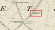
Cross shown on 1846 map

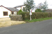
Follow Long Lane northwards from Scorton, over the crossroads at Crosshill Four Lane Ends, and the cross base will be found at the road edge immediately to the right of the driveway of ‘Sandalwood’ on the left hand side of the road.

Archaeology & History

Described in the Historic Buildings listing citation as:

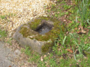
“Cross base, probably mediaeval. A sandstone boulder, roughly rectangular, with rectangular socket.”

Cross base at the roadside
‘A sandstone boulder, roughly rectangular’

The base of one of the numerous mediaeval wayside crosses that once adorned this part of Lancashire. So what happened to the cross? It’s possible that it was wilfully destroyed in the early nineteenth century as we have a likely culprit in the person of the Reverend Richard ‘Cross Smasher’ Wilkinson (c.1791 – 1823), Curate of Whitechapel, who took it upon himself to destroy the symbol of his religion wheresoever he could find it.

Immediately to the north west of the Cross is Cross Hill.  The cross itself was probably a waymarker on the road over Harrisend Fell from Oakenclough, and Bradshaw may be the name of the locality, there being a Bradshaw Bridge just outside Street to the north west, while the 1846 6-inch OS map records a ‘Bradshaw Smithy’ on the same road.

Note: More has been recorded about Wilkinson in the profile of Stump Cross, near Goosnargh.

Reference:

  1. Taylor, Henry, The Ancient Crosses and Holy Wells of Lancashire, Sherratt and Hughes, Manchester, 1906

© Paul T Hornby, The Northern Antiquarian, 2020