Stone Circle: OS Grid Reference – SE 8719 9338

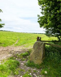
From Pickering, take the A169 towards Whitby. When you get to the Car Park at the ‘Hole-of-Horcum’ – (you can’t miss it), park the car and walk North along the side of the road towards Whitby. After 60 yds, take the track East. Follow this for approximately a mile until the track splits. Take the concrete track left towards the farm-house of ‘Newgate Foot’. Go through the yard past the house on the right, and you will come to a stream and a gate. Enter the field on the right and up the track. The stones are in front of you.
Archaeology & History
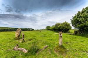
The great rounded hill of Blakey Topping—recorded as early as 1233 CE and meaning the ‘black mound’ or ‘black meeting-place’— has the ruins of a stone circle living several hundred yards to its south, little-known to many. The early writer George Young (1817) seemed to come close here, mentioning the ‘druidic’ standing stones of Blakey Moor and district, but gave no specific indication of the ruinous ring we’re visiting here. Instead, the first real description was penned by Robert Knox (1855) who, at the time of writing, was under the academic spell of druidism: prevalent as it was amongst most universities and places of learning back then. Also, beset by the equally sad plague of Biblical comparitivism—beloved even to this day by halfwits—Knox’s formula about this ancient ring was founded on the druidical reverence of Blakey Topping as a site beneath which our Bronze age tribal ancestors erected their stones with the rounded hill immediately to the north, as signified by its early name, black. (In early place-names, ‘black’ and its variants—dubh, dove, etc—relates to the cardinal direction of ‘north’ and actually means ‘shining’; and white or ban is ‘south’, when both elements are located in relative proximity.) Knox told us:
“At the southwest side of this arch-Druid’s tomb-like hill (Blakey Topping) a far more conspicuous cluster of larger Druid stones occurs; here three pillars form a triangle…and a smaller one…stands one hundred and fifty paces east of these nearer to the farmhouse there. These single stones, possibly, once formed part of a circle… The diameter of a circle formed on this triangle of stones would be about fifty-five feet; but as these pillars form a nearly equilateral triangle, the number of stones in that circle cannot now be correctly ascertained, if, indeed, they ever formed part of a circle…
“These three sandstone pillars, untouched by tools…are much weather-worn; and hence it may be inferred that they are very ancient. I shall only add that the tallest pillar here is nine feet high, from two-and-a-half to three feet wide, and rom fifteen to twenty inches thick, and is the tallest ancient pillar next to the celebrated one in Rudston churchyard, now standing in the eastern part of Yorkshire. When I last visited the Blakey Topping Druid-stones in 1836, I learned that the farmer, on whose ground they stand, “had talked about breaking the three large ones to pieces,” and perhaps nothing but the trouble of doing so has hitherto preserved them, and many others. I told him what had been their use, and begged he would preserve them.”

And thankfully they remain there to this day! Around the same time of Mr Knox’s visit, the Ordnance Survey lads came here too and, in 1854, highlighted the remaining ‘Druidical Stones’ on the first map of the area. But references to the stones from here onwards are sparse and add nothing pertinent to its archaeomythic status. It was a Mr & Mrs Elgee (1930) who were the next to tell us about the site in their exposition on Yorkshire archaeology. They wrote:
“Three large standing stones about 6 feet high on the south-west side of Blakey Topping…are the remains of a circle about 18 yards in diameter. Two or three hollows in the ground indicate the position of other stones, some of which are serving as gateposts nearby. Others have been broken up to help build a wall. These stones are associated with a large settlement sites similar to (one) on Danby Rigg not very far from the imposing Bridestones and approached by an ancient trackway known as the Old Wife’s Trod.”
The general interpretation by the great megalithic archaeologists Aubrey Burl, John Barnatt and their fellow associates, is that these stones are the remains of a stone circle – which seems apt. But of even greater importance seems to be the great hill of Blakey Topping itself, to which this olde ring no doubt related to. Many other prehsitoric sites once scattered this area, but sadly most of them have been destroyed.
References:
- Barnatt, John, Stone Circles of Britain (2 volumes), BAR: Oxford 1989.
- Burl, Aubrey, A Guide to the Stone Circles of Britain, Ireland and Brittany, New Haven & London 1995.
- Burl, Aubrey, The Stone Circles of Britain, Ireland and Brittany, Yale University Press 2000.
- Elgee, F., Early Man in Northeast Yorkshire, Frank Bellows: Gloucester 1930.
- Elgee, F. & H.W., The Archaeology of Yorkshire, Methuen: London 1933.
- Gutch, Mrs E., Examples of Printed Folklore Concerning the North Riding of Yorkshire, David Nutt: London 1899.
- Knox, Robert, Descriptions Geological, Topographical and Antiquarian in Eastern Yorkshire, London 1855.
- Phillips, Guy Ragland, Brigantia, RKP: London 1976.
- Smith, A.H., The Place-Names of the North Riding of Yorkshire, Cambridge University Press 1928.
- Spratt, D.A., Prehistoric and Roman Archaeology of North-East Yorkshire, BAR: Oxford 1982.
- White, Stanhope, Standing Stones and Earthworks on the North Yorkshire Moors, privately printed: Scarborough 1987.
- Young, George, A History of Whitby and Streoneshalh Abbey – 2 volumes, Clark & Medd: Whitby 1817.
Links:
Acknowledgements: Big thanks to the photographer James Elkington, for use of his photos in this profile. Cheers mate. Also, accreditation of early OS-map usage, reproduced with the permission of the National Library of Scotland.
© Paul Bennett & James Elkington, The Northern Antiquarian
The map could not be loaded. Please contact the site owner.