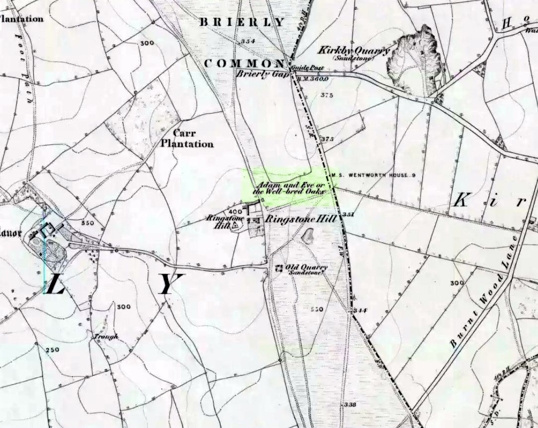
Highlighted on the 1854 Ordnance Survey map close to the township boundary line as Adam & Eve’s Oak, between Brierley and South Kirkby, I can’t find too much about this once great tree. However the Wakefield historian W.S. Banks (1871) told us the following:
“Upon the common at Ringston Hill grows the remarkable ‘old Adam’ oak, much decreased in size in late years. It is an ancient and large tree measuring twenty-seven feet in girth at a yard above the ground. The trunk is hollow and the north side is broken away. Most of the branches are also gone. In 1868 a very large branch was blown off by the wind; but on the southerly side are still some very vigorous limbs.”
The old oak on the 1854 map
Even when Banks wrote this he said how the tree “must be many centuries old.” In the time of King Charles II there used to be an old inn by Adam’s Oak at the foot of Ringston Hill, where the famous highwayman, Nevison (much-loved by many Yorkshire-folk because of his Robin-Hood-like character), used to stay. The inn was owned by one Adam Hawksworth, but was ordered “to have his sign taken down for harbouring Nevison.”
Folklore
W.S. Banks also wrote of this once great tree:
“The people at Brierley tell of Nevison the highwayman lodging in it and hiding stolen treasures in it, things which probably did not happen, though Nevison’s name is connected with Ringston Hill.”
The treasure legend may have more to do with the adjacent stone circle, as we find ‘treasure’ a common motif at such places.
References:
Banks, W.S., Walks in Yorkshire: Wakefield and its Neighbourhood, Longmans, Green Co.: London 1871.
Thor Stone, Taston, hiding in shadows on bright sunny day
Very easy! From which ever direction you approach the gorgeous little village of Taston, get to the Cross in the middle of the road and look up the slight hill and at the old walling on the right-hand side. You can’t really miss it!
Archaeology & History
An impressive seven-foot tall standing stone resting up against the walling of Martin and Martha’s Thorstone Cottage, and which appears to have been recorded as far back as the late thirteenth century in the survey of the Chadlington hundred. Indeed, according to the respective place-name authorities, the village of Taston itself appears to get its name from the Thor Stone, as it’s recorded as Thorstan in 1278 CE. (Gelling 1954)
Less than 100 yards away is a large old stone cross, the top of it now fallen, which may once have had some earlier pre-christian relationship with the Thor Stone; perhaps originating from other standing stones close by our now solitary Thor Stone (see Folklore, below). No other monoliths or prehistoric tombs are presently associated with this site, but its folklore tells of earlier companions…
More than a hundred miles north of here we find an etymological sister in the old village of Thurstaston and where, not surprisingly, we have another Thor’s Stone — but in this instance the name applies to a huge rock outcrop with old pagan legends attached.
Folklore
Elsie Corbett (1962) tells that the creation myth for this stone was that it originated after the great god Thor cast a thunderbolt down from the heavens and this stone appeared as a result. But more intriguing from an archaeological perspective is what Mike Howard (he of The Cauldron magazine) told us in a short article for the Gloucester Earth Mysteries magazine in 1994, which said that our grand old Thor Stone was once part of a stone circle. He wrote:
“At Taston…are the rather battered remains of a megalithic circle known locally as the Thor Stones. It seems the original circle was dug up many years ago and the stones now reside in a neat pile at the crossroads in the centre of the village. The whole edifice resembles nothing less than an eccentric market cross, topped by a phallic stone.”
Although he doesn’t cite any sources for this bit of info (where’d you gerrit from Mike?), we need to take a more careful look at the old cross nearby. And we find another piece of folklore relating to the Taston cross which said that it was placed there to abate the evil influences that were supposed to come from the Thor Stone. This piece of folklore is simply one laid down by the Church which portrayed most things it did not understand, or sought to repress, as being the work of their own demonic power, Satan.
Between these two old monuments was once a huge old elm tree which, says Caroline Pumphrey (1990), was a meeting place of the local villagers in times gone by. Whether this implies the Thor Stone to have been a moot spot is difficult to tell, although the erection of the cross would seem to add weight to this.
More recent screwy notions comes from one woman who reckoned, curiously, that the Thorstone got its name from some completely invented made-up goddess, saying:
“I believe its more likely to be a corruption of the name of ‘Hoar’, the great Goddess. Indeed the Hawk Stone, and various Hoar stones stand widely hereabouts and probably derived their names from the same deity.”
Utter drivel of course (there’s no such goddess as Hoar)! But — like the christians and others before them — people believe what they want to believe and this sorta nonsense is increasingly found all over the internet. As is well known, the word hoar derives from ‘har’, being ‘grey’ or ‘a boundary’ (Gelling, 1954; Smith 1956); and numerous studies show this quite clearly.
References:
Bennett, Paul & Wilson, Tom, The Old Stones of Rollright and District, Cockley: London 1999.
Corbett, Elsie, A History of Spelsbury, Cheney & Sons: Banbury 1962.
Gelling, Margaret, The Place-Names of Oxfordshire – volume 2, Cambridge University Press 1954.
Grigson, Geoffrey, The Shell Country Book, George Rainbird: London 1962.
Howard, Mike, ‘From Thor to Rollright,’ in Gloucestershire Earth Mysteries 18, 1994.
Pumphrey, Caroline, Charlbury of our Childhood, Sessions Book: York 1984.
Smith, A.H., English Place-Name Elements – volume 1, Cambridge University Press 1956.
Pretty easy to find, and a nice walk to boot! Head up to Bleasdale Church (worth a look in itself!), keep going up the path north to the aptly named Vicarage Farm. From here you’ll notice a small copse of trees on your left (east) heading to the hills. To those of you who like Predator, “it’s up there – in them trees…!”
Archaeology & History
On my first visit here in the company of John Dixon and other TNA regulars, my first impression was “this is a henge” – and noted subsequently that it’s been described as such by several writers. But the general category given to this fascinating place is a ‘timber circle.’
Bleasdale ‘henge’ circle
First discovered at the end of the 19th century and described in considerable detail by Mr Dawkins (1900), this is a gorgeous-looking monument was erected in at once a gentle and tranquil, aswell as an imposing natural setting, at the foot of Fair Snape Fell (to the northwest) and Bleasdale Fell (due southwest). These aspects of the landscape would have had obvious mythic importance to the people who built this ring amongst the trees. A condensed version of Dawkin’s material was described in J. Holden’s (1980) Story of Preston, that outlined this circle as being,
“a centre for religious worship in about 1700 BC. It was made up of a circle of timber posts which enclosed an area 45 metres in diameter. In the centre was a small mound surrounded by a ring of oak posts and a circular ditch. Inside the mound there was a grave that had in it two pottery urns filled with human bones and ashes. Examination of the contents of these urns shows that the bodies were wrapped in linen and burnt on a funeral pyre. A small ‘accessory’ cup was found inside one of the urns and this may have contained food or drink for the afterlife.”
Urns from Bleasdale Ring1898 photo of Shadrach Jackson (left) & Tom Kelsall (centre) digging the site
Located within a much larger circular enclosure, the internal Bleasdale ‘henge’ Ring consisted of a small circle of eleven timber posts near the edge of the ditch, and an entrance way to the east, to or from which was an avenue of further wooded posts that led to the edge of the larger enclosure. It gives the impression that this was some sort of avenue along which a ceremonial procession may have took place, strongly suggesting a ritual function. Robert Middleton (1996) told that,
“The post circle and barrow appear to respect each other (in date), whilst the enclosure may be later. The post circle has been dated to around 2200 BC, although the context and reliability of this date is unclear.”
Looking out eastwards from the middle of the internal henge-style ring and through the ‘entrance’ we find an alignment with a large notch on the skyline which, modern folklore ascribes, is where the midwinter sun rises — which is very believable, but I aint seen it proven anywhere yet.
A much greater and full excavation report of this site was written by Raymond Varley (2010), whose essay I urge fellow antiquarians to read.
References:
Dawkins, W.B., ‘On the Exploration of Prehistoric Sepulchral Remains of the Bronze Age at Bleasdale,’ in Transactions of the Lancashire & Cheshire Antiquarian Society, volume 18, 1900.
Dixon, John, Journeys through Brigantia – volume 8: Forest of Bowland, Aussteiger Publications: Barnoldswick 1992.
Edwards, Ben, “The History of Archaeology in Lancashire”, in Newman, 1996.
Gibson, Alex, Stonehenge and Timber Circles, Tempus: Stroud 1998.
Holden, Jennifer (ed.), The Story of Preston, Harris Museum: Preston n.d. (c.1980)
Middleton, Robert, “The Neolithic and Bronze Age,” in Newman, 1996.
Newman, Richard (ed.), The Archaeology of Lancashire, Lancaster University 1996.
Sever, Linda (ed.), Lancashire’s Sacred Landscape, History Press: Stroud 2010.
Stone Circle (destroyed): OS Grid Reference – NY 37 50
Archaeology & History
Listed in Burl’s (2000) magnum opus, this is another long-lost megalithic ring, whose exact location seems to have been forgotten. An early description of the site by William Whellan (1860) told us that,
“There was formerly a circle of rude stones, ten yards in diameter, near the village, supposed to have been the remains of a Druidical temple; and a little distance from it, was a tumulus, three yards high and eight in diameter.”
More than a hundred years later in Waterhouse’s (1985) fine survey, he described the circle, saying:
“It lay near the village of Dalton…near the River Caldew… An 18th century account describes it as consisting of ‘rude’ stones…set in a circle of diameter about 27m. East of the the centre of the circle were four large stones lying on top of each other. They may have been the remains of a cist, or possibly a tumbled cove, like that inside the circle-henge of Arbor Low in Derbyshire. A tumulus may have stood nearby.”
There are however some discrepancies in the descriptions between Whellan and Waterhouse. In the former, the site of Chapel Flat is talked of separately as being the abode of a hermit in the lost chapel of St. Wynemius, “in a deep and romantic part of the vale of Caldew.” The description of the stone circle immediately follows this, but is spoken of as merely being “near the village.”
Does anyone know anything further about this once important site? Did the lost hermitage on Chapel Flat actually have anything to do with the stone circle?
References:
Burl, Aubrey, The Stone Circles of Britain, Ireland and Brittany, Yale University Press 2000.
Waterhouse, John, The Stone Circles of Cumbria, Phillimore: Chichester 1985.
Whellan, William, The History and Topography of the Counties of Cumberland and Westmoreland, Comprising their Ancient and Modern History, W.Whellan: Pontefract 1860.
Park up at Cut Throat bridge on the A57 or alternatively at the huge parking area that’s signposted a little further uphill. Either way, the easiest access point is at Cut Throat Bridge – though be aware the route between the two areas is the narrow grassy verge of the road: take care, kids and dogs on a very short rein! There are many ways to access the circle but I’ll deal with only two here: one, a scramble up the steep bank of the edge; and the other, a longer route which takes in a quite a steep path, but is much easier than the first option if you’re not up for a scramble!
Route 1: The shorter scrambly route – Climb the stile into the wooded area & follow the path till your out of the wood, carry on for another 100 metres then head to your left & up the banking. The circle is thereabouts 40 metres onto the moor in the grassland, not the heather.
Route 2: The longer way but following a relatively easy path – Access the moor via the stile and just follow the path for around ½-mile till it veers to the left at Jarvis Clough & takes a steep route uphill. You then need to head left along the edge for around ¼-mile till you see the circle off to your right in the grassland.
Archaeology and History
Don’t let the bastardization of this site’s name fool you! The seven stones actually number between 9 and 24, depending on the season and the growth around them. They’re laid out in a rough free standing circle around 15.5 metres in diameter.
Hordron Edge looking across to Lose Hill
One of the largest stones to the SW is said to mimic the profile of Lose Hill — which it does sort of if you have a vivid imagination. But it’s not half as close as the top of the stone matches the profile of Lose hill off to your right. It is a complete coincidence of course. The stone has suffered much weathering over the millennia and I’m in no doubt it wasn’t an intended original feature. (see pic, right)
Previously, and at some time preceding the 1992 excavations at the site by John Barnatt, the circle was “tampered” with, leading to a thorough investigation that unearthed several more buried stones, one of which was re-erected.
All in all a fantastically preserved circle and one of the best examples in Derbyshire that’s well worth the effort of a visit. Watch the weather though; as on all but one of my visits I’ve been drenched!. The “wow” factor of this site however, makes that a small price to pay for such an awe-inspiring excursion. With Win Hill and Lose hill looming large to the southwest, Stanage Edge off to the southeast and the great outcrop of Ladybower Tor with it’s rock art to the west, this circle has some of the best scenery of any the circles in Derbyshire.
Folklore
The stone that alleges to line-up with Lose Hill is also known by some of the more imaginitive as the Fairy Stone and there have been reports of strange lights and other phenomena reported around it. I’ve been up here on probably a dozen occasions and never witnessed anything strange — but then I’m often accused of being closed-minded. Another way of saying “non gullible” in my book!
References:
Armitage, Harold, Early Man in Hallamshire, Sampson Low: London 1939.
Barnatt, John, Stone Circles of the Peak, Turnstone: London 1978.
Burl, Aubrey, The Stone Circles of Britain, Ireland and Brittany, Yale University Press 2000.
Thom, A., Thom, A.S. & Burl, Aubrey, Megalithic Rings, BAR 81: Oxford 1980.
Follow Redmires road till you come to Wyming brook nature reserve and use the free parking facilities there. From the car park you need the signposted path to the right of the notice board, the first one not the one by the metal barrier; climb the rocky steps and follow the line of the dry stone wall to your left, and after around 50 metres you’ll pass through a wooden gate. You then continue following the wall as it heads downhill and the wall becomes broken. Here you should notice a path that goes through the broken wall off to your left: don’t take it but continue another 50 metres or so, then turn 90° to your right facing the moorland. The circle is around 50 metres into the heather.
Ash Cabin Flat Stone Circle – as of 26/5/09
Archaeology & History
A fairly well preserved late neolithic or early Bronze age embanked stone circle located in a sea of heather on Ash Cabin Flat on the Western outskirts of Sheffield and rediscovered in 1981 due to the moor being burnt back.
The site is oval in shape and around 9m x 7m diameter to the outer edge of the bank. The banking is well preserved and shows there was no entrance to the interior.
There are around a dozen stones within and on top of the bank but it’s uncertain whether they are circle stones or packing stones from the bank. English Heritage have recorded 5 of the stones, 2 still standing, as stones that once stood making up the circle.
If you visit any time soon (23/11/09) you’ll find the moor has been burnt back again giving an excellent view of the site, when the heather is in full flow it’s as high as the highest stones making not only finding the circle nigh on impossible to find but also defining the site very difficult.
Additional Notes:
Editor – 1.12.9. – Following a visit to this site in the company of Megadread recently, we found what appears to be a number of other cairns on the flat moorland plain around this seeming cairn-circle site. There also appeared to be distinct evidence of ancient walling. Further archaeological evaluations are required here.
References:
Burl, Aubrey, The Stone Circles of Britain, Ireland and Brittany, Yale University Press 2000.
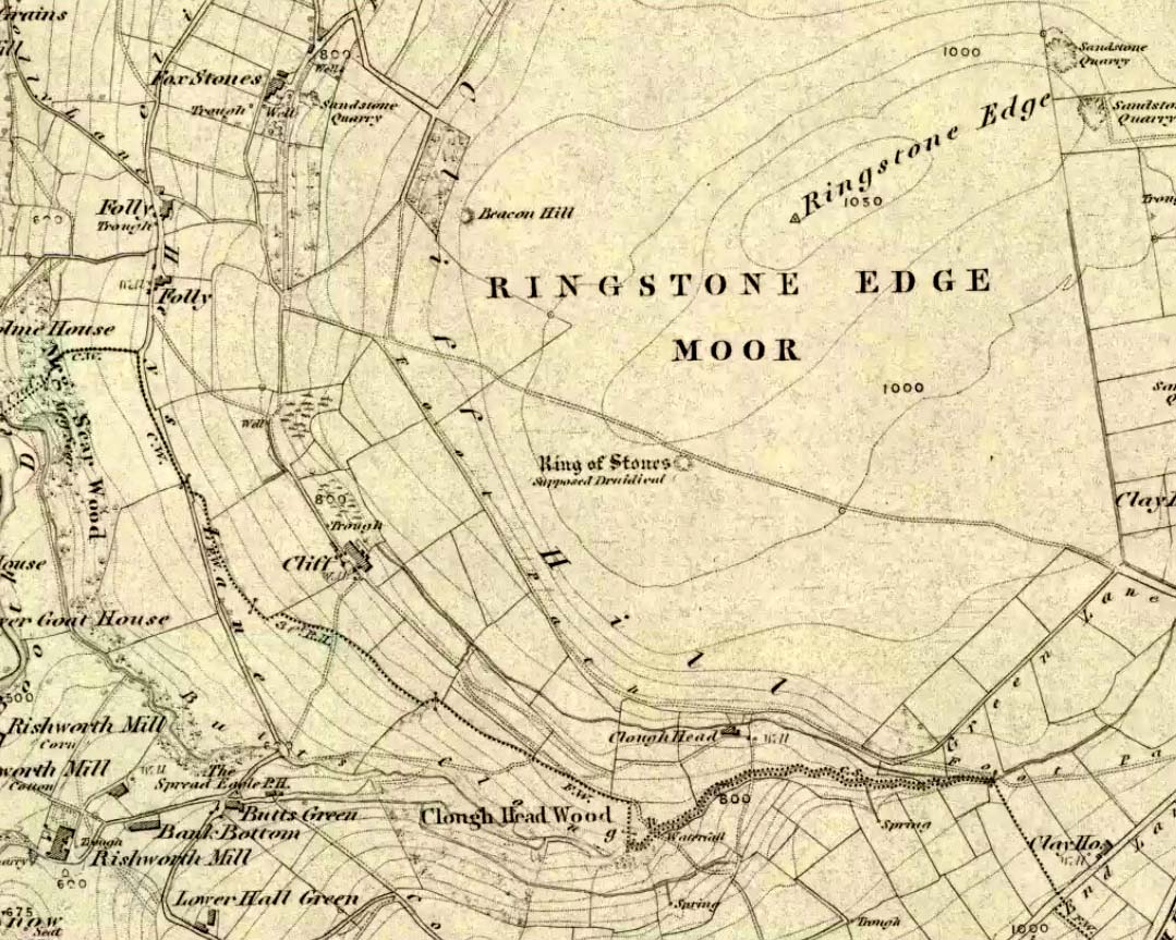
From Ripponden, taken the steep road up to Barkisland, but at the crossroads just before the village, turn right (south) and keep going for a mile till you reach the reservoir. At the far-end of the reservoir, take the track down by its side and follow the footpath that bends round the edge of the grasslands. Go up onto this small moorland and, once you’re on the level, head towards where you’ll see a large pile of stones a coupla hundred yards away. That’s it!
If we visit this site today, all we are left with is a scattered mass (or perhaps that should that be ‘mess’) of many hundreds of stones: the last remnants of what once would have been a proud circle of one form or another upon this small moorland plain. Its significance was such that the very moor on which its remains are scattered, was named after it: the Ringstone Edge Moor. But as with many sites from our megalithic period, this old place is but a shadow of its former self.
Gone are the upright monoliths which, tradition relates, once surrounded this low scattered circle of small loose stones (which would have made it look not unlike the wonderful stone circle of Temple Wood, Argyll). These standing stones were, so the folk record tells, removed near the end of the 18th century for use in some walling.
Described variously as a stone circle, ring cairn, cairn circle, an enclosure, and more, the site first seems to have been written about in 1775 by the great historian John Watson. When he was vicar of the local parish in Halifax (not far from here) this “ring of stones” as he called them, was “called the Wolf-fold.” Nearly one hundred years later, in F.A. Leyland’s superb commentary to Watson’s work, he wrote,
“The stones which constituted the circle at the time of their removal stood upwards of three feet…and the remain formed a striking object on the moor. The original number of stones of which the circle was formed is unknown, having long been in ruin and reduced in quantity before being finally removed. This was effected about twelve years since by the present tenant of the dam.” – that is, around 1859.
However, when Crabtree (1836) described the circle a decade or two earlier, he made no mention of such standing stones — although we must consider that Crabtree was very much like many modern academic archaeologists who tended to copy the works of others, much less than getting out in the field to see for himself.
At the beginning of the 20th century, the lore telling of the standing stones’ demise was repeated by local historian John Priestley (1903), when he said that: “all the large stones…were carted away about forty years ago” — that is, around 1863.
So it would seem that the very final destruction of the standing stones here, occurred sometime during the four year gap which Messrs. Leyland and Priestley describe.
More than fifty years later, Huddersfield historian James Petch (1924) came here to explore whatever remains he could find, and told:
“On top of a flat plateau on this moor, with an extensive view on all sides save on the north, where there is a gentle slope for some hundreds of yards up to the summit of the hill, there are distinct traces of a circular ring of small stones. Pygmie flints have been picked up within a yard or two, but the only other fact to be noted about this earthwork is that there is a tradition to the effect that much earth has been removed from this site. It is not altogether impossible that this is a scanty remnant of a round barrow.”
This latter remark of Mr Petch seems most probable. The excessive scatter of small stones typifies the remains of many of the Pennine giant cairns, from the Little Skirtful on Burley Moor and giant tombs of the Black Hills near Skipton, to the similar monuments of our Devil’s Apronful, Pendle, etc, etc.
Close to this cairn circle, wrote Sidney Jackson (1968), there used to be the remains of an Iron Age settlement, “marked by wall foundations (but) is now covered by the waters of Ringstone Reservoir.”
Folklore
There is very little folklore that I’ve found here. Watson (1775) throws the usual idea that the place was a site of druidical worship; but other than that we only have a local Ripponden writer’s account, which told that there was once the ghost of a white lady that was once said to walk along the path somewhere between here and the Beacon Hill tumulus, a short distance to the north.
Various ways to get here. From Worsthorne village, go east, up past the church, uphill following the dead straight path. After about 600 yards there’s a crossing in the footpath: go left here and walk another coupla hundred yards, over 2 walls, and after you’ve past the second wall you’ll notice the earthworks in the ground to your right. That’s it!
Archaeology & History
There’s nowt much to see here to be honest. It was included in Walter Bennett’s (1946) survey of ROMAN remains (oh dear) in the region — and his archaeological description of this place certainly seems to imply it was those doods (the Romans) who built this structure and not our neolithic ancestors. He wrote:
“Ringstones is a rectangular enclosure 50 yards square, surrounded by a mound or rampart 2 yards wide and one yard high, and an outer ditch two yards wide. Sepereated from the main enclosure by the ditch on the southeast side is another enclosure 18 yards square. Excavations made in 1925 gave the following information: a gateway, seven yards wide, was paved with boulder stones regularly laid on a gravel foundation, and on the south side of the gateway flat stones were sunk below the general floor level to act as a drain; a regular course of large stones flanked the gateway entrance on either side, and a foundation or irregular boulder stones was laid outside the gateway between the rampart and the ditch: inside the enclosure and 9 inches below the present grass surface., a floor had been made of gravel in some places and of flat stones or cobbles in others; the rampart was of earth and stones; a well-constructed road, 7 feet wide, ran from the earthwork in the direction of Bottin Farm, wich is situated on the Worsthorne-Roggerham road.”
There used to be a rough circle of stones on top of the site (probably giving the place its name), but these were apparently from the old remains of a lime-kiln from the 16th or 17th century — not prehistory. There is, therefore, a case that this site may not be prehistoric as archaeologists have classed it — and if the ground-plan above is anything to go by, you’d have to say it looks less than promising. More diggings are needed!
Easy to find if you go at the right time of year — very troublesome to find if you go at the wrong time! Check the place out at the end of winter, beginning of Spring. It’s at the top end of Shipley Glen, just past where the road bends round and goes uphill. About 50 yards up, on the left side of the road walk into the grasslands for less than 100 yards. Look around!
Archaeology & History
An intriguing site this one. Intriguing as it wasn’t in the archaeological registers when I first came across it — and I’m really unsure whether it’s in there now. It probably has, as John Barnatt came here with some earth-mystery folk in 1982! But when I first visited this site in 1975 it seemed no one knew about it — and little has changed since then.
It is an enclosed ring of stones less than 30 feet across with an earth embankment separating it from what seems like a secondary ring on its outer edge, a foot or two away. This didn’t appear to surround the complete ring and may have been damaged. It had an appearance similar in size, shape and form to the Roms Law and Harden Moor sites, and thankfully in reasonable condition. I don’t think any excavation has yet been performed here though.
There are a number of other small standing stones on the outskirts of this ring that may have some relationship with the site, but we need excavation to prove one way or the other. Several very well-preserved cup-marked stones are close by.
Folklore
Intriguing to those of you who are fascinated by alignments between sites, or ‘leys’, as an impressive lines runs through this site. Starting at the little known Hirst Woods Circle and terminating at the giant Great Skirtful of Stones cairn, once passing over the now destroyed Weecher circle and the Brackenhall Green ring on its way.
References:
Bennett, Paul, The Old Stones of Elmet, Capall Bann: Chieveley 2001.
Stone Circle (destroyed): OS Grid Reference – SO 303 976
Archaeology & History
Although geographically closer to the village of Priest Weston, this site — when still in existence — was in the parish of Churchstoke. To be found a half-mile west of White Grit (near the famous Mitchell’s Fold megalithic ring and standing very close to the local boundary line), the Welsh Royal Commision report (1911) told that its position was, “at the foot of the northern slope of Corndon Hill, and close to a stile on the south side of the road near the turning to Cliffdale Mine.” Found close to a number of other prehistoric remains, the Report told:
“It is certain that at this place there once stood a circle of eight or nine stones. An intelligent man, named John Jones, aged 74 years and a resident in the vicinity since his youth, remembers four stones arranged as though forming parts of a circle, with an appendage in a curve “like a hook.” About 100 yards distant was a cairn, the foundation of which is still discernible. The land was then unenclosed, but on its enclosure the cairn and the circle were rifled to provide stone for the construction of the existing fence. Mr Jones pointed out the four stones which had been members of the circle. The Rev. C. Hartshorne’s account of this circle in Salopia Antiqua, 1841, p.33, gives a slightly different account of the stones. He observes, “these three stones (the Whetstones) were formerly placed upright though they now lean, owing to the soft and boggy nature of the soil. The stand equidistant and assume a circcular position… The highest of these is four feet above the surface; 1 foot 6 inches in thickness; and 3 feet in width.”
When the Royal Commission lads got round to examining the remains here, they reported that,
“Only one stone is now to be found, embedded in the ground close to the stile entering the field, and this is so small that it is not likely to have formed one of the stones of the circle, or it must be a mere fragment of a larger mass.”
However, from the air, a very distinct circle is clearly visible, showing that something was here in bygone times. In all likelihood, there’s gonna be something just beneath the surface here to tell us more about whatever once stood here.
References:
Crawford, O.G.S., The Long Barrows of the Cotswolds, John Bellows: Gloucester 1925.
Royal Commission on Ancient & Historical Monuments, Wales, County of Montgomery, HMSO: London 1911.


")
")