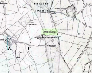
Hillfort / Settlement: OS Grid Reference – SE 435 104
From the South Kirkby library, go west along Hague Lane and take the left turn up Homsley Lane on your left after a few hundred yards (keep your eyes peeled!). Go up here, past the housing estate, and where the trees begin on your left at the top of the Hilltop Estate, go thru them and as you emerge out the other side, the earthworks are all around you. In fact you’re just about in the middle of this hillfort-cum-settlement!
Archaeology & History
W.S. Banks (1871) gives an early description of this site, although he thought it to be Saxon in nature. He told that,
“About half-a-mile east of Ringston Hill, in a field between Quarry-road and Hornsley-road, is the site of a supposed Saxon camp, as it is called on the ordnance map — a large enclosure containing above three acres of land. It slopes to the north, and is now rough and uneven, and has been cast into ‘lands.’ The mound on the east, west and south is still very distinct. The northern side is much lower than the other and a ditch is cut across at that part…”
And in Banks’ day, as he told, “the history of it is not known.” But this site was later declared as a hillfort – a Brigantian one at that – for the first time by the director of Wakefield Museum, Mr F. Atkinson, following some excavation work here in 1949. Nothing much was found apart from,
“pieces of decayed and burnt sandstone and medieval pottery sherds,” though he still concluded the site to be Iron Age. Although little of its original form can now be seen due to extensive damage, infra-red aerial photography showed “traces of a five-sided annexe to the northwest, the line of the ploughed-out rampart to the south-southwest, and a possible defended entrance to the south.”
The same aerial survey also found another enclosure to the east of the hillfort.
…to be continued…
References:
- Banks, W.S., Walks in Yorkshire: Wakefield and its Neighbourhood, Longmans Green & Co.: London 1871.
- Keighley, J.J., ‘The Prehistoric Period,’ in Faull & Moorhouse’s, West Yorkshire: An Archaeological Survey, I, WYMCC: 1981.
© Paul Bennett, The Northern Antiquarian
The map could not be loaded. Please contact the site owner.
