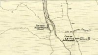
Langside House, Cathcart, Glasgow, Lanarkshire

Cup-and-Ring Stone (removed):  OS Grid Reference – NS 5726 6128

Also Known as:

  1. Bluebell Woods
  2. Canmore ID 44291
  3. Langside Stone

Archaeology & History

Langside House carving

Amidst where now the busy city spreads on the south-side of Glasgow, there was once an excellent multi-ringed prehistoric petroglyph to be seen.  According to the official records, it was all alone – but I don’t buy that for one minute! (petroglyphs rarely occur in isolation)  However, it looks as if this might have been the last of its kind in the area, betwixt where now large houses grow in the landscape of Langside and Battlefield, a few hundred yards south of the hillfort-topped Queen’s Park.

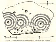
Before being noticed by archaeologists, the stone was apparently being used as a stone seat in the woods for people to sit on!  It was probably a part of a larger monument, perhaps a cairn of some sort.  Certainly from the sketches we have of it, it was part of a larger piece of stone and was likely to have had companions, but records seem to be silent on the matter. The most detailed description of it comes from the pen of northern antiquarian Fred Coles (1906), who gave us the following literary portrait:

“The first notice of the Stone incised with the design shown below was due to Mr W. A. Donnelly, who contributed a description and a sketch to The Glasgow Evening Times of 25th June 1902.  Later, Mr Ludovic Mann, at my request, sent me certain notes he had taken of the cup-and-ring-marks.  But prior to this, the Stone itself had, on the instigation of Mr Donnelly, I think, been removed from its site in the wood, and placed near one of the entrances to the new Kelvinside Museum.  There I saw it and made measurements in July 1903.

“The Bluebell Wood lies in a curving line to the west and south of Langside House, and the cup-marked Stone was at a point in the southern extremity of the wood, above and north of the river Cart.  It is interesting to be able also to record that the longer axis of the Stone lay almost precisely north and South, and the opposite axis east and west.*  The Stone is of a hard, whitish sandstone, a good deal weathered and rounded at the edges. It measures 4 feet 9 inches in length and 3 feet 2 inches in breadth, and varies in thickness from 2 feet 6 inches to 1 foot 7 inches.  The striation of the Stone has helped to efface the cuttings which, though perfectly clear and measurable, are shallow in proportion to their width.  And this feature I have endeavoured to portray in the accompanying illustration (above).  Beginning at the north end of the Stone, there is one cup placed just where the outermost ring of that group touches the edge of the Stone.  The ring has a groove leading towards but not into a central cup, and four other cups are placed on the two outermost rings, there being four rings in this group.  The middle group consists of a central cup and three rings, flanked on the west by a row of three cups (one of which is the largest of all), and on the east by a double row of six cups, three of which are almost obliterated.  This middle group is imperfectly concentric, two of its arcs running into the fourth ring of the group on the south, which has a fine deeply picked central cup.  All the better-preserved rings are very nearly 1½ inches in width of cutting.

“The diameters of the outermost rings in each group are: of the north group, 1 foot 9 inches; of the middle group 1 foot 5 inches; and of the south group 1 foot 7 inches.  The cups vary in diameter from 3 inches to 1½.

“Considering the extremely easily weathered nature of this Stone, and the fact that its sculptured surface has already suffered much ill-usage, its present position, near the entrance of the Art Galleries, entirely unprotected by a railing and exposed to all sorts of abuse by casual passers-by as well as the weather, is not a fit and proper place for a Stone of such interest.”

A few years after this, the local historian Ludovic MacLellan Mann (1930) wrote a piece for the Glasgow Herald, in which he thought that both this and another carving in the area,

“commemorate chiefly…an eclipse of the sun seen in Glasgow district in the year 2983 BC, at three o’ clock in the afternoon of the sixth day after the Spring Equinox.”
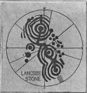
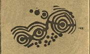
Mann’s 1930 sketch

A fascinating idea…  Mann was intrigued by the theory that petroglyphs represented astronomical events or maps of the skies – and we know from cultures elsewhere in the world that some carvings had such a function; but it’s not integral to all carvings by any means.

The stone was included in Ron Morris’ (1981) survey, merely echoing the description of Fred Coles, adding nothing more.  And so it seems that the carving is still in the museum somewhere.  Canmore has it listed as “Accession no: 02-78”.  Does anyone know of its present situation?  Can anyone get a photo so we can give it a more fitting site profile?  It looked a damn good carving!  And, if anyone lives nearby, I note that there are small patches of the old woodland still visible on GoogleEarth: therein, perhaps, a diligent explorer may just find another carving….

References:

  1. Coles, Fred, “Notices of Standing Stones, Cists and Hitherto Unrecorded Cup-and-Ring Marks in Various Localities,” in Proceedings of the Society of Antiquaries, Scotland, volume 40, Edinburgh 1906.
  2. Donnelly, W.A., “Letter”, Glasgow Evening Times, 25 June, 1902.
  3. Mann, Ludovic MacLellan, “The Eclipse in 2983 B.C. – Discovery near Glasgow,” in Glasgow Herald, 17.09.1930.
  4. Morris, Ronald W.B., “The Cup-and-Ring Marks and Similar Sculptures of South-West Scotland,” in Transactions of the Ancient Monuments Society, volume 14, 1967.
  5. Morris, Ronald W.B., The Prehistoric Rock Art of Southern Scotland, BAR: Oxford 1981.
  6. Morris, Ronald W.B. & Bailey, Douglas C., “The Cup-and-Ring Marks and Similar Sculptures of Southwestern Scotland: A Survey,” in Proceedings of the Society of Antiquaries, Scotland, volume 98, 1966.
  7. Small, Sam, Greater Glasgow: An Illustrated Architectural Guide, RIAS: Edinburgh 2008.

ACKNOWLEDGEMENTS:  Huge thanks to beautiful Aisha for putting me up.

* Although Coles did note how its earlier use as a stone seat probably negates his axial measurements.

© Paul BennettThe Northern Antiquarian


Lady Well, Glasgow, Lanarkshire

Holy Well:  OS Grid Reference – NS 60376 65323

Also Known as:

  1. Canmore ID 45037

Getting Here

Lady Well on 1865 OS-map

Lady Well on 1865 OS-map

Get yourself to Glasgow Cathedral—wherein you’ll find St. Mungo’s Well—and walk down John Know Street.  A coupla hundred yards down, across the road is a small street called Ladywell Lane (there’s no signpost for it though), running below the cemetery and leading to the back entrance of the giant Tennent’s Brewery.  At the bottom of this, up against the wall on your left, is the Lady Well.

Archaeology & History

The origins and early traditional history of this once famous sacred well are sadly lost due to the intrusion of industrialism.  It was obviously a place of some considerable repute and lent its name to local quarries and fields hereby.  Used extensively by local people for countless centuries, things were to change in 1715 when the waters of this and other wells were to be kept clean by one John Black, “at a salary of 400 merks yearly.”  The Glasgow historian Eyre-Todd (1934) told that,

“Black was to furnish them with chains, buckets, sheaves, ladles, and other necessary graith, aswell as with locks and iron bands.  He was ‘to cleanse, muck and keep them clean,’ and to lock and open them in due time, evening and morning.  In case of failure he was liable to a penalty of £100 Scots.”

Lady Well in 2015

Lady Well in 2015

Lady Well in 1883

Lady Well in 1883

That’s a helluva lot of money in those days!  Even when M’Ure (1736) described it, only in passing, he had nothing to say about its curative properties or local rites.  Once the Industrialists take control, the ways of local people are sanitized, sterilized and ‘progress’ outlaws tradition.  The only reference to an earlier sacrality is in Mr Russel’s (1883) article, where he said simply, that the Lady Well was “so called after a fountain at the bottom of the Craigs…sacred in Popish times to the Virgin.”

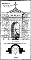
The construction that we see today—of the well in its little enclave—was first built in 1835-6.  The waters became polluted after they were redirected below the Necropolis and have not been used since (although they still flow out of the wall a couple of yards to the right, stinking!).  The architectural feature was cleaned up and restored by the local brewery in 1983.

The site may have gained its name from one Lady Lochow, who lived nearby and built a hospital at the old Gorbels in the 14th century—but we might never know the real truth about the origin of its dedication.  However, an intriguing ingredient relating to the dedication of the Lady Well is the incidence of a St. Anne’s Street that used to exist immediately to the east, as seen on the 1865 OS-map above.  St. Anne may well be the mythic character behind the naming of this Lady Well, although I can find no literature to prove this.  In the christian mythos, St. Anne was a very important character indeed: the mother of the Virgin Mary no less!  However, as hagiographers from Attwater (1965), to Baring-Gould (1898) and Butler (1866) all tell, her biography is piecemeal—which is most surprising considering she was JC’s granny!  Anne’s festival date was July 26 (a couple of days after Sirius enters the northern hemisphere); she was the patron saint of midwives, grandmothers and also miners, who invoked her as the deity who produced gold and silverakin to the Earth Mother Herself!  It’s obvious that Anne’s original mythic nature was subdued, as she represented an archaic root of matriarchal triplicity of the Virgin, the Lady and Old Woman and not the patriarchal triplicity of the incoming christian cult.  The christian mythos at this Lady Well (as elsewhere) replaced one facet of the indigenous prima mater in Glasgow, known as the Cailleach—as shown in her attributes of midwife, grandmother and the deep Earth.  If local historians can find field-names or wells dedicated to the Maiden, the Lady and the Carlin (or their variant titles) nearby, the lost layers of archaic Glasgow’s indigenous animistic folk memories could be mapped out once again…

References:

  1. Attwater, Donald, The Penguin Dictionary of Saints, Penguin: Harmondsworth 1965.
  2. Baring-Gould, S., The Lives of the Saints – volume 8, J.C. Nimmo: London 1898.
  3. Bennett, Paul, Ancient and Holy Wells of Glasgow, TNA 2017.
  4. Brotchie, T.C.F., “Holy Wells in and Around Glasgow,” in Old Glasgow Club Transactions, volume 4, 1920.
  5. Butler, Alba, The Lives of the Fathers, Martyrs and other Principal Saints – volume 7, James Duffy: Dublin 1866.
  6. Eyre-Todd, George, History of Glasgow – volume 3, Jackson: Glasgow 1934.
  7. Greene, E.A., Saints and their Symbols, Sampson Low: London 1897.
  8. MacIntosh, Hugh, The Origin and History of Glasgow Streets, James Hedderwick: Glasgow 1902.
  9. M’Ure, John, History of Glasgow, D. MacVean: Glasgow 1736.
  10. Walker, J. Russel, “‘Holy Wells’ in Scotland,” in Proceedings of the Society of Antiquaries of Scotland, vol.17 (New Series, volume 5), 1883.

© Paul BennettThe Northern Antiquarian


Braidwood, Carluke, Lanarkshire

Standing Stone (destroyed):  OS Grid Reference – NS 8435 4799

Also Known as:

  1. Canmore ID 46543

Archaeology & History

1864 OS-map, showing the stone

1864 OS-map, showing the stone

Illustrated on the 1864 Ordnance Survey map, right by the roadside a hundred yards or so east of Braidwood House, once stood a proud standing stone – but sadly there are no remains of the monument today.  It was said by Mr Groom (1882), in his encyclopaedic Gazetteer of Scotland, that the stone was “supposed to have been a milestone on Watling Street,” but we have no way of verifying this with any certainty.  However, a similar association was conferred upon the stone by local people when the site was visited by the reverend John Wylie in 1839, when it was still standing.  Writing in the Statistical Account of Carluke, Wylie told,

“It is supposed to have stood at the side of a Roman Road, passing from Lanark, across the bridge of the Mouse beneath Cartland Crags, through Lee Valley, across Fiddler’s Burn at Chapel, and thence by Braidwood into the main street.”

The last record we have of the stone still being in position is from the 1898 OS-map, but sometime thereafter it was uprooted and destroyed.  Any further information about the stone would be gratefully welcomed.

References:

  1. Groom, Francis H. (ed.), Ordnance Gazetteer of Scotland – volume 1, Thomas C. Jack: Edinburgh 1882. 
  2. Royal Commission on the Ancient & Historic Monuments of Scotland, Lanarkshire: An Inventory of the Prehistoric and Roman Monuments, HMSO: Edinburgh 1978.

© Paul BennettThe Northern Antiquarian


High Banks (03), Kirkcudbright, Kirkcudbrightshire

Cup-and-Ring Stone (lost):  OS Grid Reference – NX 709 489

Archaeology & History

One of the lost High Banks carvings

One of the lost High Banks carvings

The drawing here is another by the legendary Fred Coles, previously unpublished until Maarten van Hoek (1990) brought it out of the dusty archives of the Stewartry Museum, Kirkcudbright, and described it in his article on prehistoric rosette motifs.  As with its fellow carving of High Banks 2, the location of the site remains unknown; and van Hoek wondered whether these two lost carvings “could have been located at the spot where now the little quarry at High Banks site is found.”  Let’s hope not!

References:

  1. Morris, Ronald W.B., The Prehistoric Rock Art of Galloway and the Isle of Man, Blandford: Poole 1979.
  2. van Hoek, M.A.M., “The Rosette in British and Irish Rock Art,” in Glasgow Archaeological Journal, volume 16, 1990.

© Paul BennettThe Northern Antiquarian


High Banks (02), Kirkcudbright, Kirkcudbrightshire

Cup-and-Ring Stone (lost):  OS Grid Reference – NX 709 489

Archaeology & History

One of the lost High Banks carvings

One of the lost High Banks carvings

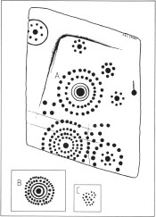
This impressive carving was found somewhere in the vicinity of the well-known High Banks (01) cup-and-ring menagerie, with its clustered mass of cups and multiple rings.  And the carving we see here possesses something of a similarity with its complex neighbour—but it remains lost.

The drawing was done by our old Scottish megalithomaniac Fred Coles, who discovered the carving when he visited the area around the beginning of the 20th century.  It remained unpublished until fellow rock art student Maarten van Hoek (1990) explored the region and found it hiding away in the archives at the Stewartry Museum, Kirkcudbright.  The multiple rings of cups surrounding central cups and cup-and-rings are very rare things indeed and this carving is utterly unique in the British Isles.

In Coles’ drawing, as well as the large carving, we have two other elements below, boxed.  These are taken from a notebook found in the same Stewartry Museum and thought to have been done by a Mr G. Hamilton around 1866.  In the lower-box, the double-ringed cup with its surround of two more rings of cup-marks was suggested at first by van Hoek (1990) to possibly be the same carving as that found by Coles.  But he questioned this, sensibly, as the carved design ‘B’,

“comprises 35 cups (its diameter stated to be 21 inches / 51cm), whereas Coles’ diagram of ‘A’ shows only 24 outer cups.  The unknown artist moreover says that, ‘The above (B) is one of a splendid group on Banks Farm.’  So this rosette (B) might be a completely different specimen altogether.”

I have to agree with him.  In the second smaller box, ‘C’, the drawing of the cluster of cup-marks is taken from the same 19th century notebook in which the author said there was a cluster of

“70 to 100 small cups without any apparent system, except being in a group of 7 with cup in the centre—also 3 or 4 circles.”

No other details were given.  Petroglyph explorers in the area should keep their senses peeled when meandering about here, for this and other missing carvings (High Banks 3).

References:

  1. Morris, Ronald W.B., The Prehistoric Rock Art of Galloway and the Isle of Man, Blandford: Poole 1979.
  2. van Hoek, M.A.M., “The Rosette in British and Irish Rock Art,” in Glasgow Archaeological Journal, volume 16, 1990.

© Paul BennettThe Northern Antiquarian


Firbhreige, North Uist, Outer Hebrides

Standing Stones:  OS Grid Reference – NF 7700 7031

Also known as:

  1. Canmore ID 10079
  2. Toroghas

Getting Here

This is nice n’ far north indeed – north-west Uist in fact!  Hit the A865 road northwest to the village of Ceann a’ Bhaigh.  By the little church at the little crossroad, take the track on your right which leads you into the hills.  Go all the way to the end of this track and walk straight north for a couple of hundred yards, as if you’re heading up the hill, Toroghas, in front of you.

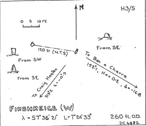
Thom’s drawing of the Stones & possible alignments


Archaeology & History

Here are two small standing stones, each not much more than three-feet tall, about 40 yards apart.  Alexander Thom (1984) looked for astronomical alignments here, but found very little, merely commenting:  “From here a number of sites are visible, but the (easternmost) stone might be said to indicate Craig Hasten or Deaskeir Islet.”  In his own analysis of the site, Clive Ruggles (UI23 – 1984) also found such astronomy lacking here.

Folklore

In Thom, Thom & Burl’s (1990) description of these two small stones, Aubrey Burl mentioned how “their name is similar to the stones on Skye called ‘Na Fir Bhreige’, or ‘the false men’. This has been variously interpreted as meaning men who were turned to stone for being unfaithful to their wives or, alternatively, to stones that from a distance resembled men.”  Which is apparently the tale here. (see Grinsell 1976)

Comparative religious studies clearly indicate that legends of petrified beings are representative of the spirits of the ancestors residing in the said stones or other artifact.  If there’s any validity to this ingredient, it would imply that some prehistoric burials can be found nearby — though my archaeo-records show nothing (but that doesn’t mean they’re not there).  If there anyone goes wandering hereabouts in the near future, see if you can find any tombs in the locale.

References:

  1. Beveridge, Erskine, North Uist: Archaeology and Topography, William Brown: Edinburgh 1911.
  2. Ruggle, C.L.N., Megalithic Astronomy, BAR: Oxford 1984.
  3. Thom, A., Thom, A.S. & Burl, A., Stone Rows and Standing Stones, vol.1, BAR: Oxford 1990.

© Paul BennettThe Northern Antiquarian


Carra Bhroin, Lochboisdale, South Uist

Standing Stone:  OS Grid Reference – NF 8117 2248

Also Known as:

  1. Canmore ID 10138
  2. Carragh broin

Archaeology & History

The nature of this site seems a little disputed.  Shown on modern OS-maps and cited as being visited and seen in April 1967, the Canmore website also describes it in the present tense — but when I.A. Crawford (1965) wrote of this site he told that, “this standing stone…has been destroyed in fencing operations” — i.e., building a fence or wall, not some doods having a fencing fight!

Equally curious would be the stature of the site; as in the Royal Commission report (1928), the stone was told to be only 2-feet tall — which would mean that if this site is included as an authentic archaeological site, then we’re gonna have to double or treble the number of standing stone sites nationally!  There are masses of ‘monoliths’ two-feet tall and above which are in the ‘natural’ category.  But this stone, for whatever reason (the folklore probably), has been granted the providence as an authentic standing stone.

Folklore

Tradition told that this old stone was “alleged to mark a battle site” in ancient days.  The variation on this theme tells that the stone marked the grave of a man who was slewn in battle here.  Seems likely that there will be prehistoric tombs nearby…

References:

  1. Crawford, I.A., ‘Carra Bhroin, S.Uist,’ in Discovery & Excavation in Scotland, 1965, SRG & CBA 1965.
  2. Royal Commission on the Ancient & Historical Monuments & Constructions of Scotland, Inventory of Monuments and Constructions in the Outer Hebrides, Skye and the Small Isles, HMSO: Edinburgh 1928.

© Paul BennettThe Northern Antiquarian


Weeping Stone, Fladaigh Chuain, Skye

Legendary Rock: OS Grid Reference – NG 3638 8091

Getting Here

Unless you’ve got your own boat, forget it!  This one’s miles out on the isolated uninhabited island of Fladda-chuain about 5 miles off the northwest tip from Duntulm, Trotternish.  I wouldn’t mind a coupla weeks alone on the isle though – if anyone can get me there!

Archaeology & History

This little rocky island was allegedly another one of the many visiting places that St. Columba frequented in his copious ventures, trying to sell his new religion to local people wherever he went.  Here he came to the legendary clach known as the Weeping Stone: a place of reverence to the druids and indigenous people.  But St Columba came here to christianize the rituals that were had at the site; and, eventually, he was allowed to build a  small stone chapel close by.

Folklore

In Otta Swire’s (1961) excellent work on the folklore and history of the Isle of Skye, she wrote:

“In Duntulm Bay lies Tulm Island and beyond it, in clear weather, Fladdachuan, Fladda of the Ocean, can be seen. In olden times this was a sacred spot, held by many to be Tir-nan-Og, the Isle of Perpetual Youth, which lay in the west; here it is always summer and the sun never sets. The puffins recognized its sacred nature and never began any venture until they had circled the island three times sunwise; this they did also on arriving in Skye and before leaving it. It was held by some to be the reason why in Skye people used to turn three times sunwise before starting a new enterprise. The Druids held it in veneration and St. Columba caused a chapel to be built there. On its altar lay a black stone which some say was the original altar stone of the Druids and which was known as the Weeping Stone because it was always wet. Until fairly recently fishermen used to land on the island and pour three handfuls of seawater on the stone to procure favourable winds or to stop bad floods. The Weeping Stone no longer exists, or at least is no longer to be found where the altar once stood.”

I can’t find anything more about this place.  Does anyone know owt more about it?

References:

  1. Swire, Otta F., Skye: The Island and its Legends, Blackie & Son: Glasgow 1961.

© Paul BennettThe Northern Antiquarian


Temple of Anaitis, Lusta, Waternish, Skye

‘Stone Circle’: OS Grid Reference – NG 2725 5273

Also Known as:

  1. Annait
  2. Temple of Annait

Getting Here

1880 map of Anaitis

1880 map of Anaitis

Otta Swire (1961) told how to find this place, thus: “The Waternish road turns off to the north at Fairy Bridge, whence it runs along the valley of the Bay river. On the left of the road, though at some little distance from it, where the river cleaves its way through a gorge to the sea, stands the mound which is now all that remains of the ‘Temple of Anaitis’ (so called).”

Archaeology & History

This is a curious place, full of archaeological potential if the folklore and history records are owt to go by, yet little of any substance remains to substantiate what may have been an important stone circle or other heathen site in earlier times. It seems to have been described first of all in the famous Hebridean journeys of Boswell and Johnson in the late 18th century.  Amidst his insulting description of both the landscape and local people, on Friday 17th September 1773, James Boswell visited the site and told:

“The weather this day was rather better than any that we had since we came to Dunvegan. Mr M’Queen had often mentioned a curious piece of antiquity near this which he called a temple of the goddess Anaitis.  Having often talked of going to see it, he and I set out after breakfast, attended by his servant, a fellow quite like a savage.  I must observe here, that in Skye there seems to be much idleness; for men and boys follow you, as colts follow passengers upon a road. The usual figure of a Sky boy, is a lown with bare legs and feet, a dirty kilt, ragged coat and waistcoat, a bare head, and a stick in his hand, which, I suppose, is partly to help the lazy rogue to walk, partly to serve as a kind of a defensive weapon. We walked what is called two miles, but is probably four, from the castle, till we came to the sacred place. The country around is a black dreary moor on all sides, except to the sea-coast, towards which there is a view through a valley, and the farm of Bay shews some good land. The place itself is green ground, being well drained, by means of a deep glen on each side, in both of which there runs a rivulet with a good quantity of water, forming several cascades, which make a considerable appearance and sound.  The first thing we came to was an earthen mound, or dyke, extending from the one precipice to the other.  A little farther on, was a strong stone-wall, not high, but very thick, extending in the same manner.  On the outside of it were the ruins of two houses, one on each side of the entry or gate to it. The wall is built all along of uncemented stones, but of so large a size as to make a very firm and durable rampart. It has been built all about the consecrated ground, except where the precipice is deep enough to form an enclosure of itself. The sacred spot contains more than two acres. There are within it the ruins of many houses, none of them large, a cairn, and many graves marked by clusters of stones. Mr M’Queen insisted that the ruin of a small building, standing east and west, was actually the temple of the goddess Anaitis, where her statue was kept, and from whence processions were made to wash it in one of the brooks. There is, it must be owned, a hollow road visible for a good way from the entrance; but Mr M’Queen, with the keen eye of an antiquary, traced it much farther than I could perceive it. There is not above a foot and a half in height of the walls now remaining; and the whole extent of the building was never, I imagine, greater than an ordinary Highland house. Mr M’Queen has collected a great deal of learning on the subject of the temple of Anaitis; and I had endeavoured, in my journal, to state such particulars as might give some idea of it, and of the surrounding scenery” —

But in all honesty it seems Mr Johnson was either too lazy to write about the place, or simply didn’t actually get there, in spite of what he alleged!  But later that evening, Boswell dined with the same Mr MacQueen, who told him more of this site.  In the typically pedantic tone of english supremacy (which still prevails in some idiots who visit these lands), he continued by saying:

“Mr Macqueen had laid stress on the name given to the place by the country people, Ainnit; and added, ” I knew not what to make of this piece of antiquity, till I met with the Anaitidis delubrum in Lydia, mentioned by Pausanias and the elder Pliny.”  Dr. Johnson, with his usual acuteness, examined Mr Macqueen as to the meaning of the word Ainnit, in Erse, and it proved to be a water-place, or a place near water, “which,” said Mr. Macqueen, “agrees with all the descriptions of the temples of that goddess, which were situated near rivers, that there might be water to wash the statue.”

There ensued a discussion between Mr MacQueen and Samuel Johnson about the etymology of ‘Anaitis’, with one thinking it was of a goddess, and another that it represented an early christian site.  To this day it is difficult to say what the word means with any certainty.  In W.J. Watson’s (1993) fine work he tells us,

Andoit, now annaid, has been already explained as a patron saint’s church, or a church that contains the relics of the founder.  This is the meaning in Ireland and it is all we have to go upon.  How far it is held with regard to Scotland is hard to say… They are often in places  that are now, and must always have been, rather remote and out of the way.  It is very rarely indeed that an Annat can be associated with any particular saint, nor have I met any traditions connected with them.  But wherever there is an Annat there are traces of an ancient chapel or cemetery, or both; very often, too, the Annat adjoins a fine well or stream…”

The great Skye historian and folklorist Otta Swire (1961) also wrote about this mysterious site, mainly echoing what’s said above, but also adding:

“This name of Annait or Annat is found all over Scotland. It has been interpreted as meaning the ‘Water-place’ from Celtic ‘An’ = water, because many are near water. Others suggest ‘Ann’ = a circle (Celtic) and claim that most Annats are near standing stones. The most-favoured derivation seems to be from Ann, the Irish mother of the Gods, and those who hold this view claim that the Annats are always near a revered spot, where either a mother-church or the cell of a patron saint once stood. Probably Annat does, in fact, come from an older, pre-Celtic tongue, and belongs to an older people whose ancient worship it may well commemorate. The curious shape of the Waternish Temple of Anaitis and its survival make it seem likely that it was something of importance in its day, built with more than usual care and skill. Perhaps the Temple tradition is correct – but whose, if so, and to what gods? One cannot help wondering if cats played any part in its ritual, and if so, if any faint memory remains, for the nickname of the people of this wing was ‘Na Caits’ = The Cats, and not far off, by one of the tributary burns on the right of the roadway, there stands a small cairn, crowned by a long, sharp stone somewhat resembling a huge claw. This is the ‘Cats’ Cairn’.”

The Cats’ Cairn (NG271526) is said to mark the grave of a young boy from the 18th century, who was buried where he died and its story is told elsewhere on TNA.  Another example of the Annait place-name can be found elsewhere on Skye at the megalithic site, Clach na h’annait.

References:

  1. Boswell, James, The Journal of a Tour to the Hebrides with Samuel Johnson, National Illustrated Library: London 1899.
  2. Swire, Otta F., Skye: The Island and its Legends, Blackie: Glasgow 1961.
  3. Watson, W.J., The History of the Celtic Place-Names of Scotland, Birlinn: Edinburgh 1993.

© Paul BennettThe Northern Antiquarian


Raven’s Stone, Elgol, Strathaird, Skye

Standing Stone (destroyed):  OS Grid Reference – NG 520 144

Folklore

This once-famous standing stone appears to have gone.  It was described in Otta Swire’s (1961) superb book on the folklore of Skye, where she wrote:

“Overlooking Elgol is Bidein an Fhithich. Near here once stood the famous Raven’s Stone, about which the Brahn Seer prophesied. It is believed that this prophecy, however, can never be fulfilled, as seventy or eighty years ago the stone was broken up and the main portion of it is now incorporated in one wall of the Glendale church, according to the Rev. A. R. Forbes’ Place Names of Skye. The stone was believed to have had some connexion with old pagan religious ceremonies.”

The Brahn Seer (more commonly known as the Brahan Seer) was Coinneach Odhar, a 16th century prophet who is said to have foretold the Battle of Culloden and other events.

References:

  1. Swire, Otta F., Skye: The Island and its Legends, Blackie & Sons: Glasgow 1961.

© Paul BennettThe Northern Antiquarian