Delf Well, Edinburgh, Midlothian

Healing Well:  OS Grid Reference – NT 28220 72715

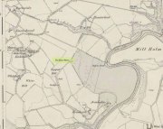
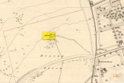
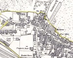
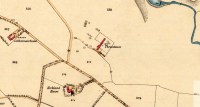
Delf Well on 1852 map

Getting Here

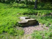
From the south-side of Arthur’s Seat at Duddingston, along Duddingston Road West, turn west along Old Church Lane.  Where the houses finish there’s the loch on your left and the small car-park on your right.  From here, walk above the cars and onto the small footpath.  Barely 20 yards ahead, under the edges of the trees, a sealed oblong concrete water-hole is front of you.  That’s the spot you’re looking for.

Archaeology & History

Delf Well, covered

Only for the purists amongst you, the Delf Well has fallen prey to being capped and piped away so you can no longer drink here.  It is shown on the early 19th century maps of the area and was used as a water supply for the opulent South Lodge of Holyrood Park.  An old metal chain — remains of which are still attached to the covering stone — once had an old cup attached, to enable walkers to drink here.

References:

    1. Bennett, Paul, Ancient and Holy Wells of Edinburgh, TNA: Alva 2017.
    2. Harris, Stuart, The Place-Names of Edinburgh, Gordon Wright: Edinburgh 1996.

Paul BennettThe Northern Antiquarian


Crawley Spring, Glencorse, Midlothian

Healing Well (covered):  OS Grid-Reference – NT 23894 63346

Archaeology & History

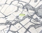
Site of Crawley Spring on 1854 map

Site of Crawley Spring on the 1854 map

Once found flowing freely beneath the shadow of the prehistoric hillfort of Castlelaw, this all-but-forgotten site was thankfully recorded in Hope & Telford’s (1813) survey of Edinburgh’s natural water supply.  Mr Telford said how “This noble spring rises from the bottom of a bank, at the foot of the Castlelaw Hill, at the edge of a small, low, almost marshy meadow close by the Glencorse Burn, a little way below the bridge.”  Twelve years after writing this, the well had been blocked and a cistern built over it.

It was proclaimed by local people to be medicinal (though to what ailments, I cannot find), but there was an effective confirmation of some medicinal qualities in the waters following an analysis in 1810 when very tiny mineral elements were found.  Mr Telford (1813) explained:

“The water is perfectly transparent and colourless, free from every smell and taste and is of excellent quality.  It has, as is the case with almost all spring water, some matters dissolved in it, though in smaller quantities than common… This foreign matter consist of carbonate of lime, muriate of soda, and sulphate of lime, with an excessively minute portion of magnesium salt. The proportions of these ingredients, in each pound, are nearly:

Carbonate of Lime – 0.43 of a grain
Muriate of Soda – 0.10 of a grain
Sulphate of Lime – 0.90 of a grain
Sulphate of Magnesia – 0.05 of a grain

The carbonate of lime is dissolved by means of carbonic acid, which is not in greater quantity than is barely sufficient for the purpose.  All of these ingredients are in themselves innocent to the human body; and in the quantity in which they are present in the water, do not affect its goodness.  The water is perfectly soft and fit for washing, infusing tea and other domestic purposes.  The water, therefore, is exceptional in every respect.”

When it came to the Crawley Spring waters being used to feed the habits of Edinburgh city, there was considerable opposition by the land-owner and local people who were, correctly, concerned that that ecosystem here would be adversely affected if the waters were to disappear.  And so it was that Earth’s blood was taken from the land and the people and the animals, to benefit and feed the religion of Industrialism and ‘progress’ once more…

References:

  1. Bennett, Paul, Ancient and Holy Wells of Edinburgh, TNA: Alva 2017.
  2. Hope, Thomas C. & Telford, Thomas, Reports on the Means of Improving the Supply of Water for the City of Edinburgh, A. Constable: Edinburgh

© Paul BennettThe Northern Antiquarian


Bell Stane, Queensferry, Midlothian

Legendary Stone (destroyed):  OS Grid Reference – NT 1292 7840

Bell Stane on 1896 map

Bell Stane on 1896 map

Archaeology & History

An intriguing site that needs adding to the Northern Antiquarian due to the foraging research of the Edinburgh historian Stuart Harris (1996).  Although the Bell Stane has been ascribed by the Canmore researchers to be just,

“a stone near the Mercat Cross on which the hand bell was set (rung to herald the opening of the weekly market or annual fair),”

Mr Harris dug deeper and found other references which led him to think that the site was “a conspicuous boulder or standing stone.”  I have to agree with him.  In his outstanding work on the historical place-names of Edinburgh and district, Harris wrote:

“The Bellstane…is noted on Ordnance Survey 1854 as the name of an object just outwith the burgh boundary and in the southwest corner of the little square that now bears the name.  Whilst it has been surmised that it was a stone named for a handbell rung beside it on market days, in point of fact a burgh council meeting of 1642 (quoted in Morison’s Queensferry, p.131) records that a piece of ground hitherto waste and unused, within the burgh but near the bellstane, was to be set aside for markets and fairs in times coming; and the clear inference is that the name belonged to the stone before any markets were held near it.  In absence of a reliable description of the stone or of early forms of its name, the origin of the name can only be guessed at.  Similar names (of sites) in Kirknewton and Whitburn are no better documented, but the early forms of Belstane in Lanarkshire (BellitstaneBellistaneBelstane and Bellstane prior to 1329 and Beldstanein 1452) suggest that its first part may be Anglian ballede or early Scots bellit (from a Celtic root, ball, white), making the name ‘the stone with a white or pale patch or stripe on it’ — such as one with a band of quartz running through it.  A conspicuous boulder or standing stone of this sort on this spur of higher ground above the shore would have been a useful meith or landing mark for boats making for the narrow landing place at the Binks.”

If anyone uncovers additional evidence about this Bell Stane that can affirm it as a standing stone (or otherwise), we will amend its status.

References:

  1. Harris, Stuart, The Place-Names of Edinburgh: Their Origins and History, Gordon Wright: Edinburgh 1996.
  2. Morison, Alexander, Historical Notes on the Ancient and Royal Burgh of Queensferry, West Lothian Courier: Bathgate 1927.
  3. Orrock, Thomas, Fortha’s Lyrics and other Poems, privately printed: Edinburgh 1880.

© Paul Bennett,  The Northern Antiquarian 2016


Adam’s Well, Colinton, Edinburgh, Midlothian

Healing Well:  OS Grid Reference – NT 225 691

Archaeology & History

Unlike the Adam’s Well in Kent, deep daan saaaf, this northern site of the same name is not only long lost, but we can find no traditions relating it either—something of an oddity for these northern climes.  It could once be found in the open meadows east of Colinton, near where now the Redford Barracks exist and was a puzzle to the regional historian Stuart Harris (1996), who could find no early accounts of the site.  Although its name may relate to a local man called Adam, there are other examples of wells with this name from Kent to Scotland: the Kent example is deemed as an authentic holy well, whilst examples in Yorkshire and those in southern Scotland relate to the waters themselves being known as ‘Adam’s Ale’ or Adam’s Wine’—an old nickname for water itself!

References:

  1. Bennett, Paul, Ancient and Holy Wells of Edinburgh, TNA: Alva 2017.
  2. Harris, Stuart, The Place-Names of Edinburgh: Their Origins and History, Gordon Wright: Edinburgh 1996.

© Paul BennettThe Northern Antiquarian


Kipps, Linlithgow, West Lothian

Stone Circle (destroyed):  OS Grid Reference – NS 9909 7387

Also Known as:

  1. Canmore ID 47920

Archaeology & History

Site shown on 1856 map

In an Address to the Scottish Society of Antiquaries in the middle of the 19th century, Sir James Simpson (1862) pointed out the outright destruction and vandalism that incoming land-owners (english mainly, and probably christians too) had inflicted on the monuments of the Scottish people.  Stone circles and two cromlechs, he said, that had existed in this part of West Lothian for thousands of years, were recently destroyed when Simpson was alive.  One of them was here at Kipps.  He told:

“In 1813 the cromlech at Kipps was seen by Sir John Dalzell, still standing upright.  In describing it, in the beginning of the last century, Sir Bobert Sibbald states that near this Kipps cromlech was a circle of stones, with a large stone or two in the middle; and he adds, “many such may be seen all over the country.”  They have all disappeared; and latterly the stones of the Kipps circle have been themselves removed and broken up, to build, apparently, some neighbouring field-walls, though there was abundance of stones in the vicinity equally well suited for the purpose.”

Simpson suggested, quite rightly, that efforts should be made to resurrect the old monument.  In his day the fallen remnants of the ‘cromlech’ that had stood inside the circle were still in evidence and it was highlighted on the early OS-map of the region; and when the northern antiquarian Ratcliffe Barnett (1925) came walking here earlier in the 20th century he told he could still see “the remains of an ancient cromlech, which stood within a circle of stones.”  Around the same time, the Royal Commission (1929) lads looked for these remains but seemed to have gone to the wrong site, “a quarter-mile northwest of Kipps Farm”, where they nevertheless found,

“a tumbled mass of boulders containing about thirty stones, one being erect; they vary from 6 by 3 by 1½ feet by 4 by 3 by 2½ feet, and are probably the remains of a cairn.”

When the renowned chambered tomb explorer Audrey Henshall (1972) followed up the directions of the Royal Commission, she was sceptical of giving any prehistoric provenance to the rocks there, describing them simply as geological “erratics.”

The very place-names Kipps may derive from the monument, for as Angus MacDonald (1941) told, “the word seems to come from Gaelic caep, ‘a block’”, but the word can also mean “a sharp-pointing hill, a jutting point, or crag on a hill”, and as the house and castle at Kipps is on an outlying spur, this could be its meaning.

Folklore

Local lore told how lads and lassies would use the stones as a site to promise matrimony with each other, by clasping their hands through a gap on the top boulder.  Using holes in or between stones to make matrimonial bonds, where the stone is the witness to the ceremony, occurs at many other sites and became outlawed by the incoming christian cult, which took people away from the spirits of rock, waters and land.

References:

  1. Barnett T. Ratcliffe, Border By-Ways & Lothian Lore, John Grant: Edinburgh 1925.
  2. Duns, J., “Notes on a Burial Mound at Torphichen, and an Urn found near the ‘Cromlech’ at Kipps, Linlithgowshire”,  in Proceedings of the Society of Antiquaries, Scotland, volume 12, 1878.
  3. Henshall, Audrey S., The Chambered Tombs of Scotland – volume 2, Edinburgh University Press 1972.
  4. Lewis, A.L., “The Stone Circles of Scotland,” in Journal Anthropological Society Great Britain, volume 30, 1900.
  5. MacDonald, Angus, The Place-Names of West Lothian, Oliver & Boyd: Edinburgh 1941.
  6. Royal Commission on the Ancient & Historical Monuments, Scotland, Midlothian and Westlothian, HMSO: Edinburgh 1929.
  7. Simpson, James Y., “Address on Archaeology,” in Proceedings Society of Antiquaries, Scotland, volume 4, 1862.

Acknowledgements:  Accreditation of early OS-map usage, reproduced with the permission of the National Library of Scotland.

© Paul BennettThe Northern Antiquarian


Gormyre, Torphichen, West Lothian

Standing Stone (destroyed):  OS Grid Reference – NS 9836 7315

Also Known as:

  1. Canmore ID 47916

Archaeology & History

A couple of fields east of one of Torphichen’s Refuge Stones (a prehistoric thing by the look of it!), another standing stone could once be seen.  It wasn’t a particularly big fella, and its existence may have completely fallen out of history were it not for the Scottish Royal Commission (1929) lads who visited and described the place thus:

“In the fourth field north-east of Gormyre Farm is a narrow, upright, pointed boulder of schist, 3 feet 10 inches high and 1 foot 6 inches wide at base, which is roughly pentagonal.  The greatest width on the east face is 20 inches, on the west face 8 inches; but the faces die into each other at the upper part till the section becomes triangular.”

A few years after the Royal Commission boys had been here, the land-owner saw fit to uproot the stone and dump it at the side of the field.  In the 1980s, when the Royal Commission lads came to visit the site again, they reported that the “standing stone no longer exists”—probably meaning that the land-owner had destroyed it.  Some idiotic land-owners do this sort of thing.

When we visited the arena a few weeks ago, Frank Mercer and I found a couple of stones at the side of the adjacent field which may have once stood upright, but if the early accounts of its position are correct, we were looking in the wrong place.  Another visit is required to see if we can find it in the undergrowth along the field edges.  If not, another one has bit the dust, as they say…

References:

  1. Mackay, P.H.R., Sanctuary and the Privilige of St. John, WLHAS: Edinburgh n.d. (1976?).
  2. Royal Commission Ancient & Historical Monuments Scotland, Inventory of Monuments & Constructions in the Counties of Midlothian and West Lothian, HMSO: Edinburgh 1929.

© Paul BennettThe Northern Antiquarian


Glesart Stanes, Glassford, Lanarkshire

Standing Stones:  OS Grid Reference – NS 73609 46916

Also Known as:

  1. Avonholm
  2. Canmore ID 45595
  3. Glesart Stones
  4. Struthers Burial Ground
  5. Three Stones

Getting Here

Glesart Stones on 1864 map

From the roundabout in Glassford village, head west down Jackson Street along the country lane of Hunterlees Road.  About 600 yards on, turn right at the small crossroads (passing the cemetery on yer left) for about half-a-mile, before turning left along a small track that head to some trees 400 yards along.  Once you’ve reached the trees, walk uphill and follow the footpath to the right, keeping to the tree-line.  It eventually runs to a small private graveyard. You’re there!

Archaeology & History
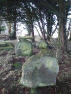
Glesart Stones,
looking west

In the little-known private graveyard of the Struthers family on the crest of the ridge overlooking the River Avon and gazing across landscape stretching for miles into the distance, nearly a mile east of Glassford village, several hundred yards away from the Commonwealth graveyard, a cluster of yew trees hides, not only the 19th century tombstones, but remnants of some thing much more archaic.  Three small standing stones, between 2½ and 4 feet in height, hide unseen under cover of the yews, at the end of a much overgrown ancient trackway which terminates at the site.  They’re odd, inasmuch as they don’t seem to be in their original position.  Yet some form of archaic veracity seems confirmed by the weathered fluting: eroded lines stretching down the faces of two of the taller stones and, more importantly, what seem to be cup-markings on each of the monoliths.
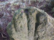
Cup-mark atop of east stone
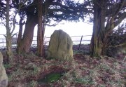
Easternmost stone

The tallest stone at the eastern end of the graveyard has a deep cup on its crown.  This may be the result of weathering; but we must exercise caution with our scepticism here.  Certainly the eroded lines that run down this stone are due to weathering – and many centuries of it; but the peculiarity is that the weathering occurs only on one side.  This implies that only one side of the stone was open to the elements.
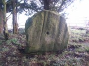
Central cup-marked stone
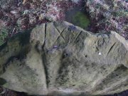
‘X’ carved atop of central stone

The second, central stone of the three, is slightly smaller than the first.  Unlike the eastern stone, its crown has been snapped off at some time in the past century or so, as evidenced in the flat smooth top.  But along the top are a series of small incised marks, one of which includes a notable ‘X’, which may have been surrounded by a circle.  A second fainter ‘X’ can be seen to its side, and small metal-cut lines are at each side of these figures.  Another small section of this stone on its southern edge has also been snapped off at some time in the past.  The most notable element on this monolith is the reasonably large cup-mark on its central west-face.  It is distinctly eroded, measuring 2-3 inches across and an inch or more deep.  Its nature and form is just like the one in the middle of the tallest of the standing stones at Tuilyies, nearly 31 miles to the northeast.
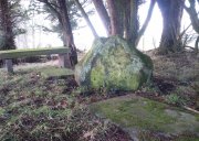
Western smallest stone
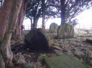
The Three Stones

The smallest of the three stones is just a few feet away from the central stone.  To me, it seemed oddly-placed (not sure why) and had seen the attention of a fire at its base not too long ago.  On its vertical face near the top-centre of the stone, another cup-marking seems in evidence, some 2 inches across and half-an-inch deep—but this may be natural.  The Glasgow archaeologist Kenneth Brophy reported that on a recent visit, computer photogrammetry was undertaken here, so we’ll hopefully see what they found soon enough.

There is some degree of caution amongst some archaeologists regarding the prehistoric authenticity of the Glesart Stanes – and not without good cause.  Yet despite this, the seeming cup-marks and, particularly, the positioning of the stones in the landscape suggest something ancient this way stood.  The stones here are more likely to be the remains of a once-larger monument: perhaps a cairn; perhaps a ring of stones; or perhaps even an early christian site.  At the bottom of the hill for example, just 350 yards below, is a large curve in the River Avon on the other side of which we find the remains of an early church dedicated to that heathen figure of St. Ninian (his holy well close by); and 300 yards north is the wooded Priest’s Burn, whose history and folklore seem lost.

The Glesart Stanes were the subject of an extended article by M.T. M’Whirter in the Hamilton Advertiser in 1929 (for which I must thank Ewan Allinson for putting it on-line).  He wrote:

“Situated on the highest hill-top on the estate of Avonholm, north to the house of that name, is the private burial ground of James Young Struthers… Situated within the burial ground are three upright flagstones of a dark brown colour, rough and unhewn,  Each stone is facing the east, and placed one behind the other, though not in a straight line, and the space between the eastern and the middle stone is eight feet, and the space between the middle and the western stone is seven feet.  The stone flags vary in measurement, the eastern stone being the greater, standing four feet three inches high, three feet eight inches broad, and one foot thick.  The middle stone is three feet high, three feet ten inches broad, and nine inches thick; and the western stone is three feet high, four feet broad and ten inches thick.  The two outer stones bear no letters, figures or marks, but the centre stone has rudely sculptured on the top-edge the Roman numerals IX, and on the western side of the stone there is a cup-shaped indentation about two inches in diameter.  A groove 26 inches in length extends from the top of the stone to below the level of the cup indentation.  The groove is deeper at the top, but gradually loses in depth towards the bottom end.  I have seen grooves similar to above by the friction of a wire rope passing over a rocky surface.  The numerals, cup indentation and groove do not appear to be part of the original placing of the stones and, if a cromlech, then in the centuries that have gone, the stones becoming exposed to view by the removal of the mound, would invariably have led to a search for stone coffins or urns, yet no discovery of either has ever been recorded.”

Indeed, Mr M’Whirter was sceptical of them being part of a prehistoric burial site, preferring instead to think that a megalithic ring once stood here.  He continued:

“From an examination of the three stones, I am convinced that they form a segment of a circle, and assuming that nine additional stones complete the circle, it would enclose a space of roughly one hundred feet in circumference, with each stone facing an easterly direction.”

But we might never know for certain…. The only other literary source I have come across which describes the site is that by the local vicar, William Stewart (1988), who told us that:

“The stones stand erect, six feet apart, three rough slabs of coarse-grained sandstone, three feet high, three feet broad and six inches thick, free of any chisel marks.  Two have their back to the east, the third, oblique to the others, has its back to the south-east, thus there is no suggestion of a stone circle.  There are vertical grooves on two of the stones, while the centre stone has a cupmark, below which is a faint circle, one foot in diameter.  They stand at the end of a long narrow strip of land with low earthen walls on either side, perhaps an old agricultural field division, and they gave their name ‘Three Stanes’, to a now partly-lost road which eventually reached The Craggs and ended as Threestanes Road in Strathaven…”

The Three Stones

The “faint circle” described by Mr Stewart is barely visible now.  And the idea that these “three stones” gave their name to the farmhouse and road of the same name at the other side of Strathaven, three miles west, seems to be stretching credulity to the limits.  Surely?

Folklore

In 1845, Gavin Laing in the New Statistical Account for Lanarkshire told that:

“These stones are known simply as the “Three Stones”. There is a tradition in the neighbourhood that three Lords were buried here, after being killed while looking on at a Battle. The stones are about 3½ feet high and about as thick as flag stones. They stand upright being firmly fixed in the ground.”

The stones and their traditional origin were also mentioned in Francis Groome’s Ordnance Gazetteer (1884), where he echoed the 1845 NSA account, but also added:

“Three tall upright stones are here, and have been variously regarded as Caledonian remains, as monuments of ancient noblemen, and as monuments of martyrs.”

Then at the end of the 1850s, when the Ordnance Survey lads came here, they reported,

“Three high stones stand upright on a small eminence upon the lands of Avonholm, respecting their origin there are various opinions. They are probably the remnants of Druidical superstition.”

References:

  1. Groome, Francis H., Ordnance Gazetteer of Scotland – volume 1, Thomas C. Jack: Edinburgh 1884.
  2. M’Whirter, M.T., “The Standing Stones at Glassford,” in Hamilton Advertiser, 1929.
  3. Stewart, William T., Glasford – The Kirk and the Kingdom, Mainsprint: Hamilton 1988.
  4. Wilson, James Alexander, A Contribution to the History of Lanarkshire – volume 2, J. Wylie: Glasgow 1937.

© Paul BennettThe Northern Antiquarian


Three Stanes, Strathaven, Lanarkshire

Standing Stones (destroyed):  OS Grid Reference – NS 6957 4524

Archaeology & History

Threestanes on the 1864 OS-map

Threestanes on the 1864 OS-map

It seems that nothing remains of the three standing stones that gave rise to the place-name of Threestane Farm, at the top of Threestane Lane, on the northwestern outskirts of Strathaven.  We have no details on the size and form of the stones, nor when they were destroyed, but can presume that it was sometime prior to the Ordnance Survey lads coming here in 1858.

One local antiquarian, Maggie Overett, told that, “Slightly to the north east of Threestanes farm and near to the A726 Strathaven to East Kilbride road used to stand a farm called Westfield(still currently shown on my Google Earth) it was demolished over a year ago. Just behind what was the farm is a slight incline with what appears to be a standing stone. I have not been able to gain access to the site because of barriers put up by whoever owns the plot…… But it’s close enough to tie in the Threestanes estate…….and only a short distance from the known Strathaven Stane.”

Any further information about these lost monoliths would be greatly appreciated.

References:

  1. Bryson, J.M., Handbook to Strathaven and Vicinity, Townehead: Strathaven n.d.

© Paul BennettThe Northern Antiquarian


Stock Well, Glasgow, Lanarkshire

Healing Well (lost):  OS Grid Reference – NS 593 648

Also Known as:

  1. Ratten Well

Archaeology & History

This long lost well near the middle of Glasgow was known by this name as early as 1345.  Close to the River Clyde, a wooden structure was built around the well—a stock—and its waters were used by local fishermen.  A local fair used to be held hereby.  It has long since been built over and its original position no longer seems to be known.

Folklore

The old traditional tale behind this site was written in a short piece in the Scottish Journal of Topography oh so long ago now… One pseudonymous “R.M.S.” said that:

“Stockwell Street in the city of Glasgow, is pretty well-known, and everybody in the locality is aware of the ‘Ratten Well’ with its impure waters.  It is said that, in days of yore, when Sir William Wallace had occasion to be in that quarter, he and his party met a band of englishmen at the well.  A battle ensued, and the bodies of the englishmen, who were defeated, were thrown by the incensed Scots into the well.  “Stock it well! Stock it well” exclaimed Wallace, from which expression the street received its name.  So says tradition; and it is even yet believed that the bad quality of the water is owing to the putrefaction of the dead bodies of the englishmen.”

The one thing we can be certain about in this story, is that the Scots wouldn’t be stupid enough to dump dead bodies into their own fresh water supplies.  We must assume some englishman or dodgy corporation was responsible for that bit!

References:

  1. Bennett, Paul, Ancient and Holy Wells of Glasgow, TNA 2017.
  2. Brotchie, T.C.F., “Holy Wells in and Around Glasgow,” in Old Glasgow Club Transactions, volume 4, 1920.
  3. MacKenzie, Peter, Reminiscences of Glasgow and the West of Scotland – volume 1, John Tweed: Glasgow 1865.
  4. “R.M.S.”, “Stockwell Street, Glasgow,” in Scottish Journal of Topography, Antiquities & Traditions, volume 2, July 8, 1848.

© Paul BennettThe Northern Antiquarian


St. Anne’s Well, Strathaven, Lanarkshire

Holy Well:  OS Grid Reference – NS 7039 4438

Archaeology & History

St Anne's Well on 1865 map

St Anne’s Well on 1865 map

Long since lost it would seem, in a search for this legendary site over the weekend with Gordon, Aisha and Lara, I’m still not certain of the actual status of the site.  Although we found a very fresh water supply still running not far from where the old OS-map showed the original holy well to be, it may be a completely different water source.

There are hardly any references to the spring and those that exist are scant.  In the early 1860s, St. Ane’s Well was mentioned briefly in the Object Name Book of the area:

“This is a good spring well in the southern part of the town of Strathaven.  It is commonly called Tun’s (Tan’s?) Well, but this is an abbreviation of the name.”

Lara plays at a nearby well

Lara plays at a nearby well

Looking down on the waters

Looking down on the waters

More recently, thanks to a communication from the local historian Robert Currie, more information has come to light about the well.  It was described in the local history work by Mary Gebbie (1880).  Mr Currie told me:

“In her Sketches of Avondale and Strathaven…we read: “In a lane off Tod’s Hill was the famous Tann’s Well – obviously a corruption of the celebrated water saint, St. Anne. This spring has within a few years completely dried up. Access was easily had from the castle to it, over the draw-bridge, which is said to have rested on the ledge of the ground and rock on which the fifth house is built south of the bridge. Before this aperture was built up, the inhabitants around took advantage of the pathway for drawing water from the Pomillion, at a place called the Fairy Pool. A little above this comes the Dove Castle; and a half a mile further out is the Gallow Hill.”

He continued:

“That said, the current siting of St. Anne’s Well is located on Lesmahagow Road with (the) site being almost opposite the Council houses bordering on Station Road (there is currently a mini-roundabout near the locus). In recent years the site has become obscured but in my own living memory there was once a plaque authenticating the site and with a garden seat thereby.”

In searching through their own library, Mr Currie and his wife came across more about the site in William Downie’s (1979) book on Strathaven, in which he wrote:

“A small lane off Todshill went down to a cluster of houses called St. Anne’s Well nestling on the sloping ground beside the mill dam. In 1911 these houses were acquired and demolished by the Town Improvement Committee. A row of houses backing backing on to Powmillon Burn were also demolished at the same time and a retaining wall with railings erected, so opening up a very fine view of the castle and burn etc.”

The dedication here to the mythic figure of St. Anne (mother of the Virgin Mary and grandmother of Jesus) is isolated and mysterious.  No church is dedicated to her in the area, nor other relative christian remains.  Her appearance in Strathaven is something of an oddity.  There was a Duchess ‘Ann’ Hamilton of Strathaven Castle who lived 200 yards away at Strathaven Castle on the other side of the river that might have given her name to the well, but this is very unlikely.  More probable is that St. Anne was used as the mythic figure who covered an earlier dedication to the prima mater, or Cailleach—although there are no remains that relate to Her either.  However, the existence of St Mary’s church and an associated well to the north, along with a burn dedicated to a “maiden” in the same parish to the northwest add to the cailleach’s potential…..but all tales of Her have seemingly been forgotten.

…So it seems that the spring of water that Lara, Aisha, Gordon and I came across was obviously not the same place, but exists just below the roadside where the disused railway line is.  It’s close to St Anne’s Well – but is not the same water source.

References:

  1. Downie, Fleming, A History of Avondale and Strathaven, Eric Moore: Glasgow 1979.
  2. Gebbie, Mary, Sketches of the Town of Strathavon and Parish of Avondale: Historical & Traditional, John Menzies: Edinburgh 1880.

Links:

  1. Strathaven Past & Present

Acknowledgements:  Considerable thanks must be given to Robert Currie, BA Hons, who sent us additional information enabling a more informative and accurate site profile for this holy well.  Thanks Bob! Also huge thanks again to Aisha Domleo, Lara Domleo, Unabel Gordon and their frobbling Leonidus!

© Paul BennettThe Northern Antiquarian