St. Anne’s Well, Strathaven, Lanarkshire

Holy Well:  OS Grid Reference – NS 7039 4438

Archaeology & History

St Anne's Well on 1865 map

St Anne’s Well on 1865 map

Long since lost it would seem, in a search for this legendary site over the weekend with Gordon, Aisha and Lara, I’m still not certain of the actual status of the site.  Although we found a very fresh water supply still running not far from where the old OS-map showed the original holy well to be, it may be a completely different water source.

There are hardly any references to the spring and those that exist are scant.  In the early 1860s, St. Ane’s Well was mentioned briefly in the Object Name Book of the area:

“This is a good spring well in the southern part of the town of Strathaven.  It is commonly called Tun’s (Tan’s?) Well, but this is an abbreviation of the name.”

Lara plays at a nearby well

Lara plays at a nearby well

Looking down on the waters

Looking down on the waters

More recently, thanks to a communication from the local historian Robert Currie, more information has come to light about the well.  It was described in the local history work by Mary Gebbie (1880).  Mr Currie told me:

“In her Sketches of Avondale and Strathaven…we read: “In a lane off Tod’s Hill was the famous Tann’s Well – obviously a corruption of the celebrated water saint, St. Anne. This spring has within a few years completely dried up. Access was easily had from the castle to it, over the draw-bridge, which is said to have rested on the ledge of the ground and rock on which the fifth house is built south of the bridge. Before this aperture was built up, the inhabitants around took advantage of the pathway for drawing water from the Pomillion, at a place called the Fairy Pool. A little above this comes the Dove Castle; and a half a mile further out is the Gallow Hill.”

He continued:

“That said, the current siting of St. Anne’s Well is located on Lesmahagow Road with (the) site being almost opposite the Council houses bordering on Station Road (there is currently a mini-roundabout near the locus). In recent years the site has become obscured but in my own living memory there was once a plaque authenticating the site and with a garden seat thereby.”

In searching through their own library, Mr Currie and his wife came across more about the site in William Downie’s (1979) book on Strathaven, in which he wrote:

“A small lane off Todshill went down to a cluster of houses called St. Anne’s Well nestling on the sloping ground beside the mill dam. In 1911 these houses were acquired and demolished by the Town Improvement Committee. A row of houses backing backing on to Powmillon Burn were also demolished at the same time and a retaining wall with railings erected, so opening up a very fine view of the castle and burn etc.”

The dedication here to the mythic figure of St. Anne (mother of the Virgin Mary and grandmother of Jesus) is isolated and mysterious.  No church is dedicated to her in the area, nor other relative christian remains.  Her appearance in Strathaven is something of an oddity.  There was a Duchess ‘Ann’ Hamilton of Strathaven Castle who lived 200 yards away at Strathaven Castle on the other side of the river that might have given her name to the well, but this is very unlikely.  More probable is that St. Anne was used as the mythic figure who covered an earlier dedication to the prima mater, or Cailleach—although there are no remains that relate to Her either.  However, the existence of St Mary’s church and an associated well to the north, along with a burn dedicated to a “maiden” in the same parish to the northwest add to the cailleach’s potential…..but all tales of Her have seemingly been forgotten.

…So it seems that the spring of water that Lara, Aisha, Gordon and I came across was obviously not the same place, but exists just below the roadside where the disused railway line is.  It’s close to St Anne’s Well – but is not the same water source.

References:

  1. Downie, Fleming, A History of Avondale and Strathaven, Eric Moore: Glasgow 1979.
  2. Gebbie, Mary, Sketches of the Town of Strathavon and Parish of Avondale: Historical & Traditional, John Menzies: Edinburgh 1880.

Links:

  1. Strathaven Past & Present

Acknowledgements:  Considerable thanks must be given to Robert Currie, BA Hons, who sent us additional information enabling a more informative and accurate site profile for this holy well.  Thanks Bob! Also huge thanks again to Aisha Domleo, Lara Domleo, Unabel Gordon and their frobbling Leonidus!

© Paul BennettThe Northern Antiquarian


Lady Well, Glasgow, Lanarkshire

Holy Well:  OS Grid Reference – NS 60376 65323

Also Known as:

  1. Canmore ID 45037

Getting Here

Lady Well on 1865 OS-map

Lady Well on 1865 OS-map

Get yourself to Glasgow Cathedral—wherein you’ll find St. Mungo’s Well—and walk down John Know Street.  A coupla hundred yards down, across the road is a small street called Ladywell Lane (there’s no signpost for it though), running below the cemetery and leading to the back entrance of the giant Tennent’s Brewery.  At the bottom of this, up against the wall on your left, is the Lady Well.

Archaeology & History

The origins and early traditional history of this once famous sacred well are sadly lost due to the intrusion of industrialism.  It was obviously a place of some considerable repute and lent its name to local quarries and fields hereby.  Used extensively by local people for countless centuries, things were to change in 1715 when the waters of this and other wells were to be kept clean by one John Black, “at a salary of 400 merks yearly.”  The Glasgow historian Eyre-Todd (1934) told that,

“Black was to furnish them with chains, buckets, sheaves, ladles, and other necessary graith, aswell as with locks and iron bands.  He was ‘to cleanse, muck and keep them clean,’ and to lock and open them in due time, evening and morning.  In case of failure he was liable to a penalty of £100 Scots.”

Lady Well in 2015

Lady Well in 2015

Lady Well in 1883

Lady Well in 1883

That’s a helluva lot of money in those days!  Even when M’Ure (1736) described it, only in passing, he had nothing to say about its curative properties or local rites.  Once the Industrialists take control, the ways of local people are sanitized, sterilized and ‘progress’ outlaws tradition.  The only reference to an earlier sacrality is in Mr Russel’s (1883) article, where he said simply, that the Lady Well was “so called after a fountain at the bottom of the Craigs…sacred in Popish times to the Virgin.”

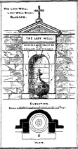
The construction that we see today—of the well in its little enclave—was first built in 1835-6.  The waters became polluted after they were redirected below the Necropolis and have not been used since (although they still flow out of the wall a couple of yards to the right, stinking!).  The architectural feature was cleaned up and restored by the local brewery in 1983.

The site may have gained its name from one Lady Lochow, who lived nearby and built a hospital at the old Gorbels in the 14th century—but we might never know the real truth about the origin of its dedication.  However, an intriguing ingredient relating to the dedication of the Lady Well is the incidence of a St. Anne’s Street that used to exist immediately to the east, as seen on the 1865 OS-map above.  St. Anne may well be the mythic character behind the naming of this Lady Well, although I can find no literature to prove this.  In the christian mythos, St. Anne was a very important character indeed: the mother of the Virgin Mary no less!  However, as hagiographers from Attwater (1965), to Baring-Gould (1898) and Butler (1866) all tell, her biography is piecemeal—which is most surprising considering she was JC’s granny!  Anne’s festival date was July 26 (a couple of days after Sirius enters the northern hemisphere); she was the patron saint of midwives, grandmothers and also miners, who invoked her as the deity who produced gold and silverakin to the Earth Mother Herself!  It’s obvious that Anne’s original mythic nature was subdued, as she represented an archaic root of matriarchal triplicity of the Virgin, the Lady and Old Woman and not the patriarchal triplicity of the incoming christian cult.  The christian mythos at this Lady Well (as elsewhere) replaced one facet of the indigenous prima mater in Glasgow, known as the Cailleach—as shown in her attributes of midwife, grandmother and the deep Earth.  If local historians can find field-names or wells dedicated to the Maiden, the Lady and the Carlin (or their variant titles) nearby, the lost layers of archaic Glasgow’s indigenous animistic folk memories could be mapped out once again…

References:

  1. Attwater, Donald, The Penguin Dictionary of Saints, Penguin: Harmondsworth 1965.
  2. Baring-Gould, S., The Lives of the Saints – volume 8, J.C. Nimmo: London 1898.
  3. Bennett, Paul, Ancient and Holy Wells of Glasgow, TNA 2017.
  4. Brotchie, T.C.F., “Holy Wells in and Around Glasgow,” in Old Glasgow Club Transactions, volume 4, 1920.
  5. Butler, Alba, The Lives of the Fathers, Martyrs and other Principal Saints – volume 7, James Duffy: Dublin 1866.
  6. Eyre-Todd, George, History of Glasgow – volume 3, Jackson: Glasgow 1934.
  7. Greene, E.A., Saints and their Symbols, Sampson Low: London 1897.
  8. MacIntosh, Hugh, The Origin and History of Glasgow Streets, James Hedderwick: Glasgow 1902.
  9. M’Ure, John, History of Glasgow, D. MacVean: Glasgow 1736.
  10. Walker, J. Russel, “‘Holy Wells’ in Scotland,” in Proceedings of the Society of Antiquaries of Scotland, vol.17 (New Series, volume 5), 1883.

© Paul BennettThe Northern Antiquarian


Clach na h-ealea, Clachan, Lismore, Argyll

Legendary Stone:  OS Grid Reference – NM 861 435

Also Known as:

  1. Clach na h-eala
  2. Stone of the Swan
  3. Swan Stone

Archaeology & History

Although the lads at the Scottish Royal Commission (1974) initially described this site as a ‘Standing Stone’, it is in fact,

“an erratic boulder of granite roughly shaped in the form of a cross… It measures 0.8m in height, 0.6m in width at base, and 0.4m in width at the top…(and) the stone is supposed to have marked a boundary.”

The site was evidently of some mythic importance, as the great Cathedral of St. Moluag was built next to the stone — unless the giant cairn of Cnoc Aingil, 500 yards away, was to blame. A holy well of this saint’s name (an obvious heathen site beforehand) is also nearby.

Folklore

Although this stone was dedicated to swans, I’ve not found the story behind the name.  There were no buried swans here, but local tradition told that this old boulder could give sanctuary to anyone who touched it, or ran round it sunwise.  The Hebridean folklorist Otta Swire (1964) told that,

“anyone who claimed such sanctuary had his case considered by ‘the Elders.’ If they considered his plea justified, they ‘came out and walked sun-wise round the Swan Stone.’ If they did not approve of his right to sanctuary, they walked round it anti-clockwise and the man was then given over, not to his enemies, but ‘to Authority’ to be tried.”

This old tradition derives from well known pre-christian rites. Swire also reported that even in the 1960s here, “at funerals the coffin is always carried round the grave sun-wise before being laid in it.” An old cross placed in the Field of the Cross next to the stone was an attempt to tease folk away from heathen rites of the stone, but failed.

References:

  1. Royal Commission on the Ancient & Historical Monuments of Scotland, Argyll – volume 2: Lorn, RCAHMS: Edinburgh 1974.
  2. Swire, O.F., The Inner Hebrides and their Legends, Collins: London 1964.

© Paul BennettThe Northern Antiquarian

St. Murdoch’s Well, Brechin, Angus

Holy Well:  OS Grid Reference – NO 5840 5682

Also Known as:

  1. Canmore ID 34760

Location of the Well

Location of the Well

Getting Here

The well is situated at the roadside on a grassed area at West Drum Cottages, to the east of the minor road from Hillhead of Burghill to Westerton of Aldbar, south of Brechin. The spring issues into a small circular pool, which drains as a burn southwards.

Archaeology & History

James Murray Mackinlay wrote in 1904:

“Murdoch – probably the St Mordouch invoked among the martyrs of the Dunkeld Litany……if we may believe Dempster [Thomas Dempster, 1579-1625 – Historia Ecclesiastica Gentis Scotarum, “Ecclesiastical History of the Scottish Nation.” Bologna 1627], who says that he was a hermit, and had a humble cell near a certain lake in Argyll, his cell being called Kilmurdah. Dempster further says that there was a life of the saint in nine lections, and that the events narrated in it were depicted on the walls of his cell. He is described as the last of the bards, and is said to have lived about 800 a.d.”

Dom Michael Barrett described Murdoch as a bishop, and wrote further in 1919 :

“No very reliable particulars can be ascertained as to the life of this saint. Traces of the honour shown to him are to be found in Forfarshire, the district which seems to have been the scene of his missionary labours. At Ethie, in the parish of Inverkeilor, in that county, are the remains of an ancient church and burial-ground which bear his name.”

Near Ethiebeaton, in the parish of Monifieth, are traces of an old church which goes by the name of ‘Chapel Dockie’. This is believed to be another dedication in honour of St. Murdoch.”

Murdoch may be an anglicisation of either Muireadhach, now Murray, or Muircheartach, which is now Murtough.  Murdoch’s Saint’s day is 2nd September, but 5th October and 23rd December have also been given. And Barrett also writes of a Saint Moroc, who, if what Mackinlay writes is correct, may be the same person as St Murdoch.

Looking into the waters

Looking into the waters

The small run-off from the well

The clear waters of the well

The spring was flowing strongly on the sunny February day of my visit, but its neat appearance gives no idea of it being a Saint’s Well to the passing traveller, who would probably think it to be just a pleasant water feature of the garden of the adjacent house. Perhaps there should be some representations made to the local tourist office for a sign to be placed by the well.

A mile or so to the north, hiding at the edge of a small copse of trees, is the little known holy well of St. Ouret.

References:

  1. Barrett, Dom Michael, A Calendar of Scottish Saints, Abbey Press, Fort Augustus 1919.
  2. Forbes, Alexander Penrose, Kalendars of Scottish Saints, Edmonston and Douglas, Edinburgh 1872.
  3. Mackinlay, James Murray, Influence of the Pre-Reformation Church on Scottish Place-Names, William Blackwood and Sons, Edinburgh & London 1904.

© Paul T. Hornby, The Northern Antiquarian 2016


St. Ouret’s Well, Brechin, Angus

Holy Well:  OS Grid Reference – NO 5869 5904

Getting Here

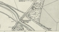
‘Spring’ shown on 1865 map

Travel north towards Brechin on the B9134, and cross the River South Esk at Stannochy Bridge.  Immediately after crossing the bridge, go through the double tubular steel gates to your right, descend the steep slope and walk along the boundary fence dividing the riverside field from the sloping woodland until you reach a tubular steel pedestrian gate. Go through this gate, over the burn and keep walking 150 yards or so to the right and St. Ouret’s Well is seen near the top of the slope.

Archaeology & History

Alexander Penrose Forbes, Bishop of Brechin wrote in 1872 :

Ouret – Close to Brechin, on the north bank of the Esk, near the Stannochy Bridge, is S.Ouret’s Well.”

The spring flows south into a burn then into the river South Esk

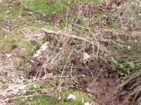
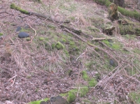
Perusal of the 25″ OS map of 1865 shows an enclosure marked ‘spring’ with a short pathway to the north-east, as the only water feature answering the written description. My field visit just over a century and a half later found a spring issuing at that point from the embankment, with the remains of old rough stone walling on either side of the spring. There was no sign of the pathway. The walling around an otherwise unremarkable spring located away from habitation would imply to me that this is the Saint’s Well.

As the good Bishop mentions the Well as the last entry in the Auctaria of his 1872 book—an afterthought as you will—it seems reasonable that the knowledge of St. Ouret and his well may have been at that time on the point of oblivion. The well is not noted as such by the earlier Ordnance Survey map,  nor can I find his name in any other of the hagiographies at my disposal.

Old walling still visible low down

Intriguingly, ‘Ouret’ is a modern Basque surname, and while it is tempting to think of a Basque Holy Man walking the Pictland, the name is more likely a transliteration into Scots from a now lost Pictish or Gaelic name.  There is a mysterious ‘Uoret’ named in the inscription (as interpreted by Elisabeth Okasha) ‘DROSTEN : IRE UORET [E]TT FORCUS’  on the Drosten Stone at St Vigeans, who may be our saint, but this Uoret has been interpreted by Thomas Clancy as the Pictish King Uurad, son of Bargoit, who ruled from 839 to 842.  I know of no reference as to where Forbes obtained his information on Ouret or his well, but is it reasonable to hypothesise that the information was passed to him orally and what he wrote down as ‘Ouret’ may have been meant to be the very similar sounding ‘Uoret’? Or alternately was King Uurad  subjected to local canonisation as St Uoret/Ouret after his death? Can anyone add more?

A mile or so south of here is the holy well of St. Murdoch.

References:

  1. Forbes, Alexander Penrose, Kalendars of Scottish Saints, Edmonston and Douglas: Edinburgh 1872.
  2. Dwelly, Edward, Gaelic – English Dictionary, Garmin Publications: Glasgow 1988

© Paul T. Hornby,  The Northern Antiquarian 2016


Black Prince’s Well, Harbledown, Kent

Holy Well: OS Grid Reference – TR 129 582

Also known as:

  1. Leper Well
  2. St. Thomas’s Well

Getting Here

The Black Prince’s Well is found to the right of a path that curves around past the Leper Hospital / almshouses, and through the forecourt of a house.

Archaeology & History

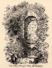
Black Princes Well

Black Princes Well

Behind the old leper hospital, and to the west of the Church, is the Black Prince’s Well, a holy well of some renown and interest. For Canterbury pilgrims, the well was a significant watering hole before they made the last steps to that great Shrine of St. Thomas. According to Watt (1917) this was the seventh St. Thomas’s Watering at Harbledown. It still bears the alternative name of St. Thomas’s Well, a dedication unlike other sites would seem to be related to be a direct relationship, for it is recorded that he drunk from the well, accidentally leaving a shoe. Understandably, after the martyrdom, this became an important relic, and was held by the Hospital.

The spring emerges at the foot of the hill, enclosed in a six foot high semicircular domed well head made from rag stone. Most interesting a carved stone, in its central apse, depicts the Black Prince’s coat of arms, three feathers taken from the King of Bohemia at Crecy. This stone appears to havebeen possibly derived from another structure rather than being carved especially for the well head, as do the fluted stones shown in earlier photos (cf Goodsall (1968) in his Kentish Patchwork), which are now apparently missing. Either side of the well head are two courses of rag stone walling. The well is reached by a series of stone steps between two courses of stone walling. The water emerges, as a small trickle, through a five inch diameter red clay pipe, flowing to fill a circular basin.

Folklore

The well was noted as being able to cure leprous ailments, and presumably this is why the leper hospital was built in 1084 by Archbishop Lanfranc to exploit its properties. Among its many early pilgrims looking for a cure for this complaint was Edward the Black Prince, who patronised the well twice: the first on his last journey to Canterbury, when he was cured, and then finally, on his death bed in 1376. Unfortunately in this latter case the waters were obviously of no use, being unable to rid him of his syphilis, of which he died. The well subsequently named after the knight. For those unable to drink straight from the well, water was often administered to those living far from it. Evidence for this being the discovery of a leather pouch found near the well. Indeed, even the early part of this century the water was still used, especially by those from afar, for Snowdon Ward (1904) remarks that:

“the water is still in some repute for its curative powers. The sub-prior of the hospital told us that he still occasionally receives small remittances from various parts of the continent…”

Cartwright (1911) illustrates that its local reputation was still current before the Great War. He records that it was:

‘still believed by Country folks to be of great benefit to the eyes.’

Certainly the well is one of the most interesting and enchanting of Kent wells.

(taken from the forthcoming Holy Wells and Healing Springs of Kent)

Links:  http://www.insearchofholyandhealingwells.wordpress.com

© R.B. Parish, The Northern Antiquarian and Pixyledpublications


St. Peter’s Well, York Minster, North Yorkshire

Holy Well:  OS Grid Reference – SE 6038 5219

Also Known as:

  1. Holy Well, York Minster

Archaeology & History

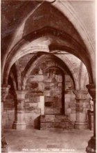
Old photo of the well

For people who like to visit the sacred sites that determined a cross-over from Earth-based animism to one which ceased sanctifying the Earth, this ancient water source in the cellars beneath York Minster would be a good example.  Sadly, the church has closed off access to this ancient heritage and you can no longer see it.  Yet despite the fact that the modern-day christians have closed off your encounter with this important heritage site (York Minster’s website doesn’t even mention its existence!), we should not forget its mythic history…

As you walk into the building (at some great expense, it has to be said), the location of the holy well is said to be at its more western end, albeit in the crypt underground—although there does seems to be some confusion with some authors about exactly where the well is positioned.

1850 sketch of well

The earliest account we hear of the place relates to when the northern tribal King Edwin, along with his sons Osfrid and Esfrid, came here to be “baptized” in the waters of this clear spring “on Easter day, April 12, 627” CE.  Immediately thereafter a small wooden chapel was constructed next to or above the well.  From then on, as the centuries passed, the renown of the well grew and eventually the magnificent ritual temple of York Minster was eventually built.  The waters eventually became dedicated to St. Peter and an annual festival occurred here soon after the Midsummer solstice on what became known as St. Peter’s Day (June 29).  After the year 1462, a secondary festival date was also given to the site by the Church and another annual celebration occurred here on October 1 too.  Its waters remained accessible to people for drinking, healing and rites throughout the centuries.  It is only now, in the 21st century, that its sacrality and spirit has been closed-off.  This is a situation that must be remedied!


In Mr Goole’s (1850) survey of York Minster, his architectural illustration of the building showed that the water from the well had been brought up onto the ground floor, on the southeast side of the inner cathedral building in the easternmost vestry, and named as St Peter’s Pump.  This is illustrated in the 1850 drawing above-left.

A whole series of early writers mention the well in earlier centuries—of whom a brief sample is given here.  When Celia Feinnes came here in the 17th century, she said that,

“In the vestry of York Minster there is a well of sweet spring water called St Peter’s Well ye saint of ye Church, so it is called St Peter’s Cathedral.” (Smith 1923)

Mr Torre (1719) gave it equal brevity, saying simply that,

“at the south-west corner thereof is a draw-well (called St. Peter’s Well) of very wholesome clear water much drunk by the common people.”

In R.C. Hope’s (1893) national survey of sacred wells, he told that

“There is a draw well with a stone cistern in the eastern part of the crypt of York Minster… The Crypt is about 40 feet by 35 feet.”

The well was even included in Murray’s Handbook to Yorkshire (1892) as being “in the southwest corner of the Minster.” William Smith (1923) included the site in his fine survey, telling his readers that,

“The water is excellent in quality, which in measure, so chemists say, is due to the lime washed into it by the rain from the walls of the Minster.  The water has for centuries been used for baptisms, and is so used today.  The well has now for some years been covered with a pump.”

Folklore

In Geoffrey of Monmouth’s famous early History, we find that King Arthur visited here. …And one final note, about which we know not for certain whether it was relevant to the holy well hiding in the crypt, but a fascinating heathen custom was enacted here in bygone days, almost above the spring.  Mistletoe, as Christina Hole (1950) told,

“was ceremonially carried to the cathedral on Christmas Eve and laid upon the high altar, after which a universal pardon and liberty for all was proclaimed at the four gates of the city for as long as the branch lay upon the altar.”

Mistletoe is one element that is known to have been sacred to the druids (not the present-day druids!) and was sacred to the ancient Scandinavians (who came here), and also possessed the powers of life and death in its prodigious folklore and phytochemistry.  Fascinating…

…to be continued…

References:

  1. Bord, Janet, Cures and Curses: Ritual and Cult at Holy Wells, HOAP: Wymeswold 2006.
  2. Gutch, Mrs, County Folk-lore volume 2 – North Riding of Yorkshire, York and the Ainsty, David Nutt: London 1901.
  3. Hole, Christina, English Custom and Usage, Batsford: London 1950.
  4. Hole, Christina, English Shrines and Sanctuaries, Batsford: London 1954.
  5. Hope, Robert Charles, Legendary Lore of the Holy Wells of England, Elliott Stock: London 1893.
  6. Murray, John, Handbook for Travellers in Yorkshire, J.Murray: London 1874.
  7. Parkinson, Thomas, Yorkshire Legends and Traditions, Elliot Stock: London 1888.
  8. Poole, G.A., An Historical and Descriptive Guide to York Cathedral and its Antiquities, R. Sunter: York 1850.
  9. Purey-Cust, A.P., York Minster, Isbister: London 1898.
  10. Rattue, James, The Living Stream: Holy Wells in Historical Context, Boydell: Woodbridge 1995.
  11. Smith, William, Ancient Springs and Streams of the East Riding of Yorkshire, A. Brown: Hull 1923.
  12. Torre, James, The Antiquities of York, York 1719.
  13. Whelan, Edna, “Holy Wells in Yorkshire – part 1,” in Source, No.3, November 1985.
  14. Whelan, Edna, The Magic and Mystery of Holy Wells, Capall Bann: Chieveley 2001.
  15. Whelan, Edna & Taylor, Ian, Yorkshire Holy Wells and Sacred Springs, Northern Lights: Dunnington 1989.

© Paul Bennett, The Northern Antiquarian

St. Helen’s Well, Thorpe Hesley, South Yorkshire

Holy Well (lost): OS Grid Reference – SD 370 960

Archaeology & History

In Rob Wilson’s (1991) study on the saints and wells of South Yorkshire, he mentions this site which, it would seem, may have been lost to history.  In Wilson’s site-entry for the St. Helen’s Well at nearby Barnburgh, he tells that,

“There may have been other wells in South Yorkshire dedicated to St. Helen… Two 18th century surveys by William Fairbank list St. Helen’s Fieldin Thorpe Hesley and St. Ellen’s Field in Wentworth.”

Around ten different wells are highlighted in the village itself on the first Ordnance Survey map of the area, with a number of others scattered in the surrounding fields.  Any one of these may be the well in question.  Much of the region was badly disfigured by the Industrialists in their usual desecration of the landscape, which may make any recovery of this site impossible.  However, a foray into the whereabouts of William Fairbank’s survey could be worthwhile — and if St. Helen’s Field is one that remained untouched by local mining, the site could be recovered from its present “lost” status.

(Please note: the grid-reference cited above is an approximation until further data allows us to correct it.)

References:

  1. Wilson, Rob, Holy Wells and Spas of South Yorkshire, Northern Arts: Sheffield 1991.

© Paul BennettThe Northern Antiquarian


St Francis’ Well, Conisborough, South Yorkshire

Holy Well:  OS-Grid Reference – SK 5112 9880

Also known as:

  1. Town Well

Getting Here

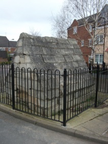
From Church street turn down into Wellgate, the well is on the right hand site at 18 Wellgate surrounded by railings near some new properties, on a little island.

Archaeology & History

Near the castle, and although dry it is a substantial site variously called the Town well or the Well of St Francis.  This is as C.F. Innocent (1914) described it:

“Covered by a curious little building very medieval-looking  with it a chamfered plinth and steeply slanted roof”

Little is recorded of its history, but the structure more a conduit house probably dates from the 1500s at the earliest and was used as source of domestic water until the 1900s.

Folklore

Which St Francis it is, is unclear, but Alport (1898) records the local tradition which states that he was a local holy man and probably not a true saint and it is interesting that a number of churches are dedicated to a St. Francis in Yorkshire. Interestingly though, the date of creation of the well is recorded and is quite late compared to other local saints.

It is said that in 1320 -1321 the village was suffering from a particularly terrible drought and this St. Francis, said to be an old and wise man was sought for his advice. He suggested that the local people cut a willow tree from Willow Vale and then as the people sang psalms and hymns he lead them through the church and priory grounds to the site of the well. At the spot St Francis then struck is and not only did a spring arise and followed for the next 582 years (for its sadly dry now) but the tree took root.

Sadly this tree has either died or was dug up. Clark (1986) believes the story recalls a Pagan priest and that the legend was a legacy of Conisbrough’s pre-Christian past; certainly the reference to a willow indicates a water diviner.

Extracted and amended (where both sites of the town are discussed) from http://insearchofholywellsandhealingsprings.wordpress.com/2011/12/11/a-yorkshire-field-trip-conisboroughs-two-holy-wells/

References:

    1. Allport, C.H., (1898) History of Conisborough.
    2. Clark, S., (1986) “The Holy well of Conisborough,” in Source, Old Series no.5.
    3. Innocent, C.F (1914-18) “Conisborough and its Castle,” in Trans of Hunter Archaeology Society.

© Ross Parish


St Peter’s Well, York Minster, North Yorkshire

Holy Well:  OS Grid Reference – SE 6038 5219

Also Known as:

  1. Holy Well, York Minster

Archaeology & History

Old photo of the well

Old photo of the well

For people who like to visit the sacred sites that determined a cross-over from Earth-based animism to one which ceased sanctifying the Earth, this ancient water source in the cellars beneath York Minster would be a good example.  Sadly, the church has closed off access to this ancient heritage and you can no longer see it.  Yet despite the fact that the modern-day christians have closed off your encounter with this important heritage site (York Minster’s website doesn’t even mention its existence!), we should not forget its mythic history…

As you walk into the building (at some great expense, it has to be said), the location of the holy well is said to be at its more western end, albeit in the crypt underground—although there does seems to be some confusion with some authors about exactly where the well is positioned.

1850 sketch of the well

1850 sketch of the well

The earliest account we hear of the place relates to when the northern tribal King Edwin, along with his sons Osfrid and Esfrid, came here to be “baptized” in the waters of this clear spring “on Easter day, April 12, 627” CE.  Immediately thereafter a small wooden chapel was constructed next to or above the well.  From then on, as the centuries passed, the renown of the well grew and eventually the magnificent ritual temple of York Minster was eventually built.  The waters eventually became dedicated to St. Peter and an annual festival occurred here soon after the Midsummer solstice on what became known as St. Peter’s Day (June 29).  After the year 1462, a secondary festival date was also given to the site by the Church and another annual celebration occurred here on October 1 too.  Its waters remained accessible to people for drinking, healing and rites throughout the centuries.  It is only now, in the 21st century, that its sacrality and spirit has been closed-off.  This is a situation that must be remedied!

In Mr Goole’s (1850) survey of York Minster, his architectural illustration of the building showed that the water from the well had been brought up onto the ground floor, on the southeast side of the inner cathedral building in the easternmost vestry, and named as St Peter’s Pump.  This is illustrated in the 1850 drawing above-left.

A whole series of early writers mention the well in earlier centuries—of whom a brief sample is given here.  When Celia Feinnes came here in the 17th century, she said that,

“In the vestry of York Minster there is a well of sweet spring water called St Peter’s Well ye saint of ye Church, so it is called St Peter’s Cathedral.”(Smith 1923)

Mr Torre (1719) gave it equal brevity, saying simply that,

“at the south-west corner thereof is a draw-well (called St. Peter’s Well) of very wholesome clear water much drunk by the common people.”

In R.C. Hope’s (1893) national survey of sacred wells, he told that

“There is a draw well with a stone cistern in the eastern part of the crypt of York Minster… The Crypt is about 40 feet by 35 feet.”

The well was even included in Murray’s Handbook to Yorkshire (1892) as being “in the southwest corner of the Minster.” William Smith (1923) included the site in his fine survey, telling his readers that,

“The water is excellent in quality, which in measure, so chemists say, is due to the lime washed into it by the rain from the walls of the Minster.  The water has for centuries been used for baptisms, and is so used today.  The well has now for some years been covered with a pump.”

Folklore

In Geoffrey of Monmouth’s famous early History, we find that King Arthur visited here. …And one final note, about which we know not for certain whether it was relevant to the holy well hiding in the crypt, but a fascinating heathen custom was enacted here in bygone days, almost above the spring.  Mistletoe, as Christina Hole (1950) told,

“was ceremonially carried to the cathedral on Christmas Eve and laid upon the high altar, after which a universal pardon and liberty for all was proclaimed at the four gates of the city for as long as the branch lay upon the altar.”

Mistletoe is one element that is known to have been sacred to the druids (not the present-day druids!) and was sacred to the ancient Scandinavians (who came here), and also possessed the powers of life and death in its prodigious folklore and phytochemistry.  Fascinating…

…to be continued…

References:

  1. Bord, Janet, Cures and Curses: Ritual and Cult at Holy Wells, HOAP: Wymeswold 2006.
  2. Gutch, Mrs, County Folk-lore volume 2 – North Riding of Yorkshire, York and the Ainsty, David Nutt: London 1901.
  3. Hole, Christina, English Custom and Usage, Batsford: London 1950.
  4. Hole, Christina, English Shrines and Sanctuaries, Batsford: London 1954.
  5. Hope, Robert Charles, Legendary Lore of the Holy Wells of England, Elliott Stock: London 1893.
  6. Murray, John, Handbook for Travellers in Yorkshire, J.Murray: London 1874.
  7. Parkinson, Thomas, Yorkshire Legends and Traditions, Elliot Stock: London 1888.
  8. Poole, G.A., An Historical and Descriptive Guide to York Cathedral and its Antiquities, R. Sunter: York 1850.
  9. Purey-Cust, A.P., York Minster, Isbister: London 1898.
  10. Rattue, James, The Living Stream: Holy Wells in Historical Context, Boydell: Woodbridge 1995.
  11. Smith, William, Ancient Springs and Streams of the East Riding of Yorkshire, A. Brown: Hull 1923.
  12. Torre, James, The Antiquities of York, York 1719.
  13. Whelan, Edna, “Holy Wells in Yorkshire – part 1,” in Source, No.3, November 1985.
  14. Whelan, Edna, The Magic and Mystery of Holy Wells, Capall Bann: Chieveley 2001.
  15. Whelan, Edna & Taylor, Ian, Yorkshire Holy Wells and Sacred Springs, Northern Lights: Dunnington 1989.

© Paul BennettThe Northern Antiquarian