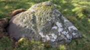
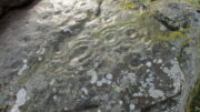
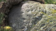
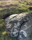
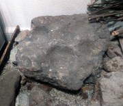
Whitelaw, Kirknewton, Northumberland

Cup-and-Ring Stone (lost):  OS Grid Reference – NT 942 295

Also Known as:

  1. Whitelaw Stone

Archaeology & History

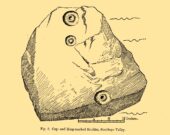
Sometime at the end of the 1860s, a local man—Mr William Wightman of Wooler—was in possession of this impressive-looking petroglyph which, we presume, he uncovered.  The carved stone was, as we can see, broken off from a larger piece and so it’s very evident that this was originally a larger design than the one illustrated here in Mr Middlemass’ (1872) drawing.  The only information we have about it are from his short notes,

The Whitelaw Stone

“was found on the north side of a hill called Whitelaw, the next eminence south-east from Yeavering Bell.  The stone is a very hard gritty sandstone, and bears distinctly the tool marks by which the circles have been cut. The tool must have been of iron or bronze, as the material is too hard to be operated upon by stone implements; moreover, the tool marks shew that the instrument used had a sharp round point, and must have been held in a similar way to the modern chisel.  The marks shew the size of the point.  The object of the artist evidently has been to fill the stone with ornament as between the two great circles; and at the corners he has placed smaller circles to suit the space. The similar nature of the circles on all the stones hitherto figured would seem to show that such stones, if monumental, were not legendary, but, most probably of a religious character; serving, like the Christian cross, to invite the traveller to pay his devotions on a spot rendered sacred by the emblems of worship.”

Searches for this have been made by Stan Beckensall (1983) and his acolytes, but it remains lost. (the grid-ref is an approximation)

References:

  1. Beckensall, Stan, Northumberland’s Prehistoric Rock Carvings – A Mystery Explained, Pendulum: Rothbury 1983.
  2. Middlemass. Robert, “On an Inscribed Stone in the Possession of Mr William Wightman, Bank, Wooler,” in History Berwickshire Naturalists Club, volume 6, 1869-72.

© Paul BennettThe Northern Antiquarian

Soonhope, Peebles, Peeblesshire

Cup-and-Ring Stone (lost): OS Grid Reference – NT 269 419

Also Known as:

  1. Kittlegairy Burn

Archaeology & History

Fred Coles’ 1898 sketch

An apparently isolated cup-and-ring stone was found on the hills north of Peebles at the end of the 19th century by the renowned Scottish megalith explorer, Fred Coles. (1899)  He was having a look at some of the hillforts in the area and—as some of us tend to do—he began meandering off-track, down streams, through bogs and as a result came across the carving that’s illustrated here.  It’s subsequently become “lost” in the hills, but it shouldn’t be too difficult to locate, as the description he gave of its whereabouts is a pretty good one.  He told us:

“A very little over one mile and a quarter up the valley, measuring from the road at Kerfield Cottage, a tiny rivulet called Kittlegairy Burn trickles down from the SE into the main stream.  On the hill to its east, and about 450 feet higher, are the remains of a fort, one of a series of three crowning prominent heights along this side of the valley.  Down the main stream from Kittlegairy Burn is a large ruined sheep-shelter called Soonhope.  Nearly midway between these two points a deep curve has been hollowed out of the E. bank; and, at the foot of this rather high gravel bank, half immersed in the stream, lies the block of stone with the cup-and ring-marks.  They were discovered, 14th September 1896, by my daughter, Helen, on crossing the stream; and we at once proceeded to make a measured drawing, a reproduction of which is given here….  The depth of the rings in proportion to their width is the one most noticeable feature; next, the extreme thinness of the intervening ‘neck’; but, on a minute and careful examination of the nature of the stone itself, taking into consideration that its angularity and sharpness of edge and the absence of moss or even of confervoid growths on its surfaces went against the possibility of its being truly waterworn.”

The rock had obviously fallen from its original position above the burn.  Today, the entire area where this stone exists has been covered by a huge forestry plantation, but if any rock art fanatics from the Peebles area get bored one day and have nothing to do…..

References:

  1. Coles, Fred, “Notices of the Discovery of a Cist and Urns at Juniper Green, and of a Cist at the Cunninghar, Tillicoultry, and of some Undescribed Cup-marked Stones’, in Proceedings Society Antiquaries, Scotland, volume 33, 1899.
  2. Morris, Ronald W.B., “The Cup-and-Ring and Similar Early Sculptures of Scotland; Part 2 – The Rest of Scotland except Kintyre,” in Transactions of the Ancient Monuments Society, volume 16, 1969.
  3. Morris, Ronald W.B., “The cup-and-ring marks and similar sculptures of Scotland: a survey of the southern Counties – part 2,” in Proceedings of the Society of Antiquaries, Scotland, volume 100, 1969.
  4. Morris, Ronald W.B., The Prehistoric Rock Art of Southern Scotland, BAR: Oxford 1981.

© Paul BennettThe Northern Antiquarian

Harelawside, Grantshouse, Berwickshire

Cup-and-Ring Stone (removed): OS Grid Reference – NT 807 659

Archaeology & History

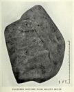
A carving that no longer exists in its place of origin, but can now be seen in the National Museum of Antiquities in Edinburgh.  It was discovered by a Mr James Craw (1931), who gave us the following account of his find:

“In 1910 my attention was attracted by some markings on a boulder on the top of a field wall, ¼-mile NNW of Grant’s House church and at an elevation of some 550 feet above sea level.  The stone was a rounded and somewhat flattened slab of greenstone, measuring 22 inches by 17 inches by 4 inches… It bore a small cup ½-inch in diameter, surrounded by two rings of shallow incision, the outer being 3 inches in diameter.  From the cup a duct, partly natural, led across the stone, and another cup, without rings, had also a short duct.  Adjacent to these markings was a curious grid design of shallow lines, a series of parallel lines ¼-inch apart, being crossed at right angles by lines 2½ inches apart.”

1930 photo of the carving

Across a section of the stone there may also be a curving pecked line which Craw didn’t appear to notice.  The parallel lines would appear to have quite separate origins, with those running below the cup-and-ring seeming to be ancient, whereas the others have the appearance of being cut with metal tools and seem much more like modern scarring.

Shortly after finding the stone, Mr Craw took the petroglyph to the National Museum in Edinburgh, where he was told that they didn’t think it “as being of early workmanship, the cups and rings being of much smaller proportions than the typical markings of the Bronze Age and the grid design having no known parallel.”  They were wrong on both accounts of course, although I for one still remained unconvinced by one set of parallel lines that run along to the edge of the stone.  That said, there are similar carvings of parallel lines at the impressive Traprain Law 15 miles northwest of here, so I may be wrong.

The wall in which this carving was found was obviously not its place of origin.  It most likely came from one of the cairns that was reported by J. Hardy to have been destroyed in this field in 1882.

References:

  1. Craw, James H., “An Inscribed Boulder from Grants House,” in History of Berwickshire Naturalists Club, volume 27, 1931.
  2. Edwards, Arthur J.H., “Rock Sculpturings on Traprain Law,” in Proceedings Society of Antiquaries, Scotland, volume 69, 1935.
  3. Morris, Ronald W.B., “The Cup-and-Ring and Similar Early Sculptures of Scotland; Part 2 – The Rest of Scotland except Kintyre,” in Transactions of the Ancient Monuments Society, volume 16, 1969.
  4. Morris, Ronald W.B., “The cup-and-ring marks and similar sculptures of Scotland: a survey of the southern Counties – part 2,” in Proceedings of the Society of Antiquaries, Scotland, volume 100, 1969.
  5. Morris, Ronald W.B., The Prehistoric Rock Art of Southern Scotland, BAR: Oxford 1981.

© Paul BennettThe Northern Antiquarian

Drumderg (2), Tullymurdoch, Perthshire

Cup-and-Ring Stone:  OS Grid Reference – NO 18523 54950

Getting Here

Drumderg (2) cup-and-ring

Two ways: i) up the A93 road from Blairgowrie, after 5 miles turn right at the Bridge of Cally and up Glen Shee.  After another 3½ miles, keep your eyes peeled for the tiny road on the right signposted to the Drumturk Cheese farmshop.  Go up this long tiny winding road for a mile up to the cheese place and keep on this road for another 2¼ miles where you can park up near the entrance to the huge wind-farm; or – (ii) from Alyth, go up the long winding tiny Bamff Road and keep to the signposts for Bridge of Cally Glen Shee until, after about 4 miles, you reach the entrance to the windfarm.  Walk up the track to the windmills, bearing right at the first junction, then right again at the next one.  From here, shortly before the second windmill, walk down into the moor for nearly 200 yards. It’s quite a large stone.

Archaeology & History

Interlocking rings close-up

This is impressive.  Very impressive!  Found within a huge mass of other prehistoric sites in the Forest of Alyth, its only known petroglyphic bedfellows—Drumderg (1) nearly 500 yards yards south, and Drumderg (3) 120 yards north—have nothing on this one!  Where the others have basic cupmarks, this bears a series of multiple interlocking cup-and-ring designs, some with one ring, others with two, and one with four, albeit incomplete rings.

The design is etched onto the sloping face of a curved triangular ‘female’ stone.  An eroded cutting all but separates the two main components of the design, but this cut has within it a distinct singular cup-and-ring almost linking each side together.  On one side (which is near the middle of the stone) we have a complex series of multiple cup-and-rings that seem to be sequentially moving and (almost) growing into each other in some form of organic pattern.  The bottom of this growth begins from a standard cup-and-ring and runs immediately into a vulva-like slit of a cup-mark surrounded by four incomplete rings.  As the photos show, this keeps climbing upwards.

Cupmarks on its W-side
Looking into the setting sun

A more simplistic basic design has been etched onto the more western side of the stone, on the other side of the eroded cutting.  Two of the cup-marks have rings around them, with one of them seeming to give birth to another upward “growth”, but this time comprising merely of a line of more cups, curving ever-so-gently towards the middle of the stone.  Along with this there are also cup-marks on the top ridge of the stone; faint carved lines curve and intersect.  Movement seems embedded in this fixed non-linear design.  That’s my impression anyhow!

The only literary attention given to the carving seems to have been by the Scottish Royal Commission (1990) lads in one of their Perthshire inventories.  It’s simple as always, telling basically,

“this heavily weathered cup-and-ring marked boulder lies 150m south of the hut circles… The carvings are on the southwest face of the boulder and comprise: at least four cups surrounded by single rings; two cups surrounded by triple rings; an oval cup measuring 100mm by 70mm surrounded by four rings; and twenty-two plain cups marks, the largest 60mm in diameter.”

If there’s anything extra that we should puzzle over, it’s this: why do we have such an intricate carving here, living in near isolation in the midst of countless other prehistoric remains?  The answer, most likely, is that it’s not alone.  I highly suspect that others are waiting to be found up here beneath the endless ocean of heather…

References:

  1. Royal Commission on the Ancient & Historical Monuments of Scotland, North-East Perth: An Archaeological Landscape, HMSO: Edinburgh 1990.

© Paul Bennett, The Northern Antiquarian

Cartington Cove, Rothbury, Northumberland

Cup-and-Ring Stone (destroyed):  OS Grid Reference – NU 0444 0186

Archaeology & History

In an area teeming with prehistoric sites from the neolithic and Bronze Age periods, we had a rare example here of some cup-and-rings that had been carved within a small cave or rock shelter of some kind.  Sadly it got destroyed in the mid-19th century due to quarrying operations—but not before George Tate (1864; 1865) had a final sniff of the place and was very lucky to see some of the remains before they finally bit-the-dust.  He told us:

“The great sandstone ridge ranges from Eglingham and Beanley across the central part of the county towards Rothbury, near to which is a cave in the rock called “Cartington Cove;” concentric circles with central hollows were incised within this cave.  Mr. Williamson of Alnwick, from whom I had this information, played around them when a boy more than fifty years ago; and they were then popularly called “Cups and Saucers.”  Nearly all of them have been destroyed by the wedges and hammers of quarrymen; but on visiting the spot in 1859, I found sufficient traces to confirm Mr. Williamson’s testimony.”

But they were gone a few years later thanks to the lads at the quarry.  Although the site was subsequently described in Beckensall’s modern surveys (1992; 2006), nothing more was found about them.

Folklore

Whilst David Dixon (1903) reiterated Mr Tate’s notes on the “series of incised concentric circles and central hollows” here, he also mentioned an old piece of folklore:

“At Cartington Cove (is) a recess or cave which, local tradition says, is connected by a subterranean passage with Cartington Castle, three miles distant!”

Intriguing ingredients: caves – Underworld journey – north – all symbolic of Death in pre-christian lore.  Just saying…

References:

  1. Beckensall, Stan, Prehistoric Rock Motifs of Northumberland – volume 2, Abbey Press: Hexham 1992.
  2. Beckensall, Stan, Circles in Stone: A British Prehistoric Mystery, Tempus: Stroud 2006.
  3. Dixon, David D., Upper Coquetdale, Northumberland, Robert Redpath: Newcastle-upon-Tyne 1903.
  4. Tate, George, “The Ancient British Sculptured Rocks of Northumberland and the Eastern Borders,” in History of the Berwickshire Naturalists Club, volume 5, 1864.
  5. Tate, George, The Ancient British Sculptured Rocks of Northumberland and the Eastern Borders, Henry Hunter Blair 1865.

© Paul BennettThe Northern Antiquarian

Yeavering, Kirknewton, Northumberland

Cup-and-Ring Stone (lost):  OS Grid Reference – NT 931 302

Archaeology & History

Little is now known of this carving which was described briefly by Stan Beckensall (1983):

“A cup and ring marked stone was found in the field north of Yeavering Bell in the neighbourhood of the monolith.  The last heard of it, according to the Northumberland County History (14:67) was that it was in the grounds of Ewart Park.”

The monolith he speaks of would be the one called the Battle Stone (NT 9299 3038) and Ewart Park is 2 miles ENE of here.  The carving remains lost. (the grid reference where the stone was originally located is an approximation, but a pretty good one)

References:

  1. Beckensall, Stan, Northumberland’s Prehistoric Rock Carvings – A Mystery Explained, Pendulum: Rothbury 1983.

© Paul BennettThe Northern Antiquarian

Peace Stone, Port of Menteith, Stirlingshire

Cup-and-Ring Stone:  OS Grid Reference – NS 56413 99540

Also Known as:

  1. Canmore ID 44622
  2. Gartrenich
  3. Milling
  4. Menteith 1

Getting Here

Peace Stone cup-and-ring

The quickest way here is bedevilled with troublesome parking (and an unhelpful local at Malling Cottage).  That aside, roughly halfway along the A81 between the Braeval roundabout (near Aberfolye) and Port of Meneith, turn down the track at Malling, following it round for 300 yards through the farm, then another 500 yards or so until you reach a junction with a gate on your left. Walk down the track to your right, roughly alongside the Lake of Menteith, for nearly 700 yards until you reach the gate into the forestry commission land. Go thru the gate and turn immediate right, following the fence for about 200 yards where a clump of stones lives. You’re there!

Archaeology & History

The Peace Stone in 1899

This seemingly isolated petroglyph, known about by local people in the middle of the 19th century and earlier, was said to have been “held in great reverence.”  It was first mentioned in literary accounts in 1866, when the oral traditions about it were more important than any archaeocentricism.  But things change with the times: local people were kicked off their lands, old stories and knowledge of sites were lost, and the ‘discipline’ of archaeology was beginning to look at these curious carved rocks with puzzled minds.

The Peace Stone was described at some length and with considerable accuracy in Mr A.F. Hutchison’s (1893) gazetteer on the ancient stones of Stirlingshire.  It was one of the regions only known petroglyphs at that time and thankfully he gave us a good account of it, saying:

“On the west ride of the Lake of Menteith, about half a mile south from the farm-house of Malling, this stone is to be found, lying at the boundary of the arable land. The ground at the place rises into a slight eminence, on the top of which the stone lay till some seven or eight years ago, when a labourer took it into his head that a stone on which so much labour had evidently been spent must have been intended to cover something valuable. He proceeded to excavate the earth at the side with the intention of getting at the buried treasure, with the result that the stone slipped down into the hole which he had made, where it now lies.  It is quite possible, however, that an interment, if no treasure, might be found beside it on further research. The stone is roughly circular on the surface, measuring about 4 feet in diameter. It is entirely covered with cup and ring marks—22 cups in all—varying in size from an inch to two inches in diameter.  The cups and rings are very symmetrically formed. Nearly in the centre is a fine one surrounded by four circular grooves.  Others have incomplete triple and quadruple circles, with radial duct dividing them. There are other curious curves that sometimes interlace, and near the lower side of the stone are five or six cups with straight channels running out from them over the edge. This is an extremely interesting stone. It is unique in our neighbourhood, so far as I know, in showing these symmetrical carvings. They are now, however, much weather-worn.”
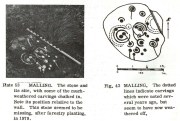
Ron Morris’ sketch & photo

When Alison Young (1938) came to write about the carving, she echoed Hutchison’s thought that the stone might originally have covered a tomb—but we simply don’t know and it should be treated as guesswork, as there are no known prehistoric tombs anywhere hereby.
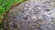
Close-up of faded cups

Years passed before the next archaeological visit – by which time the stone had been uprooted and moved, apparently “ploughed up by the Forestry Commission”, and when Ron Morris (1981) last sought it out found that “the stone was un-traceable”.  On a previous visit, before being moved, he found it to be,

“a cup-and-three-rings, 3 cups surrounded by two rings…and 6 cup-and-one-ring.  One of these and 2 cups form part of the design of the cup-and-three-rings.  There were also at least 7 other cups, and a number of grooves, some forming lines from a central cup, or a cup-mark, downhill.  Greatest diameter visible in 1977 30cm (12in) and depth of carving 3cm (1 in)… Many of the carvings are so weathered as to be visible only when wet in early morning or late evening.”

And when we visited the site a few days ago, the stunning sunlight that had followed us all day, sadly faded and disallowed us better photographs of the site.  Huge apologies…. But it’s worth visiting when the daylight’s good, perhaps when you’re exploring the huge number of brilliant petroglyphs at Ballochraggan and Nether Glenny on the hillside 1½ miles immediately north of this “outlier”, as Brouwer & van Veen (2009) called it.

Folklore

In a landscape bedevilled with stunning petroglyphs, traditions and folklore of them is all but gone; but the story of the Peace Stone was thankfully captured in words by Mr Dun (1866), who told us:

There is a curious prophecy connected with a stone situated near the ruins of the chapel of Arnchly, and which is worth recording.  From time immemorial this stone went under the name of the Peace Stone, and it was held in great reverence by the natives.  One Pharic McPharic, a noted Gaelic prophet, foretold that, in the course of time, this stone would be buried underground by two brothers, who, for their indiscretion, were to die childless. By-and-by the stone would rise to the surface, and by the time it was fairly above ground, a battle was to be fought on “Auchveity,” that is, “Betty’s Field.”  The battle was to be long and fierce, until “Gramoch-Cam” of Glenny, that is, “Graham of the one eye,” would sweep from the “Bay-wood” with his clan and decide the contest. After the battle, a large raven was to alight on the stone and drink the blood of the fallen. So much for the prophecy then; now for the fulfilment. About fifty years ago, two brothers (tenants of the farm of Arnchly), finding that the stone interfered with their agricultural labours, made a large trench, and had it put several feet below the surface. Very singular, indeed, both these men, although married, died without leaving any issue. With the labouring of the field for a number of years, the stone has actually made its appearance above ground, and there is at present living a descendant of the Grahams of Glenny who is blind of one eye, and the ravens are daily hovering over the devoted field. Tremble ye natives! and rivals of the “Hero Grahams,” keep an eye on Gramoch-Cam!

The name of Betty’s Field came from an earlier piece of folklore: where a prince out hunting a stag was caught in one of the deep bogs hereby, only to be rescued by a local lass.  In return for her help, she was given a large piece of land which was to bear her name.

References:

  1. Armit, Ian, “The Peace Stone (Port of Menteith parish),” in Discovery & Excavation Scotland, 1998.
  2. Brouwer, Jan & van Veen, Gus, Rock Art in the Menteith Hills, BRAC 2009.
  3. Dun, P., Summer at the Lake of Monteith, James Hedderwick: Glasgow 1866.
  4. Hutchison, A.F., “The Standing Stones and other Rude Monuments of Stirling District,” in Transactions Stirling Natural History & Antiquarian Society, volume 15, 1893.
  5. Hutchison, A.F., The Lake of Menteith: Its Islands and Vicinity with Historical Accounts of the Priory of Inchmahome and the Earldom of Menteith, Stirling 1899.
  6. Mallery, Garrick, “Pictographs of the North American Indians,” in Bureau of Ethnology of the Smithsonian Institution, volume 4, 1886.
  7. Morris, Ronald W.B., The Prehistoric Rock Art of Southern Scotland, BAR: Oxford 1981.
  8. van Hoek, Maarten, “Menteith (Port of Menteith parish) Rock Art Sites,” in Discovery Excavation Scotland, 1989.
  9. Young, Alison, “Cup-and ring Markings on Craig Ruenshin, with some Comparative Notes”, in Proceedings Society Antiquaries Scotland, vol. 72, 1938.

© Paul BennettThe Northern Antiquarian


Montalt, Dunning, Perthshire

Cup-Marked Stone:  OS Grid Reference – NO 06 13

Also Known as:

  1. Canmore ID 26675
  2. Mount Alt Farm

Archaeology & History

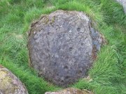
Montalt’s curious cup-marked stone

This is a curious stone and may not be the type of ‘cup-marked’ rock we’re used to.  Maybe… It is presently housed in Stirling’s Smith Art Gallery & Museum, where a small note tells that is was originally found “on the top of the Ochils, near Mount Alt Farm, Path of Condie in 1893.”  The stone was found at the same time, and adjacent to, a prehistoric collared urn—which implies it had an association with a cairn or cist, or burial site of some sort (which isn’t uncommon).  However, the exact location of its original whereabouts has been forgotten.

Broken off from a larger piece of stone, the remaining piece of rock has six cup-markings cut into it, between one and three inches across.  The smallest cup is what we might call a ‘normal’ size, but the rest of them get increasingly large and may have been more functional than purely mythic in nature.  In a small note attached to the stone in the Museum, they add the interesting note that,

“There are…indications that in some places they may be related to transhumance: the practice of moving sheep, cattle and goats to higher pastures in the summer, where they may have been used to mark routes or sources of water.”

They may indeed – amongst a variety of other things too.  But the suggested relationship with cattle occurs in stones found near Haworth, West Yorkshire, where large man-affected carved ‘cups’ such as the ones here, were known to be filled with milk at specific times of Nature’s calendrical rhythms, for the spirits of the place to give good fortune to the farmer and local people.  We know of one instance where this practice still occurs and goes back generations in the same family.  Examples of this animistic practice have also been found in the Scottish Highlands.

© Paul BennettThe Northern Antiquarian


Gawk Hall Stone, Middleton Moor, North Yorkshire

Cup-Marked Stone:  OS Grid Reference – SE 13004 53097

Getting Here

Gawk Hall Stone

Probably the easiest route to find this is via the Roman Road from Blubberhouses. Go up Cooper Lane a few hundred yards, turning right (west) on the footpath past the Manor House and onto the moor. Walk along the footpath until you hit the dead straight Roman Road and walk 1⅓ miles (past the cup-marked Eagle Stone) until you meet another footpath on your right veering over the haunted Sug Marsh away from the straight road. This takes you to Gawk Hill Gate ½-mile away. Go over the wall here and walk for 350 yards where several stones are just yards to the left of the path. You’re there!

Archaeology & History

…and again!

Depending on the age of the old path by which this carving lies, it may have represented a marker of the ancient route.  It lives in relative isolation from other petroglyphs a mile or so further down the moorland slopes and is probably one only for the purists amongst you.  A smoothed (female) medium-sized rock, about 2 yards by 1 yard across, possesses at least two simple cup-marks on its upper western surface. A third cup seems evident between the main two cups, with a carved line running some 10 inches towards the eastern side of the stone.  What may be several other cup-marks can be seen on the stone, but the day was overcast when we came here and so we’re unsure as to whether they’re natural or man-made.

Acknowledgements:  Many thanks to James Elkington and his little compatriot Mackenzie, who accompanied us to this and other sites nearby.

© Paul BennettThe Northern Antiquarian


Langside House, Cathcart, Glasgow, Lanarkshire

Cup-and-Ring Stone (removed):  OS Grid Reference – NS 5726 6128

Also Known as:

  1. Bluebell Woods
  2. Canmore ID 44291
  3. Langside Stone

Archaeology & History

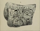
The Langside House, or Bluebell Woods carving

Amidst where now the busy city spreads on the south-side of Glasgow, there was once an excellent multi-ringed prehistoric petroglyph to be seen.  According to the official records, it was all alone – but I don’t buy that for one minute! (petroglyphs rarely occur in isolation)  However, it looks as if this might have been the last of its kind in the area, betwixt where now large houses grow in the landscape of Langside and Battlefield, a few hundred yards south of the hillfort-topped Queen’s Park.

Before being noticed by archaeologists, the stone was apparently being used as a stone seat in the woods for people to sit on!  It was probably a part of a larger monument, perhaps a cairn of some sort.  Certainly from the sketches we have of it, it was part of a larger piece of stone and was likely to have had companions, but records seem to be silent on the matter. The most detailed description of it comes from the pen of northern antiquarian Fred Coles (1906), who gave us the following literary portrait:

“The first notice of the Stone incised with the design shown below was due to Mr W. A. Donnelly, who contributed a description and a sketch to The Glasgow Evening Times of 25th June 1902.  Later, Mr Ludovic Mann, at my request, sent me certain notes he had taken of the cup-and-ring-marks.  But prior to this, the Stone itself had, on the instigation of Mr Donnelly, I think, been removed from its site in the wood, and placed near one of the entrances to the new Kelvinside Museum.  There I saw it and made measurements in July 1903.

“The Bluebell Wood lies in a curving line to the west and south of Langside House, and the cup-marked Stone was at a point in the southern extremity of the wood, above and north of the river Cart.  It is interesting to be able also to record that the longer axis of the Stone lay almost precisely north and South, and the opposite axis east and west.*  The Stone is of a hard, whitish sandstone, a good deal weathered and rounded at the edges. It measures 4 feet 9 inches in length and 3 feet 2 inches in breadth, and varies in thickness from 2 feet 6 inches to 1 foot 7 inches.  The striation of the Stone has helped to efface the cuttings which, though perfectly clear and measurable, are shallow in proportion to their width.  And this feature I have endeavoured to portray in the accompanying illustration (above).  Beginning at the north end of the Stone, there is one cup placed just where the outermost ring of that group touches the edge of the Stone.  The ring has a groove leading towards but not into a central cup, and four other cups are placed on the two outermost rings, there being four rings in this group.  The middle group consists of a central cup and three rings, flanked on the west by a row of three cups (one of which is the largest of all), and on the east by a double row of six cups, three of which are almost obliterated.  This middle group is imperfectly concentric, two of its arcs running into the fourth ring of the group on the south, which has a fine deeply picked central cup.  All the better-preserved rings are very nearly 1½ inches in width of cutting.

“The diameters of the outermost rings in each group are: of the north group, 1 foot 9 inches; of the middle group 1 foot 5 inches; and of the south group 1 foot 7 inches.  The cups vary in diameter from 3 inches to 1½.

“Considering the extremely easily weathered nature of this Stone, and the fact that its sculptured surface has already suffered much ill-usage, its present position, near the entrance of the Art Galleries, entirely unprotected by a railing and exposed to all sorts of abuse by casual passers-by as well as the weather, is not a fit and proper place for a Stone of such interest.”

A few years after this, the local historian Ludovic MacLellan Mann (1930) wrote a piece for the Glasgow Herald, in which he thought that both this and another carving in the area,

“commemorate chiefly…an eclipse of the sun seen in Glasgow district in the year 2983 BC, at three o’ clock in the afternoon of the sixth day after the Spring Equinox.”

A fascinating idea…  Mann was intrigued by the theory that petroglyphs represented astronomical events or maps of the skies – and we know from cultures elsewhere in the world that some carvings had such a function; but it’s not integral to all carvings by any means.

The stone was included in Ron Morris’ (1981) survey, merely echoing the description of Fred Coles, adding nothing more.  And so it seems that the carving is still in the museum somewhere.  Canmore has it listed as “Accession no: 02-78”.  Does anyone know of its present situation?  Can anyone get a photo so we can give it a more fitting site profile?  It looked a damn good carving!  And, if anyone lives nearby, I note that there are small patches of the old woodland still visible on GoogleEarth: therein, perhaps, a diligent explorer may just find another carving….

References:

  1. Coles, Fred, “Notices of Standing Stones, Cists and Hitherto Unrecorded Cup-and-Ring Marks in Various Localities,” in Proceedings of the Society of Antiquaries, Scotland, volume 40, Edinburgh 1906.
  2. Donnelly, W.A., “Letter”, Glasgow Evening Times, 25 June, 1902.
  3. Mann, Ludovic MacLellan, “The Eclipse in 2983 B.C. – Discovery near Glasgow,” in Glasgow Herald, 17.09.1930.
  4. Morris, Ronald W.B., “The Cup-and-Ring Marks and Similar Sculptures of South-West Scotland,” in Transactions of the Ancient Monuments Society, volume 14, 1967.
  5. Morris, Ronald W.B., The Prehistoric Rock Art of Southern Scotland, BAR: Oxford 1981.
  6. Morris, Ronald W.B. & Bailey, Douglas C., “The Cup-and-Ring Marks and Similar Sculptures of Southwestern Scotland: A Survey,” in Proceedings of the Society of Antiquaries, Scotland, volume 98, 1966.
  7. Small, Sam, Greater Glasgow: An Illustrated Architectural Guide, RIAS: Edinburgh 2008.

ACKNOWLEDGEMENTS:  Huge thanks to beautiful Aisha for putting me up.

* Although Coles did note how its earlier use as a stone seat probably negates his axial measurements.

© Paul BennettThe Northern Antiquarian