Take the same directions as if you’re visiting the Rivock Edge 060 Carving. It’s 25 yards NNW – you can’t really miss it!
Archaeology & History
Rivock Edge, carving 58
This large flat rock, with a couple of long lines almost splitting the rock into sections, was first mentioned as a prehistoric site in John Hedges (1986) survey, where he described it simply as, “Large rough grit rock with possible four cups, in crowberry.” Boughey & Vickerman (2003) said even less about it! One of the cups is very distinct, but the others are somewhat faded and perhaps even dubious. It’s still worth a look at, if only due to the other better carvings nearby.
References:
Bennett, Paul, “The Prehistoric Rock Art and Megalithic Remains of Rivock & District (parts 1 & 2),” in Earth, 3-4, 1986.
Boughey, Keith & Vickerman, E.A., Prehistoric Rock Art of the West Riding, WYAS 2003.
Hedges, John (ed.), The Carved Rocks on Rombald’s Moor, WYMCC: Wakefield 1986.
Takes a bitta finding unless you’ve got a GPS system, or someone like me to show you where it is! The best way’s probably via the Askwith Moor Road car park, up the road 160 yards till you hit the straight line cut into the moor on your right, where the landscape’s been damaged.* Walk along this for less than 100 yards, then walk right, through the heather and onto the singular tree roughly 200 yards away. From here, walk 75 yards (strides) north from the tree. You’re damn close!
Archaeology & History
About 20 feet from a line of ancient walling in an area pretty rich in prehistoric sites, is this medium-sized stone with a lovely cup-and-ring design. The carving was first recorded by fellow antiquarian, Eric Cowling (1937), in his short survey of other carved stones in the area. He called this ‘carving no.7’ and described it, thus:
“In the central area of Snowden Carr is a barrow group, which occupies a slight ridge running from the edge of the bog to the east, almost to the moor road on the west. The ridge is almost devoid of vegetation except at the higher end. Here, on a heather-covered boulder, is marking no.7. The cups are smaller than usual, and only one ring completely surrounds a cup. The lines linking the cups are only lightly incised, and the whole marking has a delicate appearance.”
Old photo of the carvingCowling’s 1937 drawing
I first visited this stone in the 1980s with fellow rock art student and author, Graeme Chappell, and for some reason it has always impressed me (I recall Graeme laughing whilst I made joyous noises and stroked the rock, reverentially!). Cowling’s description of the stone as ‘delicate’ is appealing, as the stone and its design has a nurturing aspect to it, female in nature. (forgive me — but many of these stones tend to capture me in such ways!) The stone was described more clinically in Boughey & Vickerman’s (2003) more recent survey as follows:
“Fairly large, flat, smooth grit rock with crack. Up to seventeen possible cups, one with complete ring, one with partial ring, one with possible ring; connecting groove.”
Doesn’t quite capture the feel of the place, which I’m sure they’d admit. The next time I’m up here, I’ll get some better photos of the carving.
References:
Boughey, Keith & Vickerman, E.A., Prehistoric Rock Art of the West Riding, WYAS 2003.
Cowling, E.T., ‘A Classification of West Yorkshire Cup and Ring Stones,’ in Yorkshire Archaeological Journal 1940.
Cowling, E.T., Rombald’s Way: A Prehistory of Mid-Wharfedale, William Walker: Otley 1946.
Cowling, E.T. & Hartley, C.A., ‘Cup and Ring Markings to the North of Otley,’ in Yorkshire Archaeological Journal 33, 1937.
ACKNOWLEDGEMENTS: Huge thanks to one of my fine ladies, Inmaculada Ibanez-Sanchez, for the drawing! Cheers Inma!
* A pipeline was laid across the moor here, and subsequent work (I presume by the same company) was done again in early 2011, cutting through and damaging several prehistoric monuments and destroying at least one prehistoric cairn. An archaeological survey of the region should have been done before any work proceeded here, but I’m unaware of any such excavations, or archaeological reports preceding or concurrent to the ecological and historical damage performed.
Follow the same directions as if you’re going to the excellent Morphing Stone cup-and-ring carving. From the carving, look up the field to the where the dirt-track is and, by the closest gate with a tree near it, walk straight towards it. Roughly halfway between the Morphing Stone and the gate you’ll find — eventually — the small stone in the photo with well-defined cups on it. You might need to wander back and forth until you find it, as there’s many rocks to check out here!
Archaeology & History
Possible cup-marked rock
This small cup-marked stone was rediscovered by Danny Tiernan in the late afternoon of Thursday, August 18, 2011, just as the heavens opened and the rains poured down! With at least one well-defined cup-mark and another two near the edge of the stone where the grasses had grown, this stone probably needs another look at it, as there may be more beneath the surface, much like when we first found at Morphing Stone.
Danny also found and photographed another larger boulder, a bit further up the field closer to the fence, where what may be a single cup-mark is clearly seen living on top of the rock. It’s one of those dodgy English Heritage ones though, so I’ll let those ‘qualified’ chaps check this one out and give it their expertise! It could well be another unrecorded cup-marked stone though…
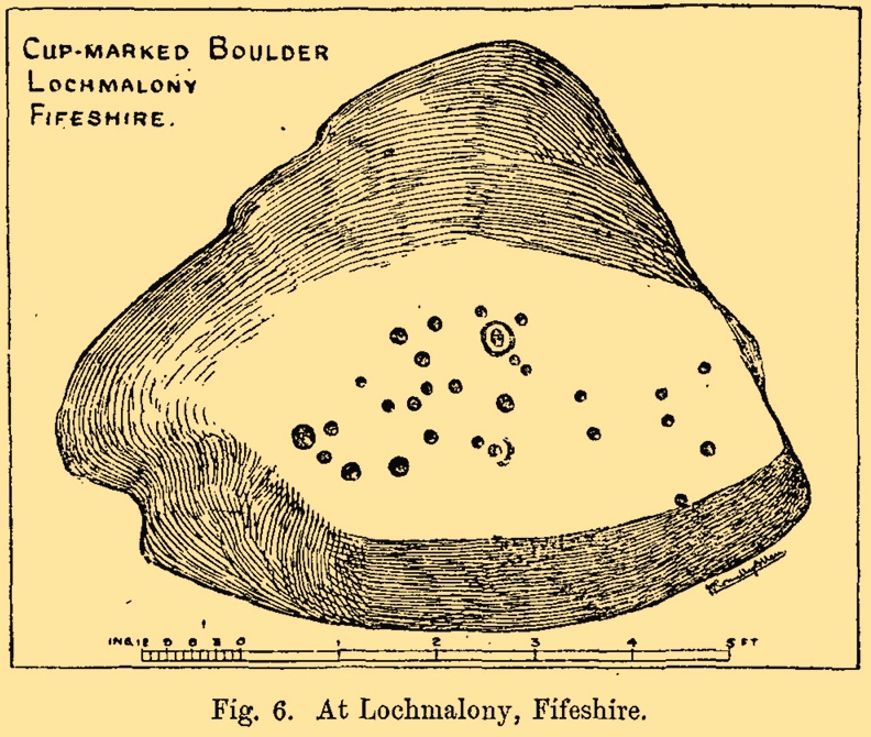
Cup-and-Ring Stone (destroyed): OS Grid Reference – NO 379 204
Archaeology & History
J.R. Allen’s 1882 sketch
Here’s another old carving that has succumbed to the lack of animistic respect endemic in modern culture. Ronald Morris (1981) reported that this carved rounded boulder was “dynamited by the farmer and (is) now no longer extant.” First described in 1882 and later included in the Fife Inventory (1935), the large smooth rock used to lay within a nice copse of dense gorse, measuring 2½m x 1¾m across and about 1m high from ground level.
It was uncovered in 1872 and mentioned briefly for the first time in Arthur Mitchell’s (1874) fine essay on the antiquities of Cromar, where he told that “Dr. Batty Tuke tells me there is a cup stone on a moor forming part of Lochmalonie farm, in the parish of Logie, Fifeshire.” His notes were followed up by the great Romilly Allen (1882), whose sketch is all that remains of this ancient site. The carving was subsequently included in one of Ron Morris’s (1981) survey of Scottish petroglyphs, describing it simply as,
“2 cups-and-one-complete ring (one mostly weathered off), diameters 10cm (4in) and 27 cups (carving depth and angle of slope not now known.”
Its isolation from any other known petroglyphs is a little odd and there is every possibility is accompanied a prehistoric burial of some sort; although from the attitude of the farmer, all trace of that would have gone too. On a more positive note, when Batty Tuke spoke with Romilly Allen about this carving, he told that he has “frequently noticed well-marked cups on dry stone dykes in the Glenduckie area.” Petroglyph explorers amongst you might want to spend some time meandering in this neck o’ the woods….
Morris, Ronald W.B., The Prehistoric Rock Art of Southern Scotland, BAR: Oxford 1981.
Royal Commission on Ancient & Historical Monuments, Scotland, Eleventh Report with Inventory of Monuments and Constructions in the Counties of Fife, Kinross and Clackmannan, HMSO: Edinburgh 1935.
Ornate cup-and-ring in Queens Wood (after RCAHMS 2004)
From Kenmore, take the road towards Acharn on the south-side of Loch Tay for about a mile. Just as you go out of Acharn, watch for the small road of Queens Drive on your left going uphill. Go up here, following the tree-lined burn (stream) towards the superb Falls of Acharn, crossing the track over it and winding uphill still, until the track veers left across open fields towards the large woodland 400 yards east. Just before the track meets the trees, notice the small burn running into the woods. Follow this for some 200 yards – and where it bends more sharply to go uphill, keep going for another 75 yards upstream until you meet with another opening going east. The rocky outcrop here is where this carved stone is found. Look around!
Archaeology & History
Hidden deep within the woods where wet feet and good ankles come together, is this fine example of a cup-and-ring stone, perhaps having something in times of olde to do with the meeting of the waters. A cluster of urisks and prehistoric remains scatter this lovely rolling section of southern Loch Tay, but I’ve found nothing specific to this bitta woodland that might give added mythos to the site. The carving was described in Mr Stark’s (2005) fine little work on the local rock art, saying:
“A rock outcrop, situated in woodland between Acharn Burn and the burn running down to Remony House, bears at least thirty-six cupmarkings. There are twenty-four plain cups, three cups each with a single ring, three cups each with double rings, and a cup surrounded by three faint rings, which has a gutter leading to the NW. The cups range from 40mm to 75mm in diameter and from 60mm to 120mm in depth.”
The next time we visit the place, I’ll make sure I get some good photos – and visit the stone circle and settlement a few hundred yards further up the hill…
References:
Stark, Gordon (ed.), Cupmarked Stones in Strathtay, Breadalbane Heritage Centre 2005.
At the pub by the bridge which crosses the Falls of Dochart (aptly called the ‘Falls of Dochart Inn’), walk downstream following the dirt-track which runs parallel with a section of the river for a good 5-600 yards. In the field that appears on your right, watch out for the rise of the stones as you approach the large gates which take you into the ground of Kinnell House. You can climb over the gate just into the field and go straight to the stones.
Archaeology & History
Found on the field called Kinnell Park in the grounds of Kinnell House, less than a mile out of Killin, this is a well-preserved site consisting of six stones. It appears to have been described first of all by Thomas Pennant in 1772, in the same breath as the megalithic remains at Lawers on the other side of Loch Tay. Pennant wrote:
“In going through Laurs observe a Druidical circle; less complete indeed than one, that should have been mentioned before, at Kinnel, a little southwest of Killin; which consists of six vast stones, placed equidistant from each other.”
Coles’ 1910 plan of KinnellThom’s geometric plan
It would seem that the site has changed little since Pennant’s visit. Sitting on a reasonably level grassy plain, the hills rise and surround the small ring of stones, with the lower horizons running along the south. Due west (equinox) we have the large pyramidal hill of Meall Clachach; whilst to the north are the legendary hills of Creag na Cailleach and Ben Lawers, each with their own rich mythic archaeological legacies. Legendary stones and wells are also close by, some with rites still enacted by old local people keeping truly ancient traditions alive.
The first detailed archaeological survey of the Kinnell site was done by Fred Coles and published in 1910. It has yet to be superseded. Mr Coles wrote:
“Taking the Stones in the usual order…I here give their dimensions and characteristics: Stone A, 6 feet 3 inches high, springs from an oblong base which girths 11 feet 4 inches, to a rough irregular top; Stone B leans forward towards the centre of the Circle, and measures along its sloping back 6 feet 9 inches, the present height from the ground to its upper edge being 4 feet. It is of smooth garnetiferous schist, and free from the deep fissures and rifts so common in these Stones. Stone C, a very rectangular but narrow block of schist, has a 15 Feet-girth at the base of 9 feet, but tapers up from both ends to a pyramidal summit, 5 feet 4 inches above ground. Its inner face is over 6 feet in breadth. Stone D, 4 feet 6 inches high, is a broad, flat-topped, very massive block, measuring 9 feet 5 inches round the base, but near the middle of its height 11 feet 2 inches. Stone E, the shortest of the group, is only 4 feet high, has a rough, uneven top, and a basal girth of 8 feet 11 inches. Stone F, the tallest, measures 6 feet 4 inches in height, but in girth only 7 feet 3 inches. It is very rough, vertically fissured in many places, and full of white quartz veins.
“Neat, well-defined, and comparatively small as this Circle is, it is to be noticed that the positions of the Stones do not conform to perfect regularity as points on the circumference. On working out the plan, the measurements prove that a diameter of 29 feet exactly bisects three of the erect Stones, B, C, and F, but leaves the other two untouched. The interspaces of the settings are not all quite equal, a space of 14 feet 8 inches dividing the centres respectively of F and A, A and B, F and E, and E and T); but between D and C it is 13 feet 8 inches, and between 0 and B I S feet 5 inches. Yet, the Stones stand proportionally near enough to each other to give one a satisfying impression that these six megaliths represent the group in its completeness, and that there were no smaller blocks between any two of them. The space enclosed by these stones is quite smooth and level, bearing no indication of having at any time been disturbed.”
Many years later, the late great Alexander Thom came here and, with his geometric perspective, gave a more precise ground-plan and lay-out. Thom (1980) defined the site as a “Type B flattened circle, or possible ellipse,” with a perimeter of 35 megalithic yards and diameter of 11.8 MY. Aubrey Burl’s commentary described Kinnell as:
“Six stones of schist stand evenly spaced on the circumference of an ellipse 32ft 7in x 27ft 5in (9.9 x 8.4m) in diameter. The stones are graded in height towards the SW where the two tallest are over 6ft (1.8m) high.”
One of the upright stones was said by Hugh MacMillan (1884) to have had cup-markings on it in the 19th century, when he told of the circle possessing “some seven or eight tall massive stones, with a few faint cup-marks on one of them.” But these appear to have faded, or were cut into the one of the missing stones.
Folklore
Close to the Kinnell circle could once be found a curious large boulder, covered in moss, but with a large cavity in which water gathered. Local lore ascribed the rock to actually be a well, as it was known as ‘The Well of the Whooping-Cough’, or Fuaran na Druidh Chasad, measuring some eight feet long and five feet high. Local people visited the site to be cured of the said disease, but Hugh MacMillan also suggested that the miraculous well-in-the-stone was connected with ancient rituals once enacted at the Kinnell circle, saying:
” it is a reasonable supposition that the Fountain of the Whooping-Cough may have had some connection in ancient times with this prehistoric structure in its immediate neighbourhood…”
He may have been right!
…to be continued…
References:
Burl, Aubrey, A Guide to the Stone Circles of Britain, Ireland and Brittany, New Haven & London 1995.
Pennant, Thomas, A Tour in Scotland, 1772 – Part 2, Benjamin White: London 1776.
Royal Commission on the Ancient & Historical Monuments of Scotland, Archaeological Sites and Monuments of Stirling District, Central Region, Society of Antiquaries of Scotland 1979.
Thom, A., Thom, A.S. & Burl, H.A.W., Megalithic Rings, BAR: Oxford 1980.
Wheater, Hilary, Killin to Glencoe, Appin Publications: Aberfeldy 1982.
On the A657 road, a half-mile past Greengates towards Calverley, just before the road starts going uphill, take the lower dirt-track of Eleanor Drive on your left into Calverley Woods (here known as West Woods). About 150 yards along the track, note the small footpath on the right which goes up diagonally further into the trees. Go along here until you reach the remains of a dried-up pond on your left. The carved stone is about 10 yards before the pond, just above the footpath.
Archaeology & History
Rubbing of the 2 cupmarks
Another stone only for the puritans amongst you! This (and the West Woods 2 carving) was one we found in 1985 when we were exploring the woods looking for the Calverley Woods cup-marked stone reported by Sid Jackson in the 1950s. The stone is a small roughly oblong, earthfast rock, about 2ft by 1ft across, and has two distinct but faded cup-marks on its slightly sloping face. That’s it!
Soon after first finding this, we made a couple or rubbings of the stone, one of which I reproduce here and which shows the two cup-marks. You’ll note the measurement and note of the cups being 2 megalithic inches (MI) in diameter. The MI was a statistical unit of measure suggested by the late great Alexander Thom, who found regular integers of 2.07cm in many of the cup-and-rings he examined, and so surmised it as a deliberate numeric system. At the time when we found this cup-marked stone, I was exploring Thom’s idea and was very much taken up with it. However, after a few years doings numerous rubbings of the many cup-and-ring stones in West Yorkshire, and exploring the simple size of the human hand and how we execute cup-markings on rocks, I found Thom’s idea didn’t seem to be realistic. (though I still love Thom’s works: the man was an outstanding researcher, far exceeding all the archaeologists of his period in terms of his exploratory methods)
References:
Bennett, Paul, “The Undiscovered Old Stones of Calverley Woods,” in Earth 2, 1986.
Cup-and-Ring Stone: OS Grid Reference – SO 9875 2825
Archaeology & History
Nottingham Hill cup-and-ring
A rare find this! In October 1981, in deepest Gloucestershire on the edge of the Nottingham Hill Iron Age hillfort, archaeologists sifting through what they ostensibly called “occupational debris” along the western edge of the huge enclosed monument, found a singular piece of local oolitic limestone etched with an archetypal cup-and-ring design! The carving was on a typical ‘portable’ piece of stone and would not have been amiss had it been uncovered in a neolithic or Bronze Age cairn in our more northern climes. But this southern example is something of an anomaly.
In Morris & Marshall’s (1983) description of the stone they told how,
“it was found as a loose block lying with the worked surface uppermost, and half-embedded in the plough-soil, together with other slabs and irregular lumps of oolitic limestone of similar size, and of closely related rock-type. The object is a discreet slab with an unworked under-surface weathered by percolation of ground-water along a joint.”
Drawing of the carving
They found that the carved stone was typical of other rocks making up the ramparts at the outer-edges of the hillfort, and at some point in its history may possibly having been included in the walled structures of the fortress itself. However, this is unlikely to have been the original use of the carving. Its inclusion in the Iron Age ramparts would more be a likely consequence of it being appropriated from another, much earlier archaeological site in the area — a chambered tomb or long barrow for example. This re-use of cup-marked stones in the Cotswolds is known to have occurred in the village of Salford, on the church cross-base, 18.75 miles (30.2km) east of here.
The Nottingham Hill cup-and-ring was described in some detail by Morris & Marshall (1983). The rock on which it was carved measured one square-foot in size and barely 3 inches thick. The central cup-mark measured,
“approximately 15.5cm in diameter, and a shallow radial groove (channel 1) leads from it to the edge of the stone. The central cup-mark is surrounded close to its lip by a penannular channel or ‘ring’ (channel 2), which has a small depression at one end. This end of channel 2 appears to be discontinuous with channel 1, but there is a very lightly pecked connection at the other end. Outside channel 2 is a second shallower ring or channel (channel 3) but because of its shallowness it is difficult to determine whether it links with the radial channel 1. Channel 3 contains a clear, small cup-mark part-way along its length, and is quite definite on one side of the central cup-mark, and on the other side it is possibly mirrored by a rather indistinct depression or cup-mark and length of channel. Channel 3 is not continuous throughout its length, ending where it meets the edge of the stone beyond the small cup-marks.”
It is obvious that the carving, whenever it was made, was not subjected to long-term exposure to the outside air, as the carved design would have eroded quite quickly on the oolitic limestone.
Royal Commission on Historical Monuments, England, Ancient and Historical Monuments in the County of Gloucester: Volume 1 – Iron Age and Romano-British Monuments in the Gloucestershire Cotswolds, HMSO: London 1976.
Cup-Marked Stone (lost): OS Grid Reference – ST 260 870
Archaeology & History
Rhiwderin cup-marks
This fine-looking cup-marked stone was uncovered during a botanical outing in the last decade of the 19th century. Described as being around the township of Rhiwderin, the exact whereabouts of the carving is unknown and it’s not been seen since the first description of it in an early edition of Archaeologia Cambrensis by Mr T.H. Thomas. (1895) John Sharkey (2004) mentioned the site in his recent survey of Welsh rock art, saying simply “location unknown.”
The missing Rhiwderin stone
Although we know there are no hard and fast rules for working out the location of cup-and-ring markings, one may be fortuitous in exploring any nearby Bronze Age or neolithic tombs (cairns, tumuli, etc) in the Rhiwderin district, as they do tend to enjoy the company of such sites — but I must stress, this is by no means a dead cert!
Mr Thomas’s description of the carving was as follows:
“I enclose a sketch of what seems to be a cup-marked stone which I observed yesterday near Rhiwderin, Monmouth. Unless there be some operation which simulates such markings with which I am unacquainted, I take the specimen to add an instance of these mysterious prehistoric remains to the very short list given for Wales by Mr. Romilly Allen, and to be the first reported for South Wales.
“The stone displaying the cup-markings is a mass of millstone grit, earth-fast, the slanting surface appearing above the turf being about a yard wide, and 4 feet long. Upon the upper half of the surface is a group of twelve cups from 1½ to 2in diameter, and about 1in deep. On first noticing the cups they were taken for holes out of which quartz pebbles, abundant in the local millstone grit, had been weathered, but examination of the block showed that no pebbles of large size exist, or had existed in it, and the conclusion was arrived at that the cups are artificial.
“On turning back some of the turf covering the base of the slope of the stone, no other cups were discovered.
“The stone lies within an old enclosure, as shown by wild apple-trees and an abundance of daffodils, and still more clearly by ruins, which seem those of a cottage or small farm near by. This contiguity to a habitation which does not seem to have been abandoned more than a century, made me suspect some medieval or more recent origin for the markings. I cannot, however, account for them otherwise than by supposing them to be cup-markings in the technical archaeological sense.
“The stone was observed while in the company of Dr C.T. Vachell of Cardiff, searching for varieties of narcissus which occur at several points in the neighbourhood…”
If anyone comes across this lost carving, please let us know!
References:
Sharkey, John, The Meeting of the Tracks: Rock Art in Ancient Wales, Gwasg Carreg Gwalch: Llanrwst 2004.
Thomas, T.H., ‘Archaeological Notes and Queries,’ in Archaeologia Cambrensis, volume 12 (5th series), 1895.
Cup-Marked Stone: OS Grid Reference – ST 9583 0294
Also Known as
Badbury Rings Carving
Shapwick 6a carving
Archaeology & History
Badbury Barrow carving (after J.F.S. Stone 1958)
Amidst what was once a veritable gathering of prehistoric tombs on the ground immediately west of the Badbury Rings hillfort — a small necropolis no less! — one particular tumulus which Leslie Grinsell named as ‘Shapwick 6a‘ was in the process of being destroyed at the end of October, 1845, but was fortunate in receiving the quick attention of a local historian called John Austen, who gave us the first known account of the place. (a fuller profile of the Badbury Barrow can be found here) Inside the churned-up remains of Badbury Barrow, which measured 62 feet across and 9 feet high, Mr Austin found a fascinating number of urns and other remains and, shortly after, this rare example of a petroglyph was identified. The stone now lives in the British Museum where, the last I knew, you could certainly check it out. But it’s not its original size, as sections of the stone were broken off. As Aubrey Burl (1987) told us, the stone was originally about half-a-ton in weight, on which,
“were carvings of five cupmarks, two bronze daggers and two flat, triangular axes of early Breton type.”
Grinsell’s more detailed description of the carving from his work on Dorset Barrows (1959) tells a little more of the design found on this seeming ‘tomb-stone’:
“Sandstone slab, probably from stone cist, decorated with pecked carvings of two daggers with hilts, resembling those on stone 53 at Stonehenge; two triangular objects probably intended to be flat bronze axe-heads expanding at their cutting-edge; and five cup-shaped hollows. The existing decorated fragment (in British Museum) is 1ft 10in long, and was detached from the original slab which weighed probably more than half a ton. The size suggests, perhaps, a cover-slab.”
It may well have been. Certainly it had some relationship to death! The design was suggested in the 19th century to perhaps have been influenced by Greek imagery, when such notions were in vogue. As Grinsell tells,
“In the centre according to Durden…was the well-known large slab of sandstone which was decorated with carvings of daggers and axes, the former of type similar to those from Stonehenge, conjectured to be of Mycenean type.”
But the Mycenean nature of the carvings is highly unlikely. What is intriguing with this carving is the appearance of cup-markings (commonly associated in or adjacent to prehistoric tombs) alongside defined symbols of daggers. We could infer a magickal relationship between the two symbols here: one of which, the cups, comes from a much earlier period than the dagger-design. A more in-depth analysis of the human remains within the tumulus and a plan of the site would perhaps be more revealing…
…to be continued…
References:
Austen, John H., “Archaeological Intelligence,” in Archaeological Journal, volume 3, 1846.
Burl, Aubrey, The Stonehenge People, Guild: London 1987.
Grinsell, Leslie V., Dorset Barrows, Dorset Natural History & Archaeological Society 1959.
Knight, Peter, Ancient Stones of Dorset, Power: Ferndown 1996.
Royal Commission on Historical Monuments, England, An Inventory of the Historical Monuments in the County of Dorset – Volume 5: East Dorset, HMSO: London 1975.
Stone, J.F.S., Wessex Before the Celts, Thames & Hudson: London 1958.
Warne, Charles, The Celtic Tumuli of Dorset, John Russell Smith: London 1866.


")
")


