Take the same directions as if you’re going to Dave’s Stone, to the eastern end of Rivock Edge itself. Then take less than 10 steps further onto the moor itself and you’ll see the stone pretty low down in the heather. (please note that grid-reference above needs revising)
Archaeology & History
…and looking straight down!
Found about 10 yards onto the flat ridge south of Dave’s Stone cup-marked stone, the vegetation covering this carving had only recently been brushed off when we revisited the place in 2012, by members of the Ilkley CSI team in their own survey of the area. As you can see, it’s a simple design of just two well-preserved cups on a small rounded stone. What may be the remains of a very faint ring arc is possible over one of the two cups. Nowt much more to say really!
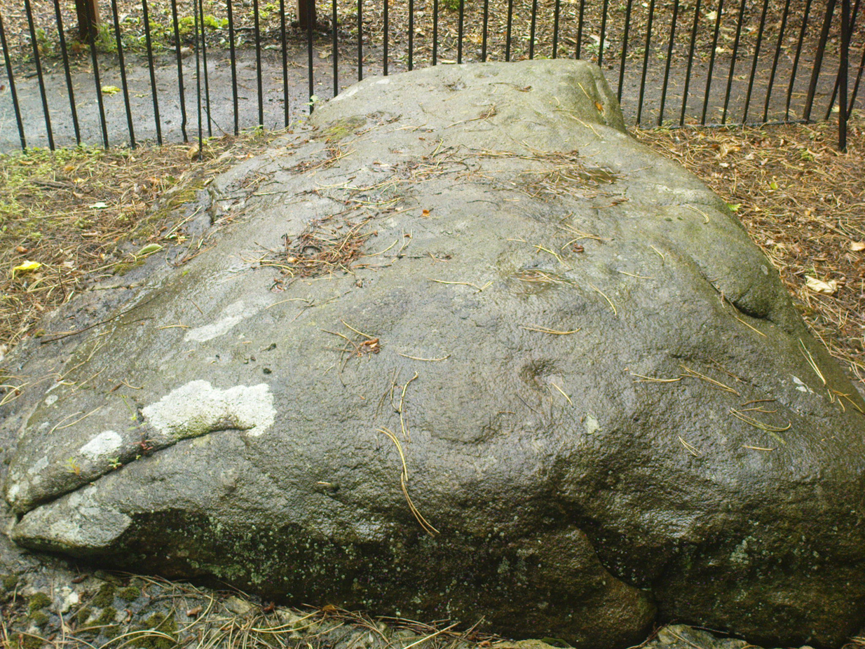
From Cow & Calf Hotel head onto the moor above you, following the same directions to reach the ornately carved Idol Stone (and its immediate companions). Ahead of you on the same footpath, about 100 yards along, as it begins to slope up the hill further onto the moor, you’ll see a large upright pyramid-shaped stone, about 8 feet all, right at the side of the path. Y’ can’t miss it!
Archaeology & History
Deep cups & lines on top
Although ascribed as a cup-marked stone in usual surveys, the cup-markings on top of this rock are seemingly Nature’s handiwork. There is a possibility that cup-markings were carved into the top of the stone, many thousands of years ago, but due to the centuries of wind and weathering, we cannot in anyway assess the curvaceous bowls and lines running across and from the top of this rock to be artificial.
Folklore
The name ‘Idol Stone’ seems to have come about as a result of the judaeo-christian Victorian obsession of satanic idolatry in all things natural – which many of them still fear. Sadly there are no early accounts of practices of idolatry at this rock, until it was used by chaos magickians in the formative years of that Current in the 1980s.
References:
Bennett, Paul, The Old Stones of Elmet, Capall Bann: Milverton 2001.
Boughey, K.J.S. & Vickerman, E.A., Prehistoric Rock Art of the West Riding, WYAS: Leeds 2003.
Forrest, C. & Grainge, William, A Ramble on Rumbald’s Moor, among the Dwellings, Cairns and Circles of the Ancient Britons, W.T. Lamb: Wakefield 1868-9.
Hedges, John (ed), The Carved Rocks on Rombald’s Moor, WYMCC: Wakefield 1986.
Holmes, J., “A Sketch of the Prehistoric Remains of Rombald’s Moor,” in Proceedings of the Yorkshire Geological Society, volume 9, 1887.
Speight, Harry, Upper Wharfedale, Elliott Stock: London 1900.
Cup-marked stone, with Dunruchan C standing stone on horizon
We parked-up by the small trackway into the fields on the opposite side of the road 100 yards short of Craigneich across from the standing stone, then walked up the track, thru the gate, then walked uphill. Tis boggy & bumpy as you’d expect – and then, as you espy the giant standing stones of Dunruchan on the ridges above, watch out for the large rounded boulder (amongst many) as you near the level 100 yards or so before the magnificent Dunruchan A stone. Look around!
Archaeology & History
Close-up of cup-marks
Not far from the cup-marked stones of Blar an Rodhar is what appears to be another such carving. Here, two archetypal cup-marks are clearly visible on one of the large rocks on the slope up to the huge standing stone of Dunruchan A. There may be other faint cup-marks on this boulder, but the light wasn’t too good when we first found this, so I’m not sure about any others. The main two however, as the photo shows, stand out! A grassy overgrown cairn is some 10 yards away to the east, almost in line with the largest Dunruchan Stone. The Dunruchan C standing stone is also clearly visible on the skyline to the west, leaning at an angle. Many other small cairns are scattered on the grassy plain where this cup-marked stone rests. The carving is not included on Canmore’s website, so this could be another new find. However, the rock up here aint what I’m used to – so if any local geologists or antiquarians can show me it’s Nature’s handiwork, please lemme know and I’ll delete it from the website.
* Grid-ref may need revising, as we went out without mapping instruments. If someone gets a better coordinate, please send it in.
From Thackley corner, take the Esholt road down Ainsbury Avenue. Walk past the Thackley football ground and another 50 yards on, to your left, there’s a field. Cross this and go through the gate into the trees. Another field is across the footpath, but turn right and walk on the muddy path, keeping parallel with the other field, until the walling bends round to the left. About 15 yards round where the wall bends left, watch out for the silver birch tree and the small cup-marked rock at its base, right up against the wall.
Archaeology & History
This is an archetypal single cup-marked stone known as a ‘portable’ — though in its original state, when the rock was obviously larger than it is today, I doubt anyone could have carried it further than a couple of yards! The stone has been split from a larger rock, and we’re unsure the size of its original form—but presume it to have been perhaps double its present size.
The broken rock stands (now) upright against the wall and nice birch tree (Betula pendula), but wasn’t like that when we first found it, and the cup was barely visible as it faced down into the Earth. As the images show, we have just a single cup-mark on its outer face. It looks typical of those carvings found in the larger Bronze Age cairns scattering the moors to the north, but we have no evidence nor folklore indicating the existence of such a monument hereby. The extensive amount of overgrown multiperiod walling all over this woodland may have used up such a cairn, but we will probably never find out, as the woods have been overused by industrialists, who are now, slowly, turning the woods here into a park.
From Thackley corner, take the Esholt road down Ainsbury Avenue. After a couple of hundred yards, note the metal gateways into the woods. Go through here, following the main path, until you reach another split in the paths where one of those awful touristy signs tells you where you are. Walk past this (not left or right) into the opening of large oaks and other trees on a flat plain. A path swings round the right side of this, and less than 100 yards along, watch out for some rocks on your right, heading towards the wall and small field. You’re damn close!
Archaeology & History
Close-up of cup-markings
This is one amongst a cluster of at least five cup-marked stones very close to each other in the woods here — and probably the best of the bunch. Also found in conjunction with what seems to be an Iron Age walled enclosure 20 yards away, there are at least eight cup-marks on top of this rock, They occur in two groups: one, on a sloping section of the boulder where three fading cups can be seen; and the other is on the topmost section of the stone, where five larger cups distinctly stand out, and occur in conjunction with what seems to be a long carved line running close to the edge of the rock before it drops sharply to the ground.
This and its associated carvings are found in close proximity to some sort of walled enclosure. It’s difficult ascertaining the age and nature of the enclosure walling, as masses of it are found throughout this section of woodland and it appears to be multiperiod in age and nature: from Iron Age to Victorian by the look of things. Neither this cup-marked stone, nor any of its close associates (the closest of which is the Buck Woods 3 carving, less than 10 yards away), were recorded in the Boughey & Vickerman survey of rock art in West Yorkshire.
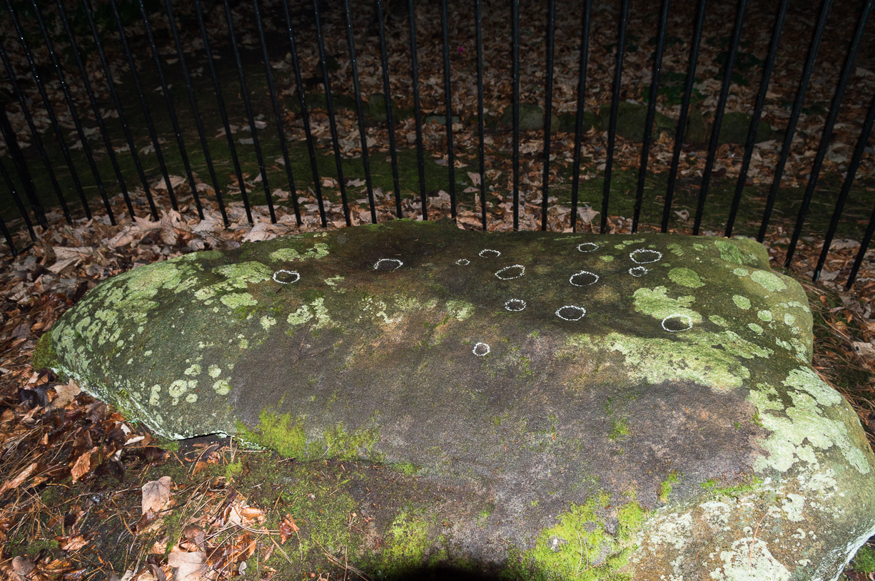
Come out of Ilkley/bus train station and turn right for less than 50 yards, heading left up towards White Wells. Go up here for less than 100 yards, taking your first right and walk 300 yards up Queens Road until you reach the St. Margaret’s church on the left-hand side. On the other side of the road, surrounded by trees is a small enclosed bit with spiky railings with Panorama Stones 227, 228 and 229 all therein: the least-decorated one on the left being the one we’re dealing with here.
Archaeology & History
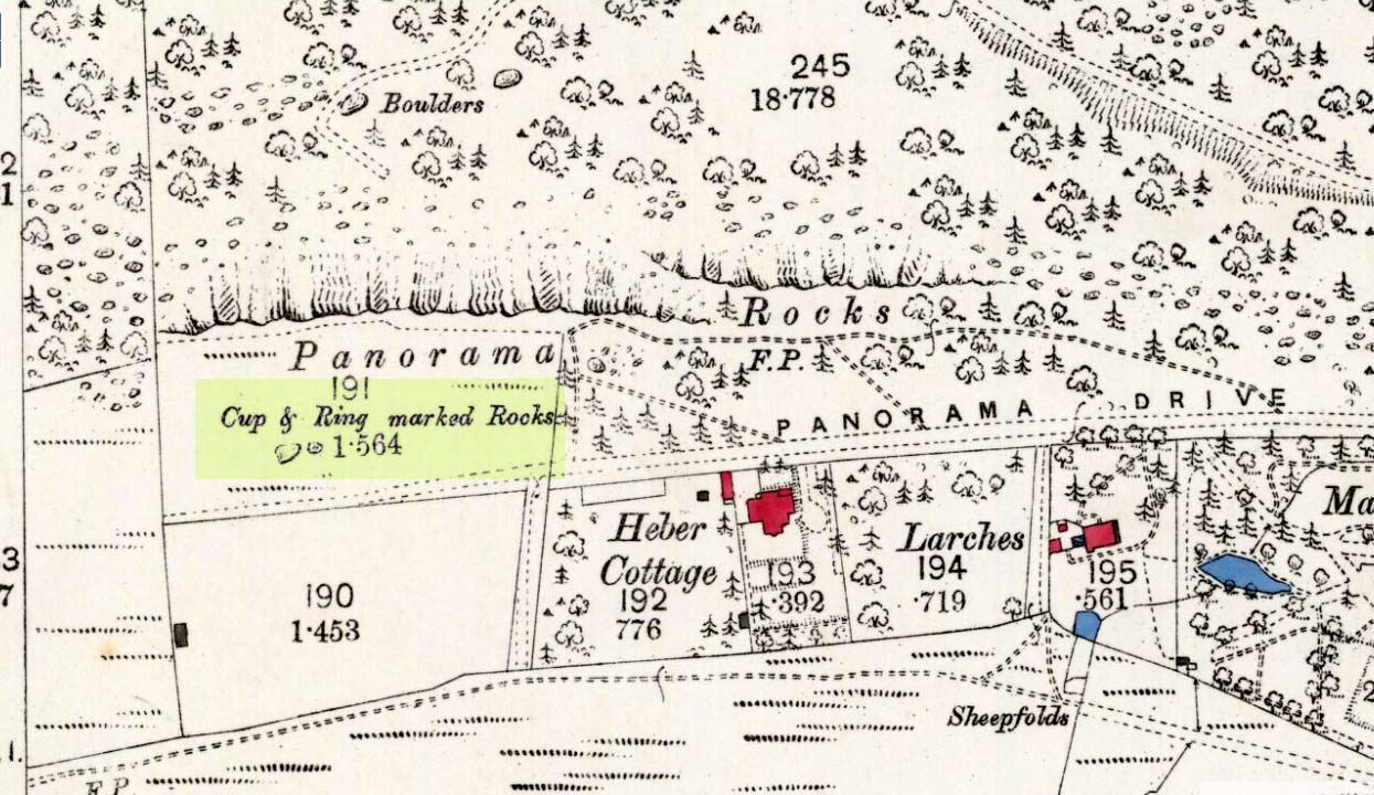
This is another of the caged Panorama Stones, found within the awful spiked fencing across from St. Margaret’s Church, just out of Ilkley centre. Originally located ¾-miles (1.2km) WSW of its present position in Panorama Woods (at SE 10272 46995), along with its petroglyphic compatriots in this cage, the carving was moved here in 1890 when a Dr. Little—medical officer at Ben Rhydding Hydro—bought the stones for £10 from the owner of the land at Panorama Rocks, as the area in which the stones lived was due to be vandalized and destroyed. Thankfully the said Dr Little was thoughtful and as a result of his payment he had some of the stones saved and moved into their present position.
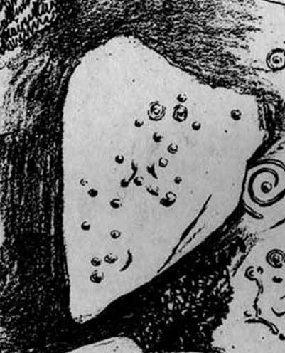
Original location of stonesJ.T Dale’s 1879 sketch
It was first described by the northern antiquarian and petroglyph pioneer, J. Romilly Allen (1879) , who saw it in the now-destroyed “rough inclosure”, as he called it, along with the other stones now in the same Ilkley ‘cage’. Its present position does it no justice whatsoever in terms of its original position. It was ostensibly a rocking stone: this seemingly trivial-looking boulder was sat on top of the much-cropped Panorama Stone 228 (a yard east of the three in this outdoor cage). Allen (1879) was fortunate enough to have seen the stone before it was uprooted, telling us how this topmost stone, “has eleven cups, wo of which are surrounded by single rings.” The modern archaeologist John Hedges (1986) told it to be in a “bad state,” with “very worn carvings, fourteen cups, one with partial ring and groove.” Its situation deteriorated further, as stated by rock art students Boughey & Vickerman (2003), who noted,
“medium-sized, roughly triangular rock, its surface recorded as in a bad state in 1986 and now (2002) even worse. Fourteen cups, one with partial ring, one groove.”
And its condition isn’t helped by its inaccessibility, when groups like the ‘Friends of Ilkley Moor’ or the local archaeologist should be at least annually cleaning this and the adjacent carvings. If they’re incapable, there are sincere people in antiquarian, history and pagan groups who would probably help out…
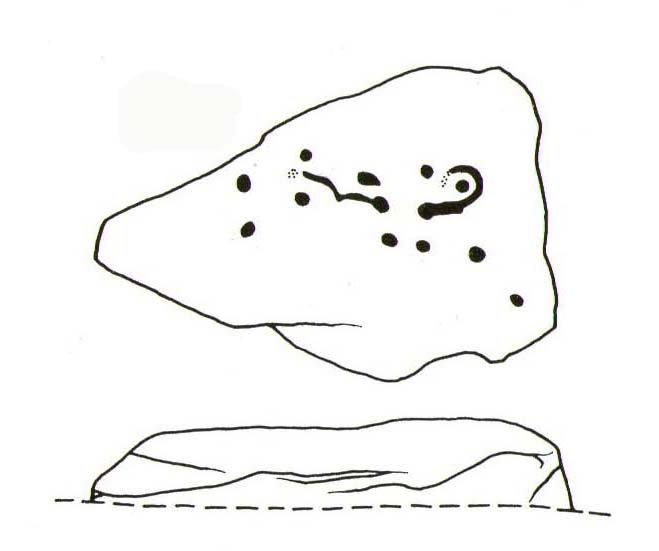
John Hedges 1986 sketchFaint cupmarks visible
In truth, this carving cannot be seen in isolation, nor merely reduced to a numeric catalogue in some rock art corpus. We must contextualize its relationship with the once much-larger multiple cup-and-ring stone on which it sat and then see it as it was in the landscape. Originally of course the rocking stone was Nature’s very own creation. As humans began migrating over and eventually occupying this once-wooded arena, the rocking stone became intimately related with animistic magickal rites and, over time, petroglyphs began to be etched upon the stone. Most probably the flat underlying rock surface was carved upon first, and a symbiotic relationship was forged between Earth’s surface and the small rocking stone, both of which were used in oracular and other rites. Over centuries, as the cups and rings on the earthfast stone grew, the mythic status of this small rocking stone allowed for the encroachment of carvings, and eventually cup-marks began to be etched upon it too. Later still, as the neolithic period moved into the Bronze Age, the people began to build a low-walled stone enclosure around this and the nearby multiple-ringed carving – similar to the multi-period enclosure at Woofa Bank and other sites on these moors. It was all a very long and gradual process.
In truth, the mythic status of this once-impressive site would have been maintained—in one form or other—well into the medieval period. But that’s another matter altogether…
Bennett, Paul, The Panorama Stones, Ilkley, TNA: Yorkshire 2012.
Bennett, Paul, Aboriginal Rock Carvings of Ilkley and District, forthcoming.
Boughey, Keith & Vickerman, E.A., Prehistoric Rock Art of the West Riding, WYAS: Leeds 2003.
Cowling, Eric T., Rombald’s Way, William Walker: Otley 1946.
Downer, A.C., “Yorkshire Archaeological and Topographical Association,” in Leeds Mercury, August 28, 1884.
Eliade, Mircea, The Sacred and the Profane: The Nature of Religion, Harcourt, Brace & World: New York 1959.
Hadingham, Evan, Ancient Carvings in Britain, Souvenir Press: London 1974.
Hedges, John, The Carved Rocks on Rombald’s Moor, WYMCC: Wakefield 1986.
Heywood, Nathan, “The Cup and Ring Stones of the Panorama Rocks”, in Transactions Lancashire & Cheshire Antiquarian Society, Manchester 1889.
Speight, Harry, Upper Wharfedale, Elliott Stock: London 1900.
Acknowledgements: With huge thanks to both Dr Stefan Maeder for help in cleaning up the stones; and to James Elkington for allowing use of his photos in this site profile.
From Ilkley centre, take the road up to Cow & Calf, going past the hotel and along Hangingstone Road for a half-mile until you meet some walling on the right of the road. Stop and walk up the small beck, veering to the left as you approach the brow of the hill. Keep walking up the beck onto the moor where you’ll eventually reach its source, as shown in the photo here!
Archaeology & History
This once fast-flowing spring of fresh sparkling water has seen better days. The site has two openings in the Earth about 10 yards east and west of each other, both discernible by the notable difference in vegetation on the moors here, where richer hues of green created by the waters cut a small channel down the moorland slopes through the usual hues of heather.
The waters taste fine when they’re in flow, but much of the land here has fallen into shallow marsh and with the inevitable falling of the water table thanks to the stupid arrogant Industrialists, very little of the goodness is available. But it wasn’t always like this. Certainly when our prehistoric ancestors carved the rock art close by the source of the waters, then later constructed the large ritual enclosure immediately west of the springs, the waters would have been very important—and in much greater profusion—for simple nourishment and for rituals enacted at the site.
Whether you’re coming here from either Baildon, or Shipley, head for the Cricketer’s Arms pub on Green Road (ask a local). About 50 yards uphill from the pub, on the other side of the road, notice the small pool on the green surrounded by large rocks: it’s the small stone about 15 yards behind the source of the spring. The goats living there usually give the game away!
Archaeology & History
This small stone, found amidst a cluster of others surrounding the medicinal Crutch Well, has its name from the friendly goats who live hereby and, when I came here for the first time in a while the other day, had trouble getting one of the little fellas to shift from his stone! We first found this when we did a lotta venturing around the area when we lived nearby as kids. This particular stone was noted during one of our many exploratory rambles round here, albeit briefly, when I wrote:
“Before going up the slope to Robin Hood’s House we looked at the stones around Crutch Well and found one with some cup-marks on it, on the grass behind the waters.”
I can’t say for sure, but think this carving was later added in the Boughey & Vickerman (2003) survey as stone no.193. They described the stone as:
“Creamish coloured rock about 1m N-S and less than 0.5m high carries two possible shallow cups to centre of surface and a possible third cup (doubtful) to N.”
Close-up of the cups
This would seem to be the stone, though there is another faded fourth cup, between the ‘doubtful’ cup and the two distinct ones, with a faded carved line running from it. Their grid-reference isn’t accurate for this and a companion single cup-marked rock (which I’d say was dodgy!), so I’m not 100% sure that we’re dealing with the same carving. There are a lot of small rocks here and in the fields opposite, many with industrial marks on them which, over the years, have faded and give the appearance of cup-markings — which most are not!
References:
Bennett, Paul, Of Cups and Rings and Things, unpublished: Shipley 1981.
Boughey, Keith & Vickerman, E.A., Prehistoric Rock Art of the West Riding, WYAS: Wakefield 2003.
From Ilkley, take the same directions to reach the Haystack Rock; then walk east along the edge of the moor, past the Pancake Stone and keep along the footpath for more than 800 yards till you see the large cairn above-right of the footpath by about 20 yards, a short distance before you’d hit the Rushy Beck. Walk to the cairn, and then past it along the path (west) heading onto the moor for another 30-40 yards, checking the rocks on the ground thereby. You’ll find it!
Archaeology & History
Scruffy sketch I did of the stone, c.1982
Described in John Hedge’s (1986) survey as a “long, low, smooth grit rock, partly covered with heather. Seven clear cups”, we first found this carving when we were out bimbling on one of our hundreds of ventures on these moors as kids—on this occasion, as I recall, seeking out a cup-and-ring stone that Stuart Feather discovered and mentioned in an early Yorkshire Archaeology Journal. Less than a yard away from the one which Mr Feather described (the overgrown cup-and-ring stone no.375) was this curvaceous female rock, with seven simple cup-markings, mostly on its northeastern side.
When the heather is low in this area, you can clearly make out extensive remains of prehistoric walling 11 yards east of the cup-marked stone, running north-south. This eventually meets up with another line of walling that runs east-west and bends back around on the western sides of the carving about 20 yards away, seemingly encircling it. This enclosure will be described in greater detail at a later date.
References:
Hedges, John (ed.), The Carved Rocks on Rombalds Moor, WYMCC: Wakefield 1986.
Boughey, Keith & Vickerman, E.A., Prehistoric Rock Art of the West Riding, WYAS: Wakefield 2003.
Fom Burley train station, take the road uphill onto the moor edge, turning right for a coupla hundred yards where the road runs up the side of the Coldstone Beck. Walk up the stream until you hit the footpath that takes you onto the moor proper, on the righthand (west) side. Once on the level, note scatter rocks on the near horizon above you and the faded track that runs up towards them. Walk up here, keeping your eyes peeled for the small chair-shaped rock immediately left of the pathway. You can’t really miss it.
Archaeology & History
One of an increasing number of carvings that I’m finding have curiously not been included in the general rock art surveys of the region (Boughey & Vickerman, 2003; Hedges 1986). We first found this—Jon Tilleard and I—when we were foraging for such carvings in the 1970s and early ’80s and the scruffy drawing here is taken from one of my early notebooks (1981) that explored the archaeological remains on these moors.
Scruffy drawing of the stone, c.1982Close-up of cup-marks
The name of the stone comes from the slightly chair-like shape of the rock on which the blatantly obvious cup-markings can be seen. There are at least six of them, with a possible seventh near the top of the rock. Some curious eroded markings can still be to the left-side of the main cups, but I’m unsure as to their nature and they may be just geophysical. Above and around this rock are a number of medieval pit workings, quarrying and scatterings of other rocks, none of which have been found to possess cup-and-rings.
References:
Bennett, Paul, Of Cups and Rings and Things, unpublished: Shipley 1981.


")
")