Ffynnon Rufeinig, Llandudno, Caernarvonshire

Healing Well:  OS Grid Reference – SH 76551 83858

Also Known as: 

  1. Ffynnon Llety Fadoc
  2. Roman Well

Archaeology & History

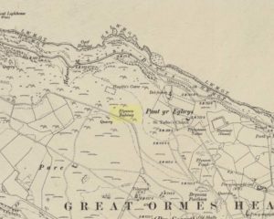
Ffynnon Rufeinig, 1901 OS-map

To be found on the legend-filled landscape known as the ‘Great Orme’, this ancient well was highlighted on the 1901 OS-map of the region, on the south side of the track.  Sadly,  despite an occasional puddle that fills the old trough when She rains, its waters are no longer running.  H.C. Jones (n.d.) informed us that this was a ‘Roman Well’, which tradition said was a place they used when they invaded this part of Wales, although Paul Davies (2003) thought this “to be wishful thinking”.

Despite this, in recent years the walling around the well has been rebuilt by the track-side and a stone plaque with the words ‘Roman Well’ has been mounted to tell you that you’re at the right place.

References:

  1. Davies, Paul, Sacred Springs, Blorenge: Llanfoist 2003.
  2. Jones, H. Clayton, “Welsh Place-Names in Llandudno and District” in Mountain Skylines and Place-Names in Llandudno and District, Modern Etchings: Llandudno n.d. (c.1950)

© Paul BennettThe Northern Antiquarian


Llanerch Farm, Llanfihangel-nant-Melan, Radnorshire

Cup-Marked Stone:  OS Grid Reference – SO 1576 5858

Also Known as:

  1. Llanerch Stone
  2. NPRN – 306082

Archaeology & History

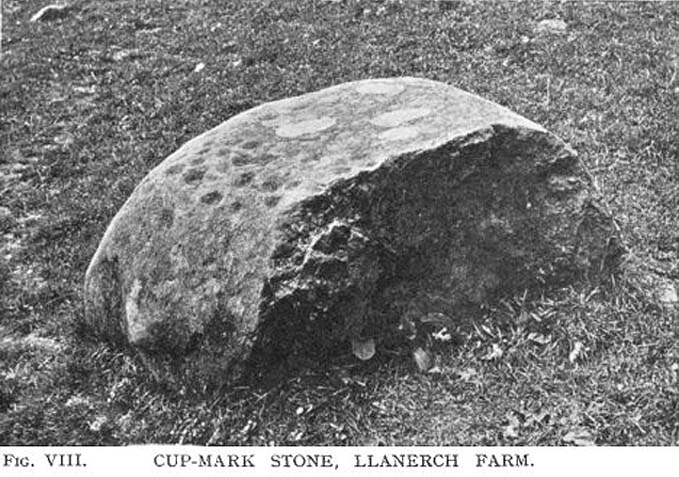
Llanerch cup-marked stone (after Watkins, 1932)

A small and simple cup-marked boulder, hidden away in the Welsh hills, all-but unknown even to cup-and-ring fanatics!  It’s nowt special to look at, reminding me somewhat of the numerous cup-marked rocks that scatter the edges of Baildon Hill in Yorkshire.  Found close to a number of other prehistoric sites, the stone isn’t in its original position so we’re unable to tell whether it was associated with any tombs (as is probable).  The carving consists of around 32 cup-marks, with some 18 of them visible on its upper face.  It’s likely that there were more cups on it originally, for when it was first found (as shown in the photo here, taken soon after being discovered) one side of the stone had been split away, but the other section was nowhere to be seen.  Alfred Watkins (1932) told how it was first discovered:

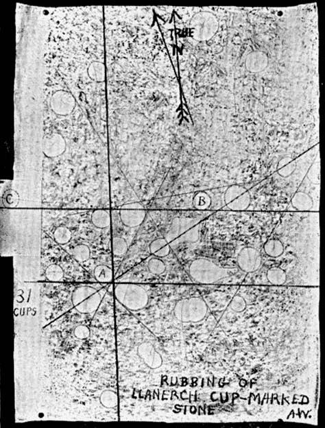
“Following a visit by the Woolhope Club in 1928 to that fine mound on Radnor Forest—Cruger Castle…a fellow member (Mr. Walter Pritchard), working on alignments, discovered a fine cup-marked stone, at Llanerch Farm, a little south of the mound.  I visited and photographed the stone the same year, and took a rubbing of the cup-marks on it, also taking as careful a bearing as possible, and marking it on the paper while on the stone.”

Its isolation is a little unusual, but there are likely to be other carvings scattering the nearby hills and valleys awaiting discovery by enthusiastic explorers.

Folklore

The great ley-hunter himself, Alfred Watkins (1932) — following in the footsteps of some of his contemporaries it’s gotta be said — used this carving to add fuel to his notion of leys and aligned sites, thinking that the cup-markings on  the stone were representative of such things, etched thousands of years back to be used by other travellers.  Can’t see it misself — but then I did spend a few years looking at the potential relevance cup-and-rings had with alignment features when I was a boy, ruining many a-map and finding they had no relationship whatsoever to such things!  But it seems that Mr Watkins was still going through the exploratory phase at the time, because, after taking a rubbing of the stone he told:

“I also (as soon as I got home) tested for alignments, and inked in those of four cups which I found, as I considered lines of three to be of no value as proof. I could not at that time see any tangible proof of anything, and put it down to this (broken) stone having probably been moved. The reproduction I give is of this crude rubbing exactly as I finished it (outlining then the rather indefinite edges of the cups) in 1928.”

References:

  1. Sharkey, John, The Meeting of the Tracks: Rock Art in Ancient Wales, Gwasg Carreg Gwalch: Llanrwst 2004.
  2. Watkins, Alfred, Archaic Tracks round Cambridge, Simpkin Marshall: London 1932.

© Paul Bennett, The Northern Antiquarian


Penbont, Hundred House, Radnorshire

Standing Stone (destroyed):  OS Grid Reference – SO 117 544

Also Known as:

  1. Hundred House Standing Stone

Archaeology & History

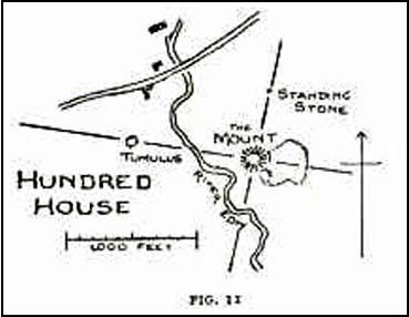
Position of the old stone (on one of Alf’s leys)

In a field less than 200 yards north of an old medieval mound known as The Mount, the great ley-hunter Alfred Watkins (1925) described a standing stone that used to be here along one of his leys, but which, even then, had been “inexplicably blown into several pieces by a quarrymen’s charge.”

The stone was said to have originally come from an adjacent field and then moved next to yet another monolith, which was also broken up. Can any remnants of these poor fellas still to be seen anywhere nearby?  Or is it a case of yet another one bites the dust?

References:

  1. Watkins, Alfred, The Old Straight Track: Its Mounds, Beacons, Moats, Sites and Mark Stones, Methuen: London 1925.

© Paul Bennett, The Northern Antiquarian


Croes-llechau, Bronllys, Breconshire

Long Barrow (destroyed):  OS Grid Reference – SO 169 357

Also Known as:

  1. Croesllechau

Archaeology & History

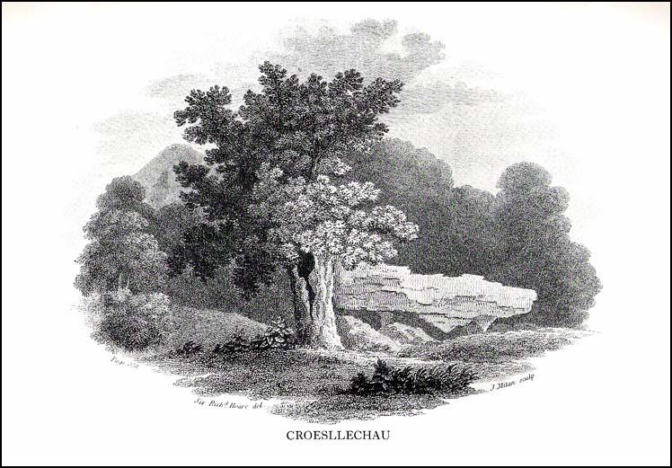
It appears to have been Theophilus Jones who first mentioned this all-but-lost megalithic tomb, more than 200 years ago.  He told that,

“In a field called Croeslechau about two miles eastward of (Talgarth), but in the parish of Bronllys and on a farm called Bryn-y-groes, is a cromlech, not merely interesting on account of its antiquity, but from the circumstance of a white thorn growing close, and indeed under part of it, which has gradually raised the horizontal or covering-stone several inches out of its original position; it is therefore not only venerable as a relic of very ancient days, but as a natural curiosity.”

Croesllechau tomb in 1809

Thankfully he gave us the fine old drawing of the tomb, here reproduced.

Although shown on an 1832 map of the region, when Crawford (1925) came to describe this old tomb it had already been destroyed.  He told that,

“the site is unknown and all memory of it is has completely vanished in the neighbourhood. Mr Evan Morgan had visited the site and reports that no traces of the ‘cromlech’ were visible; nor were enquiries of the farmer at Bradwys any more successful in identifying the site.  It is not unlikely that the monument was destroyed when a new road was made…”

References:

  1. Crawford, O.G.S., The Long Barrows of the Cotswolds, John Bellows: Gloucester 1925.
  2. Jones, Theophilus, History of the County of Brecknock, volume 2, George North: London 1809.

© Paul Bennett, The Northern Antiquarian


Spread Eagle Cursus, Aberllynfi, Breconshire

Cursus Monument:  OS Grid Reference – SO 162 376

Archaeology & History

It seems that very little remains of this site, and there is some doubt over its authenticity.  Described in Alex Gibson’s (1999b) essay on the cursus monuments of Wales, he said this ‘cursus’ consists of,

“A cropmark of two parallel ditches orientated SE-NW, 15m apart and traceable for some 130m. It runs perpendicular to the present course of the River Wye 50m to the NE.  No terminals are visible, but there is a large ring ditch across the river 450m to the NW. A closely-grouped cluster of some 8 ring ditches is visible on a gravel terrace some 150m to the E,” but adds finally that “the identification of this site is suspect and may represent a fossil field system.”

The likelihood of the site being genuine seems to come from the “cluster of eight ring ditches on the gravel terrace some 150m to the east.”  Gibson (1999) also thinks how “the parallel ditches seem to be aligned on a ninth large ring-ditch 450m to the northwest and across the river.”  Ley-hunters have been scorned by archaeo’s for making such confounded comments!   The presence of a long cairn south of the cursus was also thought to add weight to the sites veracity.

Does anyone know what the present position on this site happens to be?

References:

  1. Gibson, Alex, The Walton Basin Project, CBA: York 1999.
  2. Gibson, Alex, ‘Cursus Monuments and Possible Cursus Monuments in Wales,’ in Barclay & Harding’s Pathways and Ceremonies, Oxbow: Oxford 1999b.

© Paul Bennett, The Northern Antiquarian


Sarn-y-Bryn-Caled, Belan, Montgomeryshire

Cursus:  OS grid reference – SJ 217 048

Also Known as:

  1. Welshpool Cursus

Archaeology & History

Much has been written about this ancient site.  Indeed, the archaeologist Alex Gibson (1999) told that, “the ritual complex at Sarn-y-bryn-caled has been extensively studied…and a development sequence based on relative and absolute chronologies, as well as site analogy, has been proposed.”  Created over a lengthy period spanning nearly 2000 years, Gibson (1999b) described this monument as a

“cropmark showing as two parallel ditches, 12m apart, running SW-NE for a distance of 370m. Causeways are visible through both side ditches. The terminals are not readily visible on the aerial photographs but have been proven with geophysical survey. The terminal ditches are straight and at right angles to the side ditches. Excavations proved the ditches to be 2m across at the gravel surface and c.0.8m deep. Charcoal from the base of the ditch provided a C14 date of 4960<>70BP. Silting patterns in both ditches and the raised profile of the gravel surface suggest external banks. Towards the NE end of the cursus is a cluster of circular ritual monuments comprising a large pit, timber circle, two ring ditches and a pennanular ring ditch. A possible second pennanular enclosure was located towards the SW end by geophysical survey.”

Less than 200 yards north of the northeast terminal is a second cursus-looking monument, ascribed in Gibson’s (1999b) survey as Sarn-y-bryn-caled II and which runs dead straight for 250 yards.  Although being nearly 40 foot across, Gibson thinks this long stretch is more likely to be the remains of an old trackway or road, telling that the very title — Sarn-y-bryn-caled — or “road by the hard hill”, may derive from this secondary linear feature.

Folklore anyone…?

References:

  1. Gibson, Alex & Simpson, Derek (eds.), Prehistoric Ritual and Religion, Sutton: Stroud 1998.
  2. Gibson, Alex, The Walton Basin Project, CBA: York 1999.
  3. Gibson, Alex, ‘Cursus Monuments and Possible Cursus Monuments in Wales,’ in Barclay & Harding’s Pathways and Ceremonies, Oxbow: Oxford 1999b.

© Paul Bennett, The Northern Antiquarian


Llangynidr Bridge, Llangynidr, Breconshire

Standing Stone:  OS Grid Reference – SO 1562 2039

Also Known as:

  1. Gliffaes Stone
  2. Llywn y Fedwen

Getting Here

Not too difficult – and its size makes it pretty easy to spot!  About 100 yards across the river bridge from Llangynidr, there’s a small path heading into the trees by the riverside. Walk along it, or whichever way you find easiest to walk along the riverbank.  Then as you reach the third field along, look up into the hedgerow-cum-fence above you and you’ll notice the old stone sticking up!  Head for it!

Archaeology & History

A 14 foot tall standing stone with a most peculiar ‘modern’ history to it.  Some of you will like this, others may have palpitations – but… In recent times, since the notion of “energy at megaliths” have been in vogue, this was one of the first monoliths found to possess magnetic anomalies.  Described by the writer Francis Hitching (1976), he asked the Welsh dowser Bill Lewis to dowse at this stone and checked the results. Lewis dowsed a spiral of ‘energy’ rising up the stone as he did at many standing stones, and urged Hitching to see if he could bring his findings to the attention of any scientists.  So Hitching contacted the physicist professor John Taylor — he of Black Holes fame, of Kings College, London — who felt that Lewis’ dowsing finds were probably due to him sensing subtle changes in the magnetic field of the stone.  And so with this in mind, he sent a young Argentinian physicist called Eduardo Balanovski, armed with a gaussmeter, to see what they could find. As Hitching later wrote:

“What Balanovski found surprised him very much. After checking the background levels and setting the meter at zero, he pointed the measuring probe at the stone. The needle on the dial shot up, showing an anomaly far greater than the few thousandths or hundredths of a gauss that would have been normal…

“Balanovski has no doubt that the basic anomaly…is significant: ‘The point is that a water-diviner told us about it, and we went there and found something measurable. It may be the stone contains, geologically, the reason for the anomaly. Or it may be caused by something we don’t yet understand. But I do not personally believe that the stone was accidentally chosen or accidentally placed. The people who put it there knew about its power, even if they didn’t know about electromagnetism.'”

This initial finding brought Taylor himself to the place, where he, Balanovski and Lewis set to work.

“Lewis was filmed marking with chalk the places on the stone where he dowsed ‘energy nodes.’ When the gaussmeter probe was passed down the stone, it did register increases of magnetism at the marked points – there seemed to be ‘a very strong field on and around the stone, which seemed to fall in bands,’ as Hitching put it. It was a very impressive demonstration. Taylor urged caution, pointing out that much more work would need to be done to be sure of such reactions.”

Further work was eventually carried out by the Dragon Project, where no anomalous readings were found. Hmmm….

References:

  1. Devereux, Paul, Places of Power, Blandford: London 1990.
  2. Hitching, Francis, Earth Magic, Cassell: London 1976.

© Paul Bennett, The Northern Antiquarian