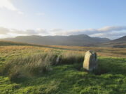
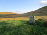
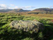
Craig Hill cluster (3), Kenmore, Perthshire

Cup-and-Ring Stone:  OS Grid Reference – NN 81307 44419

Getting Here

Craig Hill petroglyph cluster

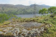
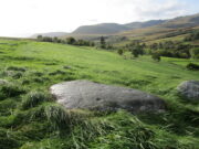
From Kenmore go east up the steep mountain road towards Glen Quaich, or if you’re coming from Amulree, go west along the same glen.  After 2½ miles (4km) up the Kenmore route (nearly 9 miles on the Amulree route) you’ll reach a small lochan on your left (you’ve got a very small parking spot a coupla hundred yards before the loch).  A gate and stile past the loch takes you east along a track into the moors.  More than a mile on, the track splits, but you need to keep to the left and follow the track along the wallside for another 400 yards or so, where you’ll see a small crag of rocks 100 yards down the slope on your right. That’s your target!

Archaeology & History

The stone in question

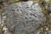
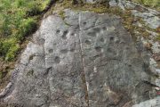
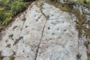
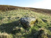
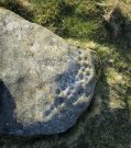
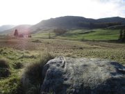
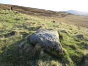
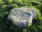
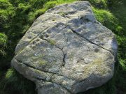
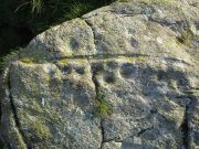
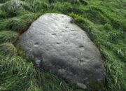
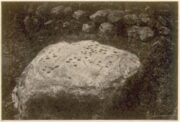
One of at least six rocks next to each other that possess cup-and-rings, this is the most notable of the bunch inasmuch as it’s the one that stands out above all the others.  At first sight it doesn’t look impressive: a shallow scatter of nine or ten cup-marks can be seen when the light’s alright, but that’s about it.  This is what George Currie (2005) noticed when he first came across it in 2004, describing it simply as “a boulder with 10 cups” a few yards away from one of it’s fellow petroglyphs (CR19, or the Craig Hill cluster-2 carving).  But there’s much more to it than that.  Unfortunately when we visited here, we weren’t blessed with good daylight, so were unable to get a decent appraisal of the entire design and have most probably missed some elements.

Curious double-ringed eye
General overview of design

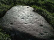
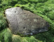
On the top sloping surface are  six or seven cup-marks; another two or three are on a secondary lower level of the stone.  Of those on the top, at least two of them have surrounding rings: one with a carved line coming out to the southeast; the other having a more extravagent appearance, surrounded by what looks like a secondary outer “oval”, or eye-shaped design.  It’s ununsual.  Other lines intersect these cup-and-rings, but it was difficult to say with any certainty whether they were Nature’s handiwork, or had been modified by humans.  Below these on a slightly lower level are two or three single cup-marks, one of which, close to the edge of the rock, appears to have an incomplete ring round it—but this might have just been a trick of the light.  Another visit is required for a better appraisal…

References:

  1. Currie, George, “Craig Hill (Dull parish): Cup-and-Ring Marked Rocks,”in Discovery & Excavation Scotland, NS Volume 6, 2005.

Acknowledgements:  Huge thanks to Prof Paul Hornby for use of his photos in this site profile; and to Myrna Hurley for getting us up there.  Cheers doods. 😉

© Paul BennettThe Northern Antiquarian

Easter Coillechat, Kilmadock, Stirlingshire

Cairn:  OS Grid Reference – NN 68830 04347

Getting Here

The cairn, looking NW

From Doune, take the A84 road to Callander.  As you pass through the hamlet of Buchany, keep your eyes peeled a few hundred yards on as the road dips down and swerves gently right, for the road sign of Drumloist (or Moist as some locals keep amending!) which goes up to the right.  It’s a small single track road that zigs and zags slowly uphill.  After exact one mile you reach a small track on your right (there one left too).  Carefully park hereby (don’t block the gate!).  Across the road, go through the gate on your right and walk along the edge of the field until you reach the burn.  Go across it, and then across the field, through the gate and you’ll see it ahead of you.  In the tick season (summer) treat the brackens as possessed by a plague and avoid it!

Archaeology & History

Looking at its stony face

A curiously forgotten place, hidden from sight, this large rounded grass-covered mound with small upright stones around one side, seems timeless amidst the open fields.  It seems alone, but the denuded chambered tomb of Ballachraggan is just visible 1.4 miles to the northwest on the near-horizon; and there’s a hidden cairnfield just a half-mile away.  This cairn measures 18 yards (N-S) by 16 yards (E-W) and stands 7-8 feet high when you look at it from its southern side.  The top of the mound is a mix of stone and grass with a slight dip in the middle, perhaps by someone in ages past digging, albeit only slightly—perhaps scared away by the old folk buried herein.

One of the most notable aspects of this site is the complete silence.  On my last two visits hereby, a fusion of mists from the low cloud above and the breathing Earth below gave an atmosphere the likes of which lived when this tomb was first built.  On one occasion hereby, no vehicles for several hours gave the silence a curious atmosphere (those of you who like sitting in the rain with the wilderness will know what I mean).  To me this is a gorgeous site…

© Paul BennettThe Northern Antiquarian

Corrymuckloch (14), Amulree, Perthshire

Cup-Marked Stone:  OS Grid Reference – NN 89253 35346

Getting Here

Looking to the SE

Take the A822 road to the northeast of Crieff and head 4-5 miles along until you enter the Sma’ Glen.  You go past Ossian’s Stone and after crossing the river the road starts to go uphill.  Nearly 2 miles up, the road levels out and at the left-side of the road is a small thin car-parking spot. Keep your eyes truly peeled for that!  Go through the gate and turn right (north), up the grassy slope.  Follow this footpath (known as General Wade’s road) straight past Corrymuckloch Farm until, about 250 yards on, the track splits.  Take the left track and nearly 500 yards along walk up the embankment on your left and look around (if you reach the gate you’ve gone too far).

Archaeology & History

Corrymuckloch (14) stone

This stone was rediscovered in July 2023 during a cursory survey of other carvings in the Corrymuckloch cluster (17 and counting!).  Most of the stone was covered in vegetation when first found, with just a single cupmark near its crown ensuring it got more attention.  Altogether there are 10 or 11 cup-marks of varying levels of erosion across the length and breadth of the rock.  The most notable one is on the northwest side of the stone, it being twice the size of the others and of much greater depth.  It may originally have been a natural depression that was enhanced when the stone was carved.  This larger cup has a smaller one attached just above it.

An intriguing find was noted all along the western edge of the rock, where upwards of a hundred small pieces of quartz—the majority of it crystal clear—were scattered between the stone edge and the soil.  This is  an ingredient that’s been noted at a number of petroglyphs in Scotland.

© Paul BennettThe Northern Antiquarian

Corrymuckloch (2), Amulree, Perthshire

Cup-Marked Stone:  OS Grid Reference – NN 89037 34706

Getting Here

Corrymuckloch (2) stone

Take the A822 road to the northeast of Crieff and head 4-5 miles along until you enter the Sma’ Glen.  You go past Ossian’s Stone and after crossing the river the road starts to go uphill.  Nearly 2 miles up, the road levels out and at the left-side of the road is a small thin car-parking spot. Keep your eyes truly peeled for that! Walk through the gate and along the track (west) for 300 yards until you reach the fence.  Once here, walk right (north) and go through the gate less than 50 yards away.  Less than 300 yards ahead of you you’ll see a small rock outcrop.  Get to it!

Archaeology & History

Rediscovered in July 2023, on this small rock outcrop it seems that only the lower east section has been carved, and it can be pretty difficult to see beneath the old layers of lichen that’s been painted across its surface.  Comprising of just four cup-marks close to each other on the top of the stone, there’s a possible fifth cup to be seen on its northeast length.  It’s nowt special to look at to be honest, but it’s worth checking out when you’re looking at the others in this cluster.  In truth, this is another that’s only gonna be of interest to the real geeks amongst you!

© Paul BennettThe Northern Antiquarian

Laighwood, Butterstone, Dunkeld, Perthshire

Cup-Marked Stone (lost):  OS Grid Reference – NO 074 458

Archaeology & History

In J. Romilly Allen’s (1882) lengthy essay on rock art in Scotland, he mentions a singular boulder that was “found by Dr Rattray” at Laighwood, near Butterstone—but, unlike him, he gave no further details regarding its appearance or exact whereabouts.  It was included in the Royal Commission (1990) survey of the area, with no additional details.  It remains lost.  In the event that you manage to rediscover it, grab some good photos of it and stick ’em on our Facebook group. (the grid-reference to this site is an approximation)

References:

  1. Allen, J. Romilly, “Notes on some Undescribed Stones with Cup Markings in Scotland,” in Proceedings of the Society of Antiquaries Scotland, volume 16, 1882.
  2. Royal Commission on the Ancient & Historical Monuments of Scotland, North-East Perth: An Archaeological Landscape, HMSO: Edinburgh 1990.

Acknowledgements:  Huge thanks for use of the Ordnance Survey map in this site profile, reproduced with the kind permission of the National Library of Scotland

© Paul BennettThe Northern Antiquarian

Drumderg (2), Tullymurdoch, Perthshire

Cup-and-Ring Stone:  OS Grid Reference – NO 18523 54950

Getting Here

Drumderg (2) cup-and-ring

Two ways: i) up the A93 road from Blairgowrie, after 5 miles turn right at the Bridge of Cally and up Glen Shee.  After another 3½ miles, keep your eyes peeled for the tiny road on the right signposted to the Drumturk Cheese farmshop.  Go up this long tiny winding road for a mile up to the cheese place and keep on this road for another 2¼ miles where you can park up near the entrance to the huge wind-farm; or – (ii) from Alyth, go up the long winding tiny Bamff Road and keep to the signposts for Bridge of Cally Glen Shee until, after about 4 miles, you reach the entrance to the windfarm.  Walk up the track to the windmills, bearing right at the first junction, then right again at the next one.  From here, shortly before the second windmill, walk down into the moor for nearly 200 yards. It’s quite a large stone.

Archaeology & History

Interlocking rings close-up

This is impressive.  Very impressive!  Found within a huge mass of other prehistoric sites in the Forest of Alyth, its only known petroglyphic bedfellows—Drumderg (1) nearly 500 yards yards south, and Drumderg (3) 120 yards north—have nothing on this one!  Where the others have basic cupmarks, this bears a series of multiple interlocking cup-and-ring designs, some with one ring, others with two, and one with four, albeit incomplete rings.

The design is etched onto the sloping face of a curved triangular ‘female’ stone.  An eroded cutting all but separates the two main components of the design, but this cut has within it a distinct singular cup-and-ring almost linking each side together.  On one side (which is near the middle of the stone) we have a complex series of multiple cup-and-rings that seem to be sequentially moving and (almost) growing into each other in some form of organic pattern.  The bottom of this growth begins from a standard cup-and-ring and runs immediately into a vulva-like slit of a cup-mark surrounded by four incomplete rings.  As the photos show, this keeps climbing upwards.

Cupmarks on its W-side
Looking into the setting sun

A more simplistic basic design has been etched onto the more western side of the stone, on the other side of the eroded cutting.  Two of the cup-marks have rings around them, with one of them seeming to give birth to another upward “growth”, but this time comprising merely of a line of more cups, curving ever-so-gently towards the middle of the stone.  Along with this there are also cup-marks on the top ridge of the stone; faint carved lines curve and intersect.  Movement seems embedded in this fixed non-linear design.  That’s my impression anyhow!

The only literary attention given to the carving seems to have been by the Scottish Royal Commission (1990) lads in one of their Perthshire inventories.  It’s simple as always, telling basically,

“this heavily weathered cup-and-ring marked boulder lies 150m south of the hut circles… The carvings are on the southwest face of the boulder and comprise: at least four cups surrounded by single rings; two cups surrounded by triple rings; an oval cup measuring 100mm by 70mm surrounded by four rings; and twenty-two plain cups marks, the largest 60mm in diameter.”

If there’s anything extra that we should puzzle over, it’s this: why do we have such an intricate carving here, living in near isolation in the midst of countless other prehistoric remains?  The answer, most likely, is that it’s not alone.  I highly suspect that others are waiting to be found up here beneath the endless ocean of heather…

References:

  1. Royal Commission on the Ancient & Historical Monuments of Scotland, North-East Perth: An Archaeological Landscape, HMSO: Edinburgh 1990.

© Paul Bennett, The Northern Antiquarian

West Lamberkine (1), Aberdalgie, Perth, Perthshire

Cup-Marked Stone (lost):  OS Grid Reference – NO 0617 2328

Archaeology & History

Site shown on 1933 map

First highlighted on the 1933 OS-map of the area, it was located alongside the old fence-line hereby, but no subsequent description of the carving has been made since then.  A small boulder and a number of other stones can be found along the line of fencing, but none seem to be possessed of petroglyphs and apart from it being shown on the old maps, I can find no reference or description of it.  It may have been destroyed.  Some researchers have wondered if the carving was mistakenly marked at this spot by surveyors who confused it with another one more than 500 yards to the southeast (and described by Fred Coles in 1903), but this would seem an unlikely error to have been made.  Whilst this was described as a simple “cup-marked stone”, its neighbour at West Lamberkine (2) was a distinct and more complex cup-and-ring design.

References:

  1. Coles, Fred,  “Notices of …(4) of Some Hitherto Undescribed Cup-and-ring-marked Stones…” in Proceedings Society Antiquaries Scotland, volume 37, 1903.

Acknowledgements:  Many thanks for use of the Ordnance Survey map in this site profile, reproduced with the kind permission of the National Library of Scotland

© Paul BennettThe Northern Antiquarian


Balnadrum, Moulin, Pitlochry, Perthshire

Souterrain (lost):  OS Grid Reference – NN 9447 5890

Archaeology & History

In Hugh Mitchell’s (1923) survey of prehistoric sites in the Pitlochry district, this long lost souterrain was thankfully captured by his pen.  Two years later John Dixon (1925) also mentioned the site, but he was ostensibly copying what Mitchell had written.  We were told:

“About 50 yards west of Balnadrum Farmhouse there is a weem or underground Pict’s house, which was revealed a good many years ago by the plough lifting one of the stone covers.  The exact position of this weem has been lost site of, but could be found without much trouble.  It was about 50 feet long, slightly curved, having an inside width of about 3½ feet and a height of about 5½ feet.  Nothing was found in it and the cover was carefully replaced.”

The site was included in Wainwright’s (1963) standard survey, where he opted for some slight scepticism regarding its nature as a souterrain due to it being about 30 miles away, or, as he said, “far withdrawn from the main concentration (of souterrains) in Angus.”  A minor point to be honest…  Nevertheless, he gave attention to the words of a Mr William McLaughlan who was the farmer at Balnadrum until the end of World War 2:

“He was born in 1873 and he estimates that the discovery was made about 1885.  He also confirms the site—it is about 150 feet west of Balnadrum, or directly across the road from the gate which leads to the farmhouse.  This spot is now covered by modern houses and/or their gardens.  To this point there is no conflict in the evidence.  Mr McLaughlan however, does not remember a 50-foot passage, and he thinks that the structure was removed.”

Nonetheless, all are agreed that an underground structure of some sort existed at this spot.  Whether or not it still hides deep beneath the soils, filled in, or whether it was destroyed when the houses were built, we know not…

References:

  1. Dixon, John H., Pitlochry Past and Present, L. Mackay: Pitlochry 1925.
  2. Mitchell, H., Pitlochry and District: Its Topography, Archaeology and History, L. Mackay: Pitlochry 1923.
  3. Wainwright, F.T., The Souterrains of Southern Pictland, RKP: London 1963.

© Paul BennettThe Northern Antiquarian

Cnoc Dubh, Moulin, Pitlochry, Perthshire

Stone Circle (destroyed):  OS Grid Reference – NN 9424 5871

Archaeology & History

Missing from the primary surveys of Burl (2000) and Barnatt (1989), a mention of this long lost site was made by local historian Hugh Mitchell (1923) in his survey of the area.  He told that,

“On the east side of the Moulin road beyond the Hydro Hotel a knoll and a clump of trees will be noticed on the right, inside the Hydropathic grounds; this knoll is known as the Cnoc Dubh, or “Black Knoll” and still bears an uncanny reputation as being an old site of Pagan worship.  There was at one time a stone circle on it, but the stones are said to have been broken up, fully 100 years ago, to build the old farmhouse of Balnadrum.”

Something ancient was there, obviously, as it was mentioned in another earlier account—albeit just a tourist guide of Atholl—which said that, on

“the knoll known as Knock-Dhu, within the (Pitlochry Hydro) grounds, are the remains of a pre-historic fort, now overgrown with pine trees.”

References:

  1. Anon., Atholl Illustrated, L. Mackay: Pitlochry c.1910.
  2. Dixon, John H., Pitlochry Past and Present, L. Mackay: Pitlochry 1925.
  3. Mitchell, H., Pitlochry and District: Its Topography, Archaeology and History, L. Mackay: Pitlochry 1923.

Links:

  1. Canmore

© Paul BennettThe Northern Antiquarian

Craig Hill cluster (6), Kenmore, Perthshire

Cup-and-Ring Stone:  OS Grid Reference – NN 81307 44422

Getting Here

Craig Hill cluster (6) stone

Follow the same directions to reach either the Craig Hill cluster (3), no.4 or no.5 carvings.  Once here, looking at the sloping moorland ahead of you, the elongated stone that’s closest to where the moorland slopes downhill is the one you’re after.  Y’ can’t really miss it!

Archaeology & History

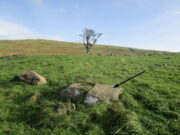
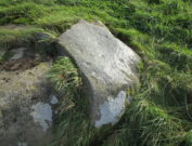
The sixth carving in this small close-knit cluster and, design-wise, the least impressive of the bunch.  There are three distinct cup-marks on the rock: two on its more southern side and one near the middle of the stone.  There may be another two cups, but these may have been part of the curious long, naturally-eroded line running along the length of the stone.  Other man-made elements may have been cut into the stone, but it needs to be seen in perfect low light to tell us one way or the other.

References:

  1. Currie, George, “Craig Hill (Dull parish): Cup-and-Ring Marked Rocks,”in Discovery & Excavation Scotland, NS Volume 6, 2005.

© Paul BennettThe Northern Antiquarian