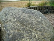
Clach na h-ealea, Clachan, Lismore, Argyll

Legendary Stone:  OS Grid Reference – NM 861 435

Also Known as:

  1. Clach na h-eala
  2. Stone of the Swan
  3. Swan Stone

Archaeology & History

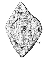
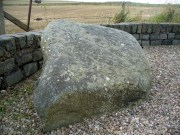
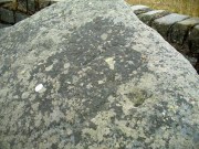
Although the lads at the Scottish Royal Commission (1974) initially described this site as a ‘Standing Stone’, it is in fact,

“an erratic boulder of granite roughly shaped in the form of a cross… It measures 0.8m in height, 0.6m in width at base, and 0.4m in width at the top…(and) the stone is supposed to have marked a boundary.”

The site was evidently of some mythic importance, as the great Cathedral of St. Moluag was built next to the stone — unless the giant cairn of Cnoc Aingil, 500 yards away, was to blame. A holy well of this saint’s name (an obvious heathen site beforehand) is also nearby.

Folklore

Although this stone was dedicated to swans, I’ve not found the story behind the name.  There were no buried swans here, but local tradition told that this old boulder could give sanctuary to anyone who touched it, or ran round it sunwise.  The Hebridean folklorist Otta Swire (1964) told that,

“anyone who claimed such sanctuary had his case considered by ‘the Elders.’ If they considered his plea justified, they ‘came out and walked sun-wise round the Swan Stone.’ If they did not approve of his right to sanctuary, they walked round it anti-clockwise and the man was then given over, not to his enemies, but ‘to Authority’ to be tried.”

This old tradition derives from well known pre-christian rites. Swire also reported that even in the 1960s here, “at funerals the coffin is always carried round the grave sun-wise before being laid in it.” An old cross placed in the Field of the Cross next to the stone was an attempt to tease folk away from heathen rites of the stone, but failed.

References:

  1. Royal Commission on the Ancient & Historical Monuments of Scotland, Argyll – volume 2: Lorn, RCAHMS: Edinburgh 1974.
  2. Swire, O.F., The Inner Hebrides and their Legends, Collins: London 1964.

© Paul BennettThe Northern Antiquarian

Witch’s Stane, Craigie, Ayrshire

Legendary Rock (destroyed):  OS Grid Reference – NS 4268 3231

Also Known as:

  1. Canmore ID 42851
  2. White Stane
  3. Witches’ Stone

Archaeology & History

It is difficult to assess the precise nature of this megalithic site, sadly destroyed some two hundred years ago.  The Royal Commission thinks it may have been a rocking stone, but the legend said of it indicates it to have been associated with a giant prehistoric cairn, although nothing remains nowadays.  The site was mentioned briefly in James Patterson’s (1863) huge work on the townships of Ayrshire, where he described the site as “standing upright” and “being in a field on Lodgehouse Farm,” near the village church.

“It stood on three stones, so high that a man could crawl under. It was blasted in 1819 to build houses.  The farmer’s wife, it is said, took some antipathy to it, and would not give her husband rest until he consented to have it removed.  A person of the name of Jamieson, and an assistant, were employed to blast it, which was accordingly done.  When broken up, it filled twenty-four carts.  Such was the feeling of sacrilege occasioned by the removal of the stone, that it was observed the farmer’s wife became blind, and continued so for eight years, when she died. Jamieson, who blasted it, never did well afterwards.  He drank and went to ruin.”

Serves them right!  Additional lore gained from a local lady in the 1870s has one of those all-too-familiar elements to it, speaking of something more substantive.

Folklore

When Archibald Adamson (1875) wrote his fine work on the history of Kilmarnock and district, folklore elements more typical of the Cailleach—whose legends abound in our more northern climes—seemed to have been attached to this missing site.  It is worth telling in full:

“After partaking of refreshments in the village inn, and indulging in a chat with the landlord, I retraced my steps to the highway, and in doing so got into conversation with an old lady who was very loquacious and well versed in the lore of the district. Amongst other things, she informed me that once on a time the church of Craigie had a narrow escape of being destroyed by a witch who had taken umbrage at it. It seems that the hag selected a large stone, and having placed it in her apron, flew with it in the direction of the building with the intention of dropping it upon its roof.  Her design, however, was frustrated by the breaking of her apron strings, for, upon nearing the object of her spleen, they gave way, and the stone fell with a crash that shook the earth. This accident seemingly so disheartened the carlin that she abandoned the destructive idea and allowed her burden to lie where it fell. The boulder lay in a field near the churchyard wall, and was known as “The White Stane.” It was long regarded with superstitious awe by many; but the farmer on whose ground it lay being of a practical turn of mind, looked upon  it with an eye to utility, and had it blasted for building purposes. Strange to relate, when broken up the debris filled twenty-five carts–a circumstance that would lead one to suppose that the witch must have been very muscular, and must have worn a very large apron.”

It is most likely that the witch in this legend originally set off from the Witch’s Knowe, more than 500 yards to the west of the church (and still untouched, despite the mess of the quarrying immediately adjacent).  Any further information on this missing site would be greatly appreciated.

References:

  1.  Adamson, Archibald S., Rambles round Kilmarnock, T. Stevenson: Kilmarnock 1875.
  2. Paterson, James, History of the Counties of Ayr and Wigton – volume 1, James Stillie: Edinburgh 1863.

© Paul BennettThe Northern Antiquarian


Girdle Stane, Dunnichen, Angus

Cup-and-Ring Stone:  OS Grid Reference – NO 52808 49737

John Sheriff's 1995 drawing of Girdle Stane

John Sheriff’s 1995 drawing of Girdle Stane

Also Known as:

  1. Canmore ID 34662
  2. Dunnichen 1
  3. Girdlestane
  4. The Girdle Stane of Dunnichen
  5. Girdle Stone

Getting Here

From The Square in Letham village, go north up Auldbar Road and out of the village for 0.6 miles (1km).  Shortly before reaching the road junction at the top, on the left-side of the road is a recess with a stone and a small aging plaque telling you that you’ve reached the Girdle Stane.

Archaeology & History

The Girdle Stane

The Girdle Stane

This cup-and-ring stone is not in its original position.  Although we know from Ordnance Survey records in the 1860s that it was located about 130 yards north of here, close to the road junction, even that is unlikely to have been its original position—but we know not where that might have been!  It is an undoubted multi-period carving, with the earliest section being our typical neolithic or Bronze Age cup-and-ring near the centre of the stone, with several outlying cup-marks toying with our intellect as per usual!  The central cup-and-ring may have an incised line running down out of it, although this isn’t highlighted on John Sheriff’s (1995) drawing of the stone.

Girdle Stane on 1865 map

Girdle Stane on 1865 map

Surrounding the central archetype, by some distance, is a much wider carved ring that almost reaches to defines the edges of the stone itself.  This large encircling motif and other features of the petroglyph—including a large elongated “S” and marks that were probably executed by the Ordnance Survey lads at the bottom corner—were ingredients which prompted Sir James Simpson (1867) to question the veracity of the Girdle Stane’s antiquity.  He wrote:

“The so-called ‘Girdle-stone’ in the…parish of Rescobie, about four feet long and three broad, is cut on its surface with two circles, the largest of which is above two feet and a half broad, and hence does not, I believe, belong to the class which we are considering in this essay”—

More recent "S"-shaped motif

More recent “S”-shaped motif

Close-up of cups, ring and lines

Close-up of cups, ring and lines

i.e., neolithic or Bronze Age petroglyphs.  And you can see his point!  My first impression when Prof Paul Hornby and I visited the site a few days ago, after the initial “that’s a cup-and-ring in the middle”, was to proclaim: “that bit’s much more recent, maybe Pictish?”  But it probably isn’t even Pictish.  This “more recent” carved element is a distinct large elongated “S”, which may have been marked onto it when the stone was used as a township boundary marker between the local parishes.  The grand historical writer Alex Warden (1882) talks about this in his magnum opus, saying:

“At the junction of two roads, a little to the northeastward of Letham, there is a rough boulder, about five feet long by three in breadth, having on its face a circle of about thirty inches in diameter, and another smaller circle about six inches across.  It is called the Girdle Stane of Dunnichen, from the larger circle resembling the utensil called the girdle, s.c. This stone marks the boundaries between the parishes of Dunnichen and Rescobie, also between the lands of Dunnichen and Ochterlony (Balmadies).  It is probably the Grey Stone referred to in a note on the marches of Dunnichen, about 1280.”

Folklore

The folklore of the stone indicates how its origins are rooted in prehistory, despite the later additional symbols.  Alex Warden (1882) tells the all-too-familiar creation myth, usually symptomatic of giant prehistoric cairns:

“Tradition says a witch was carrying this boulder from ‘the Crafts’ of Carmylie in her apron, when the strings broke, and the stone fell where it now lies.”

Carmyllie Hill is 5 miles (8km) to the south and is a place rich in fairy-lore and vandalized prehistoric sites.

References:

  1. Coutts, Herbert, Ancient Monuments of Tayside, Dundee Museum 1970.
  2. Kidd, Scott, The Churches of the Parish of Dunnichen, David Winter: Dundee 1995.
  3. Sherriff, John, “Prehistoric rock-carving in Angus,” in Tayside & Fife Archaeological Journal, volume 1, 1995.
  4. Simpson, James, Archaic Sculpturings of Cups, Circles, etc., Upon Stones and Rocks in Scotland, England and other Countries, Edmonston & Douglas: Edinburgh 1867.
  5. Warden, Alex J., Angus or Forfarshire – volume 3, Charles Alexander: Dundee 1882.

© Paul Bennett, The Northern Antiquarian


Water End Maypole, North Mymms, Hatfield, Hertfordshire

Maypole (removed):  OS Grid Reference – TL 2296 0410

Getting Here

On the east side of Warrengate Road, approached from Welham Green via Dixons Hill Road, or from Brookmans Park via Bradmore Lane.

Archaeology & History

o khy 01170

A 1920 photograph of the Public House. The Maypole was believed to have been in the garden grounds to the rear.

The exact position of the pole is not marked on the 1896 25″ OS map, as it is probable that it had been removed by the middle of the nineteenth century (like the majority of the permanent Hertfordshire maypoles), but local belief in the 1950s and 60s was that it had been in the garden of the Old Maypole (originally known as ‘The Maypole’) public house, which adjoined the smithy in Warrengate Road, Water End.  The public house is stated to have been built around 1520, with later additions, but is now a private house.

The population of Water End and nearby Welham Green was predominantly employed in agriculture, domestic service and straw plaiting, but the area’s proximity to London probably speeded the demise of the ancient traditions like maypole dancing .

Maypole North Mymms

The 1896 OS 25″ map, showing the garden ground to the rear of the public house

Doris Jones-Baker writes: “The old Hertfordshire maypoles, on May Day decorated with ribbons and a bunch of spring flowers at the top, were described as being ‘as high as the mast of a vessel of a hundred tons, painted often in a diagonal or spiral pattern from bottom to top in yellow and black, or often in vertical stripes of red, white and blue’”

Interestingly, the rear of the public house garden adjoins the Swallow Holes, a geological feature where the intermittent flowing waters of the Mimmshall Brook disappear into the chalk in as many as 15 sink holes. Hertfordshire has an ancient tradition of ‘woe-waters’ related to the local geology, where the flowing or not of a stream or spring was seen to herald ‘sorrow to come’. From personal memory the Mimmshall Brook is normally a dry stream bed which can in winter suddenly turn into a raging torrent, flooding the land behind The Old Maypole. Any tradition of it having been a woe-water has though been lost. But it is just possible that long ago the coming of May Day was also seen to herald the end of flooding of the Mimmshall Brook and may explain the siting of the pole.

The last year that people danced is not recorded, but the local maypole tradition continued; this writer remembers ribbon dancing as a very small child to a fiddle accompaniment around a maypole erected at the nearby, but long demolished Waterend C.E. Primary School, which closed in 1960.

Folklore

As well as Maypole dancing, Hertfordshire had a rich tradition of May day ritual and song, which despite the county’s proximity to London, survived long enough for some of it to be recorded for posterity. While there does not seem to be any ritual recorded for North Mymms, the following was recorded at nearby Hatfield. “On may morning, dressed in white and holding bunches of Hawthorn or, in late seasons, blackthorn blossoms the children sang door to door a local version of the May song, which began:

‘A bunch of May I bring unto you
And at your door I stand,
Come pull out your purse,
You’ll be none the worse
And give the poor Mayers some money….’”

References:

  1. North Mymms Local History Society, North Mymms Pictures From The Past, Welham Green, 2002
  2. Jones-Baker, Doris, The Folklore of Hertfordshire, B.T.Batsford, London, 1977
  3.  Kingsford, Peter, North Mymms People in Victorian Times, Brookmans Park, Hertfordshire, Privately Published, 1986

© Paul T. Hornby 2016 The Northern Antiquarian 


Lund Well, Bingley, West Yorkshire

Sacred Well (destroyed):  OS Grid Reference – SE 0973 4091

Archaeology & History

Lund Well on 1852 map

Lund Well on 1852 map

Once found in a cluster of three little wells all very close to each other near the top of the field where the Crossflatts roundabout joins up with the Aire-Valley trunk road, this is an intriguing site if you happen to be a pagan, or have an interest in druidism — and for one main reason: its name.  When I first came across a reference to the place about 25 years ago, the only piece of information I could find about it came from the arduous detailed researches of the Victorian industrial historian J. Horsfall Turner who, unfortunately, neglected to record much of the fading folklore in the region at his time.  Marked on the 1852 6-inch Ordnance Survey map, ‘Lund’ was a bit of an etymological curiosity, and Mr Turner (1897) thought the well’s name was little other than that of a local mill owner, whose nickname was ‘Lund’ Thompson.  He was guessing of course…and I thought little more about it…

Years later when looking through A.H. Smith’s (1961-63) magnum opus on the place-names of West Yorkshire, I found that he didn’t include the Lund Well in his survey.  However, an eventual perusal of Kenneth Cameron’s (1996) work told that in Old Norse place-names (and there is a preponderance of such places scattering Yorkshire and Lancashire), lund or lundr was a “‘small wood, grove,’ also had a meaning, ‘sacred grove’.” The word is echoed in old French, launde, meaning ‘forest glade’.  In A.H. Smith’s (1954) earlier etymological magnum opus he said that the word derives from a “small wood, grove, also a sacred grove, one offering sanctuary.”  However, Margaret Gelling (2000) urged caution on the origin of lund as a sacred grove and erred more to the usual English tendency of depersonalizing everything, taking any animistic attribution away from its root meaning; but we must urge caution upon her caution here!  Neither Joseph Wright (English Dialect Dictionary, vol.3 1905) nor William Grant (Scottish National Dictionary, vol.6, 1963) have entries for this word, so we must assume the Scandinavian root word origin to be correct.

One vitally important ingredient with the Lund Well is its geographical position.  For across the adjacent River Aire the land climbs uphill—and a few hundred yards above we reach the well-known and legendary Druid’s Altar, with its Druid’s Well just below.  This association is what suggests our Lund Well may have had a real association with a “sacred grove of trees”, as—despite us knowing very little about them—we do at least know that druids performed rites in sacred groves.  In Greenbank’s (1929) historical analysis of the Druid’s Altar, he was left perplexed as to the origin of its name as all early accounts and popular culture assigned it this title, and so he opted for the probability that the druids did indeed once perform rites here.  If this was true, then our seemingly innocuous Lund Well once had a much more sacred history than anyone might have thought.  Sadly, through their usual ignorance of such matters, the industrialists destroyed it….

References:

  1. Cameron, Kenneth, English Place-Names, Batsford: London 1996. 
  2. Gelling, Margaret, Place-Names in the Landscape, Phoenix: London 2000.
  3. Greenbank, Sydney, The Druid’s Altar, Bingley, R.G. Preston: Bingley 1929.
  4. Smith, A.H., English Place-Name Elements – volume 2, Cambridge University Press 1954.
  5. Smith, A.H., The Place-Names of the West Riding of Yorkshire – 8 volumes, Cambridge University Press 1961-63.
  6. Wainwright, F.T., Scandinavian England, Phillimore: Chichester 1975.

© Paul BennettThe Northern Antiquarian


Gomersal Maypole, West Yorkshire

Maypole (destroyed):  OS Grid Reference – SE 2068 2672

Archaeology & History

As in countless villages and towns across the British Isles, Gomersal also once had its maypole near or at the village centre.  We don’t know when the first maypole was erected in the village and many local sites were openly destroyed by rampant christian puritans and similar idiots.  It stood not far from the Moor Lane Well and was described by the regional historian H.A. Cadman (1930), who told:

“The Maypole was at the top of Moor Lane and one can imagine the welkin echoing to the very old song:

‘Come lasses and lads take leave of your dads
And away to the maypole hie.
For every fair has a sweetheart there
And the fiddlers standing by.
For Willy shall dance with Jane
And Johnny has got his Joan.
To trip it, trip it, trip it, trip it,
Trip it up and down.’

Yet as with maypoles up and down the land, testosterone-fuelled Springtime fall-outs happened.  Mr Cadman told:

“Very often May Day gatherings ended up with fights.  Great jealousy always existed between the inhabitants of Great Gomersal, Little Gomersal and Spen.  There is a tradition which has been handed down that the last Maypole in this district stood on Liversedge Green.  This Maypole was demolished in a fight by the Gomersalians and there is a similar tradition about the Maypole on Cleckheaton Green, so as Mr Frank Peel says, “It is evident that ancient inhabitants of Gomersal were more pugnacious than their neighbours.”  I have no evidence when the Gomersal Maypole ceased to exist, but there is abundant evidence to prove that there was one in Gomersal, the proof being that the vane is now in Batley Museum.  It is in the form of a fish.”

If anyone has any further information on this important relic, or its history, please let us know.

References:

  1. Cadman, H. Ashwell, Gomersal, Past and Present, Hunters Armley: Leeds 1930.

© Paul BennettThe Northern Antiquarian


St. Helen’s Well, Thorpe Hesley, South Yorkshire

Holy Well (lost): OS Grid Reference – SD 370 960

Archaeology & History

In Rob Wilson’s (1991) study on the saints and wells of South Yorkshire, he mentions this site which, it would seem, may have been lost to history.  In Wilson’s site-entry for the St. Helen’s Well at nearby Barnburgh, he tells that,

“There may have been other wells in South Yorkshire dedicated to St. Helen… Two 18th century surveys by William Fairbank list St. Helen’s Fieldin Thorpe Hesley and St. Ellen’s Field in Wentworth.”

Around ten different wells are highlighted in the village itself on the first Ordnance Survey map of the area, with a number of others scattered in the surrounding fields.  Any one of these may be the well in question.  Much of the region was badly disfigured by the Industrialists in their usual desecration of the landscape, which may make any recovery of this site impossible.  However, a foray into the whereabouts of William Fairbank’s survey could be worthwhile — and if St. Helen’s Field is one that remained untouched by local mining, the site could be recovered from its present “lost” status.

(Please note: the grid-reference cited above is an approximation until further data allows us to correct it.)

References:

  1. Wilson, Rob, Holy Wells and Spas of South Yorkshire, Northern Arts: Sheffield 1991.

© Paul BennettThe Northern Antiquarian


Strand Maypole, Westminster, London, Middlesex

Maypole (destroyed):  OS Grid Reference – TQ 3073 8092

Archaeology & History

This huge traditional monument was once a sight to behold!  It stood close to where an ancient stone ‘cross’ once lived.  But—alas!, with the intrusion of the incoming christians bringing a profane ‘religion’ that belongs to countries far from here, its destruction was imposed.  They destroyed so many of our ancient monuments with their hatred and ignorance… But thankfully we have some good accounts of this long-forgotten relic of London’s real history.

In A.R. Wright’s (1938) account of it, he called this “the most famous maypole in England” and it stood taller than even the great maypole that’s still raised at Barwick-in-Elmet, in Yorkshire.

There seems to have been three maypoles on this same site – the first of which was standing before the destruction of Strand’s ancient cross, where local jurisdictions and early village meetings took place.  We don’t know the date when the first maypole was erected, but it was shown on a local plan of the area “which Anthony van den Wyngaerde issued in 1543…in front of the old church of St. Mary le Strand, which was demolished in 1549.”   According to Mr Hone (1826), it could be found a door or two westward beyond “where Catherine Street descends into the Strand.”

In Edward Walford’s (1878) massive tome, he gave us perhaps the best and most extensive account of the site, telling:

“The Maypole, to which we have already referred as formerly standing on the site of the church of St. Mary-le-Strand, was called by the Puritans one of the “last remnants of vile heathenism, round which people in holiday times used to dance, quite ignorant of its original intent and meaning.” Each May morning, as our readers are doubtless aware, it was customary to deck these poles with wreaths of flowers, round which the people danced pretty nearly the whole day.  A severe blow was given to these merry-makings by the Puritans, and in 1644 a Parliamentary ordinance swept them all away, including this very famous one, which, according to old Stow, stood 100 feet high.

On the Restoration, however, a new and loftier one was set up amid much ceremony and rejoicing. From a tract printed at the time, entitled The Citie’s Loyaltie Displayed,’ we learn that this Maypole was 134 feet high, and was erected upon the cost of the parishioners there adjacent, and the gracious consent of his sacred Majesty, with the illustrious Prince the Duke of York:

“This tree was a most choice and remarkable piece; ’twas made below bridge and brought in two parts up to Scotland Yard, near the king’s palace, and from thence it was conveyed, April 14, 1661, to the Strand, to be erected. It was brought with a streamer flourishing before it, drums beating all the way, and other sorts of musick.  It was supposed to be so long that landsmen could not possibly raise it.  Prince James, Duke of York, Lord High Admiral of England, commanded twelve seamen off aboard ship to come and officiate the business; whereupon they came, and brought their cables, pullies, and other tackling, and six great anchors. After these were brought three crowns, borne by three men bareheaded, and a streamer displaying all the way before them, drums beating and other musick playing, numerous multitudes of people thronging the streets, with great shouts and acclamations, all day long. The Maypole then being joined together and looped about with bands of iron, the crown and cane, with the king’s arms richly gilded, was placed on the head of it; a large hoop, like a balcony, was about the middle of it.  Then, amid sounds of trumpets and drums, and loud cheerings, and the shouts of the people, the Maypole, ‘far more glorious, bigger, and higher than ever any one that stood before it,’ was raised upright, which highly did please the Merrie Monarch and the illustrious Prince, Duke of York; and the little children did much rejoice, and ancient people did clap their hands, saying golden days began to appear.”

A party of morris-dancers now came forward, “finely decked with purple scarfs, in their half-shirts, with a tabor and a pipe, the ancient music, and danced round about the Maypole.”

The setting up of this Maypole is said to have been the deed of a blacksmith, John Clarges, who lived hard by, and whose daughter Anne had been so fortunate in her matrimonial career as to secure for her husband no less a celebrated person than General Monk, Duke of Albemarle, in the reign of Charles II., when courtiers and princes did not always look to the highest rank for their wives.

…Newcastle Street, at the north-east corner of the church of St. Mary-le-Strand, was formerly called Maypole Alley, but early in the last century was changed to its present name, after John Holles, Duke of Newcastle, the then owner of the property, and the name has been transferred to another place not far off. At the junction of Drury Lane and Wych Street, on the north side, close to the Olympic Theatre, is a narrow court, which is now known as Maypole Alley, near which stood the forge of John Clarges, the blacksmith, alluded to above as having set up the Maypole at the time of the Restoration.

As all earthly glories are doomed in time to fade, so this gaily-bedecked Maypole, after standing for upwards of fifty years, had become so decayed in the ground, that it was deemed necessary to replace it by a new one.  Accordingly, it was removed in 1713, and a new one erected in its place a little further to the west, nearly opposite to Somerset House, where now stands a drinking fountain.  It was set up on the 4th of July in that year, with great joy and festivity, but it was destined to be short-lived. When this latter Maypole was taken down in its turn, Sir Isaac Newton, who lived near Leicester Fields, bought it from the parishioners, and sent it as a present to his friend, the Rev. Mr. Pound, at Wanstead in Essex, who obtained leave from his squire, Lord Castlemaine, to erect it in Wanstead Park, for the support of what then was the largest telescope in Europe, being 125 feet in length.  It was constructed by Huygens, and presented by him to the Royal Society, of which he was a member. It had not long stood in the park, when one morning some amusing verses were found affixed to the Maypole, alluding to its change of position and employment. They are given by Pennant as follows:

“Once I adorned the Strand,
But now have found
My way to Pound
On Baron Newton’s land;
Where my aspiring head aloft is reared,
T’ observe the motions of th’ ethereal Lord.
Here sometimes raised a machine by my side,
Through which is seen the sparkling milky tide;
Here oft I’m scented with a balmy dew,
A pleasant blessing which the Strand ne’er knew.
There stood I only to receive abuse,
But here converted to a nobler use;
So that with me all passengers will say,
‘I’m better far than when the Pole of May.'”

Along with the Strand Cross, this old maypole would have been on the ancient ley (not one of those ‘energy lines’ invented by New Age fantasists) that was first described first by Alfred Watkins (1925)—running from St. Martins-in-the-Field to St. Dunstan’s in Fleet Street. The alignment and maypole was subsequently described in greater detail in Devereux & Thomson’s (1979) work on the same subject, and again by Chris Street. (2010)

The nature of the maypole (and the nearby cross, it has to be said), may have been representative of an omphalos in early popular culture (before the christians of course)—which would put the original ritual function of the place far far earlier than is generally considered.  This is something that Laurence Gomme (1912) propounded in one of his London works and cannot be discounted.

References:

  1. Allen, Thomas, The History and Antiquities of London, Westminster, Southwark – volume 4, Cowie & Strange: London 1829.
  2. Devereux, Paul & Thomson, Ian, The Ley Hunter’s Companion, Thames & Hudson: London 1979.
  3. Eliade, Mircea, Patterns in Comparative Religion, Sheed & Ward: London 1958.
  4. Gomme, Laurence, The Making of London, Clarendon: Oxford 1912.
  5. Hone, William, The Every-Day Book – volume 1, William Tegg: London 1826.
  6. Street, Christopher E., London’s Ley Lines, Earthstars: London 2010.
  7. Walford, Edward, Old and New London – volume 3, Cassell, Petter & Galpin, London, 1878.
  8. Watkins, Alfred, The Old Straight Track, Methuen: London 1925.
  9. Wright, A.R., British Calendar Customs: England – volume 2, Folklore Society: London 1938.

© Paul BennettThe Northern Antiquarian 


Clach na Foinne, Glen Lochay, Perthshire

Legendary Stone:  OS Grid Reference – NN 50 38

Also Known as:

  1. Clach an Dlogh
  2. Wart Stone

Archaeology & History

Wart Stone, looking south

There is no written history of this site; only the quiet murmurings of a few locals whose families go back to when the english came and destroyed the people and their lives in the 18th and 19th century in the ethnic cleansing we known as The Clearances.  As with the Darach nan Sith (the Oak of the Fairies) a few miles away, the local traditions were lost, and ancient monuments destroyed.  Thankfully, due to the remote location of this site, its status remains….

It is found 2000 feet up, near an old derelict village (english academic romancers term it as ‘sheilings’).  An ancient track and stone bridge runs over the burn nearby, place-names evidence tells of a prehistoric tomb a few hundred yards west, and there’s a dispersal of forgotten human evidences scattering the south-side of the mountain all along here.  The clach (stone) sits on the very top of a large earthfast rock; is an elongated loaf-sized smooth red-coloured stone, about 14 inches long and 8 inches wide, and of a different type and much heavier than the local rock hereby.  It is said to have been a healing stone, used in earlier times to cure warts and other ailments.

Folklore

The Wart Stone itself

My first venture here was, like many in this area, amidst a dreaming.  Those who amble the hills properly, know what I mean.  I cut across the mountain slopes diagonally, zigzagging as usual, always off-path, resting by mossy stones and drinking the waters here and there.  My nose took me to the mass of giant rocks hedging into the higher regions of Allt Ghaordaidh: a pass betwixt the rounded giants of Meall Ghoaordie and Meall Cnap Laraich, where only eagles and Taoist romancers might roam.

The great rock comes upon you pretty easily.  Approaching it for the first time I wondered whether there might be petroglyphs on or around it, but the rich depth of lichens and its curious crowning elongated stone stopped any further thought on the matter.  The setting, the eagles, the colour of day and the fast waters close by, stole all such thoughts away.  In truth I must have walked back and forth and near-slept below the place for an hour or two before I gave way to rational focus!  And then my  curiosity got even more curious.

“This must be the place,” I mused, several times.

As you can see in the photo, a large natural earthfast boulder, six feet high or more, like a giant Badger Stone covered in centuries of primal lichens, has a large deep red-coloured stone on its very crown.  The stone is unlike any of the local rock and is very heavy.  I found this out when trying to prize it from its rocky mount, dislodging it slightly from the seeming aeons of vegetation that held it there.  But the moment I moved it, just an inch or so above its parent boulder, a quiet voice inside me rose sharply into focus.

“You shouldn’t have done that!”

The Wart Stone. looking east

Quickly I set it back into place, shaking my head at what I’d done.  One of those curious feelings you get at these places sometimes wouldn’t leave me, however much I tried to shake it off.  …Silly though it may sound, the echoes inside kept saying over and over to me, “you’re gonna get warts now you’ve done that!” Logically, of course, that made no sense whatsoever.  I’d only ever had one wart in my life, a couple of decades ago.  And yet, a few days later, one of the little blighters emerged on my finger!  So there was only one thing for it!  If this was a Wart Stone, I should revisit it again and place my afflicted finger back onto the wart and ask it to be taken back into the stone.

A week or so later, I clambered all the way up the mountainside again and asked the place to forgive my stupidity and take back the wart.  Apologising to the spirit of the stone, I rubbed my finger on the curious coloured rock and, I have to be honest, didn’t know what to expect.

I spent the next few hours meandering here and there over the hills and cast the thought of the Wart Stone back into my unconscious.  But a few days later it had started shrinking – and within a week, had completely gone!  This faint relic of an older culture, this Clach na Foinne had performed its old ways again, as in animistic ages past…

© Paul BennettThe Northern Antiquarian 


Crown Tree, Keillor, Perthshire

Legendary Tree (destroyed):  OS Grid Reference – NO 27279 40789

Getting Here

The Crown Tree, shown on the 1865 6″ OS map

The site of the tree may be seen from the north side of the Kettins to Newtyle road, just before the Perthshire-Angus boundary sign. It stood on the south-west side of the dip at the far end of the field, next to the raised causeway.

Archaeology & History

Nothing now remains of the tree.  The Ordnance Survey name book gives the following description, attested by Hugh Watson of Keillor, Thomas Mole of Denside and Charles Wood of High Keillor:

“[Situation] About 32 chains NE of Keillour. A large tree situated on the farm of Keillor. It is traditionally stated that Barons held their court under this tree, also that criminals were executed on it. Whence the name.”

Crown Tree stood left of the dip in front of the causeway

The tree was about 160 feet to the south-west of the boundary between the parishes of Kettins and Newtyle, on the Kettins side, both of which parishes were historically in the county of Angus, so it was likely also to have been an ancient boundary marker. Keillour, with the Parish of Kettins is now in Perthshire.

Based on the evidence of the 25″ OS maps, it seems the tree was felled sometime between 1900 and 1921.

Reference:

  1. Ordnance Survey Name Book, Forfar (Angus) Volume 52, 1857-61

© Paul T. Hornby, The Northern Antiquarian 2017