Cross Oak, Berkhamsted, Hertfordshire

Sacred Tree:  OS Grid Reference – SP 964 079

Archaeology & History

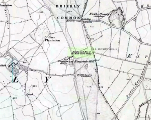
Location of the Cross Oak, shown on 1883 OS-map

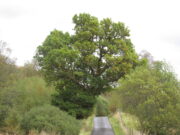
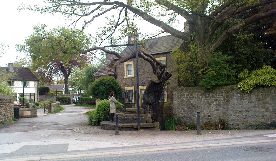
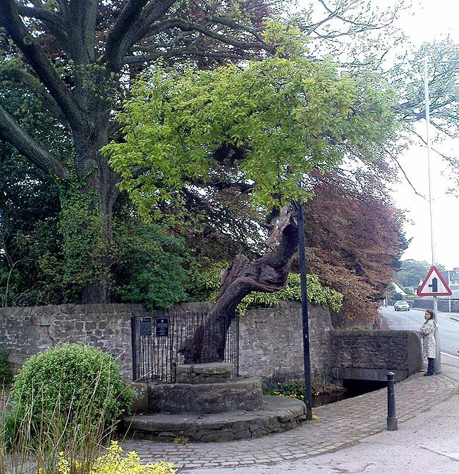
About mile south of Northchurch, on the far side of the A41 dual carriageway, somewhere past the old crossroads (or perhaps even at the crossing) an ancient tree lived—and truly lived in the minds of local people, for perhaps a thousand years or so.  Mentioned in the Lay Subsidy Rolls in 1307, the Cross Oak gave its name to the old building that once stood in the trees and the hill itself, at the place now known as Oak Corner.  Whether or not a “cross” of any form was set up by this old oak, records are silent on the matter.  Its heathen ways however, were pretty renowned! (a plaque should be mounted here)

Folklore

The first reference I’ve found of this place is in William Black’s (1883) folklore survey where he told that “certain oak trees at Berkhampstead, in Hertfordshire, were long famous for the cure of ague”—ague being an intense fever or even malaria. But a few years later when the local historian Henry Nash (1890) wrote about this place, he told that there was only one tree that was renowned for such curative traditions, that being the Cross Oak.  He gave us the longest account of the place, coming from the old tongues who knew of it when they were young—and it had it’s very own ritual which, if abided by, would cure a person of their malady.  “The legend ran thus”, wrote Mr Nash:

“Any one suffering from this disease was to proceed, with the assistance of a friend, to the old oak tree, known as Cross Oak, then to bore a small hole in the said tree, gather up a lock of the patient’s hair and make it fast in the hole with a peg, the patient then to tear himself from the tree, leaving the lock behind, and the disease was to disappear.

“This process was found to be rather a trying one for a weak patient, and by some authority unknown the practice was considerably modified. It was found to be equally efficacious to remove a lock of hair by gentle means, and convey it to the tree and peg it in securely, and with the necessary amount of faith the result was generally satisfactory. This is no mere fiction, as the old tree with its innumerable peg-holes was able to testify. This celebrated tree, like many other celebrities, has vanished, and another occupies its place, but whether it possesses the same healing virtues as its predecessor is doubtful.  It is however a curious coincidence, that the bane and the antidote have passed away together.”

The lore of this magickal tree even found its way into one of J.G. Frazer’s (1933) volumes of The Golden Bough, where he told how the “transference of the malady to the tree was simple but painful.”

Traditions such as this are found in many aboriginal cultures from different parts of the world, where the spirit of the tree (or stone, or well…) will take on the illness of the person for an offering from the afflicted person: basic sympathetic magick, as it’s known.  Our Earth is alive!

References:

  1. Black, William G., Folk Medicine, Folk-lore Society: London 1883.
  2. Frazer, James G., The Scapegoat, MacMillan: London 1933.
  3. Jones-Baker, Doris, The Folklore of Hertfordshire, B.T. Batsford: London 1977.
  4. Nash, Henry, Reminiscences of Berkhamsted, W. Cooper & Nephews: Berkhamsted 1890.

Acknowledgements:  Huge thanks for use of the Ordnance Survey map in this site profile, reproduced with the kind permission of the National Library of Scotland

© Paul BennettThe Northern Antiquarian

Fairy Oak, Killin, Perthshire

Legendary Tree:  OS Grid Reference – NN 57 33

  1. Coin Tree

Folklore

The Fairy Oak of Killin

Nothing has previously been written of this site.  Its existence came to light during one of umpteen enquiries I’d made with a well-known and very respected local lady, born and bred in Killin (sadly, a dying breed), who is known as a fount of knowledge regarding the history of the area.  We were talking about the ancient sites and folklore of the neighbourhood and, amidst being her usual helpful self she asked, “have you been to the Coin Tree?  The place where we leave offerings to the spirit of the place?”

I hadn’t.

“No, I’ve never heard of the place.”

“We keep it quiet, ” she said, “for obvious reasons.”

I knew what she meant.  The Fairy Tree at Aberfoyle is a case in point: littered with plastic pentagrams, children’s toys and so-called “offerings” of all kinds that have made it little more than a dumping ground for pseudo-pagans and new-age nuts that needs to be cleaned regularly by local folk.

Anyhow, our informant proceeded to give us directions to find the place, going out of the village, but asked that if we were to write about it, to keep its location quiet, “as the place is still used by us”—i.e., old locals.  After a slow trek along one of the roads out of the village we saw nothing that stood out.  Eventually we came across a fella relaxing in his garden and asked him if he knew anything about an old tree where offerings were made.  He gave us that look that olde locals do, to work out whether you’re a tourist or not and, after telling him what we’d been told and who had told us —that seemed to do the trick!

“You’d mean the Fairy Oak I s’ppose?  Aye,” he said, “gerrin the car and I’ll drive y’ down to it.”

So we did.  A short distance back along the road that we’d come down he stopped and walked along a to large oak tree beside the road.  We’d walked straight past it—but in truth it’s not a conspicuous tree and unless you were shown where it was, you’d miss it as easily as we did (and I’m usually damn good at finding such things!).  We thanked the fella for taking us to see it and he drove back home to leave us with out thoughts.

More coins as offerings
Coins for the little people

Embedded into the tree—some of them barely visible where the bark had grown over them—were clusters of old coins all around its trunk; some of them very old.  These had been inserted into the tree as offerings in the hope that the little people, or the genius loci would bring aid to that which was asked of it.

In a field across the road there’s a large “fairy-mound” hillock: one of Nature’s creations, but just the sort of place where many little people are said to live in many an old folk-tale.  Some such mounds are old tumuli, but this aint one of them.  It’s possible that it had some relationship with the tree where the fairy folk are said to reside but, if it did, our informants didn’t seem to know.

The important thing to recognise here is that in some of the small villages and hamlet in our mountains, practices and beliefs of a world long lost in suburbia are still alive here and there… But even these are dying out fast, as most incomers have no real attachment to the landscape that surrounds them.  Simply put: they see themselves as apart from the landscape as opposed to being a part of it.

© Paul BennettThe Northern Antiquarian 

Robin Hood’s Oak, Great Horkesley, Essex

Legendary Tree (lost):  OS Grid Reference –TL 96 28

Archaeology & History

In more than twenty volumes about Robin Hood in the Northern Antiquarian library, no mention can be found of this all-but-forgotten site, first recorded (I think) in September 1637, in the boundary perambulation account of northern Colchester.  In days of olde, folk walked the boundaries annually and so the description given here follows their very footsteps – although the landscape has obviously been altered in places since then.  Because of the length of the entire perambulation their account is rather long, so I’ve cut to the piece relating to our legendary oak tree, which gives a good idea of its location.  We meet up with them at a place called Motts-Bridge, just above a place that is today called Seven Arches Farm (TL 9630 2595):

“…and so over Mott’s-bridge, and so cross the river by Nicholas Ayleward’s howse into the meadowe crossinge over to the lower ende of West-fielde, and from thence to Buttolph’s brooke leavinge the Brooke alwais upon the left-hand, and so along to Thomas Abrige (which is righte against Robin Hood’s oake). And from thence to Black-brooke under Chesterwelle and so along the Rampiers by Horkesley Heathe to the brooke that is under Langham-park-corner…”

P.H. Reaney (1935) proposes that the ‘Rampiers’ in this account is the Iron Age hillfort of Pitchbury Ramparts.

The description of its whereabouts isn’t too clear, but in a subsequent and much longer perambulation account from August 1671, some extra topographical features are mentioned.  Starting not far from Mott’s Bridge, down Shett’s Hill to Newbridge,

“and then into the Fields in the occupation of Matth. Ayleward…through a gate a little above the Bridg: and soe along to Matth. Ayleward’s Yard, crosse the River into Matth. Ayleward’s Meadowe, and crosse that Meadowe into the lower part of Westfields, neare to which is a Foote-bridge cross the river, which is called Mott’s-bridge.  And soe along through West-fields to a Gate in a lane at or neere the north ende of a Meadow of one Mrs —, now in Samuel Duglet’s occupation, which lane parts West-fields from Bergholt, as the Parsons of each Parish, whoe were both present, affirmed; and, upon a Tree standing neere to which Gate is set a crosse.  And from thence to Butolph’s brooke, leaveing the brooke allwaies  upon the left-hand; and soe along through Mr Leming’s Meadows and Woods at the ende of them to a Bridge called Thomas Abridge, leading on to Horkesley Heath, which bridge is right against Robin Hood’s Oake, that stood on the pitch of the hill. And from thence along the Naylande Roade over Horkesley-heathe to Blackbrooke under Chesterwell, which Brooke runnes crosse the way at the foote of Horkesly cawsy…”

This second account seems to speak of the tree in the past tense, telling us that “Robin Hood’s Oake, that stood on the pitch of the hill”, but we can’t be completely sure.  I presume that there’s no longer any trace of this legendary oak tree; however, considering the fact that oaks can live to an incredible age, it may be worthwhile for a local antiquarian to follow this ancient boundary and see if, perchance, any remaining tree stump might still be there.  Y’ just never know…..

There are several other place-names in Essex relating to our mythical outlaw, including Robinhood End at Finchingfield described in 1699, and a farm of the same name nearby; plus a Robin Hood’s Inn near Loughton. (Reaney 1935)  There are probably a few more hiding away in field-name records…

NB:  The grid-reference map linked to this site is an approximation.  If someone can find the exact spot where the tree stood, we’ll update its position.   

References:

  1. Morant, Philip, The History and Antiquities of the Most Ancient Town and Borough of Colchester, W. Bowyer: London 1748.
  2. Reaney, P.H., The Place-Names of Essex, Cambridge University Press 1935.

© Paul BennettThe Northern Antiquarian

Broad Oak, Hatfield Broad Oak, Essex

Legendary Tree:  OS Grid Reference – TL 5352 2083

Also Known as:

  1. Doodle Oak

Archaeology & History

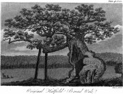
Hatfield’s Doodle Oak, 1807

Erroneously ascribed by the reverend Winsland (1952) as being the ‘Doodle Oak’, the ancient and giant tree called the Broad Oak was, as records show, always known by this name, but was subsequently replaced by another after its demise.  It was this second tree that became known as the Doodle Oak.  Winsland described it as “an immense and famous oak tree”, under whose “spreading branches in olden days the Lord of the Manor probably held his court and dispensed justice.”

The tree was described as early as 1136 AD and was probably an early tribal meeting site, or moot spot.  In Philip Morant’s (1763) work, he described it as,

“A tree of extraordinary bigness. There has been another since…called Doodle Oak.”

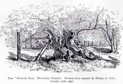
The old Oak in 1890

The Doodle Oak was thought to date from around 10-11th century and its predecessor may have been upwards of a thousand years old before this one took its place.  In 1949, one patient botanist, Maynard Greville, investigated the Doodle Oak tree-rings and found it to be 850 years old.  Other estimates suggest it was a hundred years older than that!  Whichever was the correct one, a measurement of its trunk found it to be some 19 yards in circumference – one of the largest trees ever recorded in Britain!

Sketches of its dying body were thankfully made near the beginning and the end of the 19th century: one in Mr Vancouver’s (1807) Agriculture of Essex, and the other by Henry Cole of the Essex Naturalist journal.

Doodle Oak on 1896 map

Some speculate that the Broad Oak of ancient times and the subsequent Doodle Oak were at very different places in the parish, but without hard evidence this idea is  purely hypothetical.  And whilst the name ‘broad’ oak is easily explained, the name ‘doodle’ is slightly more troublesome.  However, a seemingly likely etymology is found in the Essex dialect word dool, which Edward Gepp (1920) told,

“seems to mean, (1) a landmark; (2) a path between plots in a common field.”

The former of the two would seem to be the most likely.  This is echoed to a greater degree in Wright’s (1900) magnum opus, where he found the dialect word dool all over the southeast, meaning,

“a boundary mark in an unenclosed field.”

Giant trees on ancient boundaries, like the Broad Oak of earlier times, would seem to be the most probable reason for its name.  Today, all that’s left of the site is a small plaque on a small tree-stump, telling us what once stood here…

References:

  1. Gepp, Edward, Contributions to an Essex Dialect Dictionary, George Routledge: London 1920.
  2. Morant, Philip, The History and Antiquities of the County of Essex – volume 2, 1763.
  3. Reaney, P.H., The Place-Names of Essex, Cambridge University Press 1935.
  4. Vancouver, Charles, General View of the Agriculture of the County of Essex – volume 2, Richard Phillips: Blackfriars 1807.
  5. Winsland, Charles, The Church of Saint Mary the Virgin, Hatfield Broad Oak, Anchor: Bishop Stortford 1952.
  6. Wright, Thomas, English Dialect Dictionary – volume 2, Henry Frowde: London 1900.

© Paul BennettThe Northern Antiquarian


Goose Oaks, St. Fillans, Comrie, Perthshire

Legendary Trees (lost):  OS Grid Reference – NN 693 242

Folklore

A fascinating story of this forgotten site is detailed in Alex Porteous’ (1912) history book on this tiny parish at the eastern end of Loch Earn.  It’s a peculiar tale—and unless the story was little more than the local people ripping the piss out of the patronising incomers, its nature remains a mystery.  Porteous wrote:

“What were known as the Goose Oaks grew by the loch-side about two or three hundred yards west from the hotel.  The story is told of a celebrated goose which attained to the great age of 160 years and finally gave up this life in 1818.  It is solemnly averred by Mr (John) Brown that the history of this goose was well authenticated and that the families and individuals who successively were owners of the goose were highly respectable, and that its history was preserved entire for the period back to 1658, while he naively adds—”How long it was in being prior to that date is uncertain.”  The goose was buried at the spot indicated, and the oaks trees, two in number, of which only one remains now, planted over its grave; but the story, as regards the age, must be looked upon as apocryphal.”

One wonders what on Earth Sir James Frazer might have made of this tale!

References:

  1. Porteous, Alexander, Annals of St. Fillans, Crieff 1912.
  2. Porteous, Alexander, Forest Folklore, Mythology and Romance, George Allen: London 1928.

© Paul BennettThe Northern Antiquarian


Wallace’s Oak, Larbert, Falkirk, Stirlingshire

Legendary Tree:  OS Grid Reference – NS 847 836?

Also Known as:

  1. Wallace’s Tree

Archaeology & History

The archaeology and traditions ascribed to this ancient tree (exact position unknown) is based on words that were first penned two hundred years ago.  It was thankfully recorded with a reasonable description when William Nimmo wrote about the great Sir William Wallace in the second edition of his Stirlingshire (1817) work.  Known about in oral tradition by local people, Nimmo told how:

“Torwood was a place where he and his party, when engaged in any expedition in this part of the country, often held their rendezvous, and to which they retreated in the hour of danger.  Here is still to be seen an aged oak, well known by the name of Wallace’s Tree; which seems to have been, even then, rotten and hollow within, and is said to have often afforded a lodging to him and a few of his trusty friends. It is supposed to have been one of the largest trees that ever grew in Scotland.  It is now almost quite decayed; but, from its ruins, appears to have been of an uncommon size. The remaining stump is no less than eleven or twelve feet in diameter. It stands upon the summit of a small eminence, which is surrounded on all sides by a swamp.  A rugged causeway runs from the south through the swamp, and leads up to the tree.  Some other vestiges of the stonework are discernible, surrounding the tree in a circular form, and leading to the conjecture that this oak is of a very high antiquity; and that, having been much frequented by Druidical priests, amongst whom the oak was sacred, the causeway had been laid for their approach to it, and the performance, underneath its branches, of religious rites.”

Nimmo may have a point here.  Not necessarily of druids (although druidic traditions and reality is known from many old tracts to have continued in many of the hidden places in Scotland), but certainly in relation to the paved track leading to a what may have been a recognised moot-hill, on top of which this great oak once stood.  Great trees and ancient meeting places were held in high esteem, not only in the legends of druidism and more established animistic pantheons, but in the recognised pragmatism of local tribal gatherings, in Scotland, Wales, England and in traditional cultures all over the world. (Gomme 1880) The traces of stonework leading to the hill strongly implies an archaeological site in the paving alone; but moreso, as an important site in the traditions of the Scottish people.  The fact that these stone ruins were still visible when Nimmo visited the site in the latter-half of the 18th century in the context he describes, implies it may have been the remains of a possible crannog; or a moot hill; or even, with its great oak surmounting, a sacred grove!  In my mind, it was probably being used as a gathering place long before William Wallace and his men gathered here…

In 1880, a 3rd edition of Nimmo’s Stirlingshire was published and edited by R. Gillespie.  Herein were additional notes about Wallace’s Oak that had been uncovered by Mr Gillespie.  Although he’d visited the place,

“Not the smallest vestige…of the Wallace oak remains. Even the ” oldest inhabitant” can say nothing of it save what he has gathered from tradition.  Sir Walter Scott, in his Tales of a Grandfather, speaks of having seen some of its roots eighty years ago; and recently we were shown a treasured morsel of the tree in the Chambers’ Institute at Peebles. Wallace, undoubtedly, often chose the solitude of the Torwood as a place of rest for his army, raised and roused to oppose the tyranny of Edward.  Here he concealed his numbers and his designs, sallying out suddenly on the enemy’s garrisons, and retreating as suddenly when afraid of being overpowered. While his army lay in these woods, “the oak” was his head-quarters. Within it, the illustrious hero generally slept, the hollow trunk being huge enough to afford shelter both to himself and one or more of his associates.”

When John Gibson (1908) came to write about it, he told that “Wallace’s Oak, which stood on another part of Woodside (low Torwood), has…vanished.” No roots, no lingering trunk—nothing.  But although the tree has long since gone, William M. Stirling pointed out in 1817 that,

“A young tree is pointed out in the neighbourhood, as having sprung from an acorn of Wallace’s Oak.”

If and when we can locate the old toll-house of Broomage at Larbert, we get much closer to identifying the exact location of this long lost oak.  Then, perhaps, a commemorative plaque should surely be placed there to remind people of their great history, and included on tours of sites relating to Sir William Wallace.

References:

  1. Gibson, John C., Lands and Lairds of Larbert and Dunipace Parishes, Hugh Hopkins: Glasgow 1908.
  2. Gomme, George L., Primitive Folk-Moots, Sampson Low: London 1880.
  3. Nimmo, William, The History of Stirlingshire (2nd edition), John Frazer: Stirling 1817.

© Paul Bennett, The Northern Antiquarian 


Rivock Well, Silsden, West Yorkshire

Healing Well:  OS Grid Reference – SE 07782 44863

Getting Here

Rivock Well pool

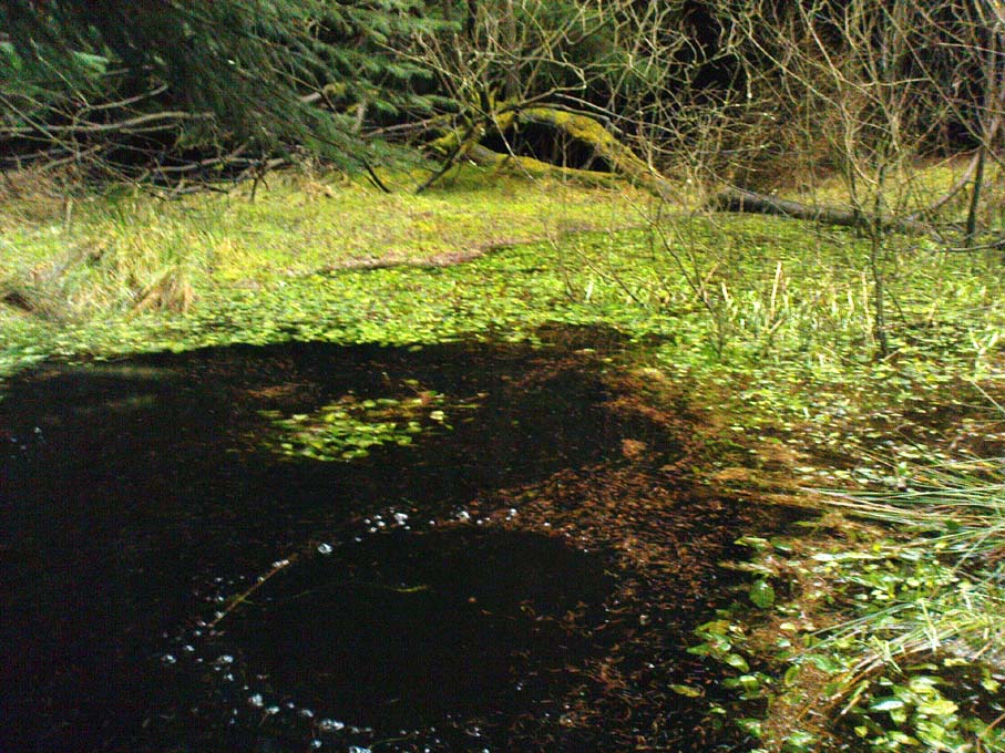
From the B6265 valley road between Bingley and Keighley, just near Riddlesden Hall, take the road up and over the canal into Riddlesden, bearing left up past West Riddlesden Hall and up Banks Lane. As you reach the T-junction at the top, where you hit the Silsden Road that goes round the moors, park up.Cross the road and follow the footpath diagonally across the bottom of the field, then when you hit the track, follow it up through the closed gates into the woods.  A half-mile along the track, watch out for the dark pool a few yards beneath you on your left.  That’s it!

Archaeology & History

The spirit and feel of this pool is a curious one: still, calming, but with a slight sense of unease at times.  It felt like this before the large forestry plantation was planted around it — so it’s good to know it’s kept its spirit intact.  I’m not quite sure how long it will last though… The small spring of water from just above the edge of the pool which in part feeds it, tastes good and refreshing after a good downpour, but sometimes in recent years the waters have slowed somewhat compared to earlier decades — an unhealthy state of affairs that’s happening all over the world.

A favourite haunt for very colourful dragonflies, deer, pheasant and other animals, very little has been written about this site.  Said by place-name authorities to get its name from an old oak that once stood by its side, the name must be pretty old as no remains of such a tree has been mentioned by any antiquarians in the last 200 years.  But the first element in the place-name “riv-ock” is an intriguing puzzle.  Does it mean simply a split oak?  Or was it a more regal in nature, and derive from the old Gaelic Righ, (proncounced ‘ree’) meaning a King’s Oak?  More probably the name relates to the “well by the twisted oak,” from the dialect word, rive, or ‘twisted’.  However, when we begin exploring dialect variations on this word, a whole host of possible meanings emerge!

Ancient people who lived on these moors obviously used this well — and no doubt had old tales of its medicinal virtues, but sadly these are lost.  All we have to remind us that our ancestors came here are the numerous cup-and-ring stones found at Rivock Edge itself, a short distance southeast of here…

References:

  1. Whelan, Edna & Taylor, Ian, Yorkshire Holy Wells and Sacred Springs, Northern Lights: Dunnington 1989.

© Paul Bennett, The Northern Antiquarian


Woodhenge, Dorchester, Oxfordshire

Timber Circle (destroyed):  OS Grid Reference – SU 5775 9513

Also Known as:

  1. Dorchester 3
  2. NMR NUMBER: SU 59 NE 53
  3. Site no. 371.21.1

Archaeology & History

Dorchester's Woodhenge in the cursus
Dorchester’s Woodhenge in the cursus

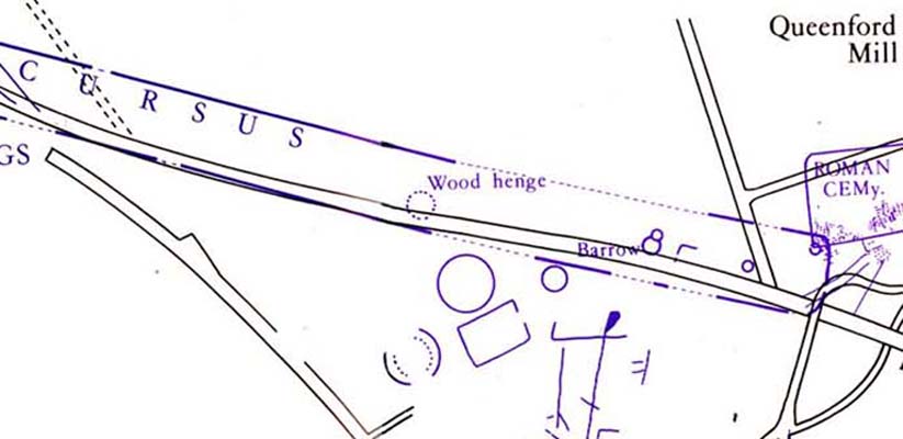
Although ascribed as a wooden ‘henge’ by archaeologist Jean Cook, the site is more accurately a simple timber circle.  Cook (1985) described this little-known “Wood Henge” monument, as she called it, sat inside the lower southeastern end of the impressive Dorchester Cursus monument.  The site was obviously of some ritual importance, for a variety of reasons.  It was excavated in 1981 and,

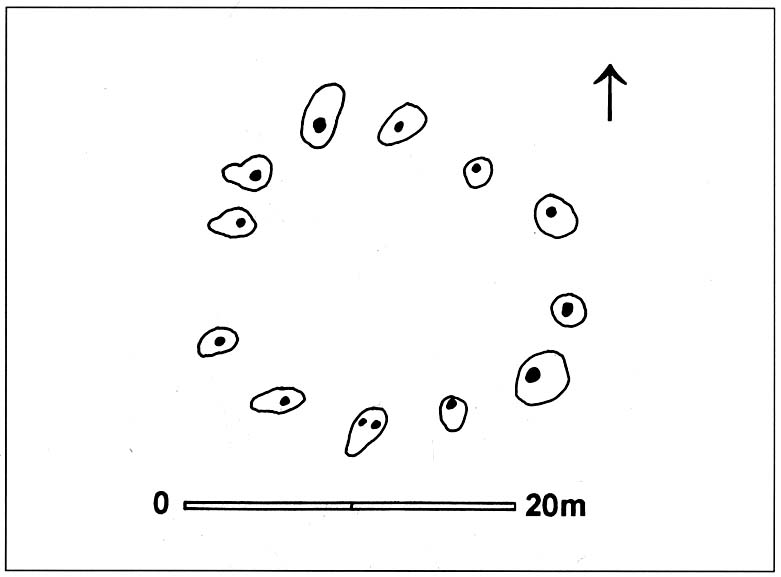
“it consisted of a ring of large pits enclosing an area some 18m in diameter.  The site was situated along the central axis of the (Dorchester) cursus, presumably influenced by the alignment.  The pits, which varied in size, had each contained a wooden post, in three instances consisting of an entire trunk of an oak tree.  All the posts were burnt in situ, presumably during some form of destruction ceremony.”

Groundplan of site

When Alex Gibson came here a few years afterwards to re-examine the site, his work and that of Richard Bradley (1988) also found the place to have been an elliptical ‘ring’ of once-upright timber posts.  Although Gibson (1998) later gave a confused version of where the site actually was (wrong grid-refs), his brief description gave us an outline of what was once here:

“An oval of 12 postholes containing the carbonized remains of 13 posts which had been burnt prior to the placing of cremations in the upper fills of the postholes.  The SW posthole contained the remains of two posts in the same socket.  There is a possible entranceway, marked by a wider gap between posts, in the NW.”

But this last line appears to be pure speculation. I’ve not read the longer archaeological accounts of this ‘wood henge’ and adjacent sites (Bradley & Chambers, 1988; Gibson 1992), which should give greater details about the site as a whole.  The Pastscape site gives the following information:

“A pit circle comprising a sub-circular arrangement of 12 pits was excavated in the early 1980s in advance of work on the Dorchester by-pass. The site lay within the Dorchester Cursus (SU 59 NE 5), circa 400 metres northwest of its southeastern terminal. The long axis of the pit circle was the same as that of the cursus. Each of the pits had held a timber upright, and some if not all had been burnt in situ. An air photograph of the site had suggested the presence of a central pit but this feature proved to be a natural pocket of sand. Six deposits of cremated bone came from various post pipes. Other finds included a handful of potsherds, one possibly of Early Bronze Age date, some animal bone fragments, and a few flints. Radiocarbon dates from cremated bone and charcoal centred on the mid 3rd millennium BC, with one slightly later.”

References:

  1. Bradley, R. & Chambers, R., “A New Study of the Cursus Complex at Dorchester-on-Thames, in Oxford Journal of Archaeology, volume 7, 1988.
  2. Cook, Jean, “The Earliest Evidence,” in Dorchester through the Ages, Oxford University 1985.
  3. Cook, Jean & Rowley, Trevor (eds.), Dorchester through the Ages, Oxford University 1985.
  4. Gibson, Alex, “Possible Timber Circles at Dorchester-on-Thames,” in Oxford Journal of Archaeology, volume 11, 1992.
  5. Gibson, Alex, Stonehenge and Timber Circles, Tempus: Stroud 1998.
  6. Pennick, Nigel & Devereux, Paul, Lines on the Landscape, Hale: London 1989.

© Paul Bennett, The Northern Antiquarian


Adam’s Oak, Brierley, South Yorkshire

Legendary Tree:  OS Grid Reference – SE 4280 1015

Also Known as:

  1. Adam & Eve’s Oak
  2. Wind-gap Oak

Archaeology & History

Highlighted on the 1854 Ordnance Survey map close to the township boundary line as Adam & Eve’s Oak, between Brierley and South Kirkby, I can’t find too much about this once great tree.  However the Wakefield historian W.S. Banks (1871) told us the following:

“Upon the common at Ringston Hill grows the remarkable ‘old Adam’ oak, much decreased in size in late years.  It is an ancient and large tree measuring twenty-seven feet in girth at a yard above the ground.  The trunk is hollow and the north side is broken away.  Most of the branches are also gone.  In 1868 a very large branch was blown off by the wind; but on the southerly side are still some very vigorous limbs.”

The old oak on the 1854 map

Even when Banks wrote this he said how the tree “must be many centuries old.”  In the time of King Charles II there used to be an old inn by Adam’s Oak at the foot of Ringston Hill, where the famous highwayman, Nevison (much-loved by many Yorkshire-folk because of his Robin-Hood-like character), used to stay.  The inn was owned by one Adam Hawksworth, but was ordered “to have his sign taken down for harbouring Nevison.”

Folklore

W.S. Banks also wrote of this once great tree:

“The people at Brierley tell of Nevison the highwayman lodging in it and hiding stolen treasures in it, things which probably did not happen, though Nevison’s name is connected with Ringston Hill.”

The treasure legend may have more to do with the adjacent stone circle, as we find ‘treasure’ a common motif at such places.

References:

  1. Banks, W.S., Walks in Yorkshire: Wakefield and its Neighbourhood, Longmans, Green  Co.: London 1871.

© Paul Bennett, The Northern Antiquarian 


Druid’s Oak, Caton, Lancashire

Legendary Tree:  OS Grid Reference — SD 5297 6467

Also Known as:

  1. Caton Oak
  2. Fish Stones Oak

Getting Here

The Druid's or Caton Oak
The Druid’s or Caton Oak

Dead easy! Near the western end of Caton village, right on the edge of the main road (A683) running through the village (south-side of the road), enclosed by railings, you’ll see the remains of this ancient tree, just by the side of the stream.  Keep your eyes peeled!

Archaeology & History

The small scruffy-looking remnant of an oak standing here by the roadside in Caton village, surrounded by protective railings, is the dying remnants of the old tree, standing upon the sandstone steps which were known as the Fish Stones: a curious monument that has been listed as a protected monument by the Dept of National Heritage.  A small plaque on the side tells:

“The three semi-circular sandstone steps, shaded by the oak tree, were used in medieval times by the monks of Cockersand Abbey to display and sell fish caught from the River Lune.  The ancient oak tree, reputed to date back to the time of the druids, and the Fish Stones, have become a landmark and Symbol of Caton.”

Druid's Oak, Caton
Druid’s Oak, Caton

This was probably the local moot spot for villagers and those living in outlying farms and hills in medieval times.  No doubt a market of some sort was also once here; perhaps even an old cross, as the Fish Stones have all the appearance of some village cross steps.  I’ve found little else about this old tree, nor any folklore (but aint looked too hard if truth be had!).  There’s surely more to be said about this once sacred tree.

More sites related in folklore to druids can be found not too far away at the collapsed cairn near Bordley; the Druid’s Altar and nearby Druid’s Well on the outskirts of Bingley; the Druid’s Stone of Bungay in Suffolk and many more…

© Paul Bennett, The Northern Antiquarian