Corrymuckloch (14), Amulree, Perthshire

Cup-Marked Stone:  OS Grid Reference – NN 89253 35346
Getting Here

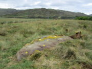
Looking to the SE

Take the A822 road to the northeast of Crieff and head 4-5 miles along until you enter the Sma’ Glen.  You go past Ossian’s Stone and after crossing the river the road starts to go uphill.  Nearly 2 miles up, the road levels out and at the left-side of the road is a small thin car-parking spot. Keep your eyes truly peeled for that!  Go through the gate and turn right (north), up the grassy slope.  Follow this footpath (known as General Wade’s road) straight past Corrymuckloch Farm until, about 250 yards on, the track splits.  Take the left track and nearly 500 yards along walk up the embankment on your left and look around (if you reach the gate you’ve gone too far).

Archaeology & History
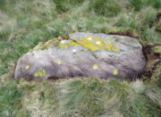
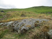
Corrymuckloch (14) stone

This stone was rediscovered in July 2023 during a cursory survey of other carvings in the Corrymuckloch cluster (17 and counting!).  Most of the stone was covered in vegetation when first found, with just a single cupmark near its crown ensuring it got more attention.  Altogether there are 10 or 11 cup-marks of varying levels of erosion across the length and breadth of the rock.  The most notable one is on the northwest side of the stone, it being twice the size of the others and of much greater depth.  It may originally have been a natural depression that was enhanced when the stone was carved.  This larger cup has a smaller one attached just above it.

An intriguing find was noted all along the western edge of the rock, where upwards of a hundred small pieces of quartz—the majority of it crystal clear—were scattered between the stone edge and the soil.  This is  an ingredient that’s been noted at a number of petroglyphs in Scotland.

© Paul BennettThe Northern Antiquarian

Corrymuckloch (2), Amulree, Perthshire

Cup-Marked Stone:  OS Grid Reference – NN 89037 34706

Getting Here

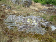
Corrymuckloch (2) stone

Take the A822 road to the northeast of Crieff and head 4-5 miles along until you enter the Sma’ Glen.  You go past Ossian’s Stone and after crossing the river the road starts to go uphill.  Nearly 2 miles up, the road levels out and at the left-side of the road is a small thin car-parking spot. Keep your eyes truly peeled for that! Walk through the gate and along the track (west) for 300 yards until you reach the fence.  Once here, walk right (north) and go through the gate less than 50 yards away.  Less than 300 yards ahead of you you’ll see a small rock outcrop.  Get to it!

Archaeology & History

Rediscovered in July 2023, on this small rock outcrop it seems that only the lower east section has been carved, and it can be pretty difficult to see beneath the old layers of lichen that’s been painted across its surface.  Comprising of just four cup-marks close to each other on the top of the stone, there’s a possible fifth cup to be seen on its northeast length.  It’s nowt special to look at to be honest, but it’s worth checking out when you’re looking at the others in this cluster.  In truth, this is another that’s only gonna be of interest to the real geeks amongst you!

© Paul BennettThe Northern Antiquarian

Briery Wood, Ilkley, West Yorkshire

Cup-and-Ring Stone (lost):  OS Grid Reference – SE 0965 4797

Archaeology & History

In Ronald Morris’ (1989) gazetteer of British petroglyphs, he included this curious entry but gave no real details regarding its appearance or history.  Listed by the Royal Commission lads, it would seem to have been located immediately south of the dismantled railway where it used to cross the Addingham-Ilkley road, but no one seems to have seen it either before or since Morris’ description.  Any help regarding its whereabouts would be appreciated.

References:

  1. Boughey, Keith & Vickerman, E.A., Prehistoric Rock Art of the West Riding, WYAS: Wakefield 2003.
  2. Morris, Ronald W.B., “The Prehistoric Rock Art of Great Britain: A Survey of All Sites Bearing Motifs more Complex than Simple Cup-marks,” in Proceedings of the Prehistoric Society, volume 55, 1989.

© Paul BennettThe Northern Antiquarian

Laighwood, Butterstone, Dunkeld, Perthshire

Cup-Marked Stone (lost):  OS Grid Reference – NO 074 458

Archaeology & History

In J. Romilly Allen’s (1882) lengthy essay on rock art in Scotland, he mentions a singular boulder that was “found by Dr Rattray” at Laighwood, near Butterstone—but, unlike him, he gave no further details regarding its appearance or exact whereabouts.  It was included in the Royal Commission (1990) survey of the area, with no additional details.  It remains lost.  In the event that you manage to rediscover it, grab some good photos of it and stick ’em on our Facebook group. (the grid-reference to this site is an approximation)

References:

  1. Allen, J. Romilly, “Notes on some Undescribed Stones with Cup Markings in Scotland,” in Proceedings of the Society of Antiquaries Scotland, volume 16, 1882.
  2. Royal Commission on the Ancient & Historical Monuments of Scotland, North-East Perth: An Archaeological Landscape, HMSO: Edinburgh 1990.

Acknowledgements:  Huge thanks for use of the Ordnance Survey map in this site profile, reproduced with the kind permission of the National Library of Scotland

© Paul BennettThe Northern Antiquarian

Chesters House, Humshaugh, Northumberland

Cup-and-Ring Stone (lost):  OS Grid Reference – NY 909 702

Archaeology & History

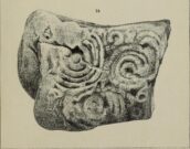
Chesters carving, 1887

The whereabouts of this carving is somewhat of a mystery.  Originally found three or four hundred yards away to the northeast of Chesters mansion, it was moved from there into the porch entranceway of the place—and here it lived for, hmmmm….well, we’re not quite sure how long it was here.  The only description of the carving seems to have been made by the Rev. G.R. Hall in 1887, and between then and sometime in the 20th century, it’s disappeared to god-knows-where.  The only known photo of the carving (right) suggests that the original design was somewhat bigger as the stone looks to have been broken off from a larger piece.  Mr Hall told us:

“this stone is 3 feet in length by 2 feet 6 inches in breadth, of irregular form.  It has five incised cups on each side of a wide, slightly curved channel, which crosses the stone at nearly its widest part.  Two other grooves intersect this longest channel, one forming a segment of a circle.  At the opposite end of the slab are two nearly parallel grooves passing towards the largest hollow. The ten cups vary from 1½ inches to 3 inches in diameter, and are from half an inch to an inch in depth.”

All being well, the carving is hiding in a wall somewhere, or maybe beneath His Lordship’s bed.  Hopefully it’ll re-appear sometime soon…

References:

  1. Beckensall, Stan, Northumberland’s Prehistoric Rock Carvings – A Mystery Explained, Pendulum: Rothbury 1983.
  2. Hall, G.R., “On Some Cup-incised Stones, found in an Ancient British Burial-mound at Pitlands Hills, near Birtley, North Tynedale,” in Archaeologia Aeliana (2nd Series) volume 12, 1887.

© Paul BennettThe Northern Antiquarian


Mountain Farm, Whittingham, Northumberland

Cup-and-Ring Stone (lost):  OS Grid Reference – NU 053 128

Archaeology & History

This lost carving may have been brought to light as a result of field ploughing which, quite fortunately, uncovered a Bronze Age burial site with a cup-and-ring stone therein.  It was reported by the regional historian David Dixon (1895) in his classic work on this area, although his description was brief and he made no sketch of the design.  He told us:

“A stone-lined grave or cist, similar to that discovered at Mile, was found several years ago on Mountain Farm, in or near to which was a sandstone slab, covered with a fine example of the incised circles, such as are found in the rocks at Routin Lynn, Bewick Hill, Chatton Law and Lordenshaws Camp.”

These other petroglyphs he mentions are bloody impressive!  Sadly they’re not yet on TNA. (site profiles required of them are considerable in size – if anyone would like to write them 😉 )

References:

  1. Beckensall, Stan, Northumberland’s Prehistoric Rock Carvings – A Mystery Explained, Pendulum: Rothbury 1983.
  2. Dixon, David D., Whittingham Vale, Northumberland, Robert Redpath: Newcastle-upon-Tyne 1895.

© Paul BennettThe Northern Antiquarian

Lour Fort, Drumelzier, Peeblesshire

Cup-Marked Stone (lost): OS Grid Reference – NT 179 356

Archaeology & History

In Sir George Douglas’ (1899) brief sketch of prehistoric remains in Peeeblesshire, he described coming across a petroglyph somewhere near the top of the Iron Age hillfort east of Stobo Castle, near Drumelzier (King Arthur country).  He told that,

“on a flat stone lying on the slope of the fort at Lour, are two “cups,” measuring 2¾ inches in diameter and an inch in depth, and exhibiting perfect symmetry in their form and position on the stone: they have been thought to be genuine examples of “rock-markings”.”

The carving hasn’t been seen since and it’s presumed that vegetation has covered the stone. (the grid-reference for this site is an approximation)

References:

  1. Douglas, Sir George, A History of the Border Counties: Roxburgh, Selkirk, Peebles, W. Blackwood: Edinburgh 1899.

© Paul BennettThe Northern Antiquarian

Whitelaw, Kirknewton, Northumberland

Cup-and-Ring Stone (lost):  OS Grid Reference – NT 942 295

Also Known as:

  1. Whitelaw Stone

Archaeology & History

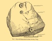
Sometime at the end of the 1860s, a local man—Mr William Wightman of Wooler—was in possession of this impressive-looking petroglyph which, we presume, he uncovered.  The carved stone was, as we can see, broken off from a larger piece and so it’s very evident that this was originally a larger design than the one illustrated here in Mr Middlemass’ (1872) drawing.  The only information we have about it are from his short notes,

The Whitelaw Stone

“was found on the north side of a hill called Whitelaw, the next eminence south-east from Yeavering Bell.  The stone is a very hard gritty sandstone, and bears distinctly the tool marks by which the circles have been cut. The tool must have been of iron or bronze, as the material is too hard to be operated upon by stone implements; moreover, the tool marks shew that the instrument used had a sharp round point, and must have been held in a similar way to the modern chisel.  The marks shew the size of the point.  The object of the artist evidently has been to fill the stone with ornament as between the two great circles; and at the corners he has placed smaller circles to suit the space. The similar nature of the circles on all the stones hitherto figured would seem to show that such stones, if monumental, were not legendary, but, most probably of a religious character; serving, like the Christian cross, to invite the traveller to pay his devotions on a spot rendered sacred by the emblems of worship.”

Searches for this have been made by Stan Beckensall (1983) and his acolytes, but it remains lost. (the grid-ref is an approximation)

References:

  1. Beckensall, Stan, Northumberland’s Prehistoric Rock Carvings – A Mystery Explained, Pendulum: Rothbury 1983.
  2. Middlemass. Robert, “On an Inscribed Stone in the Possession of Mr William Wightman, Bank, Wooler,” in History Berwickshire Naturalists Club, volume 6, 1869-72.

© Paul BennettThe Northern Antiquarian

Tom Tallon’s Grave, Kirknewton, Northumberland

Tumulus (destroyed):  OS Grid Reference – NT 9323 2800

Also Known as:

  1. Auld Wife’s Apronful o’ Stanes
  2. Tom Tallon’s Tumulus

Archaeology & History

Site on the 1866 OS-map

Highlighted on the earliest OS-maps about half a mile to the south of the great prehistoric camp of Yeavering Bell and 100 yards southwest of Tom Tallon’s Crag, there once stood an apparently “massive” Bronze Age tumulus, or cairn, called Tom Tallon.  I’d hedge a bet that it was much older, from the neolithic period.  It was described by P.A. Graham (1921) as “the largest cairn in the district,” but when it was visited by the antiquarian Henry MacLauchlan in July 1858, he reported that “it was being removed to make a fence”!!!  Unbe-fuckin’-lievable… Who were the dickheads that did that?!

Folklore

The Ordnance Survey Name Book of 1860 for Tom Tallon’s Crag told that,

“There is a vague tradition about Tom Tallon having been a Warrior and Slain here – hence the name, but nothing authentic respecting Tom, can now be ascertained.”

The word tom derives from “a rounded hill”, sometimes associated with a tumulus and in Scotland (just over the border) associated “with a dwelling place of the fairies” with tallon suggested by Graham (1921) to derive from “tal, a forehead or promontory, and Llan, an enclosure.”

What is quite obviously an older name, or certainly one that was more recognised by local people, is its title of the Auld Wife’s Apronful of Stones: a title we find associated with a number of the giant cairns in northern England and Scotland.  It relates to the creation myth of the site, whereby the countless stones that made up the cairn were dropped or thrown across the landscape by a giantess who inhabited this area.

References:

  1. Hall, James, A Guide to Glendale, M. Brand: Wooler 1887.
  2. Graham, P. Anderson, Highways and Byways in Northumbria, MacMillan: London 1921.
  3. MacLauchlan, Henry, “Notes on Camps in the Parishes of Branxton, Carham, Ford, Kirknewton and Wooller, in Northumberland,” in History Berwickshire Naturalists Club, volume 24, 1922.

© Paul BennettThe Northern Antiquarian

Soonhope, Peebles, Peeblesshire

Cup-and-Ring Stone (lost): OS Grid Reference – NT 269 419

Also Known as:

  1. Kittlegairy Burn

Archaeology & History

Fred Coles’ 1898 sketch

An apparently isolated cup-and-ring stone was found on the hills north of Peebles at the end of the 19th century by the renowned Scottish megalith explorer, Fred Coles. (1899)  He was having a look at some of the hillforts in the area and—as some of us tend to do—he began meandering off-track, down streams, through bogs and as a result came across the carving that’s illustrated here.  It’s subsequently become “lost” in the hills, but it shouldn’t be too difficult to locate, as the description he gave of its whereabouts is a pretty good one.  He told us:

“A very little over one mile and a quarter up the valley, measuring from the road at Kerfield Cottage, a tiny rivulet called Kittlegairy Burn trickles down from the SE into the main stream.  On the hill to its east, and about 450 feet higher, are the remains of a fort, one of a series of three crowning prominent heights along this side of the valley.  Down the main stream from Kittlegairy Burn is a large ruined sheep-shelter called Soonhope.  Nearly midway between these two points a deep curve has been hollowed out of the E. bank; and, at the foot of this rather high gravel bank, half immersed in the stream, lies the block of stone with the cup-and ring-marks.  They were discovered, 14th September 1896, by my daughter, Helen, on crossing the stream; and we at once proceeded to make a measured drawing, a reproduction of which is given here….  The depth of the rings in proportion to their width is the one most noticeable feature; next, the extreme thinness of the intervening ‘neck’; but, on a minute and careful examination of the nature of the stone itself, taking into consideration that its angularity and sharpness of edge and the absence of moss or even of confervoid growths on its surfaces went against the possibility of its being truly waterworn.”

The rock had obviously fallen from its original position above the burn.  Today, the entire area where this stone exists has been covered by a huge forestry plantation, but if any rock art fanatics from the Peebles area get bored one day and have nothing to do…..

References:

  1. Coles, Fred, “Notices of the Discovery of a Cist and Urns at Juniper Green, and of a Cist at the Cunninghar, Tillicoultry, and of some Undescribed Cup-marked Stones’, in Proceedings Society Antiquaries, Scotland, volume 33, 1899.
  2. Morris, Ronald W.B., “The Cup-and-Ring and Similar Early Sculptures of Scotland; Part 2 – The Rest of Scotland except Kintyre,” in Transactions of the Ancient Monuments Society, volume 16, 1969.
  3. Morris, Ronald W.B., “The cup-and-ring marks and similar sculptures of Scotland: a survey of the southern Counties – part 2,” in Proceedings of the Society of Antiquaries, Scotland, volume 100, 1969.
  4. Morris, Ronald W.B., The Prehistoric Rock Art of Southern Scotland, BAR: Oxford 1981.

© Paul BennettThe Northern Antiquarian