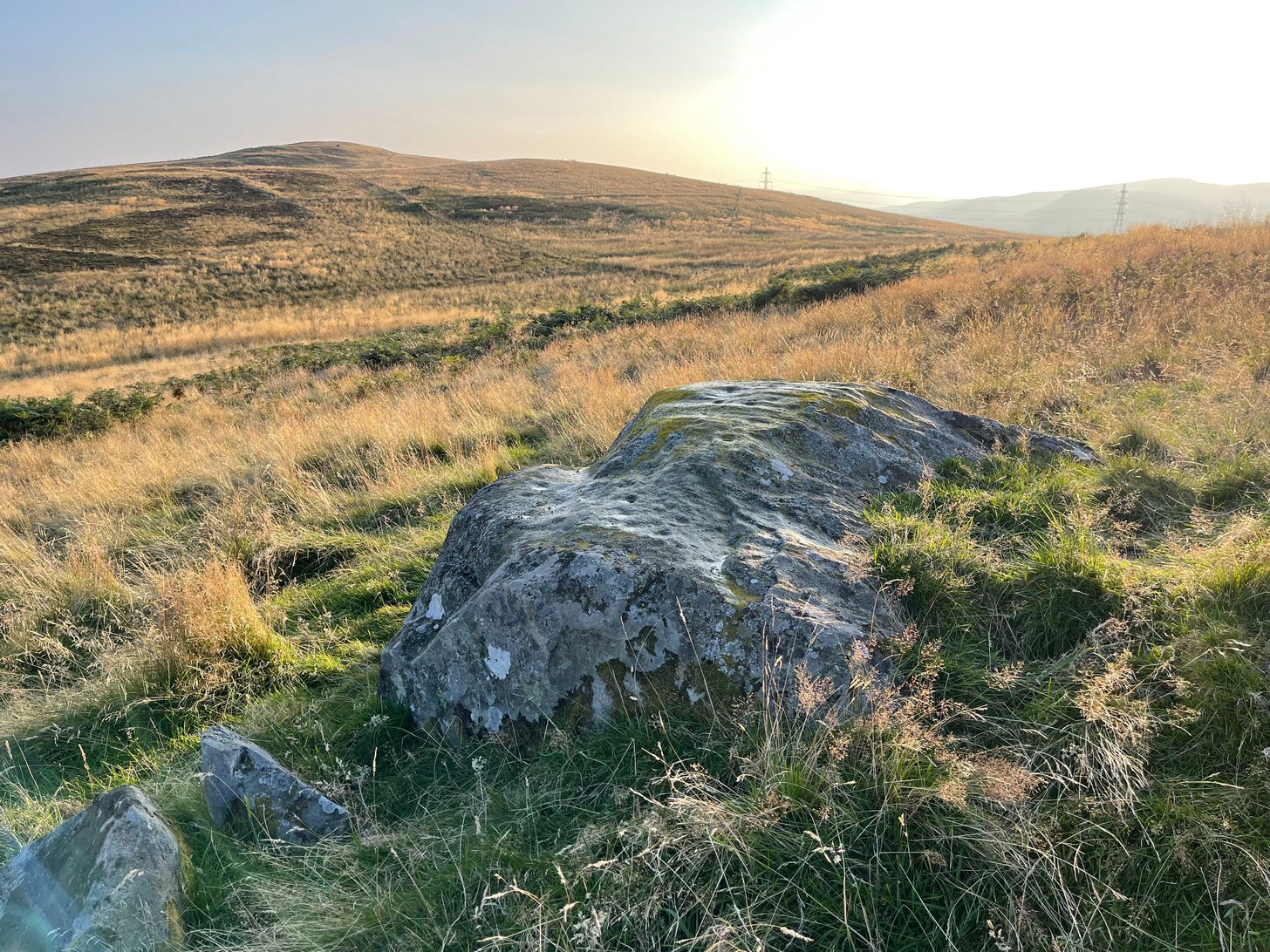
Take the same direction as if you’re visiting the Ardoch (2) carving, starting from the Foulford golf course on the A822, roughly halfway between Gilmerton and the entrance to the Sma’ Glen. From here, take the track eastwards into the hills and literally ¾-mile along you reach the pylon; keep going along the same track for another 200 yards and on your left watch out for the track-cum-footpath going up the slope past Ardoch (2), onto the hilltop, then through the gate and down the path northeast for about ⅔-mile until you reach the burn. Keep going uphill for 80 yards and through the cronky gate, head 70 yards to your left to the large single rounded boulder.
Archaeology & History
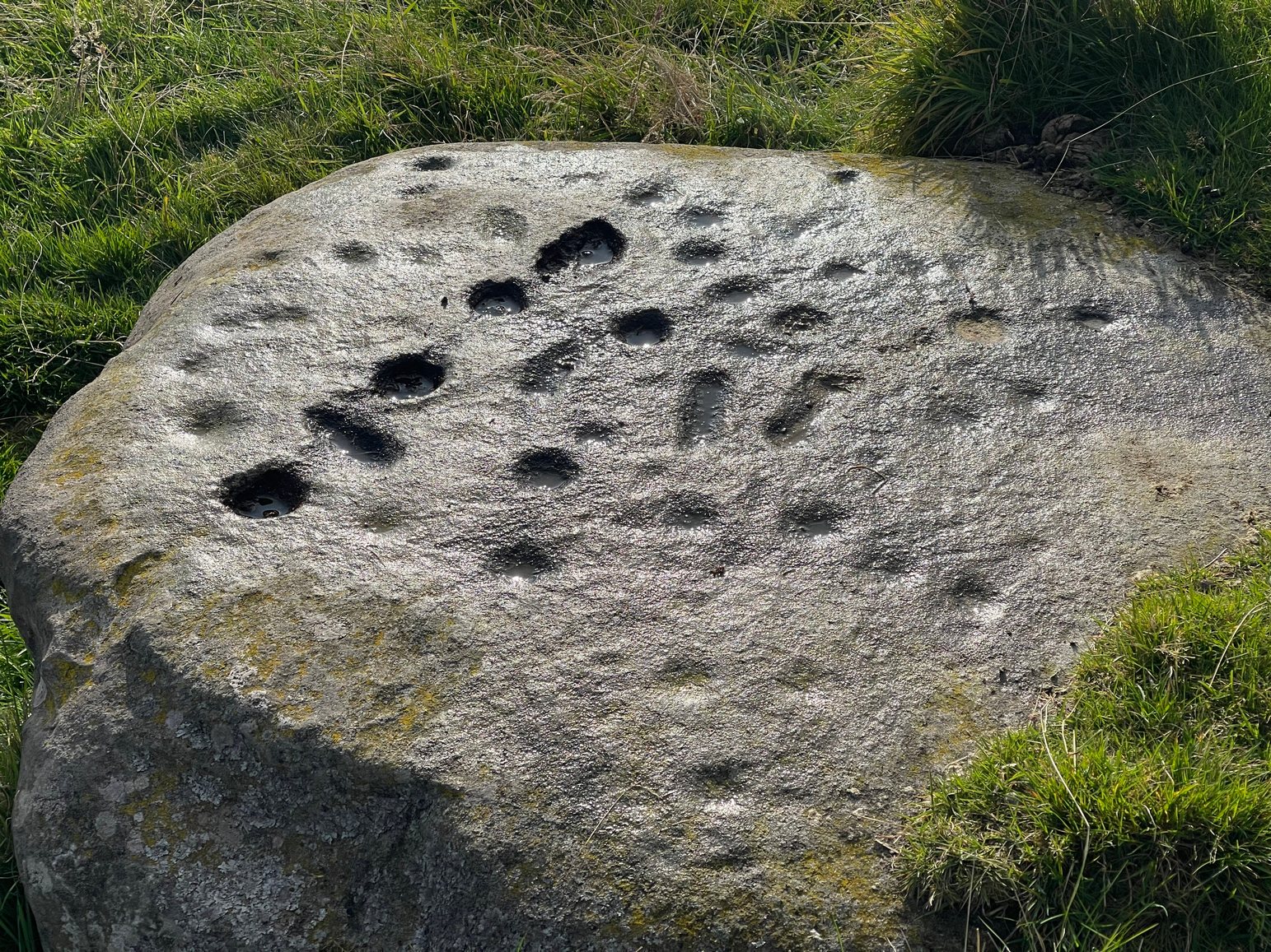
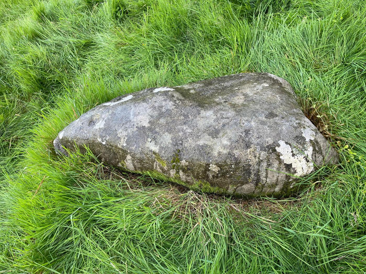
Main scatter of cups
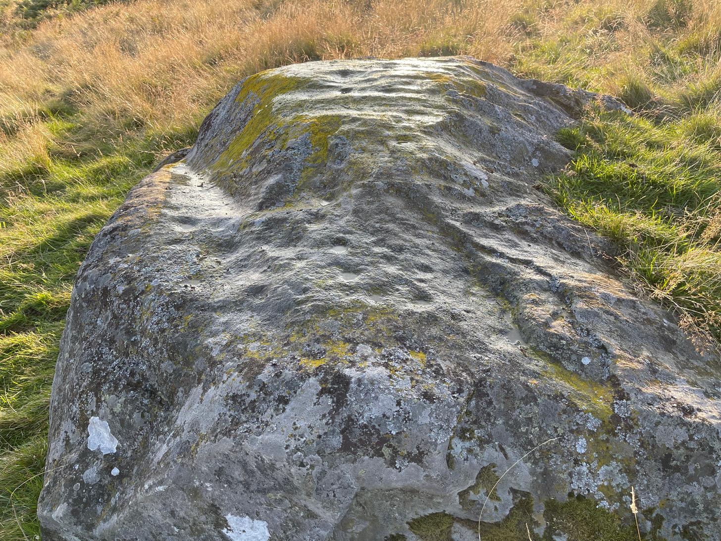
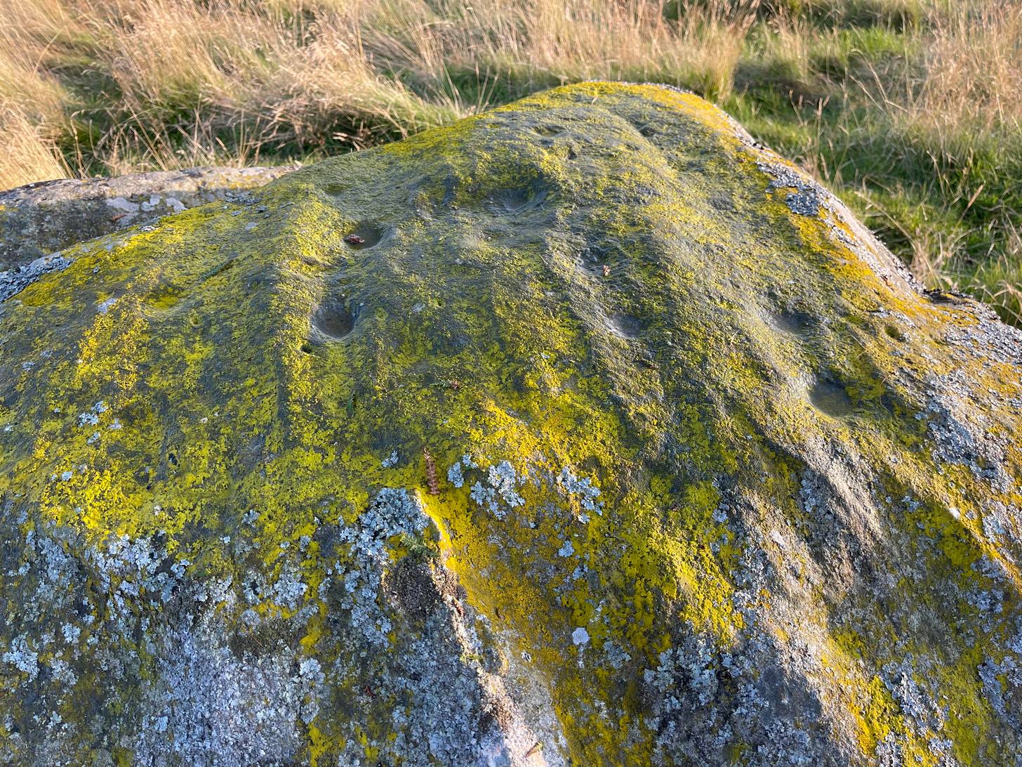
One of several petroglyphs in the area, this is the most notable in terms of its size. It rests just below the two Stroness hut circles which sit on the small level piece of ground nearly 100 yards further up the slope. A considerable scatter of cup-marks cover much of the upper surface of the boulder, some faint, some not so faint, with a number of them painted in a slight cover of lichens at the topmost section of the rock. The carving was first described somewhat blandly by George Currie (2004), who simply wrote:
“Large boulder, 2 x 2m, just W of hut circles; 16+ cups, 40–50 x 14–20mm.”
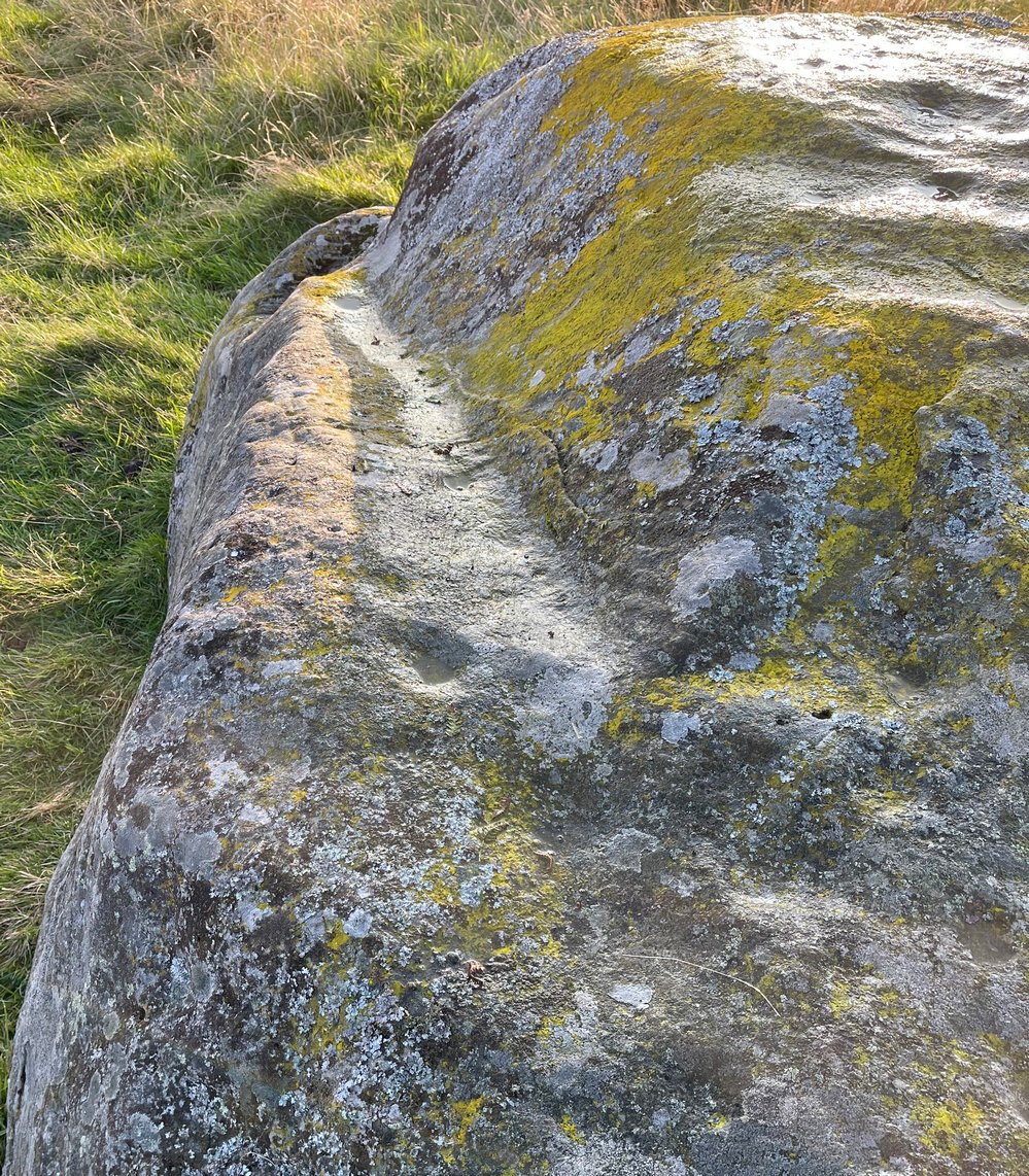
Faint line near the edgeCups among the lichens
It’s actually south of the hut circles; and there are certainly more than sixteen cup-marks, as the photos here indicate. At the time of my visit here recently, the sun was falling and was just below the level that permitted a perfect highlighting of the cup-marks, but there seemed to be at least 25 of them, scattered in no particular order over much of its upper surface. One curiosity that seemed apparent was a long carved line running along a long slender edge along on the southern side of the stone, from a large cup-mark down to near the southwestern edge, meeting another smaller cupmark. I not 100% certain that it’s actually been carved and it may just be one of Nature’s scratches along the rock, but it does seem to have that “man-made” stamp on it. Another visit in differing light will show us one way or the other.
References:
Currie, George, ‘Buchanty Hill (Fowlis Wester parish): Cup-marked Rocks’, in Discovery & Excavation Scotland, volume 5, 2004.
Stone Circle (destroyed): OS Grid Reference – NN 88808 19823
Archaeology & History
In 1995, an aerial survey done in this neck o’ the woods found a number of distinct shadows in the landscape showing a considerable number of unrecorded prehistoric archaeological sites. One of them indicated a previously unrecognized “four poster” stone circle. It was described briefly on Canmore as follows:
“The four-poster is visible (as) a square setting 6m across. It is situated between the cropmarks of a palisaded settlement…and a possible enclosed settlement.”
No excavation has yet been performed. A very clear ring ditch was also discovered some 50 yards to the east in the same field.
Folklore
There is no known folklore or traditions relating to this site or immediate locale.
References:
Burl, Aubrey, Four Posters: Bronze Age Stone Circles of Western Europe, BAR 195: Oxford 1988.
Ardoch (2) carving, with Milquhanzie hillfort behind
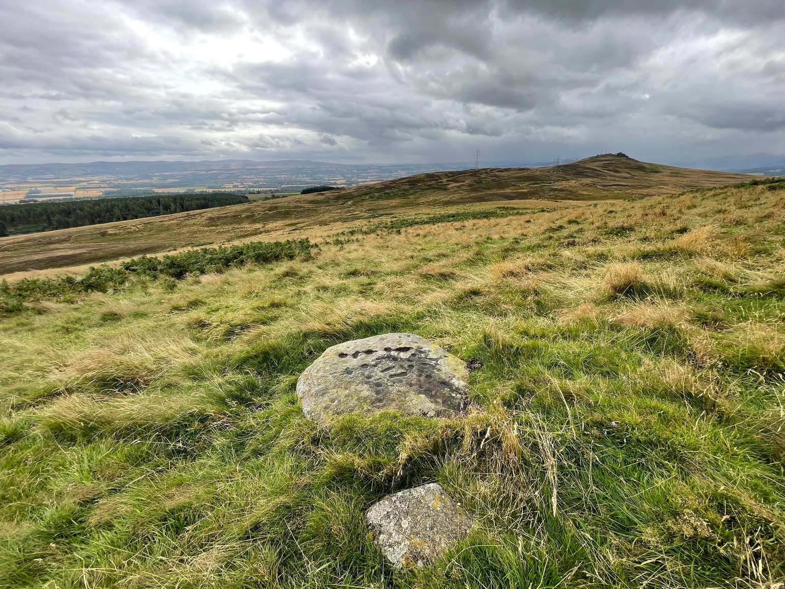
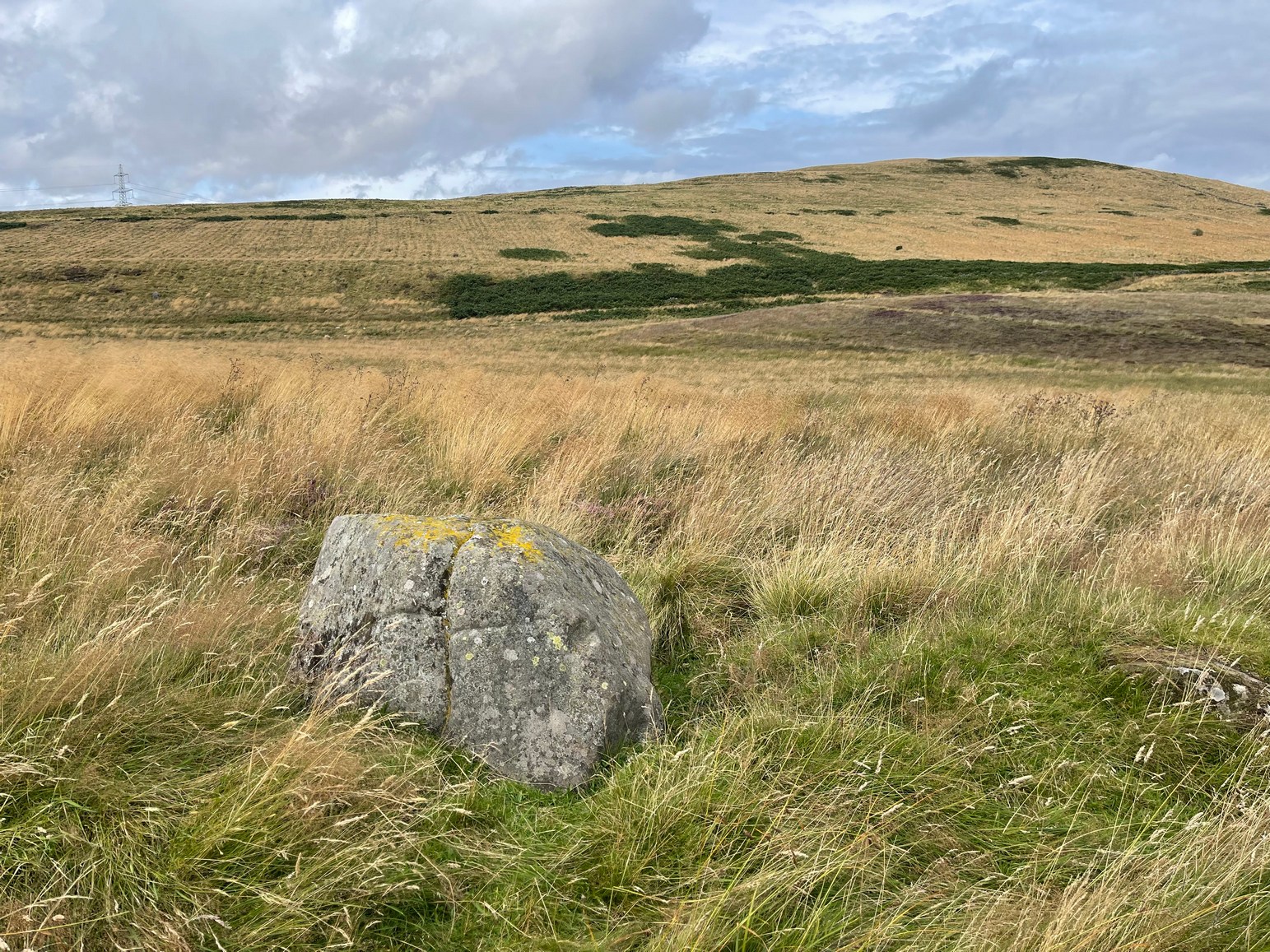
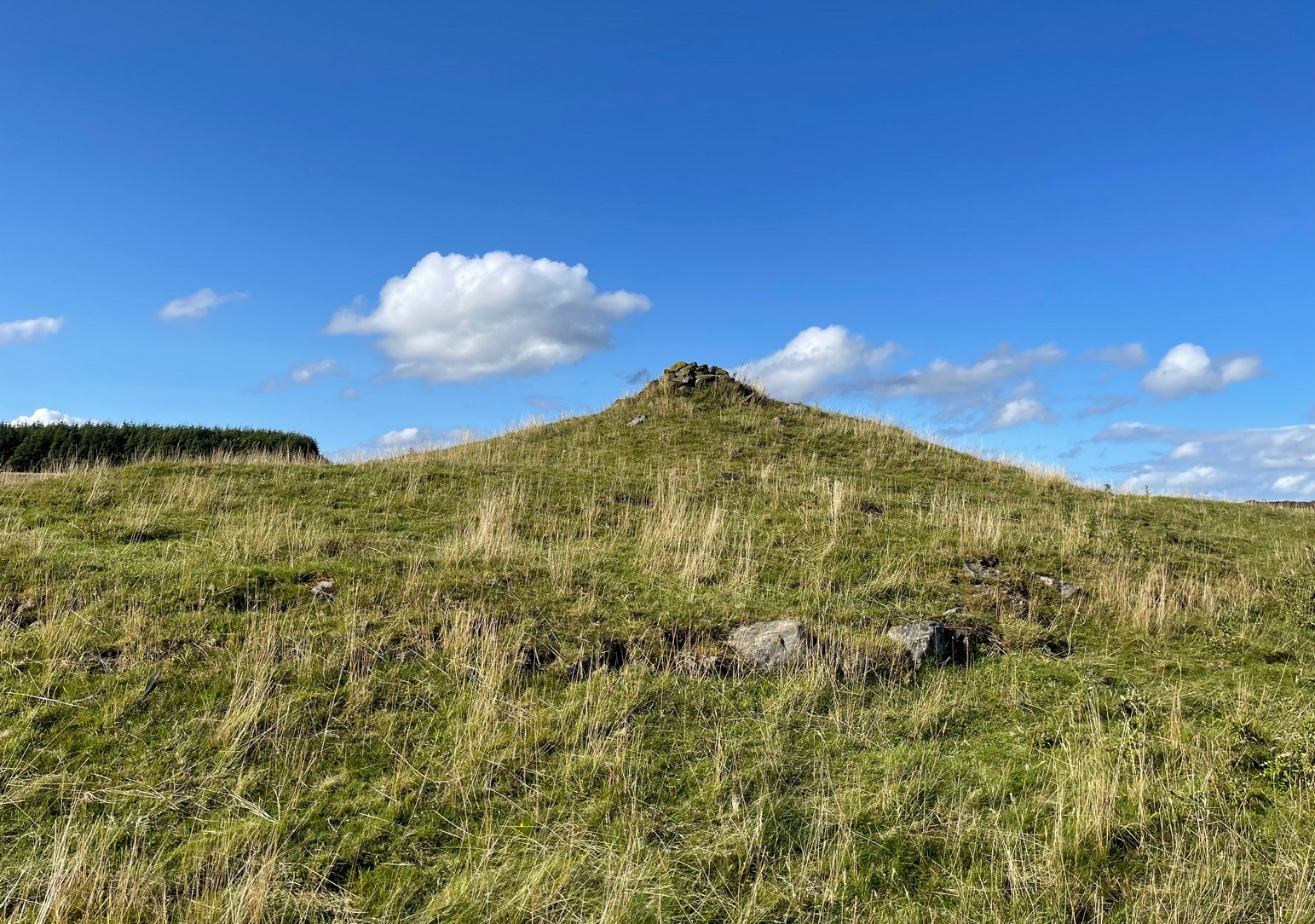
We took the long route to get here, via Fowlis Wester village, up to the car-park near the standing stones, then walk for 1¾ miles along the track: past the stones, veering right to go downhill then uphill, past the Ardoch (1) petroglyph and bearing right at the next split in the track, then right again at the next split. Then, crossing a small burn and curving round the next bend, keep your eyes peeled for the track-cum-footpath that reaches uphill on your right (NE). A shorter route is via the Foulford golf course (found along the A822 roughly halfway between Gilmerton and the entrance to the Sma’ Glen): take the track from there, eastwards into the hills, and literally ¾-mile along you reach the pylon; keep walking along the track for another 200 yards and on your left watch out for the same track-cum-footpath. Walk up there for about 400 yards and, 35 yards to the right of the fence, you’ll see a large flat stone.
Archaeology & History
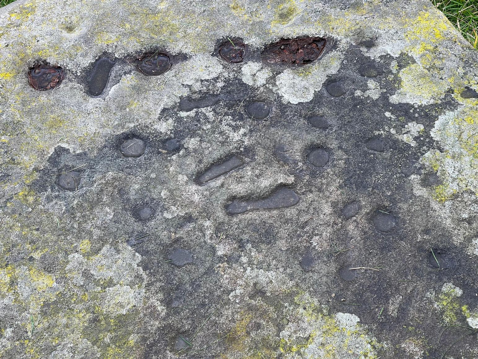
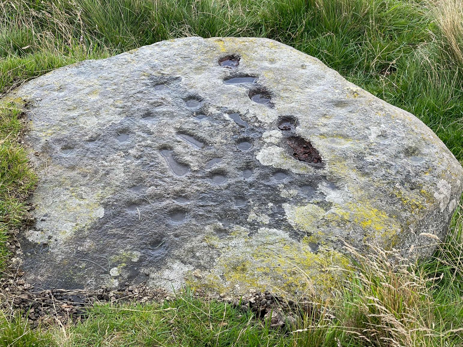
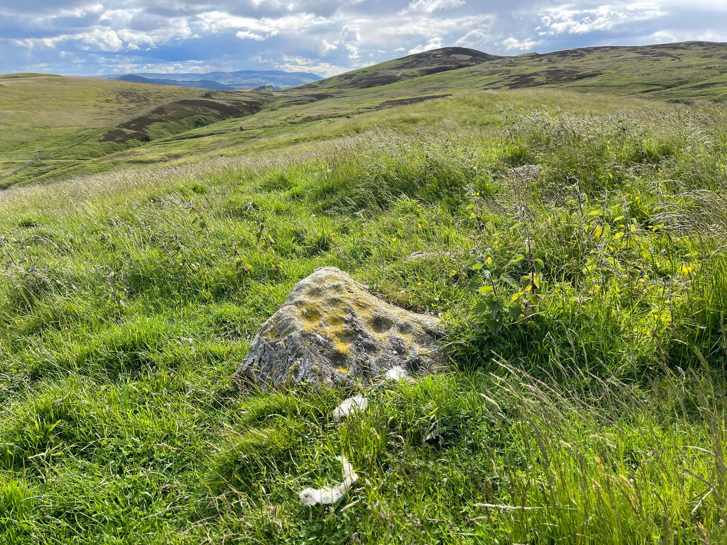
This is a most curious design, sitting way up near the top of this unnamed hill on its western face. It’s curious as there are number of odd elongated cup-marks which, to me at least, should be described as footprints. We find such designs on a few carvings (such as the one at Dunadd, and St. Columba’s Stone, etc), but they’re pretty rare. The best can be found on the Cochno Stone a few miles north of Glasgow, with additional toes on the design… but that’s for another site profile – and an essay, perhaps, should I ever get round to writing it! Anyhow…
It was first described, albeit briefly, by a Mr Comrie in 1972, who told us that,
“On a south-west facing slope of Buchanty Hill at 950ft is a boulder measuring 1.60m x 1.40m with 22 cups and 11 dumb-bells, 6 of which are distorted by a fault of quartz in the stone.”
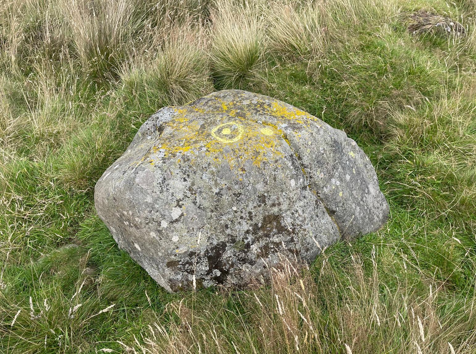
Central “footprints”“Footprints” & cup-marks
But his description of what he saw as eleven “dumb-bells” is somewhat extravagant. Six, perhaps seven would seem the more probable. I was hoping to find that the Scottish Rock Art Project doods might have spent some of their million quid in doing a computer enhancement of this carving in order to confirm it one way or the other, but this was one of hundreds that they never looked at. Very poor… (and they only described two so-called dumb-bells here!) The only other mention I’ve found of the place is in Finlayson’s (2010) fine survey of local megaliths, but only in passing.
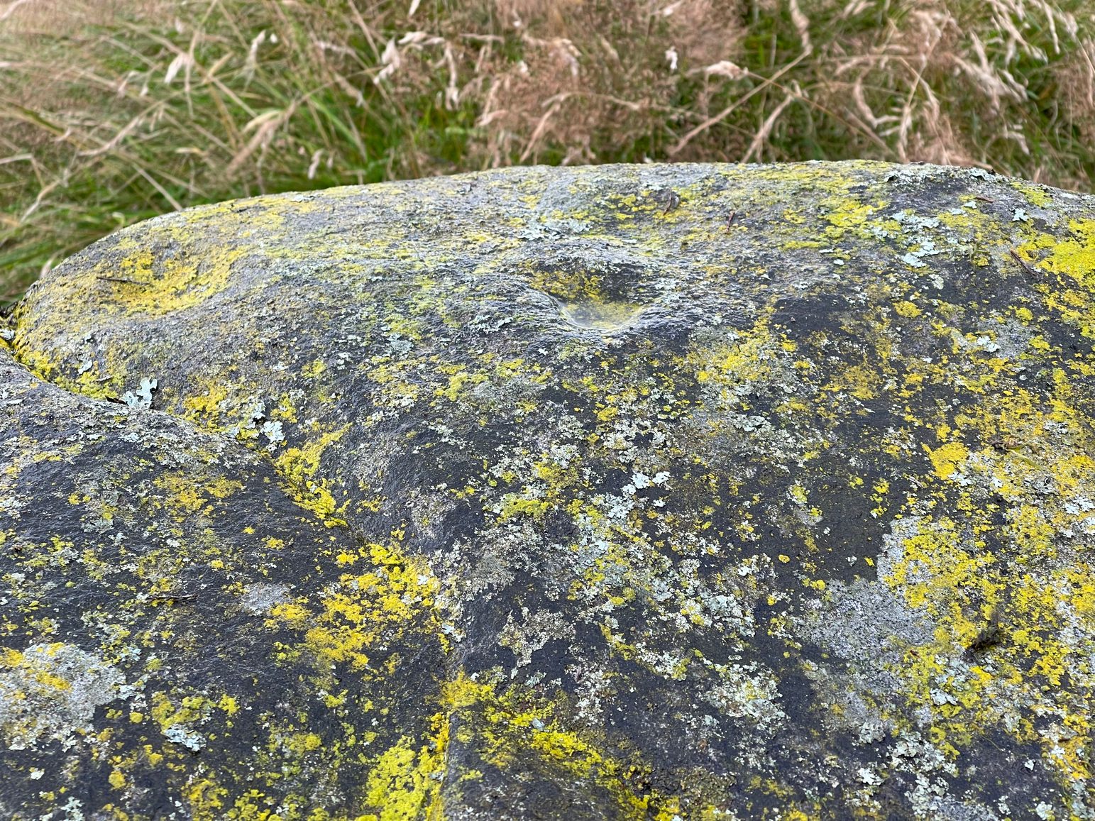
The dumb-bells or “footprints” on this carving are small: fairy footprints, one might say. The main ones are seen near the middle of the stone on its flat smooth surface. Another—perhaps two—occur along a curious geological cut that runs in a straight line, north-south (roughly) over the rock. This curious line has a series of deeply cut elements, mainly cup-marks, which give the impression of being enhanced or worked upon in much more recent centuries, looking almost as if they possessed some utilitarian function. They’re most odd and are certainly much younger than the very worn cup-marks that are scattered across the stone in no particular order. One of them seems to have a very faint ring around it. You can just make it out in one of the photos.
Looking southeastA nice close-up
So we’re looking at a multi-period carving done (probably) over several centuries. Some of the cup-marks are barely visible unless the light is just right. On my first visit here, the day was grey and overcast and some elements of the design were all but invisible; but on my second visit, one a beautiful evening, then wetting the rock, it shone out in all its splendour…. Well – as good as could be expected considering it may be five thousand years old! But the footprints are the stand-out features of the design.
In a lengthy essay on this motif that’s found on numerous European petroglyphs, Miroslav Verner (1973) points out several traditional and theoretical meanings ascribed to the symbol, which may be relevant to the stone here. The footprints may mark the rock as a pilgrimage site; or a representation of the location of a theophany, or genius loci. In some places it can be a signature of the so-called artist; or a symbol of victory; and even a symbol which possesses the power to cure fevers and other ailments. This latter tradition was known to have been practiced at the mightily impressive Blarnaboard (3) carving near Aberfoyle.
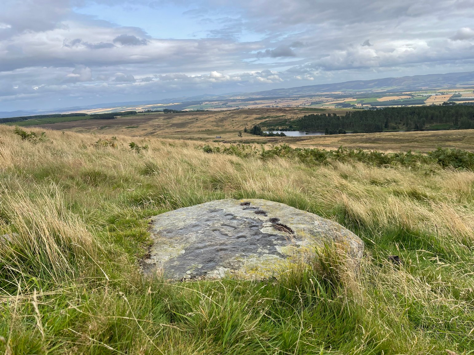
Another important feature of this carving its position in the landscape: more than a thousand feet above sea level, you sit here and the vista ahead of you reaches far far away into the distance from east to south to west. The skies above and around it are open and seemingly endless from here. It’s impressive and, most likely, these attributes are mythically significant to its meaning. Have a look at the place: take a day out and sit here for a while and get your own impression of the place. You’ll like it…
From Fowlis Wester village, head up the road for just over ½ a mile (veering sharp left at a junction) to the dusty car-park on the left-side of the road near the standing stones. From here walk along the track, past the standing stones, veering right to go downhill and cross the burn by the loch near the ruins of Ardoch house; then keeping uphill on the track for another half-mile or so and, just before a split in the dirt-track, you’ll see a reasonably large rounded boulder just a few yards above the track on your right. Y’ can’t really miss it!
Archaeology & History
This previously unrecorded cup-and-ring carving was rediscovered a few years ago by local lady Fiona McLaren: an absolute fount of knowledge when it comes to ancient sites in this area. It’s a pretty basic carving but is certainly worth looking at on your way up to see the much more unusual petroglyph of Ardoch (2).
The cup&ring highlightedClose-up of the cup&ring
When we visited this stone for the first time recently, the design was difficult to make out due to the grey overcast skies. The first thing you’ll notice is the single cup-marking on the left-side (west) of a natural crack near the top of the rock. It’s pretty easy to make out. But the cup-and-ring immediately left of this is much harder to see—or at least is was when we came here! But spend a bit of time with it, adjusting your sight, wetting the stone and, slowly but surely, you’ll notice the shallow ring surrounding another smaller cup-mark. You can make it out in the photo. A possible smaller cup-mark on the sloping northern face seems more likely to have Nature’s signature on it.
Acknowledgements: Huge thanks to Fiona McLaren of Abercairney for first uncovering this carving and pointing us towards it.
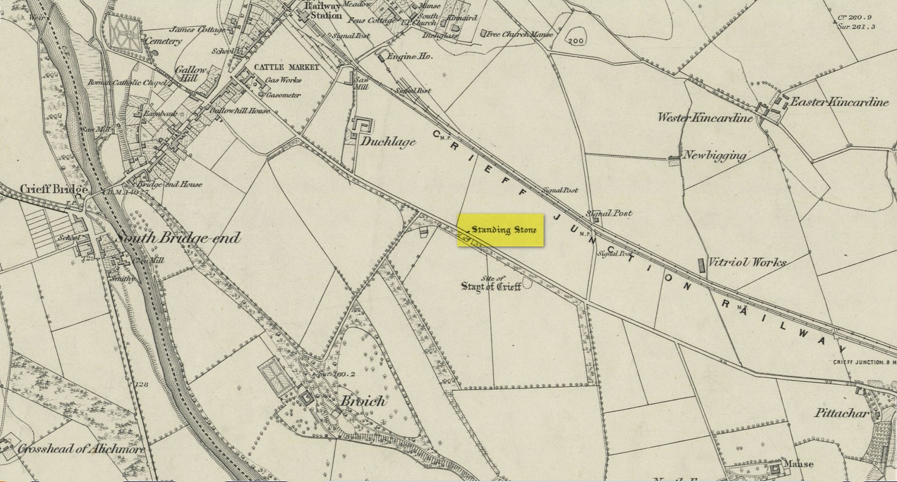
Standing Stone (destroyed): OS Grid Reference – NN 8655 2079
Archaeology & History
Site on the 1866 map
There is seemingly no trace left of this once impressive tall, slender standing stone that had lived for thousands of years on the south-side of Crieff. It was destroyed by some retard in the middle of the 20th century (anyone know their name?). Highlighted on the 1866 Ordnance Survey map of the area, it was visited and described by the late great Fred Coles (1911) when it still stood at the side of the road. He told that it was,
“In shape a narrow rhomboid at the base, this Stone rises to an acute angle at a height of 6 feet. Its longer axis is E.S.E. 52° by W.N.W. 52°, and in basal girth it measures 8 feet 11 inches.”
Coles’ 1911 sketch
Some 200 yards to the south-east there used to be the curiously-named Stayt of Crieff burial mound which had been used as a court hill for many centuries. This outlying standing stone may have been the “witness” on which oaths were sworn before the court. Sadly the history of the Stayt of Crieff mound is also somewhat sparse and it too has, appallingly, been destroyed. The destruction of these antiquities and their ancient traditions is nothing short of a fucking disgrace.
Finlayson, Andrew, The Stones of Strathearn, One Tree Island: Comrie 2010.
Acknowledgements:Huge thanks for use of the Ordnance Survey map in this site profile, reproduced with the kind permission of the National Library of Scotland.
Cup-and-Ring Stone (lost): OS Grid Reference – NT 482 214
Also Known as:
Blackcastle Hill
Getting Here
Archaeology & History
Despite there being a number of references to this carving, it would seem to have been lost. First described by James Elliot (1967) in the Discovery & Excavation journal , albeit briefly, he told that,
“A cup-marked stone which was found on this farm several years ago, has been recently identified as a “cup within a cup” type. (It was) retained by finder.”
But there was some initial confusion about its general whereabouts when Ron Morris (1967) gave a brief note of what seemed to be an additional carving in the same edition of the 1967 journal, telling us that at nearly Blackcastle Hill there existed the following:
“Small gritstone boulder, truncated-cone-shaped, having on its top surface a “cup-and-ring”, composed of a “saucer” 4½in diameter, within its centre a much deeper and clearly defined “cup”, 2in diameter. Depth 1¼in. Now removed for safety by J. W. Elliot to Whinfield Sawmill yard, Whinfield Road, Selkirk.”
As it turned out, both Elliot and Morris’s separate entries were talking about the same stone. Morris subsequently clarified this when he came to describe the petroglyph in his survey of Southern Scotland. (1981) He reported then that the carving was “beside the house’s porch in the sawmill’s yard” — but it hasn’t been seen since. Does anyone know what’s become of it, or where it might be? If you happen to find it, see if you can get a good photo or two and let us know on our Facebook group.
References:
Elliot, James W., “Synton-Mossend, near Ashkirk: Cup-Marked Stone,” in Discovery & Excavation, Scotland, 1967.
Morris, Ronald W.B., “Blackcastle Hill: Cup Marks,” in Discovery & Excavation, Scotland, 1967.
Morris, Ronald W.B., “The Cup-and-Ring and Similar Early Sculptures of Scotland; Part 2 – The Rest of Scotland except Kintyre,” in Transactions of the Ancient Monuments Society, volume 16, 1969.
Morris, Ronald W.B., The Prehistoric Rock Art of Southern Scotland, BAR: Oxford 1981.
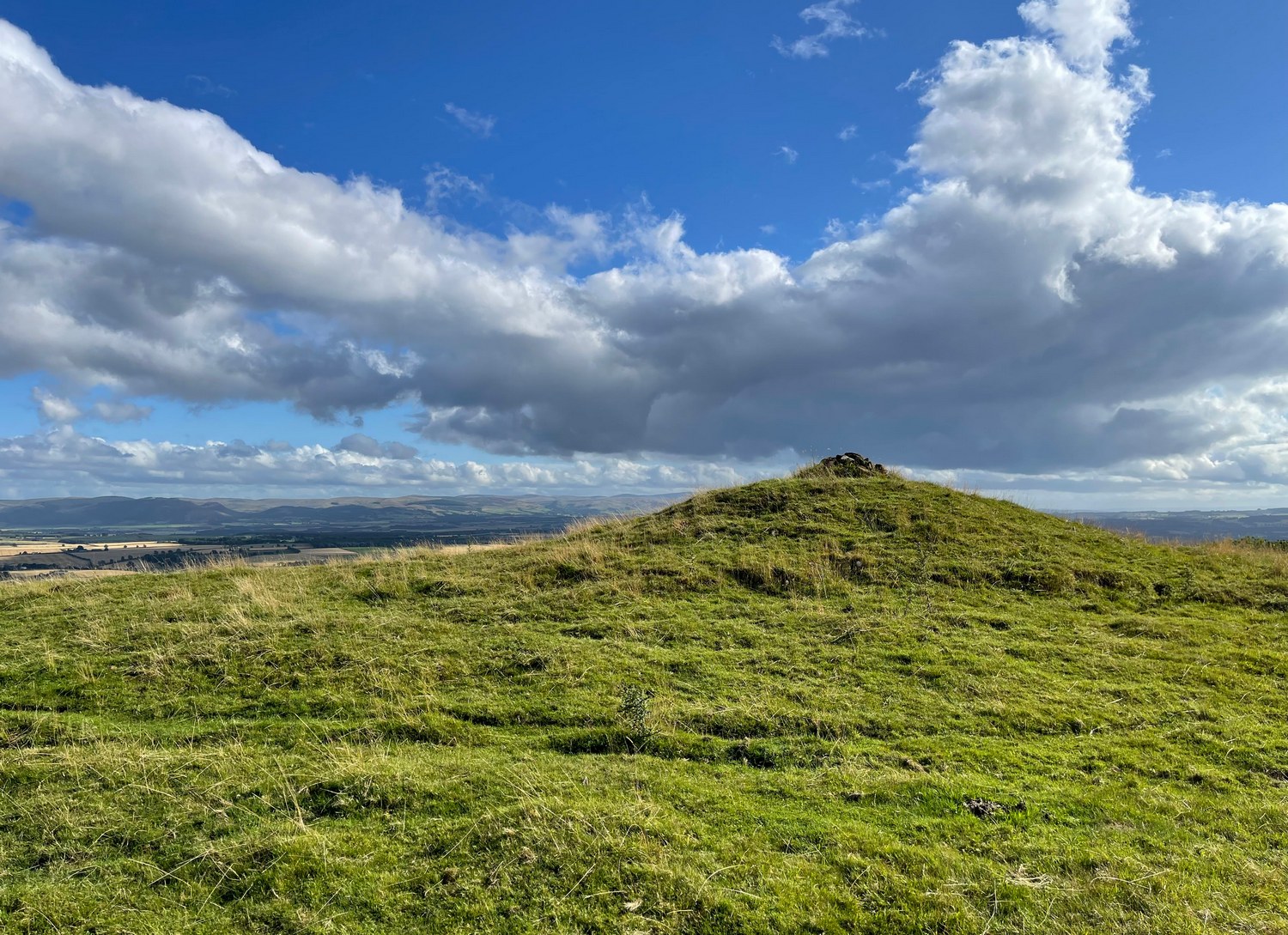
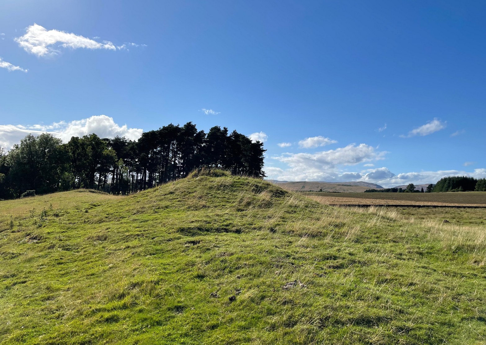
You need to hit the village of Fowlis Wester, which is easiest to approach from both east and west along the A85, between Crieff and Perth: nearly 3 miles east of Gilmerton and about 6½ mile west of Methven. Keep your eyes peeled and take the road up (north) where the large rounded tree-covered tumulus stands and up to the village. Go through the village and uphill for literally ½ a mile (veering sharp left at a junction) where a gate on your right leads into the fields. (a large parking spot is 300 yards further uphill) Walk ¼-mile east and through the other side of the small woodland, over the fence, you’ll see the mound of a typical tumulus. That’s it!
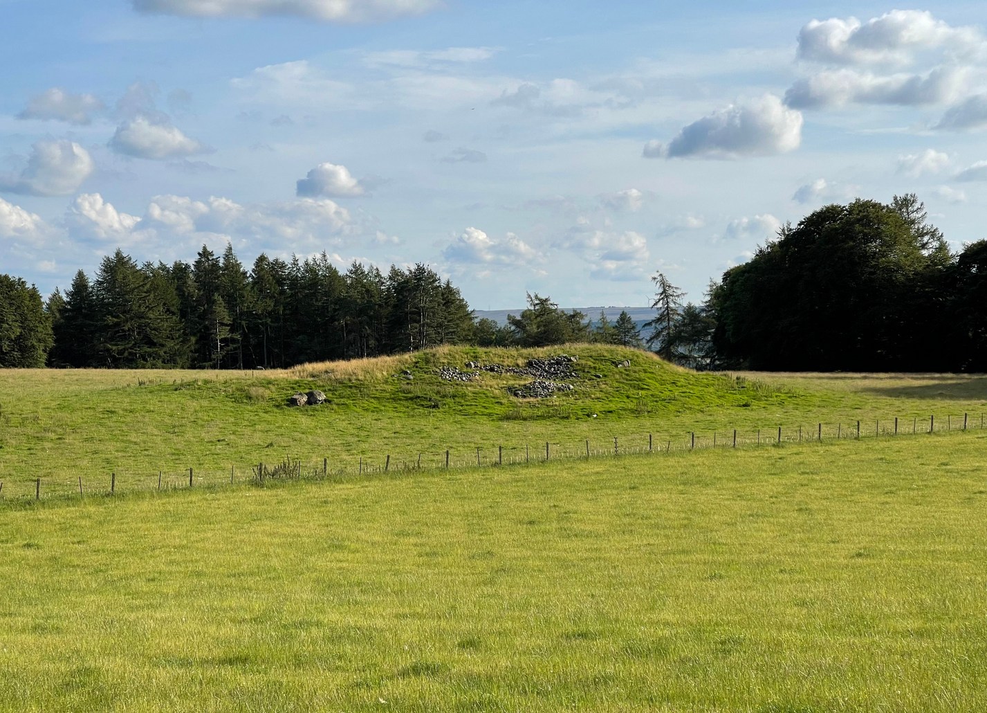
Archaeology & History
If you’re going to visit the megalithic remains of Fowlis Wester ¾-miles to the west, the antiquarians amongst you might as well give this old burial mound your attention too. It’s not grandiose by any means, but its position in the landscape is quite superb. It’s built upon a long geological promontory with extensive views that reach from south-east to south to south-west for many miles into the distance with the Ochils framing the majority of the southern horizon, but also with the notable pap of the West Lomond hill 20 miles to the south-east mimicking the shape of the tomb itself. It was obviously built here with the extended landscape having some ancestral importance. Visit it and see for yourself!
Despite being a notable mound, this tumulus-cum-cairn only seems to have been written about for the first time as recently as 1998, when archaeologist Ian Armit visited the site. Roughly circular in form, it’s about 12 yards across and more than six feet in height. A small pile of stones crowns the very top, placed here in much more recent times. At ground level on its northern side, an arc of low lying stones define the edge of the tomb. The stones probably continue all the way round the entire structure, but it’s overgrown by centuries of soil and vegetation and we lose sight of it as we walk round. When Mr Armit (1998) wrote about the site, he and colleague wrote:
Seat Knowe, looking NWSeat Knowe, looking north
“A grassed-over stony cairn lies on the highest point of Seat Knowe, a ridge commanding extensive views to the south. The cairn has a diameter of c.10m and is up to 2m high. A modern cairn occupies it summit. The low turf foundations of a rectilinear structure, some 6 x 8m, occupy its south flank, and thee are extensive cultivation and field system remains in the vicinity.”
Check it out! You won’t be disappointed.
Folklore
An interesting piece of relatively recent folklore about Seat Knowe, described in the Perthshire Name Book around 1862, told that,
“One of the Earls of Strathearn, desirous of having a church in the vicinity of his Castle, stood on an eminence, on which he had a summer seat, and resolved to erect it where the sun first shone, which was on the spot where it now stands.”
References:
Armit, Ian & Hall, M., “Seat Knowe (Fowlis Wester parish): Cairn,” in Discovery & Excavation Scotland, 1998.
It’s a helluva zigzag to get here. Just out of Crieff along the A85 road to Comrie, turn right up the minor road to Hosh and Glenturret Distillery. Just past the distillery, over the small river bridge, turn left and go up the tiny road for literally ⅔-mile (1.1km) and park up just before the cattle-grid. Naathen, up the slope into the trees at a diagonal behind where you’re parked, walk up and up for half-a-mile where the land levels out and you reach a gate (and my bath, in the undergrowth to your right). A track goes up above the gate (not the one through it) and bends round where, 100 yards up, you reach a gate. Go over it and look at one of the stones in front of you!
Archaeology & History
Very faint cups
This is another one of those petroglyphs that only the purists amongst you will want to see. On the lower section of this typically smooth female stone, you’ll see a singular cup-mark, half-natural half-carved, a couple of inches across, with a less discernible cup-mark of similar dimensions further up the rock, but entirely man-made. When we visited here yesterday, the shadows of the trees above made it very difficult to get any decent photos of the cups. Give it your eye on the journey up to the impressive standing stone of Stonefield a few hundred yards further up the hill; and if you manage to get any good photos, stick ’em on our Facebook group.
Cup-Marked Stone: OS Grid Reference – NN 8515 2484
Archaeology & History
Site of supposed cupmark
There’s little to see here. In the 1990s, students from the Royal Commission found what they described as “a single cupmark”, 3 inches across by 1 inch deep, on a rock measuring 2-feet by 1½ feet, on the north side of this large (seemingly) natural mound with large scatters of field clearance stones all over its northern face. When I visited the place yesterday (on my way to see the impressive Stonefield monolith 260 yards to the north-east), I zigzagged back and forth over the rocky mound and was unable to find it, although it may have been beneath the summer vegetation. A winter visit may prove more fruitful.
You’re going from Crieff, up the A822 road from the Gilmerton junction and head up towards the Sma’ Glen. And if you’re visiting this stone, you’ve already walked past the carvings of Connachan (2), (4), (5) and (6). So just another 100 yards or so up the dirt-track past Connachan (4), (5) and (6), just where there’s a bend in the track, the land just about levels out (if you’ve reached the gate and fence you’ve gone too far). At this point walk onto the grassland on your right for barely 50 yards, just where the land sweeps back downhill. Look around for a small stone at the edge of some very low indistinct walling. You’ll find it!
Archaeology & History
Cluster of cups
A site that’s shown on the modern OS-map as a “cairn” but which is, by the look of things, actually a hut circle — and a somewhat indistinct hut circle at that! You could very easily walk right through it without even noticing you’d done so. However, the cup-marked stone on the outer edge of its southern wall does grab your attention! Once you’ve found the stone, if you pace round a few times you’ll begin to see the vague outline of this prehistoric, probably Bronze Age abode.
at a slightly different angle
The carving was probably placed here after the hut circle had been built; or perhaps even built deliberately upon the petroglyph itself—but only an excavation would give us the answer. Its incorporation in the hut circle was probably functional, somewhat like the Man Stone carving in North Yorkshire, which is found at the doorway there. But this site is in such a state of neglect (and is somewhat overgrown) that I couldn’t ascertain whether it was at the entrance or not. If it was, then most likely there was a mythic relationship between the design of the cups and the person who lived therein. This relationship was probably a long standing traditional one attached to a particular family, or tribal leader, or even a shaman figure which no doubt stretched over many centuries. (as seems likely with the aforementioned Man Stone)
The carving itself is somewhat basic, as you can see, comprising of a small irregular cluster of between 18 and 20 tightly packed cups on a small stone. The hut circle is about 14 yards across. About 100 yards to the east is a severely robbed-out cairn.
References:
Stewart, Margaret E.C., “Connachan, Crieff – Cup Marks and Hut Circle,” in Discovery & Excavation, Scotland, 1967.