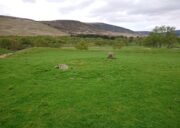
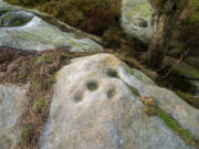
Harelawside, Grantshouse, Berwickshire

Cup-and-Ring Stone (removed): OS Grid Reference – NT 807 659

Archaeology & History

A carving that no longer exists in its place of origin, but can now be seen in the National Museum of Antiquities in Edinburgh.  It was discovered by a Mr James Craw (1931), who gave us the following account of his find:

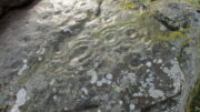
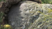
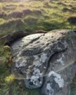
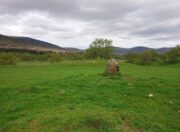
“In 1910 my attention was attracted by some markings on a boulder on the top of a field wall, ¼-mile NNW of Grant’s House church and at an elevation of some 550 feet above sea level.  The stone was a rounded and somewhat flattened slab of greenstone, measuring 22 inches by 17 inches by 4 inches… It bore a small cup ½-inch in diameter, surrounded by two rings of shallow incision, the outer being 3 inches in diameter.  From the cup a duct, partly natural, led across the stone, and another cup, without rings, had also a short duct.  Adjacent to these markings was a curious grid design of shallow lines, a series of parallel lines ¼-inch apart, being crossed at right angles by lines 2½ inches apart.”
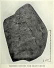
1930 photo of the carving

Across a section of the stone there may also be a curving pecked line which Craw didn’t appear to notice.  The parallel lines would appear to have quite separate origins, with those running below the cup-and-ring seeming to be ancient, whereas the others have the appearance of being cut with metal tools and seem much more like modern scarring.

Shortly after finding the stone, Mr Craw took the petroglyph to the National Museum in Edinburgh, where he was told that they didn’t think it “as being of early workmanship, the cups and rings being of much smaller proportions than the typical markings of the Bronze Age and the grid design having no known parallel.”  They were wrong on both accounts of course, although I for one still remained unconvinced by one set of parallel lines that run along to the edge of the stone.  That said, there are similar carvings of parallel lines at the impressive Traprain Law 15 miles northwest of here, so I may be wrong.

The wall in which this carving was found was obviously not its place of origin.  It most likely came from one of the cairns that was reported by J. Hardy to have been destroyed in this field in 1882.

References:

  1. Craw, James H., “An Inscribed Boulder from Grants House,” in History of Berwickshire Naturalists Club, volume 27, 1931.
  2. Edwards, Arthur J.H., “Rock Sculpturings on Traprain Law,” in Proceedings Society of Antiquaries, Scotland, volume 69, 1935.
  3. Morris, Ronald W.B., “The Cup-and-Ring and Similar Early Sculptures of Scotland; Part 2 – The Rest of Scotland except Kintyre,” in Transactions of the Ancient Monuments Society, volume 16, 1969.
  4. Morris, Ronald W.B., “The cup-and-ring marks and similar sculptures of Scotland: a survey of the southern Counties – part 2,” in Proceedings of the Society of Antiquaries, Scotland, volume 100, 1969.
  5. Morris, Ronald W.B., The Prehistoric Rock Art of Southern Scotland, BAR: Oxford 1981.

© Paul BennettThe Northern Antiquarian

Kirktonhill, Channelkirk, Berwickshire

Stone Circle (destroyed):  OS Grid Reference – NT 474 548

Archaeology & History

Included in Aubrey Burl’s (1976) first gazetteer, without comment, the site was subsequently added to John Barnatt’s (1989) magnum opus.  He tells that in the 19th century, “early Ordnance Survey records…note a destroyed stone circle” here, but draws a somewhat sceptical opinion of its very existence as “the Ordnance Survey frequently made mistaken interpretations in the 19th century and hence this should be treated with caution.”

Despite this, early local historians refer to the site, albeit in the past tense.  The first would seem to have been Walter Elliot (1869) in his address to the respected Berwickshire Naturalists Club.  Some members of this group had visited a number of ancient sites the previous year:

“A camp above Channel Kirk was also indicated, near which a stone circle formerly existed, but it has been destroyed and the materials used for building dykes within the last five or six years.”

The “camp” was an old Roman one which has itself been almost completely destroyed, despite it still being shown on modern OS-maps.

The circle was mentioned in passing in Mr Thomson’s (1902) huge work on his descriptions of the many local hillforts.  Close to one at Kirktonhill known as the Roman or Agricola’s Camp, “forty years ago, there was said to have been a stone circle.”  This was reiterated in Craw’s (1920) survey of prehistoric monuments in Berwickshire.

Perhaps the most curious omission is in Mr Allan’s (1900) huge survey on Channelkirk parish.  His description of the Roman camp was considerable, but he made no mention of an adjoining circle.  The best we got from him was a vague allusion about some ancient pre-christian site not far from the church, when he wrote:

“Whether or not some rude form of a place of worship might then exist on the spot where now a church has stood for so long it were rash to assert, but there are certain indications that some particular place, specially marked as consecrated to religious rites, was then a local possession.”

(it should be noted that the Canmore entry for this site has its location at the prehistoric camp due west of Kirktonhill, which is incorrect)

References:

  1. Allan, Archibald, History of Channelkirk, J. Thin: Edinburgh 1900.
  2. Barnatt, John, Stone Circles of Britain – volume 2, BAR: Oxford 1989.
  3. Burl, Aubrey, The Stone Circles of British Isles, Yale University Press 1976.
  4. Burl, Aubrey, The Stone Circles of Britain, Ireland and Brittany, Yale University Press 2000.
  5. Craw, J H., “Early types of burial in Berwickshire“, in History Berwickshire Naturalists Club, volume 24, 1920.
  6. Elliot, Walter, “Anniversary Address Delivered at Berwick on the 30th of September, 1869,” in History Berwickshire Naturalists Club, volume 6, 1869-72.
  7. Thomson, A., Lauder and Lauderdale, Craighead Brothers: Galashiels 1902.

© Paul BennettThe Northern Antiquarian

Drumderg (2), Tullymurdoch, Perthshire

Cup-and-Ring Stone:  OS Grid Reference – NO 18523 54950

Getting Here

Drumderg (2) cup-and-ring

Two ways: i) up the A93 road from Blairgowrie, after 5 miles turn right at the Bridge of Cally and up Glen Shee.  After another 3½ miles, keep your eyes peeled for the tiny road on the right signposted to the Drumturk Cheese farmshop.  Go up this long tiny winding road for a mile up to the cheese place and keep on this road for another 2¼ miles where you can park up near the entrance to the huge wind-farm; or – (ii) from Alyth, go up the long winding tiny Bamff Road and keep to the signposts for Bridge of Cally Glen Shee until, after about 4 miles, you reach the entrance to the windfarm.  Walk up the track to the windmills, bearing right at the first junction, then right again at the next one.  From here, shortly before the second windmill, walk down into the moor for nearly 200 yards. It’s quite a large stone.

Archaeology & History

Interlocking rings close-up

This is impressive.  Very impressive!  Found within a huge mass of other prehistoric sites in the Forest of Alyth, its only known petroglyphic bedfellows—Drumderg (1) nearly 500 yards yards south, and Drumderg (3) 120 yards north—have nothing on this one!  Where the others have basic cupmarks, this bears a series of multiple interlocking cup-and-ring designs, some with one ring, others with two, and one with four, albeit incomplete rings.

The design is etched onto the sloping face of a curved triangular ‘female’ stone.  An eroded cutting all but separates the two main components of the design, but this cut has within it a distinct singular cup-and-ring almost linking each side together.  On one side (which is near the middle of the stone) we have a complex series of multiple cup-and-rings that seem to be sequentially moving and (almost) growing into each other in some form of organic pattern.  The bottom of this growth begins from a standard cup-and-ring and runs immediately into a vulva-like slit of a cup-mark surrounded by four incomplete rings.  As the photos show, this keeps climbing upwards.

Cupmarks on its W-side
Looking into the setting sun

A more simplistic basic design has been etched onto the more western side of the stone, on the other side of the eroded cutting.  Two of the cup-marks have rings around them, with one of them seeming to give birth to another upward “growth”, but this time comprising merely of a line of more cups, curving ever-so-gently towards the middle of the stone.  Along with this there are also cup-marks on the top ridge of the stone; faint carved lines curve and intersect.  Movement seems embedded in this fixed non-linear design.  That’s my impression anyhow!

The only literary attention given to the carving seems to have been by the Scottish Royal Commission (1990) lads in one of their Perthshire inventories.  It’s simple as always, telling basically,

“this heavily weathered cup-and-ring marked boulder lies 150m south of the hut circles… The carvings are on the southwest face of the boulder and comprise: at least four cups surrounded by single rings; two cups surrounded by triple rings; an oval cup measuring 100mm by 70mm surrounded by four rings; and twenty-two plain cups marks, the largest 60mm in diameter.”

If there’s anything extra that we should puzzle over, it’s this: why do we have such an intricate carving here, living in near isolation in the midst of countless other prehistoric remains?  The answer, most likely, is that it’s not alone.  I highly suspect that others are waiting to be found up here beneath the endless ocean of heather…

References:

  1. Royal Commission on the Ancient & Historical Monuments of Scotland, North-East Perth: An Archaeological Landscape, HMSO: Edinburgh 1990.

© Paul Bennett, The Northern Antiquarian
Caddam, Clova, Angus

Standing Stone:  OS Grid Reference – NO 33546 72144

Getting Here

Caddam stone, looking E

The only real way to get here is via Kirriemuir.  Head north to the hamlet of Cortachy and past it, as you enter Glen Clova, where the road splits make sure you bear to the left-hand (western) side.  Nearly 5½ miles along, keep your eyes peeled on your right where you can’t really miss it.  The stone’s less than 100 yards into the field.  …It may perhaps be a bit easier if you take the eastern road of the glen all the way to Clova village.  Turn right from there, over the small river bridge and as it curves to go back down the glen, a half-mile along you pass Caddam house.  Keep going for another 500 yards and you’ll notice it in the field.

Archaeology & History

Stone and its hut circle

Not to be confused with the ruined stone circle of the same name 10 miles to the south, this small standing stone—only some three feet in height—is at the eastern edge of a small overgrown hut circle measuring some 3 yards by 4 yards across.  You can just make out the overgrown low walling in the second photo (right).  The stone probably had some architectural relationship with the hut circle, but without an excavation we can’t know for certain what that relationship might have been.  A settlement of much larger hut circles can be found on the other side of the river, near Rottal, two miles southeast of here.

© Paul BennettThe Northern Antiquarian

West Lamberkine (1), Aberdalgie, Perth, Perthshire

Cup-Marked Stone (lost):  OS Grid Reference – NO 0617 2328

Archaeology & History

Site shown on 1933 map

First highlighted on the 1933 OS-map of the area, it was located alongside the old fence-line hereby, but no subsequent description of the carving has been made since then.  A small boulder and a number of other stones can be found along the line of fencing, but none seem to be possessed of petroglyphs and apart from it being shown on the old maps, I can find no reference or description of it.  It may have been destroyed.  Some researchers have wondered if the carving was mistakenly marked at this spot by surveyors who confused it with another one more than 500 yards to the southeast (and described by Fred Coles in 1903), but this would seem an unlikely error to have been made.  Whilst this was described as a simple “cup-marked stone”, its neighbour at West Lamberkine (2) was a distinct and more complex cup-and-ring design.

References:

  1. Coles, Fred,  “Notices of …(4) of Some Hitherto Undescribed Cup-and-ring-marked Stones…” in Proceedings Society Antiquaries Scotland, volume 37, 1903.

Acknowledgements:  Many thanks for use of the Ordnance Survey map in this site profile, reproduced with the kind permission of the National Library of Scotland

© Paul BennettThe Northern Antiquarian


Mount Lodge, Portobello, Edinburgh, Midlothian

Cairn (destroyed):  OS Grid Reference – NT 3071 7366

Archaeology & History

The only reference I can find of this long lost cairn is in William Baird’s (1898) massive history work of the area—but even in his day he reported that “it has long since disappeared.”  He wrote:

“We have a curious reference in a charter of Kelso Abbey, granted about 1466, to a cairn of stones which stood near the south-east corner of the garden wall at Mount Lodge, Portobello.  In the charter, where it is referred to as forming part of the boundary of the lands of Figgate, it is described as, ‘a certain heap of stones there deposited.'”

The cairn was likely of considerable size and, said Baird, “in all probability marked the site of an ancient place of sepulture.”

References:

  1. Baird, William, Annals of Duddingston and Portobello, Andrew Elliot: Edinburgh 1898.

© Paul BennettThe Northern Antiquarian

Raven Stones (562), Thruscross, North Yorkshire

Cup-Marked Stone: OS Grid Reference – SE 1194 5810

Getting Here

The Raven stone setting

Take the A59 road from Harrogate and Skipton and at the very top of the moors keep your eyes peeled for the small Kex Ghyll Road on your left(it’s easy to miss, so be diligent!).  It goes past some disused disused quarry and after a mile or so where you hit a junction, turn left, past the Outdoor Centre of West End and straight along Whit Moor Road.  About a mile past the Outdoor Centre go left down to Brays Croft Farm and over the ford, then keeping to the footpath up to the right (west) and note the clump of trees on the moors above you to the west.  That’s where you need to be.

Archaeology & History

Several of the cupmarks

Several natural basins that might have been worked in prehistoric times are accompanied by several distinct cup-marks near the middle-edge of the stone, in a rough triangular formation, with two others slightly more eroded a little further down the same side.  Boughey and Vickerman (2003) noted several other cupmarks on the rock, some distinct, some not so.

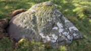
Adjacent to this carved stone is another naturally worn stone of some size, with incredibly curvaceous ripples over the top of the rock which, in all probability, possessed some animistic property to the people who carved this and other nearby carvings. Check the place out.  It’s a gorgeous setting!

References:

  1. Armstrong, Edward A., The Folklore of Birds, Collins: London 1958.
  2. Boughey, Keith & Vickerman, E.A., Prehistoric Rock Art of the West Riding, WYAS: Wakefield 2003.

© Paul BennettThe Northern Antiquarian 

Warsett Hill, Brotton, North Yorkshire

Round Barrows (destroyed):  OS Grid Reference – NZ 692 214

Archaeology & History

Tumuli shown on 1920 map

On top of the large plateau that is Warsett Hill, on the southwest side of the old trig-point, could once be seen a cluster of at least seven burial mounds or tumuli.  The mounds are shown on the first OS-map of the area, but merely as mounds.  It wasn’t until there’d been a subsequent investigation here by local historian J.C. Atkinson in the 19th century that they were highlighted on the 1920 map as “Tumuli.”  Sadly, since then, they’ve all been destroyed.

Very brief notes were written on six out of the seven tombs here by William Hornsby (1917), with only one of them receiving any real attention.  “Of the other six,” Crawford (1980) wrote,

“there is very little information; all were excavated by Atkinson prior to 1893, but his excavations revealed no finds and he stated that all of the mounds had been previously disturbed.  They were later dug by Hornsby, who stated that although he found no sepulchral deposits, all the mounds contained flints.”

In medieval times this became a beacon site, where bonfires were lit.  I can find no further information about this. (NB: This site should not to be confused with another Warsett Hill that exists two miles southeast of here above Skinningrove.)

References:

  1. Crawford, G.M., Bronze Age Burial Mounds in Cleveland, Cleveland County Council 1980.
  2. Hornsby, William & Stanton, R., “British Barrows near Brotton,” in Yorkshire Archaeological Journal, volume 24, 1917.

Acknowledgements:  Huge thanks for use of the Ordnance Survey map in this site profile, reproduced with the kind permission of the National Library of Scotland

© Paul BennettThe Northern Antiquarian

Cnoc Dubh, Moulin, Pitlochry, Perthshire

Stone Circle (destroyed):  OS Grid Reference – NN 9424 5871

Archaeology & History

Missing from the primary surveys of Burl (2000) and Barnatt (1989), a mention of this long lost site was made by local historian Hugh Mitchell (1923) in his survey of the area.  He told that,

“On the east side of the Moulin road beyond the Hydro Hotel a knoll and a clump of trees will be noticed on the right, inside the Hydropathic grounds; this knoll is known as the Cnoc Dubh, or “Black Knoll” and still bears an uncanny reputation as being an old site of Pagan worship.  There was at one time a stone circle on it, but the stones are said to have been broken up, fully 100 years ago, to build the old farmhouse of Balnadrum.”

Something ancient was there, obviously, as it was mentioned in another earlier account—albeit just a tourist guide of Atholl—which said that, on

“the knoll known as Knock-Dhu, within the (Pitlochry Hydro) grounds, are the remains of a pre-historic fort, now overgrown with pine trees.”

References:

  1. Anon., Atholl Illustrated, L. Mackay: Pitlochry c.1910.
  2. Dixon, John H., Pitlochry Past and Present, L. Mackay: Pitlochry 1925.
  3. Mitchell, H., Pitlochry and District: Its Topography, Archaeology and History, L. Mackay: Pitlochry 1923.

Links:

  1. Canmore

© Paul BennettThe Northern Antiquarian

Cairney Mount, Carluke, Lanarkshire

Standing Stone (destroyed):  OS Grid Reference – NS 855 507

Archaeology & History

The Well & the field-name on the 1860 OS-map

An ancient standing stone on the eastern side of Carluke isn’t something that most local people are aware of.  Sadly it’s long gone, but we find what seems to be a reference to it, both in the place-name Stanistone Road and the adjacent Standing Stone Well.  The monolith would seem to have stood immediately east of the well, as a description of it by Rev John Wylie (1845) in the New Statistical Account (1845) indicates.  Wylie told us that:

“Till lately, one of those remarkable monuments of antiquity, called standing stones, stood at Cairney Mount; but the hope of finding a hidden treasure induced some rude hand to destroy it.”

Cairney Mount is a field-name 300 metres east of the well, so it would seem highly likely there was an association between them, and the stone obviously stood somewhere between these two points.

References:

  1. Royal Commission on the Ancient & Historical Monuments of Scotland, Lanarkshire: An Inventory of the Prehistoric and Roman Monuments, HMSO: Edinburgh 1978.
  2. Wylie, John, “Parish of Carluke,” in New Statistical Account of Scotland – volume 6: Lanarkshire, William Blackwood: Edinburgh 1845.

© Paul BennettThe Northern Antiquarian