Balgair Moor, Fintry, Stirlingshire

Standing Stone:  OS Grid Reference – NS 60774 90383

Getting Here

Balgair Moor stone

Go up the B822 road from Fintry for literally 2.5 miles (about 500 yards below the small copse of trees that almost hide Balafark Farm above you) and at a very small ‘parking’ spot are 2 farm-gates.  Go through the lower of the two and head downhill, crossing the small burn and up the other side for just over 100 yards where you’ll meet a very low, old and very overgrown wall.  Keep your eyes peeled for it!  Walk left along this wall, uphill, for another 100 yards till you meet a a dried-up dyke that runs downhill.  10-15 yards down this, a small stone greets you…

Archaeology & History

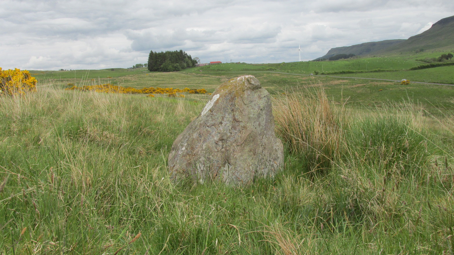
It’s difficult to call this a ‘standing stone’ and, as far as I’m concerned, is even more troublesome to cite it as a legitimate prehistoric monument.  Nevertheless it is shown on the modern OS-maps as such and was listed by the Royal Commission (1963:1) lads in their standing stones inventory.  But it’s really pushing it to be honest!  They told us:

“This stone stands about 180 yds NW of a gate which opens off the Fintry-Kippen road, 340 yds N of its crossing of the Lernock Burn.  It is triangular in profile and wedge-shaped in section, measuring 3’3″ both in height and breadth along its base, by 1’7″ in greatest thickness.  It may well have been a boundary stone as it is near the corner of some ground which is enclosed by a turf dyke and has been cultivated.”

Looking southwest
Looking up to the ancient cairn of Stronend

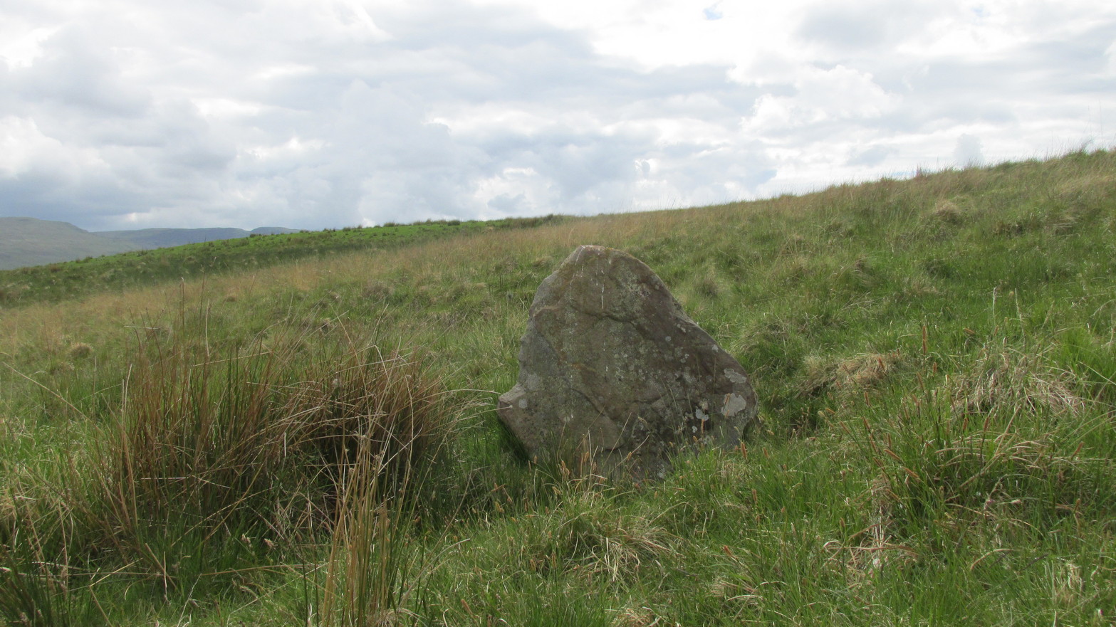
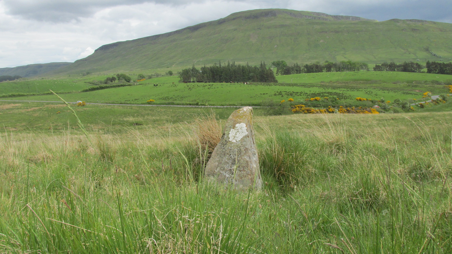
In truth, if we call this a standing stone, then there are hundreds of others that I’ve come across over the years—frobbling off-path across huge swathes of moorland—that must also be added to our prehistoric inventories, as the height of this isolated rock is echoed in countless others which are off the archaeological listings.   One such stone ‘stands’ 100 yards northeast of here—although there are many others with  much greater potential.  …I think the only thing that may sway this as being a possible prehistoric upright is the fact that the top of the stone appears to have been broken off, albeit a few hundred years ago if the weathering is owt to go by.   But a cursory look for any broken top-piece found nothing.

References:

  1. Royal Commission on the Ancient & Historical Monuments Scotland, Stirling – volume 1, HMSO: Edinburgh 1963.

© Paul BennettThe Northern Antiquarian

The map could not be loaded. Please contact the site owner.

Village Cross, Leighterton, Gloucestershire

Cross (destroyed):  OS Grid Reference – ST 824 910

Archaeology & History

Charles Pooley (1868) gave a somewhat vague description of this site, telling that, “there is authority for believing that at one time a Cross was set up in the village.”  I can find no other reference to this monument which, I presume, has been destroyed.  (the grid reference cited is an approximation near the centre of the village, where village crosses were usually located)

References:

  1. Pooley, Charles, Notes on the Old Crosses of Gloucestershire, Longmans Green: London 1868.

© Paul BennettThe Northern Antiquarian

The map could not be loaded. Please contact the site owner.

High Cross, Elkstone, Gloucestershire

Cross (destroyed):  OS Grid Reference – SO 9674 1321

Archaeology & History

High Cross on 1883 map

First shown on a 1775 map of the region, this long-lost site is preserved in several place-names near the old crossroads a half-mile north of Elkstone village.  It is mentioned, albeit briefly in Charles Pooley (1868) county survey, where he told that, “in former times a very handsome and lofty High Cross stood in this parish.”  However, there’s the possibility that the name ‘High’ cross may here derive simply from a cross located at a high point in the landscape.

An old ‘Guide Post’ marked on the early Ordnance Survey map at the same spot has been suggested by Danny Sullivan—and not without good reason—to be a prehistoric standing stone.  He may be right.

References:

  1. Pooley, Charles, Notes on the Old Crosses of Gloucestershire, Longmans Green: London 1868.
  2. Sullivan, D.P., Old Stones of the Cotswolds and the Forest of Dean, Reardon: Cheltenham 1999.

© Paul BennettThe Northern Antiquarian

The map could not be loaded. Please contact the site owner.

Churchyard Cross, St Briavel’s, Gloucestershire

Cross (destroyed):  OS Grid Reference – SO 559 047

Archaeology & History

At the church of St. Mary at the northern end of the village, Charles Pooley’s (1868) county survey told that,

“There was formerly a Cross in the churchyard near the south porch, but it was removed in the year 1830, when the new tower was built.”

It would seem there is no longer any trace of the monument.

References:

  1. Pooley, Charles, Notes on the Old Crosses of Gloucestershire, Longmans Green: London 1868.

© Paul BennettThe Northern Antiquarian

The map could not be loaded. Please contact the site owner.

Market Cross, Lechlade, Gloucestershire

Cross (destroyed):  OS Grid Reference – SU 214 995

Archaeology & History

In days of olde, Charles Pooley (1868) told us that “an old cross formerly stood in the Market-place” in the centre of the town where the old crossroads meet—as was customary for crosses and maypoles—just outside the church of St. Lawrence.  Pyramidal in form, it was mentioned in an old manuscript cited by Adin Williams (1888), which told us,

“Leland saith that in his days there was a Piramid of Stone at ye west end of ye Church, whose foundations are to be seen near Slaughter’s Well, which is said to be medicinal water.”

And although we don’t know when the cross was erected, we know when it was destroyed.  Williams again tells us:

“About 1770, Sir Jacob Wheate pulled down this cross.  He is said to have taken the stones to the house he was building.”

References:

  1. Pooley, Charles, Notes on the Old Crosses of Gloucestershire, Longmans Green: London 1868.
  2. Williams, Adin, Lechlade: Being the History of the Town, Manor and Estates, The Priory and the Church, E.W. Savory: Cirencester 1888.

© Paul BennettThe Northern Antiquarian

The map could not be loaded. Please contact the site owner.

Village Cross, Deerhurst, Gloucestershire

Cross (destroyed):  OS Grid Reference – SO 870 299

Archaeology & History

In Charles Pooley’s (1868) definitive account of Gloucestershire county crosses, he informs us that,

“there was formerly a Cross erected in this village, but it has long since disappeared.”

He gives no further information about its history, but we must surmise that it was either associated with the ancient priory on the north side of the village, or in the traditional place at the centre of the the village. The grid-reference cited places the lost cross in the grounds of the priory.

References:

  1. Pooley, Charles, Notes on the Old Crosses of Gloucestershire, Longmans Green: London 1868.

© Paul BennettThe Northern Antiquarian

The map could not be loaded. Please contact the site owner.

Churchyard Cross, Lower Dowdeswell, Gloucestershire

Cross (destroyed):  OS Grid Reference – SP 001 199

Archaeology & History

In Charles Pooley’s (1868) definitive history on the county crosses, this monument is mentioned in passing without any known history, apart form it been destroyed sometime in the early 19th century:

“A cross formerly stood in the churchyard, but it has been removed within living memory.”

References:

  1. Pooley, Charles, Notes on the Old Crosses of Gloucestershire, Longmans Green: London 1868.

© Paul BennettThe Northern Antiquarian

The map could not be loaded. Please contact the site owner.

Village Cross, Powerstock, Dorset

Cross (destroyed):  OS Grid Reference – SY 5167 9622

Archaeology & History

This old cross was almost lost to history, but thanks to personal notes written by one John Banger Russell in 1780, we’ve been left with a description of the monument, which Alfred Pope (1906) published in his survey:

“In the middle of this parish are the remains of a large cross, which has been much injured by time.  The shaft, which seems to have been of considerable height, has been taken down, tho’ the base or pediment still continues in its proper place.  The ascent was by four steps but the whole is very ruinous.”

Nearly a hundred years later in the hugely updated magnum opus of John Hutchins (1863), the site had long gone:

“A mutilated cross which stood in the centre of the village at the beginning of the present century, has since been destroyed.”

References:

  1. Hutchins, John, The History and Antiquities of the County of Dorset – volume 2, Bowyer & Nichols: London (3rd edition) 1863.
  2. Pope, Alfred, The Old Stone Crosses of Dorset, Chiswick Press: London 1906.

© Paul BennettThe Northern Antiquarian

The map could not be loaded. Please contact the site owner.

The Cross, Gussage All Saints, Dorset

Cross (destroyed):  OS Grid Reference – ST 999 108

Archaeology & History

In days of olde an old stone cross used to stand “at the crossroads just outside the churchyard,” wrote Alfred Pope (1906); but even in his day he told that “the cross has long since disappeared.”  He continued:

“The Rev A.S.B. Freer, vicar, informs the writer that the site is still known as ‘The Cross’, and is never called by any other name by the villagers.”

The church in the village is dedicated to All Saints, whose festival date was known in older times to be the pre-christian New Year’s Eve, or Halloween, when the spirits of the dead move across the landscape.

References:

  1. Pope, Alfred, The Old Stone Crosses of Dorset, Chiswick Press: London 1906.

© Paul BennettThe Northern Antiquarian

The map could not be loaded. Please contact the site owner.

St. Andrew’s Cross, Dunfermline, Fife

Cross (destroyed):  OS Grid Reference – NT 1017 8630

Also Known as:

  1. Canmore ID 50858

Archaeology & History

In Pete Chalmers (1844) historical brief about the long lost chapel and hospital of St. Leonard (and its associated holy well), mention is made of this long forgotten relic.  Its memory was preserved in an old place-name, and was to be found less than half-a-mile southeast of St. Leonard’s sites on,

“the high part of the road, about a quarter of a mile to the south, the Spital-Crosshead, (named) from a pillar which, according to tradition, was erected there, decorated on the top by a St Andrew’s Cross, and removed probably towards the close of the 16th or 17th century.”

The cross is believed to have been erected in the 15th century.

References:

  1. Chalmers, Peter, Historical and Statistical Account of Dunfermline, William Blackwood: Edinburgh 1844.

© Paul BennettThe Northern Antiquarian

The map could not be loaded. Please contact the site owner.