Standing Stone: OS Grid Reference – SE 0405 5106

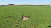
Probably the easiest way here is to take the well-trodden Dales High Way track westwards, under the bypass from Addingham, and along the old Roman Road. After 1.7 miles (2.7km) you’ll reach the Heights Lane country road. Stop here! Walk back on yourself along the track for maybe 50 yards and look in the field to your right (south) between 10-20 yards in the short grass and there, somewhere under your feet next to a modern stone, you’ll see peeking up at you (probably somewhat covered on the whole by the soil) a long flat stone. That’s what you’re looking for.
Archaeology & History
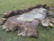
This old stone had been sought after by various groups and people for many years and I was fortunate to relocate it about thirty years ago, laid down and all-but-hidden beneath the grasses. The stone appears to have been buried nearly 100 years earlier, because when Harry Speight (1900) wrote about it in 1900 he described it as still upright. In more recent years, it seems that the farmer has put a replacement stone next to its position with the letters “JC” cut into it. You can see it in the above photo.


First mentioned in the 16th century and included in boundary perambulation records of 1709, and again in 1781, someone during that period turned it into a milestone, etching the words “To Skipton 3 m. To Addingham 2 m.” It stood by the old Roman road, but its considerable erosion and shape is decidedly prehistoric. Nearly 6 feet long, it is now laid in the earth and almost completely covered over. A sure case for resurrection.
References:
- Bennett, Paul, The Old Stones of Elmet, Capall Bann: Milverton 2001.
- Speight, Harry, Upper Wharfedale, Elliott Stock: London 1900.
© Paul Bennett, The Northern Antiquarian
The map could not be loaded. Please contact the site owner.