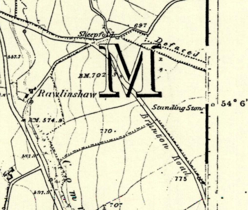
The site is usually invisible, being under the waters of Walshaw Dean Middle Reservoir. But in good droughts you can catch a glimpse of the place. So take the Widdop road as it’s known locally, from either Hebden Bridge up past Heptonstall, or from Burnley, Nelson & Colne side, and park-up by the pub a few hundred yards east of Widdop Reservoir. Walk a few hundred yards back down the road (east) and take the dirt-track on the other side of the road on the Calder-Aire link leading to the Pennine Way. Walk up past the first reservoir, keeping to its west-side, until you reach the Lodge house where the second lake appears. Now, if the water’s down, walk along its western-edge for about 50 yards, looking into the dried flat ahead of you and you’ll see the loose ring of small stones. That’s it! Or as Mr Roth described the place in 1906, “The position of the circle is on the left-hand side of the valley going up, a few yards above the dam of the second reservoir.”
Archaeology & History
Earliest photo of the circle
This is a somewhat bizarre archaeological site, whose nature we may never fully recover. Although listed and scheduled as a plain stone circle by Aubrey Burl (2000) and others, both the placement and structure of the site implies a more funerary aspect to it. This was suggested by Ling Roth (1906) when he first wrote about it. But for me, the position of the site in the landscape calls into question the archetypal ‘stone circle’ category, as it is somewhat hemmed-in both east and west, with limited views north, and only a good view of open lands to the south (summer). It’s just a bit odd when compared to other megalithic rings in the Pennines. But perhaps this ‘privacy’ was intended — as there is only scattered evidence of other human activity in this valley and on the moors above. Perhaps this site was meant to be ‘cut off’ from the rest of the world. We might never know…
There is also the peculiar addition inside this stone circle of an arc of walling facing southeast, which is unique in this part of Britain. But this walling seems to have been a later addition and has the hallmarks of being some small shelter, or even an early grouse-shooting butt (there’s tons of game-birds here, and this would be an excellent spot to shoot from) This internal wall may have been constructed from stone that came from the circle itself: perhaps in a rubble wall, perhaps an internal cairn. It seems likely. Mr H. Ling Roth (1906) also mentions this feature in what was the first description of the site, where he told:
“The stone circle at Walshaw Dean Reservoir…was discovered by Mr W. Patteson, the resident engineer, in July 1902. The circle consists of ten irregular stones apparently local rock, varying considerably in size, one measured 6ft 3in (1.9m) long and stood about 30 inches (76cm) above the clay when the peat surface was removed. Whether the stones are deeply embedded has not been ascertained, but where they were covered by the peat a clear white band is apparent. The circle is 36 feet (11 metres) is diameter and of very fair exactitude. Inside the circle as shewn on the plan and in the view there was a rouhg carved wall which measured across the ends 12ft (3.7m). The wall had been partly pulled down and reset immediately before examination by a party of visitors soon after the discovery. Its presence in the circle may be fortuitous, but after the two unsystematic disturbances to which the ground had been subjected, it is not possible to form an opinion about it. That something had been buried in the centre of the circle is probable when we bear in mind the circumstances of stone circles elsewhere, but an examination shewed only that the ground had been disturbed and Mr Patteson explained to me that such disturbance was not of recent date.”
To my knowledge, no subsequent excavation of the site has ever been done, but it would appear that the waters have washed part of the site away and any remains that may once have been found within the ring have been discarded by more than a century of erosion. Traces of small walled structures have also been noted close to the circle in recent years, suggestive of settlement remains. On a TNA outing last year, we also found previously unrecorded prehistoric remains on this hills above here. When Geoffrey Watson (1952) wrote his survey on prehistoric Calderdale, he suggested that the Walshaw Circle may have been placed alongside the branch of an early trade route running along the northern edge of the valley. Not so sure misself…
References:
Bennett, Paul, The Old Stones of Elmet, Capall Bann: Milverton 2001.
Burl, Aubrey, The Stone Circles of Britain, Ireland and Brittany, Yale University Press 2000.
Roth, H. Ling, The Yorkshire Coiners, 1767-1783; and Notes on Old and Prehistoric Halifax, F.King: Halifax 1906.
Watson, Geoffrey G., Early Man in the Halifax District, HSS: Halifax 1952.
Cairn Circle (destroyed): OS Grid Reference – NM 2721 2371
Also Known as:
Angel Hill
Cnoc nar-aimgeal
Sithean More
Archaeology & History
There have long been rumours of stone circles on the druid’s isle of Iona, but many are dismissed as little more than errors on behalf of antiquarians, or false descriptions of hut circles and settlement remains. The stone circle of Sithean Mor however, does seem to have existed until only a century or two ago. It was first mentioned by the great traveller, Thomas Pennant (1776), who visited Iona more than once. He told us:
“On my return I saw, on the right hand, on a small hill, a small circle of stones, and a little cairn in the middle, evidently druidical, but called the hill of the angels, Cnoc nar-aimgeal; from a tradition that the holy man had there a conference with those celestial beings soon after his arrival. Bishop Pocock informed me that the natives were accustomed to bring their horses to this circle at the feast of St. Michael, and to course round it. I conjecture that this usage originated from the custom of blessing the horses in the days of superstition, when the priest and the holy-water pot were called in: but in latter times the horses are still assembled, but the reason forgotten.”
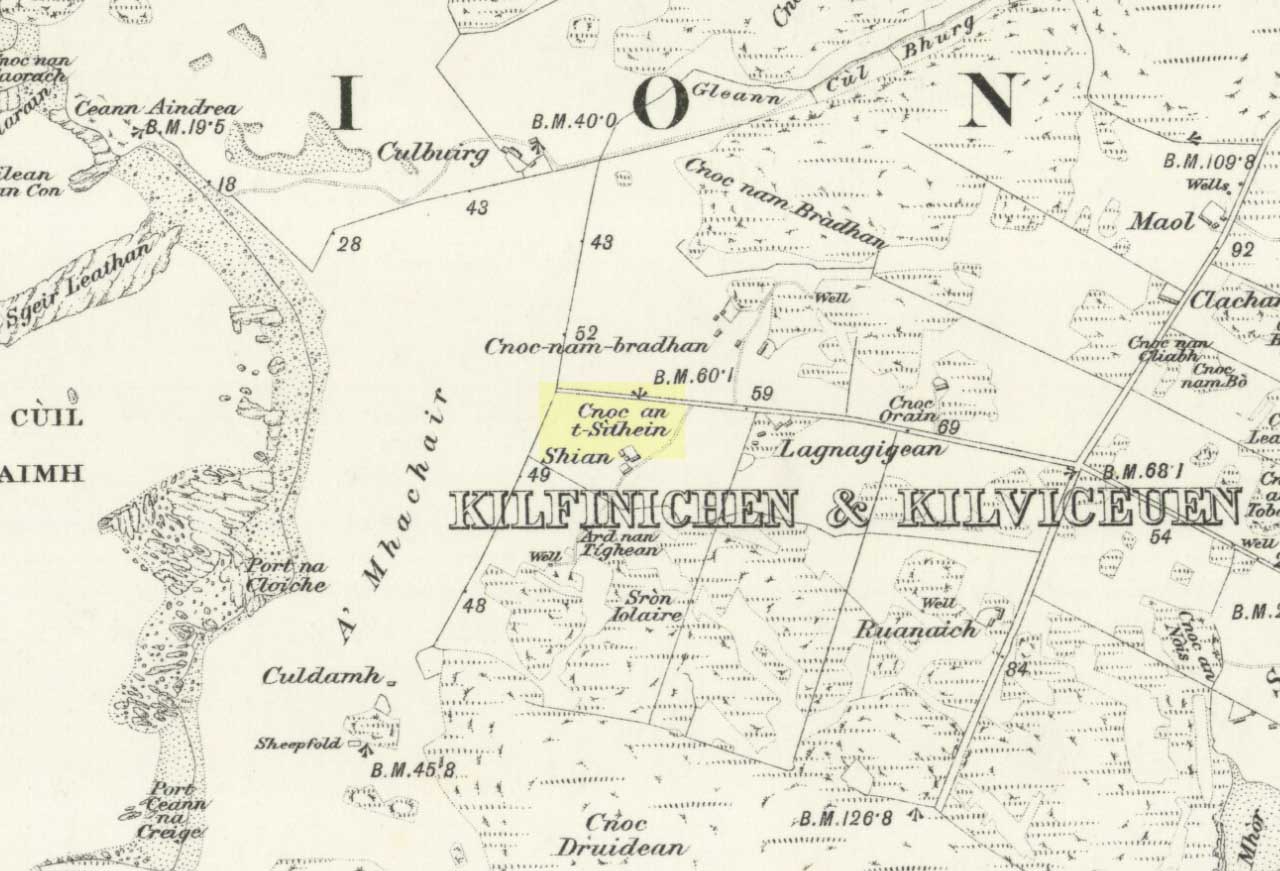
Site of the Sithean Mor on the 1881 OS-map
The day of the “feast of St. Michael” that Pennant mentioned was our indigenous heathen New Year, or Halloween, now usurped and misrepresented by countless plastic pagans and christians alike. It would appear from Pennant’s description that the circle in question was more likely a cairn circle. The fact that the heathen islanders celebrated annual rites here at Samhain, strongly implies there was once a hero-myth and a creation myth in evidence, but I am unaware of any remaining tales that may help confirm this. The coming of St. Columba may be responsible for this lack of oral tradition.
More than a century after Pennant’s visit here, the ring of stones had been destroyed. We know this from the description given by Archie MacMillan (1898) in his fine text on the antiquities of Iona, where he said,
“Angel Hill, called in the vernacular Sithean More. There was, not so very long ago, a circle of standing stones on the top of this hillock. They have been used for other purposes.”
Folklore
The most commonly recited tale of this grassy rise is that when St. Columba brought christianity to the island, he communed here with the angels. This is a simple displacement tale: of a new faith replacing an older one. The old name of the hill, Sithean Mor, tells that the littlepeople or fairy folk once held influence here.
References:
Cumming, C.F.G., In the Hebrides, Chatto & Windus: London 1883.
MacMillan, Archibald, Iona: Its History and Antiquities, Houlston & Sons: London 1898.
Pennant, Thomas, A Tour in Scotland, 1772 – Part 1, Benjamin White: London 1776.
At the pub by the bridge which crosses the Falls of Dochart (aptly called the ‘Falls of Dochart Inn’), walk downstream following the dirt-track which runs parallel with a section of the river for a good 5-600 yards. In the field that appears on your right, watch out for the rise of the stones as you approach the large gates which take you into the ground of Kinnell House. You can climb over the gate just into the field and go straight to the stones.
Archaeology & History
Found on the field called Kinnell Park in the grounds of Kinnell House, less than a mile out of Killin, this is a well-preserved site consisting of six stones. It appears to have been described first of all by Thomas Pennant in 1772, in the same breath as the megalithic remains at Lawers on the other side of Loch Tay. Pennant wrote:
“In going through Laurs observe a Druidical circle; less complete indeed than one, that should have been mentioned before, at Kinnel, a little southwest of Killin; which consists of six vast stones, placed equidistant from each other.”
Coles’ 1910 plan of KinnellThom’s geometric plan
It would seem that the site has changed little since Pennant’s visit. Sitting on a reasonably level grassy plain, the hills rise and surround the small ring of stones, with the lower horizons running along the south. Due west (equinox) we have the large pyramidal hill of Meall Clachach; whilst to the north are the legendary hills of Creag na Cailleach and Ben Lawers, each with their own rich mythic archaeological legacies. Legendary stones and wells are also close by, some with rites still enacted by old local people keeping truly ancient traditions alive.
The first detailed archaeological survey of the Kinnell site was done by Fred Coles and published in 1910. It has yet to be superseded. Mr Coles wrote:
“Taking the Stones in the usual order…I here give their dimensions and characteristics: Stone A, 6 feet 3 inches high, springs from an oblong base which girths 11 feet 4 inches, to a rough irregular top; Stone B leans forward towards the centre of the Circle, and measures along its sloping back 6 feet 9 inches, the present height from the ground to its upper edge being 4 feet. It is of smooth garnetiferous schist, and free from the deep fissures and rifts so common in these Stones. Stone C, a very rectangular but narrow block of schist, has a 15 Feet-girth at the base of 9 feet, but tapers up from both ends to a pyramidal summit, 5 feet 4 inches above ground. Its inner face is over 6 feet in breadth. Stone D, 4 feet 6 inches high, is a broad, flat-topped, very massive block, measuring 9 feet 5 inches round the base, but near the middle of its height 11 feet 2 inches. Stone E, the shortest of the group, is only 4 feet high, has a rough, uneven top, and a basal girth of 8 feet 11 inches. Stone F, the tallest, measures 6 feet 4 inches in height, but in girth only 7 feet 3 inches. It is very rough, vertically fissured in many places, and full of white quartz veins.
“Neat, well-defined, and comparatively small as this Circle is, it is to be noticed that the positions of the Stones do not conform to perfect regularity as points on the circumference. On working out the plan, the measurements prove that a diameter of 29 feet exactly bisects three of the erect Stones, B, C, and F, but leaves the other two untouched. The interspaces of the settings are not all quite equal, a space of 14 feet 8 inches dividing the centres respectively of F and A, A and B, F and E, and E and T); but between D and C it is 13 feet 8 inches, and between 0 and B I S feet 5 inches. Yet, the Stones stand proportionally near enough to each other to give one a satisfying impression that these six megaliths represent the group in its completeness, and that there were no smaller blocks between any two of them. The space enclosed by these stones is quite smooth and level, bearing no indication of having at any time been disturbed.”
Many years later, the late great Alexander Thom came here and, with his geometric perspective, gave a more precise ground-plan and lay-out. Thom (1980) defined the site as a “Type B flattened circle, or possible ellipse,” with a perimeter of 35 megalithic yards and diameter of 11.8 MY. Aubrey Burl’s commentary described Kinnell as:
“Six stones of schist stand evenly spaced on the circumference of an ellipse 32ft 7in x 27ft 5in (9.9 x 8.4m) in diameter. The stones are graded in height towards the SW where the two tallest are over 6ft (1.8m) high.”
One of the upright stones was said by Hugh MacMillan (1884) to have had cup-markings on it in the 19th century, when he told of the circle possessing “some seven or eight tall massive stones, with a few faint cup-marks on one of them.” But these appear to have faded, or were cut into the one of the missing stones.
Folklore
Close to the Kinnell circle could once be found a curious large boulder, covered in moss, but with a large cavity in which water gathered. Local lore ascribed the rock to actually be a well, as it was known as ‘The Well of the Whooping-Cough’, or Fuaran na Druidh Chasad, measuring some eight feet long and five feet high. Local people visited the site to be cured of the said disease, but Hugh MacMillan also suggested that the miraculous well-in-the-stone was connected with ancient rituals once enacted at the Kinnell circle, saying:
” it is a reasonable supposition that the Fountain of the Whooping-Cough may have had some connection in ancient times with this prehistoric structure in its immediate neighbourhood…”
He may have been right!
…to be continued…
References:
Burl, Aubrey, A Guide to the Stone Circles of Britain, Ireland and Brittany, New Haven & London 1995.
Pennant, Thomas, A Tour in Scotland, 1772 – Part 2, Benjamin White: London 1776.
Royal Commission on the Ancient & Historical Monuments of Scotland, Archaeological Sites and Monuments of Stirling District, Central Region, Society of Antiquaries of Scotland 1979.
Thom, A., Thom, A.S. & Burl, H.A.W., Megalithic Rings, BAR: Oxford 1980.
Wheater, Hilary, Killin to Glencoe, Appin Publications: Aberfeldy 1982.
On the A657 road, a half-mile past Greengates towards Calverley, just before the road starts going uphill, take the lower dirt-track of Eleanor Drive on your left into Calverley Woods (here known as West Woods). About 150 yards along the track, note the small footpath on the right which goes up diagonally further into the trees. Go along here until you reach the remains of a dried-up pond on your left. The carved stone is about 10 yards before the pond, just above the footpath.
Archaeology & History
Rubbing of the 2 cupmarks
Another stone only for the puritans amongst you! This (and the West Woods 2 carving) was one we found in 1985 when we were exploring the woods looking for the Calverley Woods cup-marked stone reported by Sid Jackson in the 1950s. The stone is a small roughly oblong, earthfast rock, about 2ft by 1ft across, and has two distinct but faded cup-marks on its slightly sloping face. That’s it!
Soon after first finding this, we made a couple or rubbings of the stone, one of which I reproduce here and which shows the two cup-marks. You’ll note the measurement and note of the cups being 2 megalithic inches (MI) in diameter. The MI was a statistical unit of measure suggested by the late great Alexander Thom, who found regular integers of 2.07cm in many of the cup-and-rings he examined, and so surmised it as a deliberate numeric system. At the time when we found this cup-marked stone, I was exploring Thom’s idea and was very much taken up with it. However, after a few years doings numerous rubbings of the many cup-and-ring stones in West Yorkshire, and exploring the simple size of the human hand and how we execute cup-markings on rocks, I found Thom’s idea didn’t seem to be realistic. (though I still love Thom’s works: the man was an outstanding researcher, far exceeding all the archaeologists of his period in terms of his exploratory methods)
References:
Bennett, Paul, “The Undiscovered Old Stones of Calverley Woods,” in Earth 2, 1986.
Although originally classed as a stone circle, this site should more accurately be described as a form of cairn circle, as burial remains were found in the middle. This is noted by both Aubrey Burl (2000) and John Barnatt (1989), who thought it to be a kerbed cairn. It’s only a small circle aswell, about 5 yards across and is found not far from other burial cairns in the neighbourhood.
First discovered around Easter in 1965 by the then owners of the farm, Mr & Mrs K. Jarman, parts of the circle were dug into by their children, who subsequently informed Sheffield City Museum of their finds. Subsequently, the circle was then described in a short article by J. Radley (1969) in ‘Notes on Archaeological Finds’ for the Yorkshire archaeology group. He wrote:
“The circle is 15ft in diameter and is made of ten stones which protrude a few inches above the turf cover. Inside the circle the ground is slightly concave. A two-feet wide trench was dug across the circle and a large stone was revealed at the centre. On the stone was a fragmented urn, remains of a cremation, and one fragment of flint. There are signs of burning on the stone, and also under the stone, but no other burial has been discovered. The whole burial was so shallow that it was in the root zone of the overlying grass. The survival of many pieces of bone in such a wet location suggests that the area must have been protected by a mound until quite recent times…
“The urn is too fragmentary to be restored. Of the hundreds of fragments, only a few retain both faces, and these are generally one centimetre thick. The urn appears to have been made of a fine clay with large grits and has a smooth brown surface marked in places with impressions of blades of grass. The urn may have been biconical in form with bands of horizontal grooves around the upper part, with vertical grooves below them.”
References:
Barnatt, John, The Stone Circles of Britain – volume 2, British Archaeological Reports: Oxford 1989.
Burl, Aubrey, The Stone Circles of Britain, Ireland and Brittany, Yale University Press 2000.
Radley, J., “A Stone Circle on Kirkmoor Beck Farm, Fylingdales,” in Yorkshire Archaeological Journal, part 167, volume 42, 1969.
Standing Stone (destroyed?): OS Grid Reference – SE 282 402
Archaeology & History
Idol Rock, Adel (Simpson 1879)
Difficult to know what to think about this one. It seems to have been described just once in the latter half of the 19th century by that real Bible-thumping nutcase, Henry Simpson (1879), who gave us the only known picture of the place. Simpson said that it was, “the remains of supposed Idol Rock on the moor near Adel reformatory, under the Alwoodley Crags. About six foot high.” It is believed to have been destroyed, but having not checked the region thoroughly, it could still be there somewhere (the grid reference cited here is an approximation). Does anyone know owt else about it?
References:
Simpson, Henry T., Archaeologia Adelensis, W.H. Allen: London 1879.
Bittova journey this — but well worth it! From Broughton-in-Furness take the A595 road west, past Duddon Bridge for about another 1½ miles, turning right up the small single-track country lane beloved of city-mind drivers, up the fertile scruffy road, past Broadgate and stopping just before Cragg Hall Farm. There’s a dirt-track running up the back of Cragg Hall. Go up here and keep walking for a mile or so until, as you approach Swinside Farm and the fields open up in front of you, the stones begin to appear.
Archaeology & History
Swinside, looking east
The Swinside stone circle is Aubrey Burl’s favourite. And for good reason! Like other impressive megalithic rings of the region, the stones are large, well set, and the landscape holds the stones finely in the hills. Without the landscape here, Swinside (like Castlerigg and elsewhere) would not have such grandeur. When you sit in the ring, or walk round it, Knott Hill to the south was of obvious mythic relevance to the people who built this stone circle four or five thousand years ago. But this can be said of many of the surrounding crags. A few miles southwest we see the top of the haunted Black Combe rising into clouds, still speaking to some with spirits from animistic realms, long known to our ancestors. Following the skyline west and past the small falls of Whicham stream, whose name speaks of long past trees, we reach the near-west skyline with the cairn-looking pap of the Raven Crag, symptomatic of magickal rites calling to and beyond the circle. To the north is the symbolic ridge of Lath Rigg. Along the craggy eastern ridges from here you get the impression that you’re more in Argyll than Cumbria; and the break in the hills to the southeast reaches to the distant pinnacle of Kirkby Moor, where the midwinter sunrise emerged to tell of solar calendrical motions and the coming of the dark season to our megalithic tribes. But enough of the landscape!
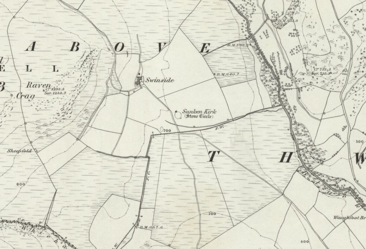
Swinside on 1867 OS-map
Although the name Swinside can be traced back to the 13th century, the local folk-name of the circle—Sunken Kirk—was mentioned for the first time as “the Chapell Suke” in Parish Registers of 1624. No earlier literary source has yet been identified, probably because of the isolation of the site and the lack of people writing about the area. Swinside stone circle is, just about, a perfect circle, give or take a foot here and there, holding the circular dome of the heavens within its domain. Yet despite its almost regal appearance, early references to the site seem scant. It seems to have been first described in William Hutchinson’s huge History of Cumberland (1794), where he told:
“In the neighbourhood of Millum, at a place called Swinside, in the estate of William Lewthwaite Esq., of Whitehaven, is a small but beautiful druidical monument; it is circular, about twenty eight yards in diameter; the stones of which it is composed are from six to eight feet high, all standing and complete. A little to the south, is another of larger dimensions, but not in so perfect a state: the neighbouring people call those places by the emphatical names of Sunken Kirks.”
A few years later, William Camden’s legendary text Britannia was edited and reprinted again, this time by Richard Gough (1806), who told:
“At Swineshead, a very high hill…is a druidical temple, which the country folk call Sunken Kirk, i.e., a church sunk into the Earth. It is nearly a circle of very large stones, pretty entire. No situation could be more agreeable to the Druids than this; mountains almost encircle it, not a tree is to be seen in the neighbourhood, nor a house, except a shepherd’s cot at the foot of a mountain surrounded by a few barren pastures. At the entrance are four large stones, two placed on each side at the distance of six feet. The largest on the left hand side is five feet six inches in height, and ten feet in circumference. Through this you enter into a circular area, 29 yards by 30. This entrance is nearly southeast. On the north or right-hand side is a huge stone of conical form, in height nearly nine feet. Opposite the entrance is another large stone which has once been erect, but is now fallen within the area: its length is eight feet. The left hand or southwest is one, in height seven feet, in circumference 11 feet nine inches. The altar probably stood in the middle, as there are some stones still to be seen, though sunk deep in the earth. The circle is nearly complete, except on the western side some stones are wanting. The largest stones are about thirty one or two in number. The outwards part of the circle upon the sloping ground is surrounded with a buttress or rude pavement of smaller stones raised about half a yard from the surface of the Earth… This monument of antiquity, when viewed within the circle, strikes you with astonishment, how the massy stones could be placed in such regular order either by human strength or mechanical power.”
Tall, northernmost stone to centreNortheast section of the ring
It seems he was impressed! Yet despite this, in the 19th century not many folk strayed this far into the western edges of Lakeland to look upon Swinside. There were occasional descriptions from travellers and antiquarians such as J.T. Blight (1843) and Edwin Waugh (1861), each speaking of the site’s visual magnitude, but it wasn’t until archaeologist C.W. Dymond came here, first in 1872 and then again in 1877, that a fuller account of the site came into being. In his essay on a “Group of Cumberland Megaliths,” he said how the stones were still in excellent condition and that,
“few of the stones seem to have been removed — probably because plenty of material for walling and road-making could be collected from the neighbouring hillside.” (Dymond 1881)
When Mr Dymond first came here he told of the remains of a rowan tree which had split one of the stones, but this has long gone. More than twenty years after the archaeologist’s first visit, he returned with R.G. Collingwood to make a more detailed evaluation of the ring. He measured and planned Swinside like it had never been done before and his ground-plan (below) is still very accurate indeed. Aubrey Burl (1999) takes up the story:
“The ring was partly excavated by Dymond, Collingwood and three men from midday Tuesday, 26 March 1901, until the close of the following evening. They dug two long, intersecting 46cm-wide trenches, NW-SE, NE-SW, across the ring with a curious zigzagging pattern of others between southeast and southwest: an investigation of some 51m² of the central area. Within the circle the trenches represented less than a thirteenth of the 642m² of the interior.
“Below the grass and turf was a thin layer of soil under which yellowish marl or ‘pinnel’ varied from 15cm to 75cm in depth, being deepest at the entrance which had been dug into earlier around 1850. Wherever it was uncovered the gravelly marl was wavily uneven, presumably the result of ploughing. The bases of the circle-stones rested on the pinnel, held firmly in their holes by small cobbles with others heavily packed around the sides. The only finds were a nut-sized lump of charcoal just northeast of the centre with others near the entrance; a minute splinter of decayed bone near the first bit of charcoal and two pieces of red stone. There were also some contemporary glass sherds and a Lancaster halfpenny dated between 1789 and 1794 lying in the uppermost turf layer.”
Dymond’s 1881 plan of Swinside
Since these early archaeological digs, Swinside has given up little else. Much like other stone circles in the British Isles, few real clues as to exactly what went on here have been forthcoming. But in the 1960s, investigations into megalithic sites made a bit of a quantum leap and some old ideas about astronomical ingredients were resurrected.
Alexander Thom’s plan of Swinside
Swinside was one of the places explored by engineer and megalith enthusiast, Alexander Thom. Thom was one of the prime figures instrumental in the resurgence of interest in megalithic sites — and his finds of megalithic astronomy and prehistoric mathematics had a lot to do with it. Although we know today that some of Thom’s work isn’t correct, his explorations and research stand him far ahead of most archaeologists who pretended to represent this area of research. He left us with the most detailed ground-plans of megalithic sites to date and, of course, showed some fascinating alignments.
Thom listed Swinside as site “L1/3” and made the most detailed and accurate ground-plan of this and 18 other megalithic rings in Cumbria. He found it to be 94 feet in diameter, with an internal area measuring 6940 square feet. The one major alignment Thom found at Swinside was of the winter solstice sunrise, lining up just on the edge of the ‘entrance’ to the circle’s southeastern side.
Folklore
Like a number of other stone circles, folklore told that you couldn’t count the stones. Janet and Colin Bord (1997) also told that people once tried to build a church here in early christian days, but once the builders went home in the evening, the Devil pulled down what they’d built during the day. A motif found at Ilkley’s Hanging Stones cup-and-ring carvings and many other prehistoric sacred sites in the country.
…to be continued…
References:
Armstrong, A.M. et al., The Place-Names of Cumberland – volume 2, Cambridge University Press 1950.
Bord, Janet & Colin, Prehistoric Britain from the Air, Weidenfeld & Nicolson: London 1999.
Burl, Aubrey, “‘Without Sharp North…’ – Alexander Thom and the Great Stone Circle of Cumbria”, in Ruggles, Clive, Records in Stone, Cambridge University Press, 1988.
Burl, Aubrey, A Guide to the Stone Circles of Britain, Ireland and Brittany, New Haven & London 1995.
Burl, Aubrey, Great Stone Circles, Yale University Press: New York & London 1999.
Burl, Aubrey, The Stone Circles of Britain, Ireland and Brittany, Yale University Press 2000.
Dymond, C.W., “A Group of Cumberland Megaliths,” in Transactions of the Cumberland and Westmorland Antiquarian and Archaeological Society, volume 5, 1881.
Dymond, C.W., “An exploration at the Megalithic Circle called Sunken Kirk at Swinside, in the Parish of Millom, Cumberland,” in Transactions of the Cumberland and Westmorland Antiquarian and Archaeological Society, New Series volume 2, 1902.
Gough, Richard (ed.), Camden’s Britannia, J. Nichols and Son: London 1806.
Hutchinson, William, The History of the County of Cumberland – volume 1, F. Jollie: Carlisle 1794.
Seton, Ray, The Reason for the Stone Circles in Cumbria, R. Seton: Morecambe 1995.
Thom, Alexander, Megalithic Sites in Britain, Oxford University Press 1967.
Thom, A., Thom, A.S. & Burl, H.A.W., Megalithic Rings, BAR: Oxford 1980.
Waterhouse, John, The Stone Circles of Cumbria, Phillimore: Chichester 1985.
Waugh, Edwin, Seaside Lakes and Mountains of Cumberland, Alexander Ireland: Manchester 1861.
ACKNOWLEDGEMENTS:
Huge thanks to Brian Else for his photos. And to Paul and Tricia for taking us here, in awesome downpour weather!
From Feizor village, take the dirt-track south that cuts up between the two cottages and walk onto the level. From here, the walling bends round and a small cut runs up the slope on your left. Go up here and onto the top, bearing left again when you reach the footpath near the top of the slope. Walk along here until the hills open up before you and less than 100 yards along, just on the right-hand side of the path, you’ll notice the overgrown outline of a ring just by the side. Don’t miss it (like I did!).
Archaeology & History
Danny, Paul and I visited here a few weeks back on a fine sunny day and, my attention caught by some nearby rocks that got mi nose twitching, I just about walked past the place until Danny called me back and said, “Oy – ‘ave y’ not seen this?” Right under my nose no less!
Feizor Thwaite circle, looking northwest
The site’s a little known circular monument east of Feizor village, less than a mile northwest of the cairnfield above Stackhouse (where lives the Apronful of Stones and other prehistoric friends). Marked on modern OS-maps as an ‘enclosure,’ the site here is in fact an overgrown cairn circle, typical in size and form of the ones found at nearby Borrins Top, Burley Moor, Askwith Moor and elsewhere in the Pennines. Measuring (from outer edge to outer edge) 66 feet 6 inches east-west and 59 feet north-south, the remains here consist of a raised embankment of stones, encircling an inner flatter region consisting of many smaller stones beneath the overgrowth of grasses and vegetation. Locals told me that the some of the cairns up here were explored early in the 20th century by a local man called Tot Lord, but I’m unsure whether he looked at this one.
There are a couple of other smaller circular remains on the same grassland plain, clearly visible from aerial imagery, along with other crop-marks of human activity on this part of the Feizor Thwaite landscape. More antiquarian analysis could do with focussing here to see what can be found!
Standing Stone (destroyed): OS Grid Reference – SD 78570 67177
Archaeology & History
Feizor on 1851 map
There have been no previous archaeological reference to this site (until now), which was included in early place-names records (Smith 1961) and was also highlighted on the first Ordnance Survey map of the region around 1851. Probably as a result of the archaeological lacking, the upright stone has finally succumbed to the destructive actions of modern man. When we asked the farmer if he knew owt about any standing stone here, he said he knew “nowt abaat that.”
Feizor stone stumpand from another angle
All that can be seen today is the very small stump of stone, just visible above ground level, in the middle of the field. It’s not easy to spot either, as the grasses grow over what’s left. But we found the slim remnant of the stump embedded in exactly the spot marked on old and modern maps, measuring 24 inches in length and just 4 inches across at the widest, with what seemed like worn rounded edges at either end. We were unable to ascertain the depth of the remaining stone in the ground. The stone looks simply as if it’s been snapped at the base. We have no idea how tall this standing stone was.
If any local people know anything more about this stone, or have any old photos, we’d love to hear from you — and would obviously give due credit for any help on this matter.
References:
Smith, A.H., The Place-Names of the West Riding of Yorkshire – volume 6, Cambridge University Press 1961.
Not included in Burl’s (2000) magnum opus, it looks as if this place has long since gone – but perhaps a local or a wanderer might find remnants of it still there somewhere. The only thing I’ve so far found about it is in Martin Martin’s journey here in 1695, where he described this “stone circle in the sea” thus:
“On the east-side of the village Rowdil, there is a circle of stone, within 8 yards of the shore: it is about 3 fathoms under water, and about 2 stories high: it is in form broader above than below, like to the lower story of a kiln: I saw it perfectly on one side, but the season being then windy, hindered me from a full view of it. The natives say that there is such another circle of less compass in the Pool Borodil, on the other side of the bay.”
Local people say that the structure is a natural one, with others of a similar nature found close by. Does anyone know more about this – and perhaps about the other apparent circle at Borasdal, less than a mile to the west?
References:
Martin, Martin, A Description of the Western Islands of Scotland in 1695, Eneas Mackay: Stirling 1934.


")
")

")
")


")
")