Borgie Bridge Stone Row, Tongue, Sutherland

Stone Row: OS Grid Reference – NC 6613 5874

Also Known as:

  1. Allt Loch Tuirslighe
  2. Canmore ID 5745

Getting Here

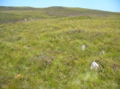
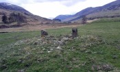
The site of the stone rows

The site of the stone rows

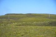
Take the A836 road between Bettyhill and Tongue and, roughly halfway between the two villages, a few hundred yards west of the turning to Borgie, park up at the roadside. Cross the road and through the gate, follow the waters of Allt Loch Tuirslighe for 100 yards and then walk uphill onto the moors. You’re damn close!

Archaeology & History

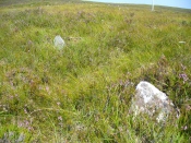
This megalithic stone row was uncovered in the late 1970s – which is no surprise to be honest.  It is a very low parallel row of small upright stones, which Freer & Myatt (1982) initially found to consist of two rows of standing stones, twelve in all. When we visited the site a few days ago, I could find only ten of them that could appreciably be termed authentic – and that was stretching it a bit!

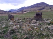
Several of the low stones

Several of the low stones

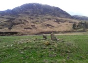
Close-up of the small stones

Close-up of the small stones

Of the two stone rows presently visible, the easterly one is easier to see and consists of seven small stones, running almost in a dead straight line NNE.  A few yards west we find the second stone row, in which I could only discern three tangible contenders, also running NNE, but slightly fanning outwards and away further north. When standing in the middle of the two rows, they align to a small natural rocky outcrop on the near-horizon 100 yards away, upon which Paul Hornby recently discovered 3 or 4 faint cup-markings. If we turn 180 degrees and look in the opposite direction, the alignment of stones points to the highest peak in the far distance.

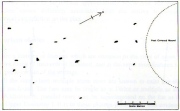
Myatt's 1988 survey

Myatt’s 1988 survey

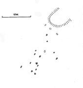
Gourlay's 1996 survey

Gourlay’s 1996 survey

All of the stones are small and difficult to see upon initial exploration. The highest of them stands no more than 1½ feet tall, with their average less than 1 foot. One of the stones in the eastern row is covered completely by vegetation.  However, in earlier assessments of this site, quite a few other stones were visible.  Its brief history and appearance was described in Leslie Myatt’s (1988) survey of such monuments in this remote region, where he told:

“This very ruinous setting of stone rows was fist recorded by the Archaeology Division of the Ordnance Survey… Peat cutting has taken place in the area and undoubtedly a number of stones have been removed from the site.

“(The illustration) shows the result of a survey carried out by the author showing a total of only 16 stones not more than 20cm above the surface.  Because of the small number of stones remaining, it has not been possible to superimpose a geometric construction on the site.  The ground slopes upwards to the north-northeast, at which end of the setting is a low peat-covered mound about 10m in diameter.  It has no distinctive features, although it does not appear to be natural…”

The site is described in Alexander Thom’s (1990) major survey, but sadly he didn’t turn his direct attention here, so we still have no accurate geometric or astronomical assessment.  A few years later Aubrey Burl (1993) gave us details of the larger initial size of the complex and told us that at

“Borgie, near Torrisdale Bay on the north coast of Sutherland, perhaps an early site, has three or four lines with the suspicion of a fifth.  The rows narrow from their base 20ft (6.1m) across to 18ft 8in (5.7m) over a distance of 59ft (18m), a contraction as they worm uphill towards a peat-covered mound of hardly a quarter of an inch in a foot (0.6: 31cm).”

The small peat-covered mound which the stone rows lead up to was suggested by Robert Gourlay (1996) as “perhaps a small cairn.”

References:

  1. Burl, Aubrey, From Carnac to Callanish, Yale University Press 1993.
  2. Freer, R. & Myatt, L.J., “The Multiple Stone Rows of Caithness and Sutherland,” in Caithness Field Club Bulletin, 3:3, April 1982.
  3. Gourley, Robert, Sutherland: An Archaeological Guide, Birlinn: Edinburgh 1996.
  4. Myatt, Leslie, “The Stone Rows of Northern Scotland,” in Ruggles 1988.
  5. Ruggles, Clive, Records in Stone: Papers in Memory of Alexander Thom, Cambridge University Press 1988.
  6. Thom, A., Thom, A.S. & Burl, Aubrey, Stone Rows and Standing Stones – 2 volumes, BAR: Oxford 1990.

© Paul BennettThe Northern Antiquarian

Glenshervie Burn, Glen Almond, Perthshire

Ring Cairn:  OS Grid Reference – NN 82614 32996

Also Known as:

  1. Canmore ID 25565
  2. River Almond

Getting Here

The ruins of Glenshervie Circle

The ruins of Glenshervie Circle

Take the dirt-track, off-road, up to the start of Glen Almond, for more than 4 miles — past the curious Conichan Ring, and past the standing stone of Clach an Tiompan, until you see the large modern walled circle in the field on your left.  Go into that field and you’ll notice a ruined pile and small standing stones 56 yards (51m) WSW.  Y’ can’t really miss it!

Archaeology & History

Sitting upon a flat grassland plateau close to the confluence of the Glenshervie Burn with the River Almond, the visitor here will notice an overgrown ovoid mass of old worn stones in the form of a prehistoric cairn, with two upright standing stones on the western edges of the pile.  This is the remains of what the megalithic magus Aubrey Burl (1988) called the Glenshervie “four poster” stone circle.

Glenshervie stones, looking N

Glenshervie stones, looking N

Glenshervie stones, looking W

Glenshervie stones, looking W

Structurally similar to the neighbouring four-poster of Clach an Tiompan 470 yards (427m) to the ESE, and less damaged than the remaining megaliths of Auchnafree 568 yards (520m) to the northwest, this megalithic ruin was first mentioned in passing by Audrey Henshall (1956) in her survey of the giant Clach an Tiompan tomb and its adjacent ring.  She told that,

“In meadowland beside the Almond, a small circle of standing stones, hitherto unrecorded, protrude through the water-worn material of a low cairn.  This is a similar type of monument to the ruined site at Clach na Tiompan.”

Close-up of cairn & stones

Close-up of cairn & stones

Glenshervie ruins, looking S

Glenshervie ruins, looking S

Indeed it is!  Sadly however, it remains unexcavated — so we know not what its precise nature and function may have been.  When Burl included the site in his 1988 survey, he could add nothing more than I can; but curiously described the two standing stones here as being only “about 1 ft (30cm) high.”  They’re between two and three feet tall respectively, and the remaining cairn is between 5 and 6 yards in diameter, with the central rubble rising between 1 and 2 feet above the natural ground level.

The landscape at the point where this circle was built enables you to look up and down the glens of Almond and Shervie in three different directions.  Whether or not this was deliberate, we cannot know for sure.  But the setting on the whole, in the middle of where the glen widens out and hold this and the nearby monuments, is a beautiful setting indeed…

References:

  1. Burl, Aubrey, Four Posters: Bronze Age Stone Circles of Western Europe, BAR 195: Oxford 1988.
  2. Henshall, Audrey & Stewart, M.E.C., “Excavations at Clach na Tiompan, Wester Glen Almond, Perthshire,” in Proceedings of the Society of Antiquaries, Scotland, volume 88, 1955.

© Paul BennettThe Northern Antiquarian


Gough’s Barrow, Long Compton, Warwickshire

Archaeology & History

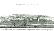
Only known drawing of Gough's Barrow

Only known drawing of Gough’s Barrow

In days of olde there were heathen sites around the edges of the beautiful Rollright Stones complex that have sadly fallen prey to the intensive agriculture of more modern ‘civilized’ times.  It’s become the way of things….. One site of importance in this geomythic  pantheon was the ‘Gough’s Barrow’—so named after a drawing was done of the site by Richard Gough, editor of the 1789 edition of Camden’s Britannia.  As far as I’m aware, it is the only one ever done of this monument.  The Oxford archaeologist George Lambrick (1988) saw “every reason to accept the position and details of the barrow”, upon which stood at least two large stones—one of which gained the description of a ‘druidical pillar.’

Stukeley's 1743 drawing

Stukeley’s 1743 drawing

The same barrow may have been recorded in one of drawings of the great William Stukeley, who visited the Rollright Stones in 1710 and then again in 1723.  On the left-side of the adjacent drawing you can see a denuded mound close to the edge of the picture, similar in shape and form to that drawn by Richard Gough.  It is probably the same tumulus or barrow.  Trial excavations at the site in 1983 looked for any remains of the old tomb, but nothing significant was uncovered.  Lambrick estimated that the site probably measured “about 18m wide and 20m long east-west,” and “was a megalithic barrow and was therefore probably Neolithic in origin.” 

References:

  1. Bennett, Paul & Chanter, James, The Complete Rollright Stones, forthcoming
  2. Bennett, Paul & Wilson, Tom, The Old Stones of Rollright and District, Cockley Press: Chipping Norton 1999.
  3. Burl, Aubrey, Great Stone Circles, Yale University Press 1999.
  4. Lambrick, George, The Rollright Stones, English Heritage 1988.
  5. Peters, Frances, “An Antiquarian Visit to the Rollright Stones,” in Wiltshire Archaeological & Natural History Magazine, volume 94, 2001.
  6. Stukeley, Willliam, Abury – A Temple to the British Druids, London 1743.

© Paul Bennett, The Northern Antiquarian

Tillicoultry House Carving, Tillicoultry, Clackmannanshire

Cup-and-Ring Stone (lost):  OS Grid Reference – NS 9240 9752

Also Known as:

  1. Canmore ID 48255

Archaeology & History

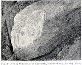
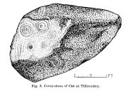
Multiple-ringed carving

A recent visit to try find this intricate carving—the only one of its kind in Clackmannanshire—proved unsuccessful, and so I add it here in the hope that someone might know where it is and bring it back to light.  It looked like quite an impressive petroglyph.  If the stone isn’t hiding in undergrowth at the edge of someone’s garden, it may well have been destroyed—which would be appalling.  As a unique design, this important carving should have been preserved.  Even when the Victorian explorers found it, the covering stone circle had been greatly damaged and many stones in the ring had been removed.  This carved stone remained intact however.  When Mr R. Robertson (1895) and his friend visited the site, it was covered in sand and dirt and had fallen to the side of an internal cist:

“On clearing this away a remarkable feature was brought to light.  The block was found to be elaborately ornamented on its sides and upper surface, with rings, spirals and lines.  The labour of cutting these in the hard granite with primitive tools of the period must have been very great. Several successful photos of the stone and its carvings were taken by Provost Westwood, Dollar…. This stone has now been removed to the vicinity of Tillicoultry for safety.”

In the same article, George Black told slightly more of the design:

“The covering stone of the cist…bears on the face a series of concentric circles, and spirals springing from one of the groups of circles,  Four grooves also unite the same set of circles with the left-hand edge of the stone.  On the edge shown in the photograph there is another group, consisting of two concentric circles.  The unevenness of the surface of the stone appears to have been of no moment to the sculptor of the circles, as the incisions follow the surface into its sinuosities and depressions.”

Not long after Robertson & Black’s visit, the great megalithomaniac Fred Coles (1899) came here—and he found that the “spirals” that Mr Black described were nothing of the sort.

“The huge irregularly-shaped diorite boulder which covered the cist has several cup-and-ring marks on one face and one side…. These marks are now, so I was informed when inspecting them, very much less distinct than they were when the photograph was taken (above) in 1894.  It would be difficult now to describe the incised markings with accuracy; it is difficult even to see them when wet.  But…I must take exception to the term ‘spirals’ as applied to any of these ‘rings.’  There are three groups of rings so placed as to make the outermost ring in each group touch that of the others (not an uncommon form), but there is no one true volute.

“…What is more noteworthy is the group of four long parallel, nearly perpendicular grooves issuing (probably) from the outermost ring of the group of five rings, and ending at the edge of the boulder.”

Alison Young’s 1937 sketch

Cole also noted that the carvings were to be found on the upper surface of the stone.  It would seem very probable that the excessive erosion which Cole described was due to the fact that the stone was, many centuries earlier, exposed to the elements within the stone circle and not buried as it later came to be.  It makes sense.

The excessive erosion was spoken of by the Royal Commission (1933) lads, aswell as the last person to describe the site, Ronald W.B. Morris (1981), who said that during his visits here between 1966-75,

“the author has only found traces of possible cups visible on the rough surface, which has flaked badly.”

Morris (1981) said that the stone measured “1½m by 1¾m by ½m (5½ft x 4½ft x 2ft)”—and was last known to be some 10 yards NW of the Tillicoultry House cottage, but we could locate no trace of the stone or its carving.  If anyone is aware of the whereabouts or fate of this important neolithic carving, please let us know.

References:

  1. Coles, Fred R., (1899b) ‘Notices of the discovery of a cist and urns at Juniper Green, and of a cist at the Cunninghar, Tillicoultry, and of some undescribed cup- marked stones’in Proceedings of the Society Antiquaries, Scotland, volume 33, 1899.
  2. MacWhite, Eoin, “A New View on Irish Bronze Age Rock-Scribings,” in Journal Royal Society Antiquaries, Ireland, 76:2, 1946.
  3. Morris, Ronald W.B., ‘The cup-and-ring marks and similar sculptures of Scotland: a survey of the southern Counties, part II’in Proceedings of the Society Antiquaries, Scotland, volume 100, 1969.
  4. Morris, Ronald W.B., “The Cup-and-Ring and Similar Early Sculptures of Scotland; Part 2 – The Rest of Scotland except Kintyre,” in Transactions of the Ancient Monuments Society, volume 16, 1969.
  5. Morris, Ronald W.B., The Prehistoric Rock Art of Southern Scotland, BAR: Oxford 1981.
  6. Robertson, R., Black, G.F. & Struthers, J., ‘Notice of the discovery of a stone cist and urns at the Cuninghar, Tillicoultryin Proceedings of the Society Antiquaries, Scotland, volume 29, 1895.
  7. Royal Commission on the Ancient & Historical Monuments of Scotland, Fife, Kinross and Clackmannan, HMSO: Edinburgh 1933.
  8. Young, Alison, “Cup-and-Ring Markings on Craig Ruenshin, with some Comparative Notes,” in Proceedings of the Society Antiquaries, Scotland, volume 72, 1937.

© Paul BennettThe Northern Antiquarian

Stone of Mannan, Clackmannan, Clackmannanshire

Legendary Stone:  OD Grid Reference – NS 91114 91891

Also Known as:

  1. Canmore ID 48321
  2. Clackmannan Stone
  3. King Robert’s Stone

Getting Here

The Stone of Mannan

The Stone of Mannan

Take the A907 road between Alloa and Kincardine, and up the B910 into Clackmannan.  To get into the village, depending on which route you’re coming in, go up the Kirk Wynd or the Cattle Market—both of which lead you to the Main Street where, beneath the old clock tower, you’ll see the Market Cross and its companion erection just to the side. You can’t really miss it!

Archaeology & History

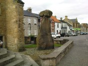
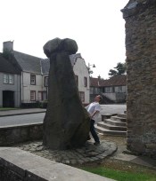
The phallic upright!

The phallic upright!

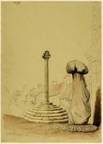
The history of this curious-looking giant phallic stone, sat quietly on the Main Street of sleepy Clackmannan village, isn’t as heathen as you’d expect when first seeing the huge upright—but there are mysteries and myths gathered about it.  The county of Clackmannan itself takes its name from this stone—but not the entire stone that we see today; merely the rounded, smaller element on top.  For it’s this that’s the real Mannan Stone. The rest of it, the tall upright pillar, was only attached to the smaller rounded stone—the Stone of Mannan— in the first-half of the 19th century.

First mentioned as a place-name in 12th century writings, the story of the stone was best told by Peter Miller (1889), who wrote:

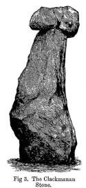
“The old ‘clack’ or stone that forms the prefix to the name-word Clackmananmust be of considerable antiquity.  Its form and appearance have nothing to excite remark. The two larger portions of the stone are battened together with iron, and the portion forming the cleft appears to be detached from the larger one.  It is only the legend or tradition respecting its history and its association with the name-word Clackmanan that makes it interesting to the antiquary. Its dimensions are as follows: —It is over 3 feet in length, 2 in breadth, and about the same in thickness.  Its form is oval, and it has a deep cleft on its upper side.  The stone has nothing peculiar about it to indicate what it may have been originally, or the uses it was made to serve in early times.  There is no appearance of its ever having had an inscription or any ornamentation upon it.  It is simply a boulder-stone stone of whinstone, such as are found in abundance at the Abbey Craig near Cambuskenneth.  It was placed on the tall boulder slab on which it now stands, brought from the Abbey Craig in the year 1833 by the late Robert Bruce of Kennet, and the late Professor Fleming, who was then minister of the parish.  Previous to that time it lay on the ground alongside of the old jail and court-house of Clackmannan, close by the old cross of the town…”

Clackmannan Stone (after Miller)

Clackmannan Stone (after Miller)

The old stone & its upright

The old stone & its upright

Mr Miller then went on at some length to show the derivation of ‘Clackmannan’ to be from the old Irish, meaning “the stone of the monks.”  It seems a plausible theory too.  Despite this, Watson (1926) deemed it to be the ‘Stone of Manau’, being deemed vaguely as the people of the land north of the Forth.  The great Celtic scholar John Rhys (1888) declared Clackmannan to derive from the Irish deity or hero-figure, Manannan, as have other academic authorities since then.  But it’s all just a bit vague if we’re wanting ‘certainty’…

When T.C. Crouther (1936) wrote about this, he said how the Stone of Mannan had originally come from a position only a few hundred yards south of its present spot, at a place known as Lookabootye Brae  (NS 912 911), just above where the land begins to drop down closer to sea level.  This doesn’t seems too improbable.  Close to this spot could once be seen the sacred site of the Lady Well.

At the turn of the 21st century the stone was caged by the local council as it was beginning to crumble and was in danger of collapse; and so, the local council repaired the great upright and its sacred top-stone—albeit at the staggering cost of £160,000!!!  As the local people and other masons know to this day, the job could have been done for a fraction of that cost with equal efficiency.

Folklore

Said by T.C. Crouther (1936), the local council, and others to have got its name from the sea god Mannan, other legends have grown around this fascinating old rock.  When Edwin Adams (1863) wrote about it, these were the tales that local people gave him:

“Its legendary history is curious. When King Robert Bruce was residing in Clackmannan tower, and before there was a town attached to that regal mansion, he happened, in passing one day near this way on a journey, to stop awhile at the stone and, on going away, left his glove upon it.  Not discovering his loss till he had proceeded about half-a-mile towards the south, he desired his servant to go back to the clack (for King Robert seems to have usually spoken his native Carrick Gaelic), and bring his mannan, or glove. The servant said, ‘If ye’ll just look about ye here, I’ll be back wi’t directly,’ and accordingly soon returned with the missing article.

£From this trivial circumstance arose the name of the town which was subsequently reared about the stone, as also that of a farm at which the King stopped, about half-a-mile from the south, on the way to Kincardine, which took its name from what the servant said, namely, ‘Look about ye,’ and is so called to this day.”

But as the various dates in this tale simply don’t add up, it seems that the writer had been easily fooled.

References:

  1. Adams, Edwin, Geography Classified, Chapman Hall: London 1863.
  2. Drummond, James, Scottish Market-Crosses, Neill & Co.: Edinburgh 1861.
  3. Drummond, James,”Notice of Some Stone Crosses, with Especial Reference to the Market Crosses of Scotland,” in Proceedings Society of Antiquaries, Scotland, volume 4, 1862.
  4. Gordon, T Crouther, The History of Clackmannan, Civic Press: Glasgow 1936.
  5. Miller, Peter, “Notices of the Standing Stones of Alloa and Clackmannan,” in Proceedings of the Society of Antiquaries, Scotland, volume 23, 1889.
  6. Rhys, John, Lectures on the Origin and Growth of Religion as Illustrated by Celtic Heathendom, Williams & Norgate London 1888.
  7. Royal Commission on the Ancient & Historical Monuments, Scotland, Inventory of Monuments and Constructions in the Counties of Fife, Kinross and Clackmannan, HMSO: Edinburgh 1933.
  8. Royal Commission on the Ancient & Historical Monuments, Scotland, The Archaeological Sites and Monuments of Clackmannan District and Falkirk District, Society of Antiquaries of Scotland 1978.
  9. Simpkins, John Ewart, County Folklore – volume VII: Examples of Printed Folk-Lore Concerning Fife, with some Notes on Clackmannan and Kinross-Shires, Folk-Lore Society: London 1914.
  10. Small, John W., Scottish Market Crosses, Eneas Mackay: Stirling 1900.
  11. Watson, W.J., The History of the Celtic Place-names of Scotland, Edinburgh 1926.

Links:

  1. Nataraja’s Foot – Skullduggery

Acknowledgements:  Big thanks to author Marion Grace Woolley for use of her photo in this site profile. 🙂

© Paul BennettThe Northern Antiquarian

Clach na h-ealea, Clachan, Lismore, Argyll

Legendary Stone:  OS Grid Reference – NM 861 435

Also Known as:

  1. Clach na h-eala
  2. Stone of the Swan
  3. Swan Stone

Archaeology & History

Although the lads at the Scottish Royal Commission (1974) initially described this site as a ‘Standing Stone’, it is in fact,

“an erratic boulder of granite roughly shaped in the form of a cross… It measures 0.8m in height, 0.6m in width at base, and 0.4m in width at the top…(and) the stone is supposed to have marked a boundary.”

The site was evidently of some mythic importance, as the great Cathedral of St. Moluag was built next to the stone — unless the giant cairn of Cnoc Aingil, 500 yards away, was to blame. A holy well of this saint’s name (an obvious heathen site beforehand) is also nearby.

Folklore

Although this stone was dedicated to swans, I’ve not found the story behind the name.  There were no buried swans here, but local tradition told that this old boulder could give sanctuary to anyone who touched it, or ran round it sunwise.  The Hebridean folklorist Otta Swire (1964) told that,

“anyone who claimed such sanctuary had his case considered by ‘the Elders.’ If they considered his plea justified, they ‘came out and walked sun-wise round the Swan Stone.’ If they did not approve of his right to sanctuary, they walked round it anti-clockwise and the man was then given over, not to his enemies, but ‘to Authority’ to be tried.”

This old tradition derives from well known pre-christian rites. Swire also reported that even in the 1960s here, “at funerals the coffin is always carried round the grave sun-wise before being laid in it.” An old cross placed in the Field of the Cross next to the stone was an attempt to tease folk away from heathen rites of the stone, but failed.

References:

  1. Royal Commission on the Ancient & Historical Monuments of Scotland, Argyll – volume 2: Lorn, RCAHMS: Edinburgh 1974.
  2. Swire, O.F., The Inner Hebrides and their Legends, Collins: London 1964.

© Paul BennettThe Northern Antiquarian
Witch’s Stane, Craigie, Ayrshire

Legendary Rock (destroyed):  OS Grid Reference – NS 4268 3231

Also Known as:

  1. Canmore ID 42851
  2. White Stane
  3. Witches’ Stone

Archaeology & History

It is difficult to assess the precise nature of this megalithic site, sadly destroyed some two hundred years ago.  The Royal Commission thinks it may have been a rocking stone, but the legend said of it indicates it to have been associated with a giant prehistoric cairn, although nothing remains nowadays.  The site was mentioned briefly in James Patterson’s (1863) huge work on the townships of Ayrshire, where he described the site as “standing upright” and “being in a field on Lodgehouse Farm,” near the village church.

“It stood on three stones, so high that a man could crawl under. It was blasted in 1819 to build houses.  The farmer’s wife, it is said, took some antipathy to it, and would not give her husband rest until he consented to have it removed.  A person of the name of Jamieson, and an assistant, were employed to blast it, which was accordingly done.  When broken up, it filled twenty-four carts.  Such was the feeling of sacrilege occasioned by the removal of the stone, that it was observed the farmer’s wife became blind, and continued so for eight years, when she died. Jamieson, who blasted it, never did well afterwards.  He drank and went to ruin.”

Serves them right!  Additional lore gained from a local lady in the 1870s has one of those all-too-familiar elements to it, speaking of something more substantive.

Folklore

When Archibald Adamson (1875) wrote his fine work on the history of Kilmarnock and district, folklore elements more typical of the Cailleach—whose legends abound in our more northern climes—seemed to have been attached to this missing site.  It is worth telling in full:

“After partaking of refreshments in the village inn, and indulging in a chat with the landlord, I retraced my steps to the highway, and in doing so got into conversation with an old lady who was very loquacious and well versed in the lore of the district. Amongst other things, she informed me that once on a time the church of Craigie had a narrow escape of being destroyed by a witch who had taken umbrage at it. It seems that the hag selected a large stone, and having placed it in her apron, flew with it in the direction of the building with the intention of dropping it upon its roof.  Her design, however, was frustrated by the breaking of her apron strings, for, upon nearing the object of her spleen, they gave way, and the stone fell with a crash that shook the earth. This accident seemingly so disheartened the carlin that she abandoned the destructive idea and allowed her burden to lie where it fell. The boulder lay in a field near the churchyard wall, and was known as “The White Stane.” It was long regarded with superstitious awe by many; but the farmer on whose ground it lay being of a practical turn of mind, looked upon  it with an eye to utility, and had it blasted for building purposes. Strange to relate, when broken up the debris filled twenty-five carts–a circumstance that would lead one to suppose that the witch must have been very muscular, and must have worn a very large apron.”

It is most likely that the witch in this legend originally set off from the Witch’s Knowe, more than 500 yards to the west of the church (and still untouched, despite the mess of the quarrying immediately adjacent).  Any further information on this missing site would be greatly appreciated.

References:

  1.  Adamson, Archibald S., Rambles round Kilmarnock, T. Stevenson: Kilmarnock 1875.
  2. Paterson, James, History of the Counties of Ayr and Wigton – volume 1, James Stillie: Edinburgh 1863.

© Paul BennettThe Northern Antiquarian


Culhawk Hill, Kirriemuir, Angus

Stone Circle:  OS Grid Reference – NO 3530 5620

Also Known as:

  1. Canmore ID 32209

Getting Here

The largest stone in the ring

From Kirriemuir central, head up the Kinnordy road, going straight across the main road and continuing past the Kinnordy turn-off for just over a mile towards Mearns, stopping where a small copse of trees appears on your left.  From here, walk along the track to the west. It goes gradually uphill, cutting through a small cleft with a hillfort on the north and a cairn circle on the south until, ⅔-mile along, you reach the moorland.  Keep going on the same path for another ½-mile west where the grasslands level out.  Here, on the flat bit between the two hills, a small incomplete ring of stones lives, with one stone sticking out.  You’ll find it!

Archaeology & History

This is a curious site on several levels—not least, that its definition as a ‘stone circle’ is a fragile one; although to be honest, we do find here a large unfinished arc of stones in what looks like either an unfinished ring, or a deliberately constructed large arc.  But you won’t find it in the standard megalithic gazetteers of Burl, Barnatt or Thom as it was only relocated in the 1980s by local researchers Sherriff and MacKnight. (1985)  They didn’t have much to say about it either, simply telling that they’d found,

“A stone setting representing the remains of either a denuded cairn or a stone circle lies in the saddle between Culhawk Hill and Castle Hill. One erect and 4 prone boulders describe a portion of a roughly circular site some 10m in diameter.”

Arc of fallen stones, looking NE

Faint low ring, looking W

This is roughly the gist of it, with the largest and most prominent of the stones—barely three feet tall—standing on the western side (this is the stone which draws your attention – otherwise you’d never even notice it).  The rest of the stones seem to have been knocked down some time ago.  A barely discernible embankment constructed around the edge of the ring can be seen around the northern side.  It seems unlikely that it was a cairn, as no inner piles of stones were in evidence when we visited the site.  It may be a large hut circle.  But in truth it could do with an excavation so that we can suss out its exact nature.  Beneath the grasses we found an additional stone to those counted by Sherriff & MacKnight; but more intriguing is what Frank Mercer and I found before we even reached the small circle….

Trackway leading to the circle

More visibly distinct than the ring itself were two artificial raised embankments, running parallel with each other 3-4 yards apart.  The raised edges of these embankments were about a yard across, on both sides, with the inner area slightly lower than the outlying natural background.  These distinct linear earthworks are, quite simply, an early medieval or prehistoric trackway—and it leads directly into the circle!  It’s quite unmistakable and is clearly visible as it drops down the slope to the south and away into the fields below.  Sadly when we found it last week, darkness was falling and so we didn’t trace the trackway any further.  But the most notable thing was that it stopped at the circle and did not continue on its northern side, implying that it was constructed with the circle as its deliberate focal point.  The trackway and its embankments are roughly the same size as other recognized prehistoric routes, such as Elkington’s Track on Ilkley Moor and the other ancient causeway that runs past the prehistoric ring known as Roms Law.

Regarding the ring of stones: unless you’re a real megalith fanatic, you’ll probably be disappointed by what you see here.  It’s a bittova long wander to something that may once have been just a hut circle, but the avenue leading up to it is something else – and much more intriguing!

References:

  1. Sherriff, John R. & MacKnight, O., “Culhawk Hill (Kirriemuir p): Stone Setting,” in Discovery & Excavation Scotland, 1985.

Acknowledgements:  Thanks as always to Nina Harris and Frank Mercer; and to Paul Hornby for use of his photos.

© Paul BennettThe Northern Antiquarian


Templelands, Auchterhouse, Angus

Stone Circle (destroyed):  OS Grid Reference – NO 355 360

Also Known as:

  1. Canmore ID 31855

Archaeology & History

In Mason Inglis’ (1888) fascinating history of the village of Auchterhouse, he describes a number of prehistoric antiquarian remains—some destroyed, others still in place.  But this old ring of stones is another of our ancient monuments that has fallen in the wake of the Industrialists with their ‘progress’ and ecocide.  Mr Inglis told,

“South of the Templelands another group of these mysterious circular stone relics of pagan times at one time stood, and was also held in much regard, and recognized as an ancient place of worship.  This group, however, unfortunately was demolished during excavations for railway purposes.”

He goes on to describe the finding of other prehistoric tombs and “unhewn slabs…in regular rows and at equal distances apart” in the same area.  It seems that many of these have also been destroyed.

References:

  1. Inglis, W. Mason, Annals of an Angus Parish, John Leng: Dundee 1888.

© Paul BennettThe Northern Antiquarian

Tods Stone, Monifieth, Angus

Standing Stone (destroyed):  OS Grid Reference – NO 486 339?

Archaeology & History

The only reference I can find about this site is in A.J. Warden’s (1880) massive survey of the county of Angus—previously called ‘Forfarshire’—where, in his discussion of the hillforts of the area, he told us that,

“About a quarter of a mile distant from The Laws is the Gallow Hill of Ethiebeaton.  In a field, a little to the south, there formerly stood a large upright stone called Tods Stone.”

All trace of it disappeared when quarrying operations were undertaken there, also destroying a number of prehistoric tombs close by.  The monolith may have had some association with the tombs, but we cannot be certain.

The name of the stone, tods, probably derives from the word ‘foxes’, although we cannot be certain of this either, as there are a variety of other Scottish dialect words relating to ‘tod’that may have had bearing on the name.

If anyone has any further information about this long lost site, we would gladly welcome it.

References:

  1. Grant, William (ed.), The Scottish National Dictionary – volume 9, SNDA: Edinburgh 1973.
  2. Warden, Alex J., Angus or Forfarshire – volume 1, Charles Alexander: Dundee 1880.

© Paul BennettThe Northern Antiquarian