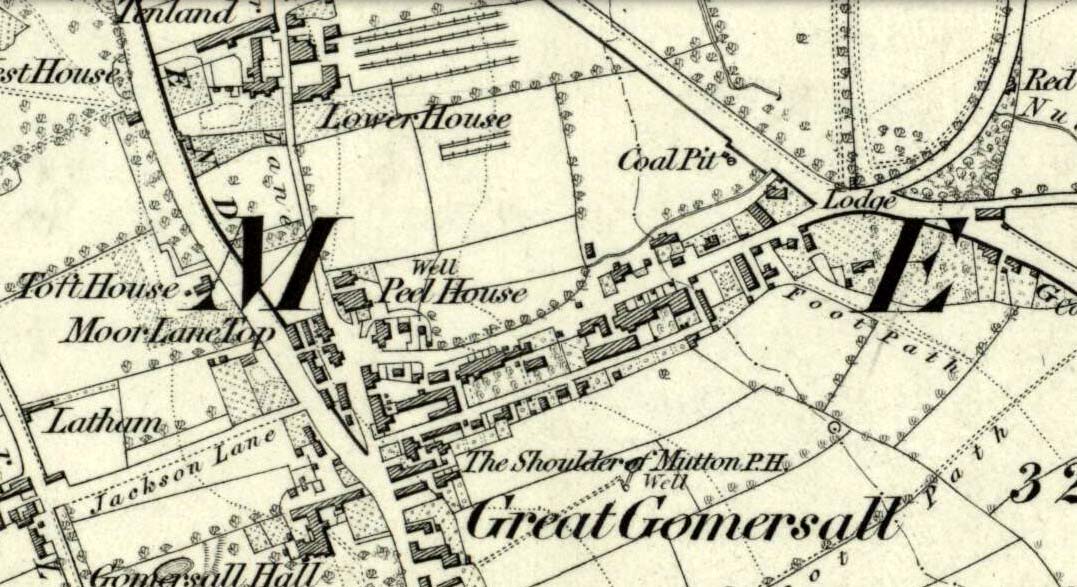
Not far from the old maypole, the Moor Lane Well was the innocuous-sounding site where legend told that a phantom horse was once seen running up and down the lane—said by old locals to be a “very ancient highway”. It was also a place where we find an intriguing tale of local disrepute, that brought humiliation to the culprit from the entire village.
There used to be a custom called ‘Riding the Stang’ which persisted in Yorkshire until the end of the 19th century. Thought to be of Scandinavian origin, it involved the culprit being hoisted onto a platform, held up by poles, then carried around the village where the person lived in a most ignominious procession. It was invariably described as being a public punishment and humiliation for faults made by one’s wife. Anyway, in the early 1840s, said H.A. Cadman (1930),
“there were two families who lived at Brecks Farm. I will not of course divulge their true names, so will describe one of them as the Jones family and the other as the Smith family. Jones’ wife accused Smith’s wife of having polluted the drinking water and the Smith family left the farm and removed to the top of Moor Lane. The Jones family wishing to make the most of the affair resolved that Mrs Smith’s effigy should ride the stang. A long pole was obtained and the effigy was affixed to the centre. Two men then took hold, one at each end, and walked up Moor Lane, folowed by a huge concourse of people. The procession stopped opposite Mrs Smith’s house and repeated the nominee. My informant, a dear old lady, would not tell me the whole of the verse, but it commenced thus:
“It’s neither your fault nor my fault that I ride this stang.”
“After all the verses had been repeated, the stang was taken round Gomersal, when ultimately the effigy was burned with the usual solemnities.
“The other instance of riding the stang occurred also in thge early ‘forties and I believe this was the last occasion of the stang being ridden. On this occasion a man…was in the habit of beating his wife harder than his neighbours thoughts proper with the result that he had to be punished. Now Jim was a most religious man, but the same rites had to be observed as in the other instance,
“It was for Jim Vasey that religious man
He paid her, he paid her indeed and
If Jim doesn’t alter his manners
We will take his skin “…….” to the tanners.
And if the tanner doesn’t tan it well,
We’ll send it to…”
“One must regret that the old custom of riding the stang has died out, as it must have had its good points.”
Local people could, of course, simply bring it back again! The Moor Lane Well was one of the main water supplies for the old villagers in bygone times, but seems to have disappeared under the modern houses. There is, however, a small narrow band of trees where the old waters once ran, amidst which it might still be found—if luck is on our side…
References:
Cadman, H. Ashwell, Gomersal, Past and Present, Hunters Armley: Leeds 1930.
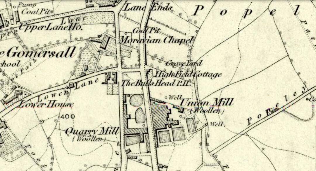
Originally called the ‘Manor Lea Well’ because it could be found on the far west of the land belonging to the Manor House, the name later became corrupted to ‘Mannerly’ by local folk. It was one of the four prime water supplies for this part of the old village, but it had other important social and festive rites attached that undoubtedly went back centuries. H.A. Cadman (1930) told that:
“On Palm Sundays it was the custom for boys to take bottles containing Spanish juice, treacle, and any other sweet thing they could, for the purpose of having them filled with the water from the well. The boys then exchanged bottles with each other and each sampled the others. It was said that no better water existed for this purpose.”
This particular ritual was integral to virtually every Spa Well from Wakefield through to the source of the River Calder.
A Mr G.W. Parker said that the well was to be found at the “extreme Western side” of Manor Lea and was “still in existence” when Cadman wrote about it in 1930, “behind Company Mill” not far from the Moravian Burial Ground. Do any local historians know if the well is still there, or has it since been destroyed?
References:
Cadman, H. Ashwell, Gomersal, Past and Present, Hunters Armley: Leeds 1930.
Holy Well (destroyed): OS Grid Reference – SE 3060 3373
Archaeology & History
Lady Lane, where the well was
Deep in the industrial centre of Leeds, not far from the main bus station, could once be found one of Yorkshire’s many ‘Lady Wells’. The great historian and antiquarian Ralph Thoresby (1715) was the first to write of this great spring, which is now lost beneath the concrete buildings near Quarry Hill. He described it as,
“a noted spring…to this day called Lady Well and the adjoining way, Lady Lane.”
In 1806 Edward Baines of Leeds described this spring of “soft, pure water,” also telling it to be on Lady Lane, saying that
“At the bottom of this street is a spring of excellent water, called Lady-Well, which affords a copious supply of that necessary article to this populous part of town.”
This Lady Well was also included in Andrea Smith’s (1982) survey, who noted that less than two hundred yards northwest of was The Chantry of Our Lady. This church has medieval foundations and its dedication would be derived from the healing waters here; plus, Smith notes, in West Yorkshire, “the number of churches dedicated to Our Lady is only two and these are both classed as ancient.”
Maypole (destroyed): OS Grid Reference – SE 2068 2672
Archaeology & History
As in countless villages and towns across the British Isles, Gomersal also once had its maypole near or at the village centre. We don’t know when the first maypole was erected in the village and many local sites were openly destroyed by rampant christian puritans and similar idiots. It stood not far from the Moor Lane Well and was described by the regional historian H.A. Cadman (1930), who told:
“The Maypole was at the top of Moor Lane and one can imagine the welkin echoing to the very old song:
‘Come lasses and lads take leave of your dads
And away to the maypole hie.
For every fair has a sweetheart there
And the fiddlers standing by.
For Willy shall dance with Jane
And Johnny has got his Joan.
To trip it, trip it, trip it, trip it,
Trip it up and down.’
Yet as with maypoles up and down the land, testosterone-fuelled Springtime fall-outs happened. Mr Cadman told:
“Very often May Day gatherings ended up with fights. Great jealousy always existed between the inhabitants of Great Gomersal, Little Gomersal and Spen. There is a tradition which has been handed down that the last Maypole in this district stood on Liversedge Green. This Maypole was demolished in a fight by the Gomersalians and there is a similar tradition about the Maypole on Cleckheaton Green, so as Mr Frank Peel says, “It is evident that ancient inhabitants of Gomersal were more pugnacious than their neighbours.” I have no evidence when the Gomersal Maypole ceased to exist, but there is abundant evidence to prove that there was one in Gomersal, the proof being that the vane is now in Batley Museum. It is in the form of a fish.”
If anyone has any further information on this important relic, or its history, please let us know.
References:
Cadman, H. Ashwell, Gomersal, Past and Present, Hunters Armley: Leeds 1930.
Healing Well (lost): OS Grid Reference – SE 209 260?
Archaeology & History
This bizarre-sounding well owed its name—if we are to accept H.A. Cadman’s (1930) version of history—to the local land-owner,
“Joseph Mortimer and it was so-called because Mortimer’s christian name was Doidy Poidy.”
But this seems unlikely. The term ‘doidy’ is a local dialect word, seemingly found only in West Yorkshire, meaning ‘an overdressed person, especially female,’ (Haigh 1928), with doidy-poidy being rhyming slang for the same thing. The english dialect magus, Joseph Wright (1900), proclaimed the same derivative, “a badly dressed woman, a dowdy.” So it may have been that this title was endowed upon Mortimer’s wife.
Cadman told that the Doidy Poidy Well was one of the “chief wells” of Gomersal, implying that its waters were good and strong. Its existence on what was known as “the old feasting grounds” may have played a part in the “public rejoicings which last for days… The feast was on the Monday on or before Lady Day.” (March 25th, around spring equinox) However, Cadman assures us that the celebrations were started “when the Gomersal Cloth Hall was opened,” telling us that “this feast or fair is not therefore an ecclesiastical one.”
The exact whereabouts of the Doidy Poidy Well remains a mystery (the map-link, above, shows an approximation from the middle of Gomersal).
References:
Cadman, H. Ashwell, Gomersal, Past and Present, Hunters Armley: Leeds 1930.
Haigh, W.E., A New Glossary on the Dialect of the Huddersfield District, Oxford University Press 1928.
Wright, Joseph (ed.), English Dialect Dictionary – volume 2, Henry Frowde: London 1900.
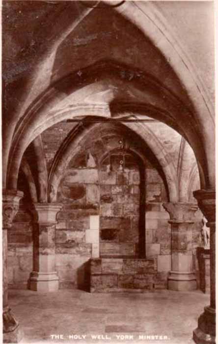
For people who like to visit the sacred sites that determined a cross-over from Earth-based animism to one which ceased sanctifying the Earth, this ancient water source in the cellars beneath York Minster would be a good example. Sadly, the church has closed off access to this ancient heritage and you can no longer see it. Yet despite the fact that the modern-day christians have closed off your encounter with this important heritage site (York Minster’s website doesn’t even mention its existence!), we should not forget its mythic history…
As you walk into the building (at some great expense, it has to be said), the location of the holy well is said to be at its more western end, albeit in the crypt underground—although there does seems to be some confusion with some authors about exactly where the well is positioned.
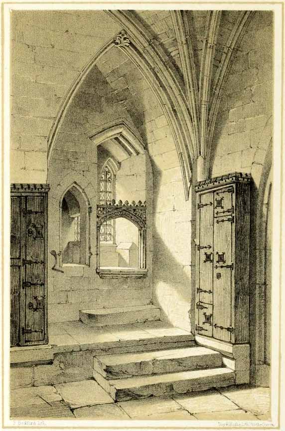
1850 sketch of the well
The earliest account we hear of the place relates to when the northern tribal King Edwin, along with his sons Osfrid and Esfrid, came here to be “baptized” in the waters of this clear spring “on Easter day, April 12, 627” CE. Immediately thereafter a small wooden chapel was constructed next to or above the well. From then on, as the centuries passed, the renown of the well grew and eventually the magnificent ritual temple of York Minster was eventually built. The waters eventually became dedicated to St. Peter and an annual festival occurred here soon after the Midsummer solstice on what became known as St. Peter’s Day (June 29). After the year 1462, a secondary festival date was also given to the site by the Church and another annual celebration occurred here on October 1 too. Its waters remained accessible to people for drinking, healing and rites throughout the centuries. It is only now, in the 21st century, that its sacrality and spirit has been closed-off. This is a situation that must be remedied!
In Mr Goole’s (1850) survey of York Minster, his architectural illustration of the building showed that the water from the well had been brought up onto the ground floor, on the southeast side of the inner cathedral building in the easternmost vestry, and named as St Peter’s Pump. This is illustrated in the 1850 drawing above-left.
A whole series of early writers mention the well in earlier centuries—of whom a brief sample is given here. When Celia Feinnes came here in the 17th century, she said that,
“In the vestry of York Minster there is a well of sweet spring water called St Peter’s Well ye saint of ye Church, so it is called St Peter’s Cathedral.”(Smith 1923)
Mr Torre (1719) gave it equal brevity, saying simply that,
“at the south-west corner thereof is a draw-well (called St. Peter’s Well) of very wholesome clear water much drunk by the common people.”
In R.C. Hope’s (1893) national survey of sacred wells, he told that
“There is a draw well with a stone cistern in the eastern part of the crypt of York Minster… The Crypt is about 40 feet by 35 feet.”
The well was even included in Murray’s Handbook to Yorkshire (1892) as being “in the southwest corner of the Minster.” William Smith (1923) included the site in his fine survey, telling his readers that,
“The water is excellent in quality, which in measure, so chemists say, is due to the lime washed into it by the rain from the walls of the Minster. The water has for centuries been used for baptisms, and is so used today. The well has now for some years been covered with a pump.”
Folklore
In Geoffrey of Monmouth’s famous early History, we find that King Arthur visited here. …And one final note, about which we know not for certain whether it was relevant to the holy well hiding in the crypt, but a fascinating heathen custom was enacted here in bygone days, almost above the spring. Mistletoe, as Christina Hole (1950) told,
“was ceremonially carried to the cathedral on Christmas Eve and laid upon the high altar, after which a universal pardon and liberty for all was proclaimed at the four gates of the city for as long as the branch lay upon the altar.”
Mistletoe is one element that is known to have been sacred to the druids (not the present-day druids!) and was sacred to the ancient Scandinavians (who came here), and also possessed the powers of life and death in its prodigious folklore and phytochemistry. Fascinating…
…to be continued…
References:
Bord, Janet, Cures and Curses: Ritual and Cult at Holy Wells, HOAP: Wymeswold 2006.
Just outside of Leek a right-hand lane leads to the small hamlet of Ashenhurst, turning left pass the gated road and on the right hand side at the next fork is the The egg well on the right in a small brick building.
Archaeology & History
The Egg Well is a curious site. No evidence appears to record it as a holy well, nor a spa— but it appears to be a secular healing well. Local tradition believes that the site was used by the Roman, but the older fabric was set in place by William Stanley, the owner of Ashenhurst Hall bewteen 1744 and 1752. The present house was erected in the 19th century.
Waters of the well
The name of the well is curious; it could refer to the shape of the basin, but could also refer to sulphurous waters although I could not detect a smell. Today, a rather ugly 19th century brick-built structure surrounds this stone lined bath-shaped structure, which was roofed at a later date.
Folklore
The site was used by the Romans, but there is no evidence. Its properties are recorded on the basin is this monogram and an interesting Latin inscription which reads:
“Renibus, et splenui cordi, jecorique medatur, Mille maelsi prodest ista salubris aqua.”
The translation being:
“The liver, kidneys, heart’s disease these waters remedy. And by their healing powers assuage full many a malady.”
References:
Parish, R.B., Holy Wells and Healing Springs of Staffordshire – in publication.
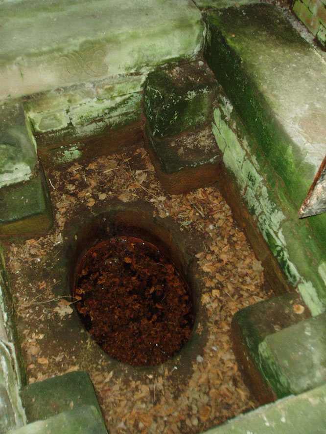
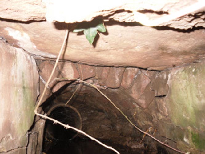
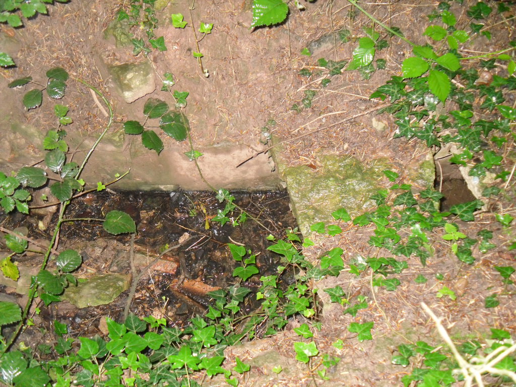
First mentioned in Pipe Rolls and referred to by the founder of Wallingwells Benedictine Priory (founded around 1150 CE) as ‘juxta fonts et rivum fontium’, the site Wallingwell or originally Waldon-by-the-Wells, may be significant. The name refers to ‘bubbling wells’, but whether these wells were dedicated appears to be unknown, although it does seem likely. Indeed, an anonymous article from the Worksop Guardian dated 1929 on the Wallingwell Estate, shows the well arising under a rough stone work arch beside the site of a lake. Close by, appears to be a grotto of a similar construction. The article states that the grotto was built 250 years (from 1929 this suggests a date of 1679 which appears a little too early for this folly, a date in the 18th century being more likely). This was done by Thomas White using stone from petrified springs in Derbyshire. No reference is made of the well, but one assumes that it was built at the same time, but whether White was constructing a folly around an existing traditional site again is unknown.
Baker (2000) refers to the castle folly but fails to reference these sites suggesting that it had vanished. However, grotto and well still exist in the overgrown and forlorn garden to the back of the house. The grotto is well-preserved, although signs of ruination are evident and the urn within has gone.
The internal brickwork
The overgrown well
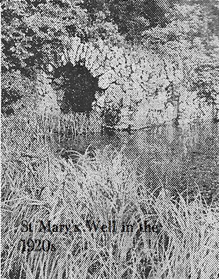
St. Mary’s Well is the most ruined. The archway appears to have fallen or been knocked down but the channel or basin the spring flows into still exists. Observation underneath a flattened stone covering the channel show that the spring flows from a pipe further up and under a series of neat brick arches. It is clear that the well structure was never accessible as it abutts onto the Lake, but was designed to be seen from the other side of the Lake. This view now is difficult due to the considerable plant growth obscuring the sites. It is good to see that the well still exists and hopefully the garden could be restored.
Extracted from R. B. Parish (2009) Holy Wells and Healing Springs of Nottinghamshire
From the village lane at the east end of Brook Street, take the footpath through the first gate and then over the stile into the woods on your left (north). Soon a clearing will appear on the left hand side as you climb the hill. Careful as you scramble down (look for a swing set up by local children) on the left hand side will be the Devil’s Pulpit.
Archaeology & History
The village name deriving from ‘Helmes’, the genitive singjular of the Old English masculine name Helm, or from helmes, the genitive singular of OE helm ‘a helmet, the summit of a hill, a shelter’, so that the name is either ‘Helm’s spring’ or ‘spring at the summit or shelter’—which does rather neatly defines its topography. However, other authorities suggest its gets its name from elm trees which once grew around the wells.
The site has an eerie but not unquiet atmosphere this is possibly due to the stone called the Devil’s Pulpit, a large approximately six-foot high piece of sandstone under which a small spring arises.
Folklore
This Thompson (1999) in his Lincolnshire Wells and Springs notes local opinion thought was St. Helen’s, he said it tasted sweeten than the other waters (a fact that I cannot testify as the spring has appeared to have almost dried up the year I went). Binnall (1845) notes that the spring wells were regarded as possessing curative powers and rags were hung on the surrounding bushes.
The dedication of St Helen is an interesting one and can be seen as an outlier from those found widely distributed in Yorkshire (Whelan & Taylor, 1989), but rare in the adjoining counties of Derbyshire and Nottinghamshire. Harte (2008) in his English Holy Wells suggests that the name is spurious; and Rudkin’s (1936) Lincolnshire Folklore does not refer to it as such. However, in support of the view, I had no problem locally detecting the well using this name in the village (incidentally Harte makes an error referring to the springs as Aisthorpe Springs, these are clearly another site). There was supposed to be a chapel or church associated with the site, of which there is no trace or record.
Taken from R. B. Parish (2012) Holy Wells and healing springs of Lincolnshire
References:
Cameron, Kenneth, The Place-Names of Lincolnshire – volume 6, EPNS: Nottingham 2001.
Harte, Jeremy, English Holy Wells, Heart of Albion: Loughborough 2008.
o’ Neill, Susanna, Folklore of Lincolnshire, History Press: Stroud 2012.
Rudkin, Ethel, Lincolnshire Folklore, 1936.
Thompson, Ian, Lincolnshire Springs and Wells: A Descriptive Catalogue, Bluestone: Scunthorpe 1999.
Whelan, Edna & Taylor, Ian, Yorkshire Holy Wells and Sacred Springs, Northern Lights: Dunnington 1989.
Holy Well (destroyed): OS Grid Reference – TQ 3096 8106
Archaeology & History
Close to the long-lost Strand Cross and long-lost Strand Maypole, in bygone centuries was also to be found a holy well of great repute, dedicated by early christians to the sea-faring St. Clement. Its presence was recorded in the ‘Holywell Street’ name at far the eastern end of The Strand but, like its compatriot monuments, it too is long-lost… Thankfully we have reasonably good accounts of its existence, although its precise whereabouts has been something of a matter of debate.
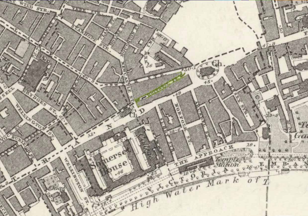
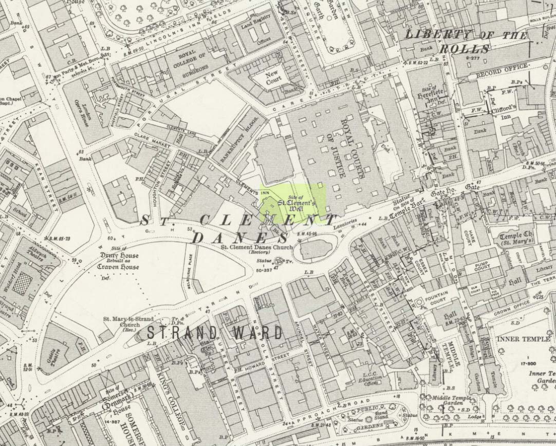
Holywell Street on 1868 mapSt Clements Well on 1914 map
The site is certainly of considerable antiquity, as evidenced in the early citations of the street-name ‘Holywell Street’. The earliest reference is found in legal records from 1373, where it was described as “viam regiam que vocatur Holeway“, or “the main road which is called the Holy way.” Several other references name the street as ‘Holwey’ and ‘Holewlane’, before it became shown as ‘Holliwell Street’ on the 1677 “Large and Accurate Map of the city of London” (I can find no copy of this on-line that allows for a reproduction of it on here, sadly). The following year, William Morgan cited it as being ‘Hollowell street’, but curiously the place-name writers Gover, Mawer & Stenton (1942) opted that the name derives from it being a ‘hollow way’ and not relate it to the holy well which we know was located at the far eastern end of the now-missing Holywell Street. I think they gorrit wrong on this occasion!
The best historical narrative of the site is undoubtedly that by Alfred Foord (1910), whose lengthy research waded through all the possible locations of the site, concluding in the Appendix of his work that, “in front of Clement’s Inn Hall…was the far-famed ‘holy well’ of St. Clement.” It’s best leaving Mr Foord to do all the talking on this one:
“The earliest mention of the well of St. Clement was made by the Anglo-Norman chronicler, FitzStephen, in his History of London, prefixed to his Life of Becket (written between the years 1180 and 1182), where in the oft-quoted passage, he describes the water as “sweete, wholesome, and cleere,” and the spot as being ”much frequented by scholars and youths of the Citie in summer evenings, when they walk forth to take the aire.”
“Turning to Stow (1598), a fairly correct idea of the position of the holy well may be formed from his remarks. Referring to Clement’s Inn, he defines it as “an Inne of Chancerie, so called because it standeth near St. Clement’s Church, but nearer to the faire fountain called Clement’s Well.” As to its condition at the time he wrote, he says: “It is yet faire and curbed square with hard stone, and is always kept clean for common use. It is always full and never wanteth water.” Seymour writes of it in his Survey of London (1734-35) as “St. Clement’s pump, or well, of note for its excellent spring water.” Maitland (1756) says of it: “The well is now covered, and a pump placed therein on the east side of Clement’s Inn and lower end of St. Clement’s Lane.” This appears to be the first specific reference to the change from a draw-well to a pump. Hughson (1806-09), and Allen (1827-29) both allude briefly to the well, but the following authors say nothing about it : Northouck, A New History of London (1773); Pennant, Some Account of London (1790 and 1793); Malcolm, Londinium Redivivum (1803-07); and Riley, Memorials of London and London Life in the Thirteenth, Fourteenth, and Fifteenth Centuries (1868).
“Among the more modern writers, John Sanders in his “Strand” article, published in Knight’s London (1842), says: “The well is now covered with a pump, but there still remains the spring, flowing as steadily and freshly as ever.”
“George Emerson (1862), in speaking of the Church, says: ”It stood near a celebrated well, which for centuries was a favourite resort for Londoners. The water was slightly medicinal, and having effected some cures, the name Holy Well was applied.”
“John Diprose, an old inhabitant of the parish of St. Clement Danes, in his account of the parish (published in two volumes in 1868 and 1876), has this passage on the subject: “It has been suggested that the Holy Well was situated on the side of the Churchyard (of St. Clement), facing Temple Bar, for here may be seen a stone-built house, looking like a burial vault above ground, which an inscription informs us was erected in 1839, to prevent people using a pump that the inhabitants had put up in 1807 over a remarkable well, which is 191 feet deep, with 150 feet of water in it. Perhaps this may be the ‘holy well’ of bygone days, that gave the name to a street adjoining.” Timbs says in his Curiosities of London (1853), “the holy well is stated to be that under the ‘Old Dog’ tavern, No. 24, Holywell Street.” Mr. Parry, an optician in that street, and an old inhabitant, held the same opinion. Mr. Diprose, on the other hand, finds “upon examination, no reason for supposing that the holy well was under the Old Dog tavern, there being much older wells near the spot.” Other inhabitants believe that the ancient well was adjacent to Lyon’s Inn, which faced Newcastle Street, between Wych Street and Holywell Street. In the Times of May 1, 1874, may be found the following paragraph, which reads like a requiem: “Another relic of Old London has lately passed away; the holy well of St. Clement, on the north of St. Clement Danes Church, has been filled in and covered over with earth and rubble, in order to form part of the foundation of the Law Courts of the future.” On the 3rd of September of the same year (1874) the Standard refers to this supposed choking up of the old well, and suggests that “there had been a mis-apprehension, for the well, instead of being choked up, was delivering into the main drainage of London something like 30,000 gallons of water daily of exquisite purity. This flow of water which wells up from the low-lying chalk through a fault in the London Clay, will be utilised for the new Law Courts.” A contributor to Notes and Queries (9th series, July 29, 1899) draws attention to the following particulars from a correspondent, a Mr. J. C. Asten, in the Morning Herald of July 5, 1899: “Having lived at No. 273, Strand, for thirty years from 1858, it may interest your readers to know that at the back of No. 274, between that house and Holy Well Street, there exists an old well, which most probably is the ‘Holy Well.’ It is now built over. I and others have frequently drunk the exceedingly cool, bright water. There was an abundance of it, for in the later years a steam-printer used it to fill his boilers.” An interesting account of another well, less likely, however, to be the true well, is given by the late Mr. G. A. Sala in Things I have Seen and People I have Met (1894), who describes the clearing of the well which was not under, but behind the ‘Old Dog,’ in Holy Well Street, where he resided for some months about 1840. One or two interesting things turned up, amongst them being a broken punch bowl, having a William and Mary guinea inserted at the bottom ; a scrap of paper with the words in faded ink, “Oliver Goldsmith, 13s. 10d.,” perhaps a tavern score, and a variety of other articles.
“The erection of the new Law Courts—1874-82—which, with the piece of garden ground on the western side, cover a space of nearly 8 acres, swept away numbers of squalid courts, alleys, and houses, including a portion of Clement’s Inn, where the well was. Further west another large area was denuded of houses, by which Holywell Street—demolished in 1901—and nearly the whole of Wych Street (a few houses on its northern side only being left), have been wiped off the map.
“In order, if possible, to obtain some corroboration of the Standard‘s statement that the spring existed in 1874, the writer applied for information on the point to the Clerk of Works 2 at the Royal Courts of Justice, who wrote that he could find no trace of St. Clement’s Well, so that the report in the Times (quoted above) is probably correct. The water-supply to the Courts of Justice, he adds in his letter of June 13, 1907, is from the Water Board’s mains, and an underground tank, used for the steam-engine boilers, situated between the principal and east blocks, is filled partly from the roofs and partly from shallow wells in the north (Carey Street) area of the building—the overflow running into the drains.
“On the Ordnance Survey Map, published in 1874, a spot is marked on the open space west of the Law Courts with the words “Site of St. Clement’s Well”: this spot is distant about 200 feet north from the Church of St. Clement Danes, and about 90 feet east of Clement’s Inn Hall, which was then standing. The Inn, with the ground attached to it, was disposed of not long after 1884, when the Society of Clement’s Inn had been disestablished.”
On the northeast side of the St. Clement’s church, a metal plaque was erected in 1807 (it’s still there!) which claims to be the position where the holy well existed. It reads:
“The well underneath, 191 feet deep, and containing 150 of water was sunk & this pump erected at the expense of the parish of St Clement Danes.”
In Mr Sunderland’s (1915) account of the Well, he told that it was located “200ft north” of the church, “covered by the Law Courts, built between 1874 and 1882”; and that although the waters here were clear and pure, they were “probably not medicinal”. Its waters, he said, fed the old Roman Spring Bath at No.5, The Strand.
In Edward Walford’s (1878) standard work, he told that,
“Round this holy well, in the early Christian era, newly-baptised converts clad in white robes were wont to assemble to commemorate Ascension Day and Whitsuntide; and in later times, after the murder of Thomas à Becket had made Canterbury the constant resort of pilgrims from all parts of England, the holy well of St. Clement was a favourite halting-place of the pious cavalcades for rest and refreshment.”
Folklore
Although I can find nothing specifically relating St. Clement’s Well with the old customs cited below, a connection seems highly likely, as the events started where Mr Foord (1910) said the holy well was located. The great english folklorist Christina Hole (1950) wrote:
“One of the most charming ceremonies in London is the Oranges and Lemons service at St. Clements Danes. It takes place every year on March 31st, or as near as possible to that date, and is a modified revival of an old custom which has only recently died out. In the lifetime of many elderly people now living, the attendants of Clements Inn used annually to visit all the residents of the Inn and present them with oranges and lemons, receiving some small gift in return. At the March service, the church is decorated with oranges and lemons, and all the children who attend are given fruit as they leave the building, while the bells play the old nursery rhyme. The oranges and lemons are supplied by the Danish colony in London, whose church this has been for many centuries, and are often distributed by Danish children wearing their national colours of red and white.”
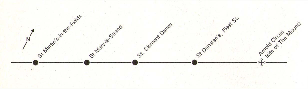
The historian Laurence Gomme (1912) propounded that the ancient stone cross of The Strand nearby, and the Strand maypole, were elements relating to an unbroken line of heathen traditions dating back to the early Saxon period—and the customs here cited would seem to increasingly validate this. A more detailed multidisciplinary analysis of this cluster of sites along The Strand by competent occult historians is long overdue.
The Strand ley (courtesy Paul Devereux)
One final thing: if the position of the Well is indeed the one cited on the 1807 plaque, to the northeast of St. Clement’s church, then it lies bang on the ley-line that was first propounded by Alfred Watkins (1922; 1925; 1927), and subsequently enlarged upon by Devereux & Thompson! (1979)
References:
Devereux, Paul & Thomson, Ian, The Ley Hunter’s Companion, Thames & Hudson: London 1979.
Foord, Alfred Stanley, Springs, Streams and Spas of London: History and Association, T. Fisher Unwin: London 1910.
Gomme, Laurence, The Making of London, Clarendon: Oxford 1912.
Gover, J.E.B., Mawer, Allen & Stenton, F.M., The Place-Names of Middlesex, Cambridge University Press 1942.
Hole, Christina, English Custom and Usage, Batsford: London 1950.
Johnson, Walter, Byways in British Archaeology, Cambridge University Press 1912.
Street, Christopher E., London’s Ley Lines, Earthstars: London 2010.
Sunderland, Septimus, Old London Spas, Baths and Wells, John Bale: London 1915.