Kipps, Linlithgow, West Lothian

Stone Circle (destroyed):  OS Grid Reference – NS 9909 7387

Also Known as:

  1. Canmore ID 47920

Archaeology & History

Site shown on 1856 map

In an Address to the Scottish Society of Antiquaries in the middle of the 19th century, Sir James Simpson (1862) pointed out the outright destruction and vandalism that incoming land-owners (english mainly, and probably christians too) had inflicted on the monuments of the Scottish people.  Stone circles and two cromlechs, he said, that had existed in this part of West Lothian for thousands of years, were recently destroyed when Simpson was alive.  One of them was here at Kipps.  He told:

“In 1813 the cromlech at Kipps was seen by Sir John Dalzell, still standing upright.  In describing it, in the beginning of the last century, Sir Bobert Sibbald states that near this Kipps cromlech was a circle of stones, with a large stone or two in the middle; and he adds, “many such may be seen all over the country.”  They have all disappeared; and latterly the stones of the Kipps circle have been themselves removed and broken up, to build, apparently, some neighbouring field-walls, though there was abundance of stones in the vicinity equally well suited for the purpose.”

Simpson suggested, quite rightly, that efforts should be made to resurrect the old monument.  In his day the fallen remnants of the ‘cromlech’ that had stood inside the circle were still in evidence and it was highlighted on the early OS-map of the region; and when the northern antiquarian Ratcliffe Barnett (1925) came walking here earlier in the 20th century he told he could still see “the remains of an ancient cromlech, which stood within a circle of stones.”  Around the same time, the Royal Commission (1929) lads looked for these remains but seemed to have gone to the wrong site, “a quarter-mile northwest of Kipps Farm”, where they nevertheless found,

“a tumbled mass of boulders containing about thirty stones, one being erect; they vary from 6 by 3 by 1½ feet by 4 by 3 by 2½ feet, and are probably the remains of a cairn.”

When the renowned chambered tomb explorer Audrey Henshall (1972) followed up the directions of the Royal Commission, she was sceptical of giving any prehistoric provenance to the rocks there, describing them simply as geological “erratics.”

The very place-names Kipps may derive from the monument, for as Angus MacDonald (1941) told, “the word seems to come from Gaelic caep, ‘a block’”, but the word can also mean “a sharp-pointing hill, a jutting point, or crag on a hill”, and as the house and castle at Kipps is on an outlying spur, this could be its meaning.

Folklore

Local lore told how lads and lassies would use the stones as a site to promise matrimony with each other, by clasping their hands through a gap on the top boulder.  Using holes in or between stones to make matrimonial bonds, where the stone is the witness to the ceremony, occurs at many other sites and became outlawed by the incoming christian cult, which took people away from the spirits of rock, waters and land.

References:

  1. Barnett T. Ratcliffe, Border By-Ways & Lothian Lore, John Grant: Edinburgh 1925.
  2. Duns, J., “Notes on a Burial Mound at Torphichen, and an Urn found near the ‘Cromlech’ at Kipps, Linlithgowshire”,  in Proceedings of the Society of Antiquaries, Scotland, volume 12, 1878.
  3. Henshall, Audrey S., The Chambered Tombs of Scotland – volume 2, Edinburgh University Press 1972.
  4. Lewis, A.L., “The Stone Circles of Scotland,” in Journal Anthropological Society Great Britain, volume 30, 1900.
  5. MacDonald, Angus, The Place-Names of West Lothian, Oliver & Boyd: Edinburgh 1941.
  6. Royal Commission on the Ancient & Historical Monuments, Scotland, Midlothian and Westlothian, HMSO: Edinburgh 1929.
  7. Simpson, James Y., “Address on Archaeology,” in Proceedings Society of Antiquaries, Scotland, volume 4, 1862.

Acknowledgements:  Accreditation of early OS-map usage, reproduced with the permission of the National Library of Scotland.

© Paul BennettThe Northern Antiquarian


Marriage Well, Carmyle, Lanarkshire

Sacred Well:  OS Grid Reference – NS 66765 62063

Getting Here

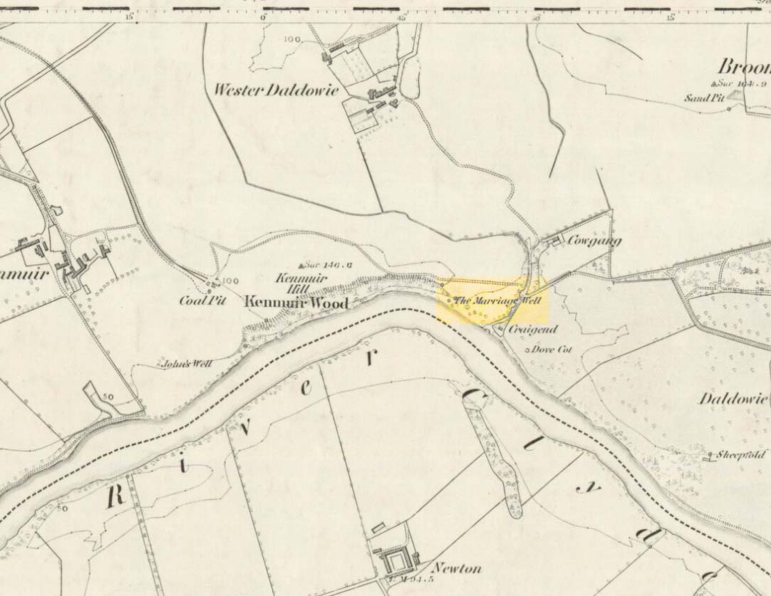
Marriage Well on 1864 map

Get onto the A763 road several miles east of Glasgow city centre and go along Gardenside Avenue onto the Carmyle estate. A few hundred yards on, turn right down Carmyle Avenue, then left onto River Road. Follow the footpath along the edge of the River Clyde for nearly a mile—past the recently destroyed John’s Well—until you hit the remnants of Kenmuir Woods. You’ll reach some large polluted pools and when you reach the gap between the first and second pool, walk into the trees above the river and the Well is there.

Archaeology & History

The decaying remains of this old well can still be seen, incredibly, in the small copse of trees that are Kenmuir Woods, just a few yards above the River Clyde, 160 yards below the M8 and the same distance west of the Daldowie sewage treatment works, with polluted water treatment pools just yards away!  Not the sort of place you’d take a partner for any sort of marriage ceremony whatsoever nowadays!  But it wasn’t always like this of course. Only since the Industrialists stamped their mark…

When Hugh MacDonald (1860) wrote the finest narrative of this arena in the middle of the 19th century, his evocative words painted the entire landscape with a veil untouched since his days.  Indeed, it is truly like another world compared to the sacrilege of what we see today:

“It is a wild and bosky scene, covered with a picturesque profusion of timber, and is the habitat of flowers innumerable. The weaver herbalists of Camlachie and Parkhead find it a perfect storehouse of medicinal rarities; and on Sundays they may be seen in sickly groups prying into every green recess in search of plants which old Culpepper would have loved for their rare qualities, or carrying them home in odorous bundles, confident of having obtained a mastery over “all the ills that flesh is heir to.” The botanist may also occasionally be seen lurking here, vasculum in hand, or on bended knee, examining the structure of some strange flower. But even the mere general lover of flowers will here find much to reward his attention.  At present the May-flower (Caltha palustris), the wild hyacinth, the craw-flower of Tannahill, the red campion (Lychnis dioica), the odorous woodruff (Asperula oderata), the globe-flower or lucken gowan (Trollius europœus), and many others are in full bloom, and so thickly strewn that even as the poet says, “You cannot see the grass for flowers.”

“At the foot of the bank, near its upper extremity, there is a fine spring, which is known by the name of the ‘Marriage Well,’ from a couple of curiously united trees which rise at its side and fling their shadows over its breast. To this spot, in other days, came wedding parties, on the day after marriage, to drink of the crystal water, and, in a cup of the mountain-dew, to pledge long life and happiness to the loving pair whom, on the previous day, old Hymen had made one in the bands which death alone can sever.  After imbibing a draught of the sacred fluid from the cup of Diogenes, we rest a brief space on the margin of the well.”

One wonders how far back in time the attribution of ‘Marriage Well’ from the animism of the trees went; and whether marriage ceremonies were performed here, quietly, away from the prying eyes of the Church and invading english in centuries much earlier under the guidance of the Moon.  It’s probable…

Nature’s cloak was still intact here when, many years after Hugh MacDonald’s visit, the local writer Dan McAleer (1930) informed us that,

“Shy bridesmaids and their groomsmen used to visit after a wedding to drink the mystic waters of the Marriage Well.  Certain places about the woods were well adapted for picnics, etc. After tea and refreshments the lads and lassies passed hours in amusement trying to step over the well and anyone soiling the water in any way while stepping across it would not get married that year.”

Much of the beauty of the landscape and Her waters, and the rich romance that arises from Her cyclical forms are long gone from here now… Cold ‘progress’ bereft of the necessity of Nature’s sanctity is no progress at all…  Although the genius loci of the place may have long since gone, at the very least the regional council—or decent locals, if the council can’t be arsed—could erect some memorial and save the failing Marriage Well from what seems to be its close and final demise….

References:

  1. Carpenter, Edward, Civilization: Its Cause and Cure, George Allen & Unwin: New York 1914.
  2. McAleer, Dan, A Sketch of Shettleston, 1930.
  3. McDonald, Hugh, Rambles round Glasgow, John Cameron: Glasgow 1860.
  4. Michell, John, The Earth Spirit: Its Ways, Shrines and Mysteries, Thames & Hudson: London 1975.
  5. Michell, John, Simulacra, Thames & Hudson: London 1979.
  6. Morris, Ruth & Frank, Scottish Healing Wells, Alethea: Sandy 1982.

© Paul Bennett, The Northern Antiquarian