Abbey Cross, Whitby, North Yorkshire

Cross:  OS Grid Reference – NZ 90242 11300

Getting Here

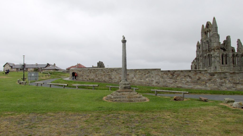
Pretty easy to find: from Whitby town centre, head uphill to the great ruins of Whitby Abbey.  You go past Caedmon’s Cross and past the more recent church and graveyard to the car-park at the top, outside the abbey.  At the edge of the car-park on the grass, you’ll see this tall hard upright, nice and erect!

Archaeology & History

Cross shown on 1894 map

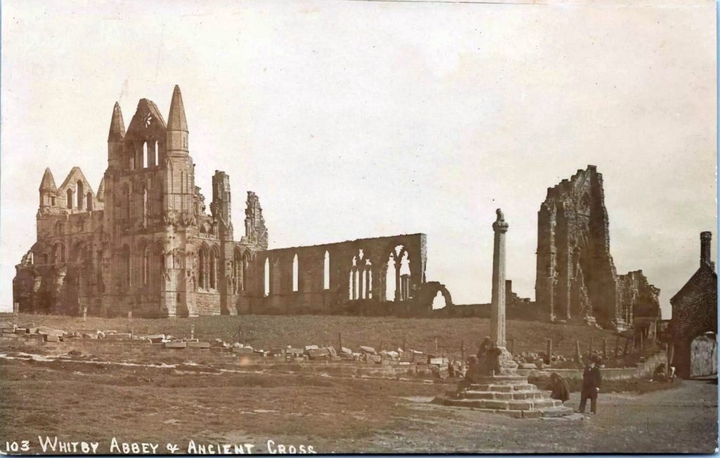
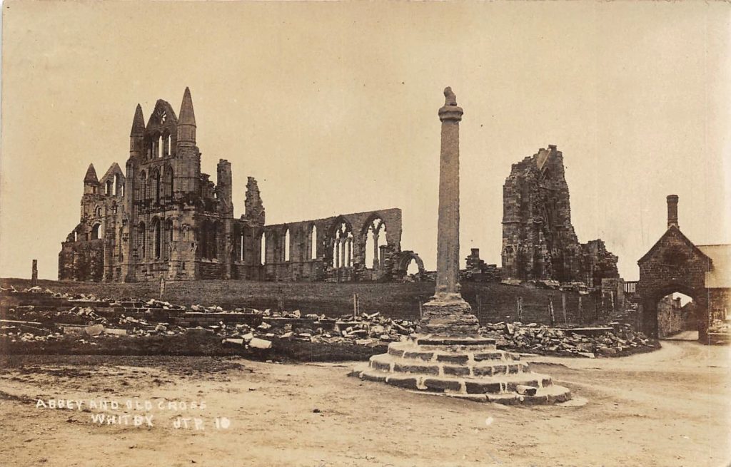
Highlighted on the earliest OS-maps and not to be confused with the nearby and more modern Caedmon’s Cross, this tall large monolith stands upon a stepped plinth comprising of six steps (originally five), about 18 feet high.  The top of the cross was knocked off a century or two ago, when it was reported to have been twenty feet!  Initially it stood about fifty yards closer to the Abbey, but was removed to its present position following the Dissolution. 

The brief history regarding its origin was described in George Young’s (1817) major work, in which he told that in 1474, on John Nightingale, rector of Sneaton parish, in his will “appointed his burial to be on the north side (of the Abbey), before the cross,” which was already standing at that time.  Young wrote:

“By this it would appear that the ancient cross, now standing in the abbey plain was then within the cemetery of the abbey.”

Abbey Cross, c.1900
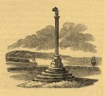
Young’s 1817 sketch

This has subsequently been taken as the standard regarding its origin.  Tradition also told that it was an old market cross, but this was treated with considerable scepticism by George Young, who believed that the monks here simply wouldn’t have allowed such a thing at the edge the abbey and burial ground.  He found evidence to indicate that it “was at the port or harbour of Whitby that corn was bought or sold, that here were kept the standard bushels for measuring corn, and that here the market-clerk had his station.”  In spite of this, T.H. Woodwark (1934) reported that fairs had been held at the cross early in the 20th century.  In a thoroughly profane way, electrical wiring was wrapped around the bottom of the cross and led to a generator, along with washing-lines running from it to a caravan!  Mr Young would have been apoplectic!  

References:

  1. Atkinson, J.C., Memorials of Old Whitby, MacMillan: London 1894.
  2. Holt, Robert B., Whitby, Past and Present, Copas: London 1890.
  3. Woodwark. T.H., The Crosses on the North York Moors, Whitby Literary & Philosophical Society 1934.
  4. Young, George, A History of Whitby and Streonshalh Abbey (2 volumes), Clark & Medd: Whitby 1817.

Acknowledgements:  Massive thanks to Lindsay (wherefore art thou…?) Mitchell for getting us up here…  Huge thanks for use of the Ordnance Survey map in this site profile, reproduced with the kind permission of the National Library of Scotland

© Paul BennettThe Northern Antiquarian

The map could not be loaded. Please contact the site owner.
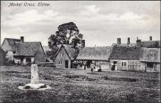
Market Cross, Elstow, Bedfordshire

Cross:  OS Grid Reference – TL 04864 47498

Archaeology & History

Elstow’s old cross, c.1900

Sitting quietly “on the village green, where the fair is still held,” wrote Wigram (1885), “stands the base of the old market-cross, reduced to a shapeless stump, but still bearing traces of leaden setting.”  Thought to be mediaeval in age, it was described as a sundial on some of the early Ordnance Survey maps which, perhaps, it may have been used as for a short period (although records are silent on the matter).  Standing just three-feet tall, this old stone pillar still lives on its ancient spot, as quiet as always, keeping itself to itself…

References:

  1. Wigram, S.R., Chronicles of the Abbey of Elstow, Parker & Co.: Oxford 1885.

© Paul BennettThe Northern Antiquarian

The map could not be loaded. Please contact the site owner.

Cross Well, Dundee, Angus

Healing Well (destroyed):  OS Grid Reference – NO 4032 3025

Archaeology & History

This old water supply had no direct ‘holy’ nature, despite its proximity to the cathedral, the old market cross and St Clement’s Well some fifty yards away!  Most odd.  A much more mundane story lies behind this long lost water source.  The Dundee historian William Kidd (1901) told us,

“When the public wells were erected, about the year 1749, to supply the town with water from the Lady-well reservoir at foot of Hilltown, one was placed on the High Street, on the east side of the Cross, and was called the Cross Well.”

It didn’t have too long a life either—much like the old Market Cross, for,

“In the year 1777 that quaint structure was demolished.  The platform and octagonal tower were carted away as rubbish, the least decayed stones being selected to be used in other buildings.  The stone shaft, also, was preserved, and placed beside the Old Steeple. With the demolition of the Cross, the Cross Well was cleared away from the High Street, but, as water was an essential to the people, the well was re-erected behind the Town House in St. Clement’s Lane.  In that situation it remained for nearly one hundred years, when, being rendered unnecessary by the introduction of the Lintrathen water supply, it was also demolished, along with the old buildings in the Vault and St. Clement’s Lane, to make room for the additions to the Town House.”

References:

  1. Colville, A., Dundee Delineated, A. Colville: Dundee 1822.
  2. Kidd, William, Dundee Market Crosses and Tolbooths, W. Kidd: Dundee 1901.

© Paul BennettThe Northern Antiquarian

The map could not be loaded. Please contact the site owner.

Town Cross, Kendal, Westmorland

Cross (destroyed):  OS Grid reference – SD 5152 9280

Also Known as:

  1. Cold Stone
  2. Market Cross

Archaeology & History

Not to be confused with the carved cross fragments held in the local church, this old town cross has long since gone.  It’s existence was recorded by the great Kendal historian Cornelius Nicholson (1861), but even in his day, this “obstruction” as he called it, was no longer standing.  Known as the local Market Cross where all the wheeling and dealing took place—official ones, as well as the not-so-official works of local folks—it stood just off Stricklandgate,

“opposite the Covered Market, and was an obstruction in the street.  There still remains a remnant of it in a stone at the corner, vulgarly called “cold stone,” where the charters and so forth were usually proclaimed.  Cold stone is a corruption of “call stone;” an appendage common to most ancient towns, where all public matters were “called” prior to the “institution” of belman.”

This folk etymology of “cold” needs to kept in mind when we come across other stones of this name.  …The earliest record of a market held at Kendal is from 1402, but written records of the Market Cross are scant until 1714. Such edifices tend to be architecturally ornate, but we have neither sketches nor descriptions of this lost site and must await the work of fellow researchers who may hopefully find out more.

References:

  1. Nicholson, Cornelius, The Annals of Kendal, Whitaker & Co.: London 1861.
  2. Smith, A.H., The Place-Names of Westmorland – volume 1, Cambridge University Press 1967.

© Paul BennettThe Northern Antiquarian

The map could not be loaded. Please contact the site owner.
Barley Cross, Richmond, North Yorkshire

Cross (destroyed):  OS Grid Reference – NZ 1709 0085

Archaeology & History

This was one of at least four old stone crosses that used to exist in Richmond.  It was accompanied by other functional edifices nearby known as the Oat Cross and Wheat Cross.  Like its companions, the Barley Cross is thought to have been the site where this grain was traded.  An early reference to it is Chris Clarkson’s (1814) survey, where he told us that not far from the old Market Cross,

“was formerly another, which went by the name of Barley Cross, perhaps so named from that sort of corn being sold there: it was a lofty Pillar of one large stone upon a small flight of steps with a cross at the top: rings were fastened to it, where criminals were punished by whipping: it is not long since it was taken down.”

Barley Cross (centre left) on 1724 town plan

Similar punishments were also administered to people at the original old Market Cross.  The grand masters of of Yorkshire history, Edmund Bogg (1908) and Harry Speight (1897) also mentioned this antiquity, but added nothing more.

The cross was highlighted on a 1724 plan of Richmond, just below the larger Market Cross.  In 1780 the local council ordered it to be demolished and, at a later date, large weighing scales were erected on the spot next to where it had stood, on the south-west side of the Trinity Church in the market square.

References:

  1. Bogg, Edmund, Richmondshire, James Miles: Leeds 1908.
  2. Clarkson, Christopher, The History of Richmond, T. Bowman: Richmond 1814.
  3. Home, Gordon, Yorkshire Dales and Fells, A. & C. Black: London 1906.
  4. Speight, Harry, Romantic Richmondshire, Elliot Stock: London 1897.

© Paul BennettThe Northern Antiquarian

The map could not be loaded. Please contact the site owner.
Market Cross, Harewood, West Yorkshire

Cross (destroyed):  OS Grid-Reference – SE 3224 4498

Archaeology & History

A Charter in the time of King John allowed for markets to be held in Harewood from 1209 CE onwards, “on the first day of July and the two following days, and also to hold one market there every week on the Monday.”  But whether or not a market cross was erected that far back, we don’t quite know.  Certainly, the edifice illustrated by John Jones (1859) in his standard work on Harewood didn’t date from such an early period!  It stood close to the old road junction to Wetherby in old Harewood village, “a little below the intersection of the roads, and about fifty yards higher up than the market house.” Jones told us:

Harewood Cross (Jones 1859)

“It stood upon a large stone pedestal, and was approached by a quadrangular flight of seven steps, very broad, where the neighbouring farmers used to stand, and dispose of their butter, fowls, eggs, &c.  It was re-erected, AD 1703, by John Boulter, Esq., and in the year 1804, when the road was lowered, it was taken down and destroyed.  This is to be regretted, it might have been re-erected in another situation, if that was inconvenient, and would have been in the present day, not only an ornament to the village but a relic of the past, of which the villagers might have been justly proud.  On the top of this cross there was a knur and spell, a game for which the village was celebrated in old times, while close to the toll booth there was a strong iron ring fastened to a large stone, where the villagers used to enjoy the barbarous amusement of bull baiting.”

References:

  1. Bogg, Edmund, Lower Wharfeland, J. Sampson: York 1904.
  2. Jones, John, The History and Antiquities of Harewood, Simpkin Marshall: London 1859.
  3. Speight, Harry, Lower Wharfedale, Elliott Stock: London 1902.

© Paul BennettThe Northern Antiquarian

The map could not be loaded. Please contact the site owner.
Market Cross, Hastings, Sussex

Cross (destroyed):  OS Grid Reference – TQ 828 099

Also Known as

  1. North End’s Cross

Archaeology & History

This long-lost stone cross should not be confused with the more recent one, erected by one Mr H. C. Richards in 1901 to commemorate some malarky about Edward VII.  The one in this profile was much older than that, although both of them were erected close to each other.  The older cross was found, said T.H. Cole (1884), “at the head of the Town, near All Saints’ Church.” Also known as the North End’s Cross, the old market was held here and close by were the gallows, the whipping post and the stocks.

References:

  1. Cole, Thomas H., The Antiquities of Hastings and the Battlefield, Hastings St Leonards Phil. Society 1884.

© Paul BennettThe Northern Antiquarian

The map could not be loaded. Please contact the site owner.

Market Cross, Aynho, Northamptonshire

Cross (destroyed):  OS Grid Reference – SP 514 332

Archaeology & History

In John Bridges’ (1791) account of the parish of Aynho, he made mention of an old market cross that stood in the village, but even in his day it had been removed and so we know little about it.    Chris Markham (1901) included it in his inventory of crosses, but could find no additional details to those provided by Mr Bridges.  He told us:

“In the seventeenth year of Edward II (1323-4) John de Clavering was lord of the manor of Eynho, and obtained the King’s charter for a weekly mercate, or market, to be held every Tuesday, and a yearly fair on the vigil and day of St. Michael and two days following.  This market was continued until the twentieth year of James I (1622-3), when Richard Cartwright obtained a new charter for holding the market and fair, with the addition of another yearly fair on the Monday and Tuesday after Pentecost.  Bridges, however, writing about 1700, says that the market had been discontinued for some sixty years, and that the market cross had been then long since taken down. Since then the fairs have also sunk into desuetude.”

References:

  1. Bridges, John, The History and Antiquities of Northamptonshire – volume 1, T. Payne: Oxford 1791.
  2. Markham, Christopher A., The Stone Crosses of the County of Northampton, Simpkin Marshall: London 1901.

© Paul BennettThe Northern Antiquarian

The map could not be loaded. Please contact the site owner.

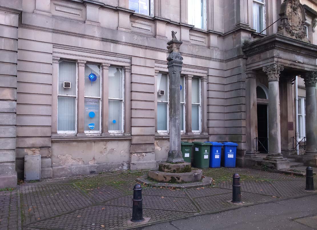
Town Cross, Alloa, Clackmannanshire

Cross:  OS Grid Reference – NS 88559 92686

Also Known as:

  1. Burgh Cross
  2. Canmore ID 47169
  3. Market Cross
  4. Mercat Cross

Getting Here

Alloa Cross, Bank Street

Get into the small town of Alloa, where the buses stand at Shillinghill.  From here walk southwest down Mill Street, which runs into Bank Street.  Keep your eyes peeled on your right-hand side, where outside one of the old municipal buildings you’ll see it standing upright.

Archaeology & History

Although now standing against the old buildings halfway down Bank Street, Alloa’s Mercat or Burgh Cross was initially set up at the crossroads 162 yards (148m) away, where Mar Street meets Mill Street and Bank Street.  It was moved to its present position sometime in the 1880s and knowledge of its early history is scant.

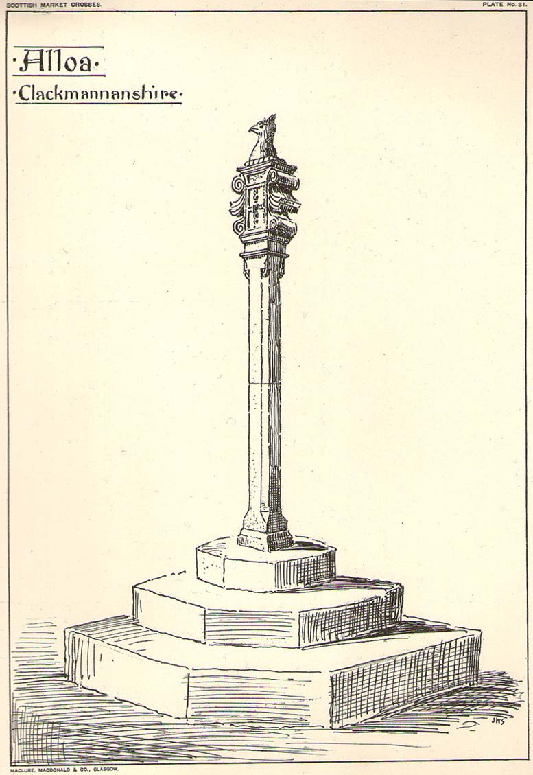
John Small’s sketch of Alloa Cross

Standing some 10 feet tall, the monument was described in John Small’s (1900) rare magnum opus, where he details the architectural features of the monument, telling:

“The shaft, which rests on a base and three steps, is of the usual square section, with splayed angles, stoped at top and bottom, the top stop being rather peculiar.  The head of the Cross is composed of an oblong stone set upright, characteristic of the late type seen in Keikleour and Kinrossie.  The oblong is ornamented at the sides with debased volutes and acanthus leaves, the whole crowned by a wreath from which rises a griffin’s head, part of the supporters of the Arms of the Lords of the Manor, Lord Mar and Kellie.”

References:

  1. Anonymous, The Alloa Illustrated Family Almanac, MacGregor & Steedman: Alloa 1887.
  2. Mair, Craig, Mercat Cross and Tolbooth, John Donald: Edinburgh 1988.
  3. Royal Commission on the Ancient & Historical Monuments, Scotland, Inventory of Monuments and Constructions in the Counties of Fife, Kinross and Clackmannan, HMSO: Edinburgh 1933.
  4. Small, John W., Scottish Market Crosses, Eneas Mackay: Stirling 1900.

© Paul BennettThe Northern Antiquarian

The map could not be loaded. Please contact the site owner.

Thursday Market Cross, York, North Yorkshire

Cross (destroyed):  OS Grid Reference – SE 603 519

Archaeology & History

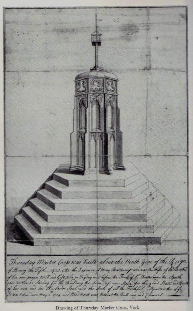
Early drawing of York’s Market Cross

This old cross was demolished long since, but I think it’s important to rejunevate a memory of its existence back into our times.  Little has been written about the site as it was destroyed more than 200 years ago and images of the edifice are rare indeed!  It was found near the modern centre of the city and although this ornate-looking thirty-foot tall cross was obviously impressive, an even earlier upright stone stood here in the 13th and 14th century.  But this new carved monument took precedence over its older and lesser upright.  First described — I think! — by Thomas Gent (1730), he told us that,

“The old cross stood towards the Kennel, against the middle of the market.  The lower part was an octagon, had an ascent of six high steps, covered with Tyles for Butchers, higher up with nitches, in which had been effigies and a small pillar above with four Dials and over them a Fane.”

A few years later when Francis Drake (1788) described the same monument, he added very few extra details; though told us it had five steps and not six — but this seems to have been an error on his behalf.  In C.B. Knight’s (1944) work we have what seems to be the most complete historical description of this lost stone edifice.  He wrote:

“In 1429 a new stone cross had been erected in Thursday Market in place of its predecessor by Marion Braythwayt, widow of John Braythwayt, who was Lord Mayor in 1394… This Cross was described by a writer in 1683 as “a fair Cross of stone, built upon the ascent of five steps, and hath neatly cut in stone a turret or battlement eight square, upon which is placed a round pillar with a four-square stone upon the top, which hath a sundial placed upon every square, and a vane above.  The Cross hath a penthouse round about it, covered over with tile, to shelter the market people in rainy weather, and is supported upon eight posts, upon one of which, on the south side, is fixed an iron yard-wand, the standard measure of the market.”  In 1705 the ancient Market Cross…was pulled down.”

References:

  1. Cobb, Gerald, “Note on a Drawing of Thursday Market Cross, York,” in The Antiquaries Journal, 43:1, 1963.
  2. Davies, Robert, Walks about the City of York, Nichols & Sons: Westminster 1880.
  3. Drake, Francis, Eboracum; or the History and Antiquities of the City of York, Wilson & Spence: York 1788.
  4. Gent, Thomas, The Antient and Modern History of the Famous City of York, Thomas Hammond: York 1730.
  5. Knight, Charles Bruton, A History of the City of York, Herald: York & London 1944.

© Paul Bennett, The Northern Antiquarian 

The map could not be loaded. Please contact the site owner.