Mineral Well, Upper Norwood, Surrey

Healing Well (destroyed):  OS Grid Reference – TQ 318 703

Archaeology & History

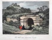
This was one of several so-called mineral springs in and around the Norwood area, but seemingly the least well-known—certainly in literary terms.  Whatever renown it may once have had was overwhelmed by the relative proximity of the much more famous curative waters of the Beulah Spa, a few hundred yards to the southeast.  It was mentioned, albeit briefly and already in the past tense, in John Anderson’s (1898) survey, when he told that “There used to be (a) mineral well at Biggin Hill. It is marked on the Croydon Inclosure Map” of 1800 and shown as a “Spring”, north of Biggens Farm.  It seems that it had only just been destroyed when Anderson wrote about it, as the research of Alfie Foord (1910) showed. His inquiries found that,

“There used to be another mineral well about half a mile to the north-west of Beulah Spa, at Biggin Hill, the water from which gushed up at the rate of seven gallons a minute.  In 1898 it was closed.  The subjoined analysis of water from a well, which is at White Lodge, Biggin Hill, formerly the residence of Mr. H. Wilson Holman, was kindly supplied by him to the writer in 1907.  This well, he says, undoubtedly taps the same spring that used to come out at the bottom of Biggin Hill, and which was blocked by the sanitary authorities in 1898.  The site of the spring was beyond the small tenement houses at the bottom of the hill, and there is still some masonry in existence—the end of the culvert where the water used to run out into a pond.  The reason of its being blocked was that it is alleged to have poisoned some domestic animal.”

References:

  1. Anderson, John C., The Great North Wood, Blades: London 1898.
  2. Foord, Alfred Stanley, Springs, Streams and Spas of London: History and Association, T. Fisher Unwin: London 1910.
  3. Gover, J.E.B., Mawer, A. & Stenton, F.M., The Place-Names of Surrey, Cambridge University Press 1934.

© Paul BennettThe Northern Antiquarian

Maiden’s Well, Launceston, Cornwall

Holy Well (destroyed):  OS Grid reference – SX 3285 8477

Archaeology & History

Site of well on 1884 map

Very little is known about this holy well on the north-western side of town that was apparently destroyed sometime in the 19th century; for when the Ordnance Survey lads visited here in 1882, they found no running water but only the location of where it had been and they indicated this on their 1884 map of the area, marked as “Site of.”

It was first mentioned in a short topographical notice in 1582, which told that the “Magden Well in the Quarrie Haye”—along with another well—was “found to be in decay.” (Peter 1885)  Then, when the Ordnance Survey lads resurveyed the area again in 1951, once more they could find no trace of it.

References:

  1. Peter, Richard, The Histories of Launceston and Dunheved, W. Brendon: Plymouth 1885.

Acknowledgements:  Big thanks for use of the early edition OS-map in this site profile, Reproduced with the kind permission of the National Library of Scotland

© Paul BennettThe Northern Antiquarian

Holy Well, Lawhitton, Cornwall

Holy Well:  OS Grid reference – SX 3546 8252

Archaeology & History

Site shown on 1882 OS-map

Highlighted on the 1882 OS-map several hundred yards north of St. Michael’s church, this site seems to have fallen back to Earth as no remains of it have been found in recent visits.  It was described in Charles Henderson’s (1914) notes as the “holy well at Barton Farm”, and was visited by J. Meyrick (1982) in April of 1980, who told that it could be found by taking “the track immediately east of Lawhitton church which runs through the farm of Mr Lancaster…  After going through the yard proceed ¼ mile down track to the valley where you reach a stream and the Well is on the right.”  It was sought after by Cheryl Straffon (1998) but following her visit to find the Well she told that “there was nothing now to see except a kind of natural basin by the small bridge.”

References:

  1. Henderson, Charles, Notebooks of Parochial Antiquities, Unpublished MS 1914.
  2. Meyrick, J., A Pilgrims Guide to the Holy Wells of Cornwall, Falmouth 1982.
  3. Straffon, Cheryl, Fentynyow Kernow: In Search of Cornwall’s Holy Wells, Meyn Mamvro: Penzance 1998.

Acknowledgements:  Big thanks for use of the early edition OS-map in this site profile, Reproduced with the kind permission of the National Library of Scotland

© Paul BennettThe Northern Antiquarian

Hawksworth Spring (01), Hawksworth, West Yorkshire

Cup-and-Ring Stone:  OS Grid Reference – SE 15767 41195

Getting Here

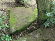
Looking down on the stone

Through Baildon town centre, take the road onto Baildon Moor, but instead of turning left up to Baildon Hill, keep straight on the Hawksworth road and 100 yards along you’ll see a car-park is on the right-hand side, just before you start going downhill.  From here, walk down the road a couple of hundred yards until you see the footpath (keep your eyes peeled!) turning right towards The Whitehouse, and from there take the footpath dead straight down to the woods below.  Cross the stream, turn right, then immediately left uphill by the wall-side.  Shortly before reaching the top you’ll see a large triangular sloping slab of rock with a tree at its top.  That’s it!   Alternatively you can come via Hawksworth village by following the directions to the Hawksworth Spring (02) carving, which is just 10 yards east of this one.  Easy!

Archaeology & History

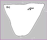
Sketch of carving (after Hedges 1986)
Note the faint cup, top-right

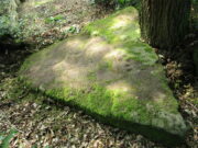
This minimalist design is best seen from above the adjacent rock which, in times gone by, was attached to this very same stone.   The main aspect of the carving are the two short rows of three cups, running almost alongside each other, in a likeness which my compatriot Liz Sykes said “was like some animal footprints.” It’s not a bad description to be honest (this same motif is found on a companion petroglyph just a few yards to the east: the Hawksworth Spring [2] stone).  If you follow the direction of the “animal tracks” to the western end of the stone, you’ll see another isolated cup with a faint incomplete ring around it.  You can just make it out on the photo to the right.  Another single cup-mark seems apparent two-thirds the way down the stone.

References:

  1. Hedges, John (ed.), The Carved Rocks on Rombalds Moor, WYMCC: Wakefield 1986.

Acknowledgements:  Huge thanks to Liz Sykes for her renowned cleaning skills!

© Paul BennettThe Northern Antiquarian

Scout Willie’s Well, Idle, Bradford, West Yorkshire

Healing Well (destroyed):  OS Grid Reference –SE 1672 3866

Archaeology & History

Along the footpath below the family graveyard at Thackley, the great genealogist and industrial historian J.H. Turner (1878) told that, “at the right hand side of the wood, at the bottom, is Scout Willie’s Well, formerly noted for its medicinal properties” – though whatever curative aspects it possessed have long since been forgotten.  It was also known as the Sweet Willie Well.  I perused the woodlands here searching for the well in my younger days but could find no trace of it; nor is anything shown on the early OS-maps of the area.  

References:

  1. Turner, J. Horsfall, Idle Upper Chapel Registers and Graveyard Inscriptions, Bingley 1878.

© Paul BennettThe Northern Antiquarian

Organn Well, Pontefract, West Yorkshire

Healing Well (destroyed):  OS Grid Reference – SE 45 21

Archaeology & History

The waters of the once-renowned Organn Well goes down in history as being one of the first wells in Britain whose waters were used in a town pump.  Written minutes from an early council meeting described how people gathered in the market place to discuss the objective of making such a pump in the times of Queen Elizabeth 1, in 1571.  It was completed a year later and, some 450 years on, this old relic can still be seen.  The Well used to be found off Penny Lane (now Wakefield Road), some 4-500 yards to the southwest and as such it’s exact position has been difficult to locate.  But the fact that the waters were piped such a distance strongly suggests that the water supply from the Well was damn good – and most probably damn refreshing too!  The old charter told us, in that wonderfully dyslexic manner of the period,

…that a conduit in the Markett Place with lead pipes leading to water from Organ Well to the said conduit shall bee cleansed and repayred at the charge and contribution of severall inhabitants of the Towne and espetially by those that fetch water from the same conduit. And according to the auncient custome of the said Towne, whoe shall not beare theire p’t of the chardge p’portionable to what water they from the same at the discretion of the Majo’ for the time being and his brethren shall be debarred from the benefitt of the said conduit except they shall be poore people.  And likewise that none shall receive any water from the said conduite for to brewe or steep barley w’thall at such time or times as others have need the same for meat water and water to washe w’hall, but onely at such times as there is water to spare over and besides what is convenient for meat and washing.”

More than two hundred years later the water pump was in dire need of attention, as George Fox (1827) told:

“Being in a ruinous state about the year 1810 and the supplies of water being insufficient for the public use; a clause was inserted in the act of parliament… wherein the pump, its pipes, and all other appurtenances belonging to it were vested in the power of the commissioners of the streets, who where bound to see it kept in proper repair.”

And so the water from the Organn Well continued to supply the townsfolk.

The etymology of this well—along with another of the same name near Harrogate—truly puzzled me for a long time; that was until I came across, quite by accident, records from early texts on herbalism.  As a result, it seems very likely that it derives its name from the old English ‘organe,’ which, according to Stracke (1974) and others relates to both varieties of the indigenous herb marjoram (Origanum vulgare and O.marjorana) — a grand medicinal plant that’s pretty common in northern England (I used to go out gathering it each year in my younger days).  There were obviously profuse supplies of this herb growing in and around the well and, as all good herbalists will tell you, when they grow by an old spring or well, their medicinal properties are much better than normal.  The waters and the plant obviously had a good symbiosis; or, as the old women who’d collect the waters and the herbs in days prior to the pump would have told us, “the spirits of the water here are good”…

References:

    1. Fox, George, The History of Pontefract in Yorkshire, J.Fox: Pontefract 1827.
    2. Padgett, Lorenzo, Chronicles of Old Pontefract, Oswald Homes: Pontefract 1905.
    3. Stracke, J. Richard (ed.), The Laud Herbal Glossary, Rodopi: Amsterdam 1974.

© Paul BennettThe Northern Antiquarian

Briery Wood, Ilkley, West Yorkshire

Cup-and-Ring Stone (lost):  OS Grid Reference – SE 0965 4797

Archaeology & History

In Ronald Morris’ (1989) gazetteer of British petroglyphs, he included this curious entry but gave no real details regarding its appearance or history.  Listed by the Royal Commission lads, it would seem to have been located immediately south of the dismantled railway where it used to cross the Addingham-Ilkley road, but no one seems to have seen it either before or since Morris’ description.  Any help regarding its whereabouts would be appreciated.

References:

  1. Boughey, Keith & Vickerman, E.A., Prehistoric Rock Art of the West Riding, WYAS: Wakefield 2003.
  2. Morris, Ronald W.B., “The Prehistoric Rock Art of Great Britain: A Survey of All Sites Bearing Motifs more Complex than Simple Cup-marks,” in Proceedings of the Prehistoric Society, volume 55, 1989.

© Paul BennettThe Northern Antiquarian

Laighwood, Butterstone, Dunkeld, Perthshire

Cup-Marked Stone (lost):  OS Grid Reference – NO 074 458

Archaeology & History

In J. Romilly Allen’s (1882) lengthy essay on rock art in Scotland, he mentions a singular boulder that was “found by Dr Rattray” at Laighwood, near Butterstone—but, unlike him, he gave no further details regarding its appearance or exact whereabouts.  It was included in the Royal Commission (1990) survey of the area, with no additional details.  It remains lost.  In the event that you manage to rediscover it, grab some good photos of it and stick ’em on our Facebook group. (the grid-reference to this site is an approximation)

References:

  1. Allen, J. Romilly, “Notes on some Undescribed Stones with Cup Markings in Scotland,” in Proceedings of the Society of Antiquaries Scotland, volume 16, 1882.
  2. Royal Commission on the Ancient & Historical Monuments of Scotland, North-East Perth: An Archaeological Landscape, HMSO: Edinburgh 1990.

Acknowledgements:  Huge thanks for use of the Ordnance Survey map in this site profile, reproduced with the kind permission of the National Library of Scotland

© Paul BennettThe Northern Antiquarian

Dun Mor, Glen Clova, Angus

Hillfort:  OS Grid Reference – NO 2900 7600

Getting Here

Crag of Dun Mor, centre-right

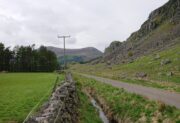
From Kirriemuir town centre up the B956 Kinnordy Road, turn left where it goes along the B955 road for several miles towards Cortachy.  Keep going on the B955 for a few more miles into Glen Clova, past the Caddam stone and eventually, after going over the bridge into Clova village, you turn left and go up towards the mountains.  Nearly 3 miles along you see the very conspicuous and impressive rising crag, like a small volcano on the right-hand side of the road, which is Dun Mor.  Walk up the steep climb round to the back of it – and you’re in the middle of the old ruins…

Archaeology & History

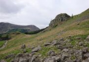
Highlighted on the 1865 OS map of the region, Dun Mor is Gaelic for a “large or great fort” – and such it is!  Those of you with a nose for these sorts o’ things will no doubt take to the remains pretty quickly.  Its position in the landscape is a bit of a gem!  On its north-side— invisible to anyone in the glen below—an overgrown arc of walling some 3 feet high and about 70 yards long bends towards the crag of rocks on each side, with a notable “dip” or entrance about 8 feet wide in the middle of it.  The walling itself averages about 4 yards wide all along its arc.

The crag of Dun Mor

It’s quite impressive once you get a good feel of the place and envisage it as it once was.  The sheltered fortress within the rise of Nature’s crags is about 100 yards across and would be ample space for several families to live in when it was first built, in those mythic times of so so long ago.  It was probably constructed in the Iron Age, although several ruined rectangular stone structures inside it are thought to be mediaeval shelters; and even in those more recent times, the people here would have regularly heard the howl of the wolves, whose names are kept in the hills above as reminders of a world not too long past….

© Paul BennettThe Northern Antiquarian

Burnt House Well, Tunbridge Wells, Kent

Healing Well (covered):  OS Grid Reference – TQ 6000 3963

Archaeology & History

Shown on early OS maps as a chalybeate spring, the denuded remains of this site can still be seen in Dunorlan Park, between the tearoom and the lake, where the spring can be seen on the left beneath a large tree.  It was first described in John Britton’s (1832) famous account of the area, who told us:

Site shown on 1872 map

“There is a spring, called Burnt House Spring, situated in a little dell, in a romantic spot to the right of the road leading from Tunbridge Wells to Pembury. It is a good chalybeate, and the iron is in a state of carbonate. This spring rises rapidly into a stone basin, placed in the centre of a circular excavation, about ten feet in diameter and six or eight feet deep, which is bricked round, and with the remains of stone steps leading down to the basin at the bottom. This spring, therefore, has clearly been, at some time, made use of as a medicinal water. It was accidentally discovered choked up with rubbish. The country about Tunbridge Wells abounds with springs of this character.”

The spring was cleaned up some time ago and its waters rise in a square stone-lined chamber—accessed by four stone steps—into a circular stone basin, before flowing down a short channel and into the drains.  I’ve no idea whether or not the water is still drinkable.

References:

  1. Britton, John, Descriptive Sketches of Tunbridge Wells and Calverley Estate, Longman: London 1832.

© Paul BennettThe Northern Antiquarian