Arncliffe, Littondale, North Yorkshire

‘Carved Stone’:  OS Grid Reference – SD 93 72

Archaeology & History

The Arncliffe Carving

The Arncliffe Carving

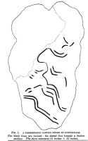
This is a frustrating site entry.  Not only do we not know where it is, this carving is not listed in any of the modern books on British petroglyphs, yet it was described and referenced by the famous archaeologist Jacquetta Hawkes following its discovery more than 80 years ago.  After a brief mention of the carving in Frank Elgee’s (1933) Archaeology of Yorkshire, an article describing the carving was penned in the journal Man, from which I draw the only information available. It appears to have been found in the early 1930s (no date or discoverer is cited), but has a couple of peculiarities which may bring the authenticity of the stone into question.  Mrs Hawkes (1934) told that the carved stone was,

“found in the bed of a moorland beck in the village of Arncliffe, Littondale, West Riding of Yorkshire.  It is of buff-coloured limestone measuring 21 inches x 12 inches x 6 inches in thickness; the decorated surface is almost flat.  The curvilinear pattern is executed in regular incisions about 4mm wide and 3mm deep; portions of it have been obliterated by water actions and, as is illustrated in the illustration, at one end the surface has broken away altogether.  The whole stone has been much battered and may well be only a fragment of a much larger one.  The state of preservation suggested that it had been in the stream for a considerable period; it is therefore probable that it was washed down from the open moorland above Arncliffe.  In the original (carving), the design is more coherent than it here appears owing to the fact that in the water-worn portions faint lines are visible to the eye which cannot be shown on a tracing.

“Mr W.J. Hemp, who has kindly examined the Arncliffe tracing, identifies the style of the design with the ‘entrail’ pattern of the well-known Pattern Stone from the chambered cairn of Bryn Celli Ddu in Anglesey…

“The technique of the Arncliffe tracing is comparable with the simple incisions which form the oldest of the four techniques recognizable in the Irish megalithic tumuli, where its early date is indicated by the fact that some examples are demonstrably older than the construction of the tumuli in which they occur…

“Mr Frank Elgee, who has also been good enough to comment on the Arncliffe tracing, cannot suggest immediate comparisons from this neighbouring group (around Ilkley, PB), but such evidence as there is he considers to be against assigning a date earlier than the MIddle Bronze Age.”

The late great Eric Cowling also mentioned the stone in his prehistoric survey of the mid-Pennines, but added no further details of his own and seems to have just copied what we have just read.

The fact that the ‘carving’ was found in a stream-bed may mean that the markings on the stone were due to natural erosion; and the fact that the rock was limestone may give added weight to this idea.  However, the fact that Mrs Hawkes, Frank Elgee and W.J. Hemp thought the carving to be authentic cannot be overlooked.  The area is also rich in prehistoric remains (see Douky BottomDewbottoms, Yockenthwaite, Blue Scar, etc)  The design itself is an odd one and has none of the traditional hallmarks consistent with neolithic and Bronze Age cup-and-ring stones, but seems more reminiscent of much earlier mesolithic and palaeolithic images of carved animals and dancing human figures.

If anyone knows more about this site, particularly its whereabouts (perhaps in private possession or hiding in some museum box, where increasing numbers of cup-and-rings are wrongfully kept), or whether the ‘carving’ has been disregarded as little more than natural weathering, it would be good to know for certain.

References:

  1. Cowling, E.T., Rombald’s Way: A Prehistory of Mid-Wharfedale, William Walker: Otley 1946.
  2. Elgee, Frank & Harriet, The Archaeology of Yorkshire, Methuen: London 1933.
  3. Hawkes, Jacquetta, “A Prehistoric Carved Stone in Littondale,” in Man, volume 34, 1934.

© Paul BennettThe Northern Antiquarian


Giants’ Graves, Halton Gill, North Yorkshire

Cairns:  OS Grid Reference – SD 856 733

Also known as:

  • Giant’s Grave

Getting Here

Easy enough to get to – and a lovely place to behold for an amble!  From Settle, take the B6479 road up to Horton-in-Ribblesdale (ask a local if you’re too dumb to find it!), turning right at Stainforth and up the single-track road towards Pen-y-Ghent.  Keep yer eyes peeled for Rainscar – you’ve about a mile to go.  If you end up at Pen-y-Ghent House you’ve gone past ’em.  Turn back for 2-300 yards.  It’s on the right-hand side of the road as you’re coming up, about 100 yards up the footpath.

Archaeology & History

The Giants' Grave plan
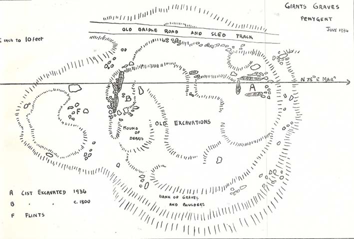
The Giants’ Graves (after W. Bennett, YAJ 1937)

The earliest description I’ve found of this is in Terence Dunham Whitaker’s History and Antiquities of Craven (1878), where he reckoned the remains here to be of Danish origin.  The same thing was professed by the southerner, archdeacon W. Boyd, who said as such to the local people hereabouts more than 100 years ago, but they thought him a bit stupid and laughed at his notions! (though it does seem that Boyd wasn’t liked locally, tending to think himself better than the local people, who told him very little of local lore and legend)  Describing the remains, Whitaker said there were skeletons found in the tombs:

“The bodies have been inclosed in a sort of rude Kist vaen, consisting of limestone pitched on edge, within which they appear to have been artificially bedded in peat earth.”

But Harry Speight (1892) doubted this, saying that Whitaker never even visited the site!  When he went here he told us that,

“What is left at present are a few mounds of earth, the largest, which is divided into two, and lies north and south, measures about 28 feet by 25 feet. There is another apparent grave-mound on the east side of it, and again to the north is an oblong excavation or trench, 7 feet wide and nearly 30 feet long, in which several bodies or coffins may have been deposited. Several large oblong stones lay flay upon the ground beside the graves, but these were removed a few years ago and degraded to the service of gate-posts.”

The site was excavated in June 1936 by Arthur Raistrick and W. Bennett (1937) after they had been badly damaged and the stones robbed for walling and other profane building operations.  Herein were found two burial cists with fragments of human bones in each tomb.  In Bennett’s short account he told:

“The site consists of a nearly circular bank, about eight feet wide, and in parts two feet high, surrounding a much disturbed area.  Within the area are the remains of two cists and a number of hollows that certainly represent other similar structures.  The farmer tells of the removal of more than twenty large stones from these hollows, for use as gateposts, wall throughs and drain covers.*  The bank encloses an area fifty-four feet east to west…and fifty feet north to south.  At the west end there is a smaller bank, roughly in form of a circular apse, extending a further thirty feet.  Many large boulders and vast quantities of smaller stone are incorporated in the bank.

“Near the east end, with its axis bearing N75E, is a cist — three stones in position.  This was cleared to a depth of eighteen inches, and though no floor stone was present, among the sifted soil were found (i) broken bones, including parts of humourus, axis, vertebrae, ulna, ribs and cranium, all human; (ii) five teeth — two molars, one wisdom tooth, and two incisors, which appear to represent tow individuals.  Sir Arthur Keith reports that the bones submitted to his examination may represent more than one adult person, and there is also a fragment of a child’s tibia.  Most of the limb bones belong to a man of medium stature… He suggests from the condition of the bones a person of the Iron Age.  While this is possible with a secondary interment in the area, it is rather unlikely, as all the bones came from within the built cists, and not from the earthen part of the mound, where secondary burials would be expected.

“At the west end are two large stones, the side stones of cists or of a chamber.  The ground in front of them has been excavated many years ago…and partially refilled with boulders… Within the small extension on the west a trial excavation showed eighteen inches to two feet of random boulders, and beneath them, on the old sub-soil surface, two inches of fine grey sand, with two small flints — one of them a well-worked blade.  These probably pre-date the construction of the circle.

“The whole site is suggestive of a multiple cist burial mound, or even a “passage grave” type.  The obvious hollows, from which many of the larger stones have been lifted, are aligned in a parallel series, along an axis N75E, directed towards the two remaining large stones at the west, which may be part of a chamber wall and not part of a cist.”

Recent archaeological analysis has suggested these may be the remains of an old chambered cairn, although there is today far too much damage that’s been done to give us an accurate portrayal of what this originally looked like.  The Dawson Close prehistoric settlement is less than half-a-mile further up the ridge.

Folklore

The folklore here is simple: these are the graves of giants who lived in the valley of Littondale in ancient times.

References:

  1. Bennett, Walter, ‘Giants’ Graves, Penyghent,’ in Yorkshire Archaeological Journal, part 131, 1937.
  2. Boyd, W. & Shuffrey, W.A., Littondale Past and Present, Richard Jackson: Leeds 1893.
  3. Feather, Stuart & Manby, T.G., ‘Prehistoric Chambered Tombs of the Pennines,’ in YAJ 42, 1970.
  4. Speight, Harry, The Craven and North-West Yorkshire Highlands, Elliott Stock: London 1892.
  5. Whitaker, Thomas Dunham, History and Antiquities of the Deanery of Craven, Joseph Dodgson: Leeds 1878 (3rd edition).

* It might be worthwhile exploring the local gateposts and walls to see if any of these covering stones had cup-and-rings carved on them, as was traditional in many parts of Yorkshire and northern England.

© Paul Bennett, The Northern Antiquarian


Dewbottoms, Arncliffe, North Yorkshire

Settlement:  OS Grid Reference – SD 9132 6950

Getting Here

From Grassington go north up the B6160, turning left to Arncliffe, and parking up by the pub.  Take the footpath past it and onto the rocky ridge to your SW for a mile-and-half.  Dew Bottoms settlement is on the wide ridge between the two decent streams dropping back into the valley road below.  Look round!

Archaeology & History

The remains of this prehistoric settlement first seem to have been described by Arthur Raistrick and Paul Holmes. (1961)  They told that:

“the principal field is approximately 120 feet square, enclosed by a massive boulder and gravel bank, probably the foundation of a substantial stockade.  The field is now mostly bare limestone pavement.  Four smaller fields adjoin it on the north and west.  Circular huts with drystone walls still about 3 freet 6 inches high before excavation, covered by collapsed material suggesting an original height of 5 feet, are placed, two of them in the course of the field wall and two in the junction of three field walls.  The huts are about 10 feet internal diameter, the walls about 3 feet thick.  A very fine quartzite hone was the only find in the huts.  There are two rectangular stone-built enclosures, 20ft by 10ft, and 15ft by 8ft, and several small rectangular enclosures, probably buildings, with walls of boulders and turf, using one wall of a field as a common back wall.  The whole site suggests a compact family farm.”

A few years later the site was visited and later described by Miss D. Charlesworth at the annual meeting of the Archaeological Society in July 1968, and is one of several found on the hills 2-3 miles southwest of Arncliffe village. Miss Charlesworth told:

“This site also faces north and covers an area of about 330 by 280ft, much of it now bare limestone. There are eight rectangular buildings and four circular huts associated with a large enclosure about 120ft square, with five smaller enclosures adjoining it.”

References:

  1. Charlesworth, D., ‘Iron Age Settlements and Field Systems,’ in Proceedings of the Archaeological Journal, 125, 1968.
  2. Raistrick, Arthur & Holmes, Paul F., Archaeology of Malham Moor, Headley Brothers: London 1961.

© Paul BennettThe Northern Antiquarian


Blue Scar Settlement, Arncliffe, North Yorkshire

Settlement:  OS Grid Reference – SD 9319 7102

Getting Here

Pretty easy really.  From Arncliffe village, walk up the Monk’s Road footpath, heading for the rocky mass immediately south.  Once you get onto the moor edge, veer straight up to your right and keep walking till you hit the rocks.  Look around!

Archaeology & History

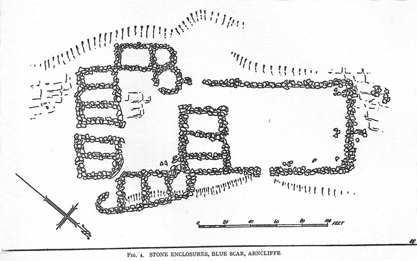
Drawing of main part of the settlement (Raistrick 1929)

Described by Miss D. Charlesworth at one of the annual meetings of the Archaeological Society in July 1968, this ‘settlement’ is found immediately south of Arncliffe village, literally 1000 feet up on the hillside and has a field system attached to it.  When Charlesworth described this place, it had not been excavated, though her description of the place very much echoed those of Raistrick & Chapman (1929) nearly forty years earlier.  She wrote:

“It faces north and east over the Skirfare valley, sheltered by the bulk of Parson’s Pulpit. The most interesting feature is the rectangular enclosure west of the sunken road. The walls are built of limestone some 5ft wide at the base and standing 2-3ft (tall). The huts are grouped round a courtyard at the south-eastern end and have a large stockyard attached to them. Of the 14 huts, only two are circular (those in the northwest corner), and one on the east side is approximately a circle. The remainder are rectangular, approximately 30 by 12ft.”

Although the sites is generally ascribed as Iron Age to Romano-British in date, it seems evident that these buildings were used in much later centuries — perhaps until late medieval periods.  Other remains of similar size and stature can be found scattered on the hills near here (I’ll add them on TNA at sometime in the future).

References:

  1. Charlesworth, D., ‘Iron Age Settlements and Field Systems,’ in Proceedings of the Archaeological Journal, 125: 1968.
  2. Raistrick, Arthur & Chapman, S.E., ‘The Lynchet Groups of Upper Wharfedale, Yorkshire,’ in Antiquity, volume 3, 1929.

© Paul Bennett, The Northern Antiquarian