Mauns Stone, New Deer, Aberdeenshire

Legendary Rock (destroyed):  OS Grid Reference – NJ 89397 49502

Also Known as:

  1. Crawey Stone
  2. Crawford Putting Stone
  3. Crawstane
  4. Devils Putting Stone

Archaeology & History

Stone shown on 1874 map

A site whose main claim to fame is its legendary nature.  Seemingly buried or destroyed around the end of the 19th century, there have been suspicions that the stone might have had cup-marks on it (see Folklore below), but we’re not sure.  Modern lore tells that when roadworks were done here in the 1950, a large stone was uncovered.  A local man who was passing by told that he’d seen the Crawey Stone in his youth and that the stone they’d uncovered was one and the same.

Folklore

The story that used to be told amongst local people was thankfully preserved in an article by the pseudonymous “Mormond” (1889) in Scottish Notes & Queries.  He told that:

“In the parish of New Deer, and in a field near the Old Castle of Fedderat, there is a large boulder of ten or twelve tons known as the Crawey Stone.  I am unable to say if it still occupies its old site, or if it has been broken up for building purposes.  The legend connected with this stone used to be well known in the parish, and a version of it appeared in The Aberdeen Magazine some 70 or 80 years ago.  This version is substantially the same as the legend known in the district, and relates how a Crawford, the lord of the castle and lands, one day “as he looked o’er his castle wa’ ” — a phrase which often occurs in old ballads — observed a crunkled carl (old woman or witch, PB) inspecting the stone and afterwards successfully lifting up one end clear of the ground.  Not to be conquered by such a shabby looking stranger, the laird, who was famed for his athletic powers, went out and challenged the carl; but on attempting to lift the boulder, burst a blood vessel; and the carl, who stood by watching him, suddenly disappeared in a flash of fire taking the remains of the laird along with her.  The tradition is that the laird was not mourned for in the district, and the moral drawn was “He couldna hae expected ony ither en’.”  When passing the boulder going to school, the legend was often referred to, and some indentations on it pointed out as the marks of the ill man’s fingers made at the time the superhuman feat was accomplished.”

These finger marks have been taken as possible cup-markings.  They might have been, but we simply don’t know; they may just have been curious natural markings that gave rise to this animistic creation myth.  Another tale told that the markings were due to an old giant in the neighbourhood who used the rock as a putting stone and rolled it to the spot where it used to stand.  Giants are always attached to indigenous creation myths, some of which go back thousands of years.

In the OS Name Book for Aberdeenshire written in the late 1860s, they told how the Maun Stone is,

“a large Stone of a roundish shape, built on an old fence, forming a side of the Public road leading from New Deer to Brocklay.  Tradition asserts that it has been the putting Stone of a Giant in ancient times.  There are Several holes in the Stone said to be the finger marks of the Giant.”

References:

  1. Mormond, A., “Legends and Rhymes Connected with Travelled Boulders“, in Scottish Notes & Queries, volume 2, 1889.

© Paul BennettThe Northern Antiquarian

Moses’ Well, Morton, Thornhill, Dumfriesshire

Holy Well:  OS Grid Reference – NX 8799 9431

Archaeology & History

Moses Well on 1861 map

This little-known Biblical-sounding spring has apparently long since fallen back to Earth (perhaps there might be some local folk who could find out for certain).  Shown on the 1861 Ordnance Survey map as being at the side of the wall in the small copse of trees—immediately east of kirk- place-names and a half-mile north of St Ninian’s Well—it was briefly described by T.C. Ramage’s (1876), who seemed to know nothing of its lore, merely telling us that,

“on Templand farm, close to the wooden bridge over the Cample, there is Moses’ Well, an unusual designation, but which some Knight Templar may have given in remembrance of his toils in Palestine.”

The Templar designation was deemed by Ramage to come from the name of the farm.  However, a few years prior to this, the early Scottish place-name surveyors were traversing the area and found from local people how it derived “its name from a Tinker named Moses Marshall who with his family lived near it in a Camp during the time they had the small pox.”  The Well was also included in the Morris survey (1982), but without comment.  Another Moses Well can be found 44½ miles to the northeast, near Galashiels at NT 4046 4306.

References:

  1. Morris, Ruth & Frank, Scottish Healing Wells, Alethea: Sandy 1982.
  2. Ramage, Craufurd T., Drumlanrig Castle and the Douglases, J. Anderson: Dumfries 1876.

© Paul BennettThe Northern Antiquarian

Kirk Stones, Morton Moor, West Yorkshire

Legendary Rocks (destroyed):  OS Grid Reference – SE 0886 4479

Archaeology & History

Kirk Stones on 1851 map

Kirk Stones on 1851 map

A place-name that is still recognised on modern Ordnance Survey maps, even though the original site giving rise to it was all but destroyed some one hundred-and-fifty years ago.  Derived from the old word kirk, meaning a church or sacred site, no christian remains of any kind have ever existed here and so we must presume an earlier, more heathen site of sanctity (an abundance of prehistoric petroglyphs exist very close by).  The singular reference detailing the nature of these Kirk Stones is in J.A. Busfield’s (1875) rare tract on the history of Upwood, in the parish of Bingley.  Upwood Hall was built by the Busfield family and, as the author tells,

“one of the most striking features in the vicinity at this age [c.1800, PB] was the fine range of magnificent rocks called Kirkstones, which had existed for countless ages. These grand rocks, towering one above another, extended along the whole southern boundary of the [Whetstone] Allotment on the left of the road to Ilkley, and were really a fine object, but alas!, through the ignorance or stupidity of the agent Colonel Bence, the “Crags of Kirkstone” were broken up and disposed of in the construction of the Bradford Water Works about the year 1854.”

Sadly we have neither illustrations nor other references to these fine sounding sentinels.
Undoubtedly the Kirkstones were a natural feature, despite their venerated title. It would have been their very appearance that gave rise to their revered title, as in the great and contorted rock masses seen at Brimham Rocks which, from Bensons’s description, these Kirk Stones seem reminiscent. The only piece of extant lore to these stones is that the uprights that went into making the recently destroyed Bradup stone circle a short distance south of here, came from this sacred outcrop.  It seems reasonable to assume that they played an important role in the magickal history of these hills when they were scattered with forest.

The Kirk Stones aligned along the equinox axis to the Black Knoll standing stone less than a mile [1.4km] due east.

References:

  1. Bennett, Paul, The Old Stones of Elmet, Capall Bann: Milverton 2001.
  2. Busfield, Johnson Atkinson, Fragments Relating to a History of Bingley Parish, Bradford 1875.
  3. Smith, A.H., English Place-Name Elements – Part 2, Cambridge University Press 1956.

© Paul BennettThe Northern Antiquarian


Fairies Chest, Embsay Moor, North Yorkshire

Legendary Rocks:  OS Grid Reference – SD 98696 56105

Also known as:

  1. Fairy’s Chest

Getting Here

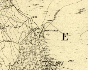
Fairies Chest on 1853 map

This is an awesome beast! You can either approach it from Nettlehole Ridge ‘stone circle’ as I did, or take the more sensible approach and begin from Embsay village, walking up the path towards Embsay reservoir and onto the moorland heights of Crookrise Crag, 1350 feet above sea level. Worra view! But keep walking a little more, downhill, and it’ll hit you right in the face!

Archaeology & History

Fairy’s Chest, Embsay Moor

Known as an abode of the little people in the 19th century and shown on the earliest Ordnance Survey map of the region, I know of no previous accounts of this giant elongated boulder, forty feet long and nearly the same size as our legendary Hitching Stone that’s nestled below the small cliffs.  The boulder is surrounded by what seems like cairn-material on all sides (though it doesn’t look prehistoric). You’re looking straight west from here, right at the three small paps of Sharp Haw, Rough Haw and Flasby Fell.  If you like huge rocky outcrops, this (and others nearby) will make your day!

Folklore

Said to have been the abode of the little people in ages gone by; though even an old chap we met on our wander here told us how the legends it once held “have died with the old folk it seems.”

© Paul Bennett, The Northern Antiquarian