Ruston Beacon, Ruston Parva, East Yorkshire

Tumulus (destroyed):  OS Grid Reference – TA 0584 6128

Archaeology & History

Ruston Beacon tumulus on 1854 map

Ruston Beacon tumulus on 1854 map

A fallen tumulus that once marked the southwestern side of the village boundary line, and was once adjacent to the prehistoric Green Dikes earthworks that once passed here.  Sadly however, sometime early in the 20th century, this ancient burial mound fell victim to usual ignorance of arrogant land-owners who place money ahead of history and local tradition and it was ploughed-up and destroyed.  Thankfully we have an account of the site in J.R. Mortimer’s (1905) incredible magnum opus.  Listing it as ‘Barrow no.272’ in the number of tombs excavated, he told us that:

“It is situated on elevated ground about half-a-mile (south)west of Ruston Parva.  On September 20th and 21st, 1886, it measured about 70 feet in diameter and 2 feet in elevation; and had originally been several feet higher, as an old inhabitant remembered assisted in removing its upper portion, which was carried away and spread on the surrounding land many years previously.  At the base of the barrow, near the centre, was a long heap of cremated bones which had been interred in a hollow log of wood with rounded ends, about 3 feet in length and 14 inches in width, well shown by impressions in the plastic soil, and by the remains of the decayed wood.  The heap of bones was rather large and probably consisted of the remains of more than one body.  No relic accompanied them.  Several splinters and flakes of flint were picked from the mound.”

The tumulus (as its name implies) became a spot besides which one of East Yorkshire’s many ancient beacons were built.  In Nicholson’s (1887) survey of such monuments, he told that

“the modern beacon, apparently, stood on the site of the old one, on the high ground in the angle of the road from Driffield to Kilham.  It was a prominent object and would be well-known to the coachmen and guards…for it stood on the side of the road from Driffield to Bridlington.  Mr John Browne, of Bridlington, remembers it; and says, ‘It would be the last of the beacons that remained in this district and was removed between fifty and sixty years ago.  My recollection of it is that it was a tall pole, with a tar barrel at the top, and had projected steppings to reach the barrel.”

One of the earliest accounts of the beacon from the late-1500s told that it took signal for its light from the beacon at Rudston, which stood upon one of the Rudston cursus monuments, a short distance from the massive Rudston monolith.

References:

  1. Mortimer, J.R., Forty Years Researches in British and Saxon Burial Mounds of East Yorkshire, Brown & Sons: Hull 1905.
  2. Nicholson, John, Beacons of East Yorkshire, A. Brown & Sons: Hull 1887.

© Paul Bennett, The Northern Antiquarian


Rudston B Cursus, East Yorkshire

Cursus:  OS Grid Reference – TA 0805 6697 to TA 0944 6755 

  1. Rudston Cursus 2

Archaeology & History

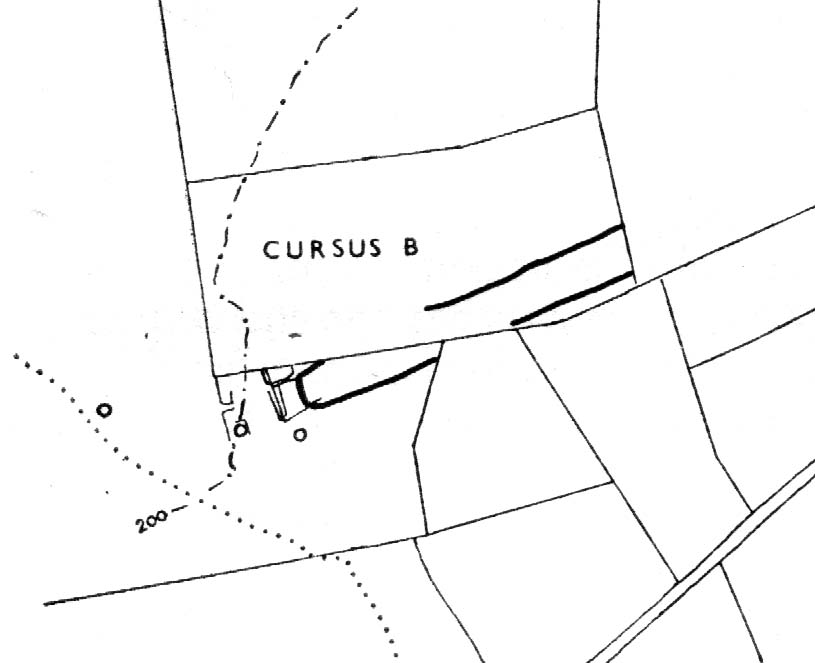
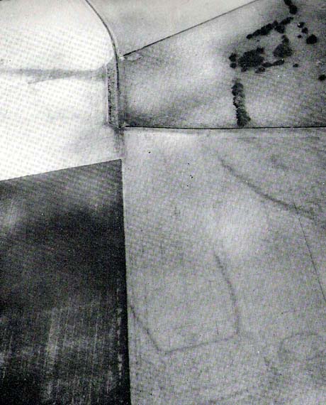
One of the four (known) cursus monuments around Rudston: this one stretches between the Ordnance Survey coordinates TA 081669 near Kilham Grange on the southwestern edge of Rudston, then heads northeast towards the village itself at TA 094675.  Described briefly in D.P.Dymond’s essay on (mainly) Cursus A, he said how Cursus B was part of,

Early ground-plan (after D.P. Dymond)
Early photo of Rudston B (after J.K.St Joseph)

“a large complex of crop marks.  The largest feature is the squared, tapering end of Cursus B, which can be traced for 700 yards in a north-easterly direction.  No surface remains seem to survive in an area intensively ploughed, except for a swelling under a hedge on the line of the south-eastern bank (at TA 0834 6703).  West of the square end and partly overlying it, are several small rectangular enclosures, which are probably part of a later (?Romano-British) settlement and field-system.  Also in this tangle of crop-marks there are four roughly circular shapes, which may well be barrow circles associated with the end of the cursus.  On certain barrow just south of the end of the cursus has an inner ring of pits.  Where the cursus is lat visible to the north-east, it is headed roughly for the monolith ¾-mile away.  The width of Cursus B is approximately 90 yards between ditch centres.  It has its square end on the forward slope of a ridge (like Cursus A) at a height of 180 feet OD, and descends towards the village, which is visible from the end, through a shallow valley.”

Dymond’s note about the alignment feature of this cursus, towards the gigantic Rudston monolith, was one echoed in the Hedges & Buckley (1981) survey.  They noted:

“At Rudston, the B cursus extended eastwards aligns upon the Rudston monolith in Rudston churchyard. Destruction of standing stones elsewhere may have removed similar associations between the stones and cursuses.”

This alignment feature was also confirmed by cognitive archaeologist and alignment specialist, Paul Devereux (Pennick & Devereux 1989) in his survey of cursus monuments.

Typical of these fascinating antiquities, nothing of any worth has been found along the length of the cursus that can give us any clues to its nature and function.  However, the presence of this and three others close by indicates that the region was an exceptionally important one in the cosmology of our prehistoric ancestors.  Four of these giant linear cursus monuments occur in relative proximity, and there was an excess of ancient tombs and, of course, we have the largest standing stone in the British Isles stood in the middle of it all.  A full multidisciplinary analysis of the antiquities in this region is long overdue.  To our ancestors, the mythic terrain and emergent monuments hereby related to each other symbiotically, as both primary aspects (natural) and epiphenomena (man-made) of terra mater: a phenomenon long known to comparative religious students and anthropologists exploring the animistic natural relationship of landscape, tribal groups and monuments.

References:

  1. Dymond, D.P., “Ritual Monuments at Rudston, E. Yorkshire, England,” in Proceedings of the Prehistoric Society, volume 32, 1966.
  2. Eliade, Mircea, The Sacred and the Profane, Harvest: New York 1959.
  3. Hedges, John & Buckley, David G., The Springfield Cursus and the Cursus Problem, Essex County Council 1981.
  4. Pennick, Nigel & Devereux, Paul, Lines on the Landscape, Hale: London 1989.

Links:

  1. ADS: Archaeology of Rudston B – Brief archaeological notes on the cursus to the southwest of Rudston.

© Paul Bennett, The Northern Antiquarian