Burnt House Well, Tunbridge Wells, Kent

Healing Well (covered):  OS Grid Reference – TQ 6000 3963

Archaeology & History

Shown on early OS maps as a chalybeate spring, the denuded remains of this site can still be seen in Dunorlan Park, between the tearoom and the lake, where the spring can be seen on the left beneath a large tree.  It was first described in John Britton’s (1832) famous account of the area, who told us:

Site shown on 1872 map

“There is a spring, called Burnt House Spring, situated in a little dell, in a romantic spot to the right of the road leading from Tunbridge Wells to Pembury. It is a good chalybeate, and the iron is in a state of carbonate. This spring rises rapidly into a stone basin, placed in the centre of a circular excavation, about ten feet in diameter and six or eight feet deep, which is bricked round, and with the remains of stone steps leading down to the basin at the bottom. This spring, therefore, has clearly been, at some time, made use of as a medicinal water. It was accidentally discovered choked up with rubbish. The country about Tunbridge Wells abounds with springs of this character.”

The spring was cleaned up some time ago and its waters rise in a square stone-lined chamber—accessed by four stone steps—into a circular stone basin, before flowing down a short channel and into the drains.  I’ve no idea whether or not the water is still drinkable.

References:

  1. Britton, John, Descriptive Sketches of Tunbridge Wells and Calverley Estate, Longman: London 1832.

© Paul BennettThe Northern Antiquarian

Power Station Road, Sheerness, Isle of Sheppey, Kent

Settlement (destroyed):  OS Grid Reference – TQ 932 733

Archaeology & History

An extensive site that was uncovered when a housing estate was being built on the south-side of Power Station Road at the end of the 20th century.  During the Spring and Summer of 1998, the Canterbury Archaeological Trust began cutting trenches across the land and did some minor excavation work on the west side of the area, finding some traces of early human activity.

A second series of investigations was then undertaken by the Hertfordshire Archaeological Trust  over the Autumn and Winter months of 1998-99, with the Kent Archaeological Rescue Unit then taking over for the rest of the year.  Their team split the land into eight large sections and began a more detailed analysis and uncovered a huge number of finds.  Amidst this, wrote Brian Philp (2002), there

“included an important collection of Bronze Age material, including large clay-weights, perforated baked-clay slabs and a good range of pottery types.  Of special interest was the spinal bone of a large whale, perhaps washed up on the nearby shore.

“The picture now emerging is that of a substantial Bronze Age settlement site, spread across several acres and probably farming the adjacent land… It seems likely that three large ponds and…eight stone-lined pits were primarily for water-storage, both for watering cattle and for other agricultural or semi-industrial purposes… All this seemed to be happening about 900-400 BC on what still appears to be the largest Bronze Age settlement so far discovered on this important island.”

The archaeocentric place-name of Barrows Hill rises a mile to the southwest.

References:

  1. Philp, Brian, Archaeology in the Front Line, KARU: Dover 2002.
  2. Schuster, Jorn, “The Neolithic to Post-Medieval Archaeology of Kingsborough, Eastchurch, Isle of Sheppey: From Monuments to Fields,” in Archaeologia Cantiana, volume 130, 2010.

Links:

  1. Kent Archaeological Review

© Paul BennettThe Northern Antiquarian 2016


Haly Garden Spring, Burham, Kent

Holy Well:  OS Grid Reference – TQ 731 614

Also known as:

  1. Pilgrim Spring (possibly?)

Getting Here

To find the Pilgrim Spring, the probable site see below, take the road to Blue Bell Hill out of Aylesford and after passing a footpath sign and red house, you will soon come across a farm road. (not signposted with a white gate). Drive or walk up here and the spring heads will be obvious, one beside the drive, one below the derelict farm buildings and a large one above them further along the footpath. An alternative route is via the Coffin Stone off the Burham road past Kits Coty.

Archaeology & History

The location of the Haly Well of Haley Garden, has caused a fair amount of confusion from Kent historians being some discussion has occurred regarding its exact location, although Hale Farm may have taken its name from it. Harris (1719) in his work on Kent Topography notes that a well, that had many virtues, in particular cleansing sin:

“Under Boreham (Burham, Burgham) formerly there was a fountain in this Parish (South Philipot) at a place called Haly or Holy Garden, which was accounted mighty sacred by common people, and had very uncommon virtues ascribed to it, and in the 17th year of King Richard II, The Friars Carmelites of Aylesford obtained a grant by letters Pateill to bring the water from to their monastery.”

Hunter (1811) refers to the friars building an aqueduct from the site.  Finch (1925) believes that the well lay eleven hundred yards due west of the Kewland Wheel Well house. Although, he also states that other authorities believed that this wheel well itself was the site. This belief was discredited, however, when its well shaft was explored: no chambers or tunnels were found to lead off of from it. Sadly, there is no evidence of Great Kewland house, although some house debris down a nearby wooded quarry can be located, although being tightly fenced in, one is unable to find any remains of a well or local knowledge.

Folklore

The possible location for the spring is Pilgrim’s Spring, (TQ 731 614) in the old community of Tottington. Finch (1925) in his a Tramp in Kentish Pilgrim Land describes a pool surrounded by sarsens believed to be of ancient origin:

“Spread around this beautiful spring head in plenteous disorder is a large number of huge stones, some thrown into the bed of the stream, others supporting its margins. Some half buried and peep through the ground. With Cromlech and altar thrown down and heaped around the spring, it is left to our imagination to picture this site of ancient water worship in the dim and distant past. The stone circle appears to have completely encircled the principal spring; hence there are reasonable grounds for concluding that too was devoted to water worship.”

Of course, the description is perhaps tainted by the ‘Druid’ obsession of Victorian antiquarians, so perhaps the stones are natural, although close to recognised ancient monuments. This spring would appear to be a likely watering hole for those visiting the nearby lost shrine of St. Stephen and maybe Halygarden Springs as the stream does travel towards Aylesford. Finch (1925) notes that five springs fed the moat that surrounded the ancient manor, and were according to Dr. Thorpe (1788) quoted by Finch, of petrifying quality so that sticks become encrusted in it. Today one can still trace both the manor and moat despite its dereliction. The springs still exist too, but the number of sarsens associated with them appears to have been reduced, and one would suggest that a number have been dragged from their position and placed on the Coffin Stone.

Another possible site is  a Roman or Ancient Draw Well, (TQ 741 809) According to Finch (1925), there is a legend connecting the well with another that of Kewland by a secret tunnel. Finch (1925) notes that there is:

“…an elm tree and some stones of various sizes, beneath which is a well only some two feet in diameter, but tested to be 113 feet deep. This doubtlessly was sunk for a water supply for the Roman occupants hereabouts.”

Finch (1925) expected that this well was a local myth but was fortunate to find a sixty year old man, who as a boy, used to drop flints down it. He notes that:

“The elm tree is bowed over with age and its sinuous roots have all but closed the entrance to the well, leaving but a tiny aperture through which one could see the rough coping stones. With a little dexterity, one could drop a stone, time its fall, and hear the thus as it fell upon the accumulated debris on the bottom no casual visitor could find the well, even though accurately marked upon a plan, without a guide.”

Certainly, it is unmarked on the present maps, and attempting to uncover its location I was hindered by considerable ivy cover and rubbish. I did locate a large amount of brick and stone debris at one site and possibly remains of a dead elm, but conclusively.

(taken from the forthcoming Holy Wells and Healing Springs of Kent)

Links:  http://www.insearchofholyandhealingwells.wordpress.com

© R.B. Parish, The Northern Antiquarian and Pixyledpublications


Dumpton Park, Ramsgate, Kent

Tumulus (destroyed):  OS Grid Reference – TR 389 661

Archaeology & History

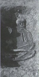
A little-known site which archaeologist Brian Philp (2002) called “a Bronze Age barrow”.  When the old Greyhound Stadium at Ramsgate was being demolished for a new housing estate, planning conditions required an archaeological evaluation and so Philps and his team set out to explore the area in February 2000.  They weren’t to be disappointed!  Unearthing a ring ditch nearly 20 yards (18m) across, they found that it had been cut into the local chalk some three feet deep.  Although there was no obvious entrance, the northeast section of the ancient monument,

“was found to be covered by a compact layer of flint metalling.  This was a wide and well-made surface or platform, perhaps of Iron Age date, which clearly covered the silted ring-ditch,  Nearby was a large male skeleton in a very shallow grave and with head missing due to later disturbances.”

The excavated ring ditch (after Philp 2002)

The excavated ring ditch (after Philp 2002)

The crouched skeleton (after Philp 2002)

The crouched skeleton (after Philp 2002)

But the best was yet to come!  In another section of the circular monument, cut into the chalk itself, they found a complete male skeleton laid in typical foetus position, on its left side, with a large beaker pot positioned in front of it.  These beakers are pretty common and tend to be seen as once holding food enabling the dead to eat in their journey into the Land of the Dead.  It makes sense.  The entire monument has since been completely destroyed.

References:

  1. Philp, Brian, Archaeology in the Front Line, KARU: Dover 2002.

Links:

  1. Kent Archaeological Review

© Paul BennettThe Northern Antiquarian 2016


Black Prince’s Well, Harbledown, Kent

Holy Well: OS Grid Reference – TR 129 582

Also known as:

  1. Leper Well
  2. St. Thomas’s Well

Getting Here

The Black Prince’s Well is found to the right of a path that curves around past the Leper Hospital / almshouses, and through the forecourt of a house.

Archaeology & History

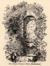
Black Princes Well

Black Princes Well

Behind the old leper hospital, and to the west of the Church, is the Black Prince’s Well, a holy well of some renown and interest. For Canterbury pilgrims, the well was a significant watering hole before they made the last steps to that great Shrine of St. Thomas. According to Watt (1917) this was the seventh St. Thomas’s Watering at Harbledown. It still bears the alternative name of St. Thomas’s Well, a dedication unlike other sites would seem to be related to be a direct relationship, for it is recorded that he drunk from the well, accidentally leaving a shoe. Understandably, after the martyrdom, this became an important relic, and was held by the Hospital.

The spring emerges at the foot of the hill, enclosed in a six foot high semicircular domed well head made from rag stone. Most interesting a carved stone, in its central apse, depicts the Black Prince’s coat of arms, three feathers taken from the King of Bohemia at Crecy. This stone appears to havebeen possibly derived from another structure rather than being carved especially for the well head, as do the fluted stones shown in earlier photos (cf Goodsall (1968) in his Kentish Patchwork), which are now apparently missing. Either side of the well head are two courses of rag stone walling. The well is reached by a series of stone steps between two courses of stone walling. The water emerges, as a small trickle, through a five inch diameter red clay pipe, flowing to fill a circular basin.

Folklore

The well was noted as being able to cure leprous ailments, and presumably this is why the leper hospital was built in 1084 by Archbishop Lanfranc to exploit its properties. Among its many early pilgrims looking for a cure for this complaint was Edward the Black Prince, who patronised the well twice: the first on his last journey to Canterbury, when he was cured, and then finally, on his death bed in 1376. Unfortunately in this latter case the waters were obviously of no use, being unable to rid him of his syphilis, of which he died. The well subsequently named after the knight. For those unable to drink straight from the well, water was often administered to those living far from it. Evidence for this being the discovery of a leather pouch found near the well. Indeed, even the early part of this century the water was still used, especially by those from afar, for Snowdon Ward (1904) remarks that:

“the water is still in some repute for its curative powers. The sub-prior of the hospital told us that he still occasionally receives small remittances from various parts of the continent…”

Cartwright (1911) illustrates that its local reputation was still current before the Great War. He records that it was:

‘still believed by Country folks to be of great benefit to the eyes.’

Certainly the well is one of the most interesting and enchanting of Kent wells.

(taken from the forthcoming Holy Wells and Healing Springs of Kent)

Links:  http://www.insearchofholyandhealingwells.wordpress.com

© R.B. Parish, The Northern Antiquarian and Pixyledpublications


Baston Manor, Hayes, Kent

Settlement:  OS Grid Reference – TQ 407 649

Archaeology & History

This settlement site was found thanks to the good work of the Bromley & West Kent Archaeology Group in the 1960s, when they decided to do follow-up work to what Brian Philp (2002) described as “doubtful sites reported mainly in the 19th century.”  Time and again these “doubtful sites” at least turn into something of value — and such was the case here!  The group commenced digging selective trenches in July 1964 in a small wooded area near to Baston Manor and they soon came across “a stratified deposit of late-Neolithic (2500 BC) pottery and flint.”

In successive returns to the site over two years, 5630 items—primarily fire-cracked stones, flints and more than 200 pieces of pottery, some of which was highly decorative—were unearthed and the site was recognised as an important settlement arena many thousands of years ago.  In Kent, this was a rarity!  Philps’ resumé of the site and its many remains told,

“Sometime about 2500 BC, a group of late-Stone Age farmers had selected this quiet hillside (now just in Hayes) to settle and live.  Here they must have farmed  small cultivated areas close to their huts and herded sheep and cattle to fresh areas and nearby streams.  These were the first occupants of the West Wickham valley over 4000 years ago…”

References:

  1. Philp, Brian, “The Discovery of a Secondary Neolithic Site at Hayes,” in Kent Archaeological Review, no.5, 1966.
  2. Philp, Brian, Archaeology in the Front Line, KARU: Dover 2002.
  3. Smith, Isobel, “Prehistoric Pottery from Baston Manor, Hayes,” in Kent Archaeological Review, no.18, 1969.

Links:

  1. Kent Archaeological Review

© Paul BennettThe Northern Antiquarian