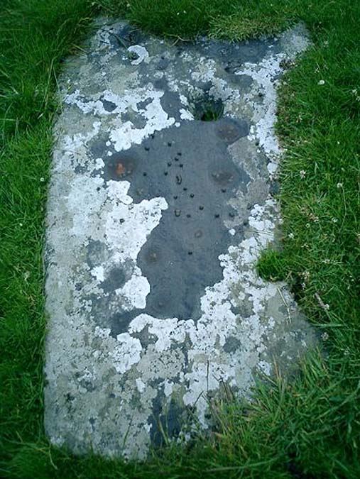
Kilchiaran, Islay, Argyll

Cup-Marked Stone:  OS Grid Reference – NR 2043 6010

Also Known as:

  1. Canmore ID 37470
  2. Cill Chiarain

Archaeology & History

An unusual cup-marked stone — not because it’s found in the grounds of the chapel, but because the design appears carved on a flat slab, as if it might have been used as a grave cover or perhaps stood upright in times gone by.  First described in Rob Graham’s Carved Stones (1895) in the days when a few more cup-markings were visible; nearly a hundred years on it was included in the Royal Commission’s (1984) report as “a prone slab measuring 1.7m by 0.98m and 0.15m in greatest thickness; its upper surface bears at least nineteen plain cups up to 110cm in diameter and 40mm in depth.  In addition, wear has caused a large deep cup, 180mm in diameter and 80mm deep, to penetrate the stone, and there is another circular, vertical-sided, perforation measuring 70mm in average diameter and expanding to 90mm at the upper surface on the stone” — meaning there’s a hole that’s been worn through the rock itself.  This hole would seem to be accounted for by the folklore tradition of the site.

Folklore

It was reported by R.W.B. Morris (1969) that the cups here were “said to have been enlarged by a former ‘wishing’ rite” — a tradition echoed at another carving not far away where a pestle was used on the cup-marks and rotated 3 times, then a wish was made and an offering left to aid the wish.  Morris suggests this could have been a faint relic of solar worship.

References:

  1. Graham, Robert C., The Carved Stones of Islay, James Maclehose & Son: Glasgow 1895.
  2. Morris, Ronald W.B., “The cup-and-ring marks and similar sculptures of Scotland: a survey of the southern Counties – part 2,” in Proceedings of the Society of Antiquaries, Scotland, volume 100, 1969.
  3. Royal Commission on Ancient & Historical Monuments of Scotland, Argyll: volume 5 – Islay, Jura, Colonsay and Oronsay, HMSO: Edinburgh 1984.

Acknowledgements:

With huge thanks to Stuart Holdsworth for use of his photo!

© Paul Bennett, The Northern Antiquarian


Achnancarranan, Islay, Argyll

Standing Stones:  OS Grid Reference – NR 3895 4606

Also Known as:

  1. Canmore ID 37581

Getting Here

From Port Ellen take the A846 road east to Laphroaig, and on the far side of the village, past the small forested part on your left, walk up the slightly sloping hill alongside the small River Kilbride.  Over a couple of walls on your way up, look up the small hill to your right (north) and you’ll see these large standing stones.

Archaeology & History

A triple-stone row no less!  Although only two of these stones are upright, a third central prostrate stone is included in archaeological surveys as an original upright.  And it seems likely. Although passed over in Alexander Thom’s astroarchaeological analyses, Clive Ruggles (1984) looked at this stone row and found the alignment here to possess no solar or lunar function.  But if it aligns north the mythic relationship obviously relates to death, as North “is the place of greatest symbolic darkness” where neither sun nor moon ever rise nor set.   There may have been an early association with Alpha Draconis, or Thuban in the constellation of the Dragon: the Pole Star in early neolithic times around which the heavens were seen to revolve by our ancestors and hold the pillar of the sky in place.  But we may never know.  Perhaps by the time these monoliths were erected, the mythos relating to A.Draconis may have faded…

The stones are found amidst a scatter of other neolithic and Bronze Age remains.  In the Royal Commission (1984) report on the stones they described the respective monoliths as follows:

“The north stone, measuring 1.28m by 0.35m at the base and 2.70m in height, rises with a gradual taper, the top curving gently to its highest point at the top of the south side.  The centre stone, now prone, has fallen onto its E face and lies embedded in the ground with its upper surface (originally the west face) flush with turf; it is 3m long and up to 0.9m broad.  The south stone measures 0.80m by 0.40m at the foot and 2.85m in height.  It leans towards the west and the top slopes down sharply from the south to a shoulder 2.1m above ground level on the north side.”

…to be continued…

References:

  1. Burl, Aubrey, From Carnac to Callanish, Yale University Press 1993.
  2. Royal Commission on the Ancient & Historical Monuments of Scotland, Argyll – volume 5: Islay, Jura, Colonsay and Oronsay, HMSO: Edinburgh 1984.
  3. Ruggles, C.L.N., Megalithic Astronomy: A New Archaeological and Statistical Study of 300 Western Scottish Sites, BAR: Oxford 1984.

© Paul Bennett, The Northern Antiquarian


Cultoon, Portnahaven, Islay, Argyll

Stone Circle:  OS Grid Reference – NR 1956 5697

Also Known as:

  1. Cultoun

Archaeology & History

Following excavation work on this denuded megalithic ring in 1974 and 1975 under the joint auspices of the Islay Historical Works Group (IHWG) and the Hunterian Museum of the University of Glasgow, under the direction of archaeologist Dr Euan MacKie (1976), with the intent of actually restoring the site to what they thought was its former glory by resurrecting the fallen monoliths in this ring of stones, some intriguing facts came to light.  Dr MacKie wrote:

“This site stands on a low, shallow knoll about a mile from the sea and with an extensive peat bog to the west.  Before excavation the stone ring consisted of a rough oval of two standing stones and ten fallen ones, the latter being partly or nearly completely buried under the turf.  The dimensions of the ring were about 45 by 40 yards.  The excavations were based on a 6m grid and the ain was to explore as much as possible the perimeter of the ring and part of the interior.  In this way it was hoped to identify the sockets from which the prone monoliths were assumed to have fallen and thus to discover the exact positions at which they were to be re-erected…

“It soon became clear that the prone monoliths had not in fact fallen out of their sockets.  All of them lay on the old ground surface under the peat which had evidently begun to grow — in the 8th century BC according to one C-14 date — after the site had reached its present condition.  Some stones had no socket next to them and a number of sockets were found without adjacent stones.  Several stones lay next to sockets in such a position as to make it clear that they had never been set up.  The site had evidently been abandoned in the middle of construction and those sockets already dug were allowed to fill slowly with rubble and silt.  One socket was discovered which had been deliberately filled up, confirming that some change of plan had occurred before the final abandonment.  Cultoon is the only stone circle apart from two phases of Stonehenge to have revealed evidence of never having been completed. (my italics, Megalithix)

“The finds were few and consisted of mesolithic flint microliths and some larger, presumably neolithic flints.  The former were all on and in the buried topsoil — the circle builders’ ground surface — while the latter were on the land surface and in the lower part of the peat; these last included scrapers and are hollow-based points of Bronze Age type.  Of particular interest was the discovery of caches of flint flakes in the peat next to the two standing stones.  They appear to be deliberate offerings and suggest that the site retained its sanctity for some centuries after its abandonment.”

…to be continued…

References:

  1. MacKie, Euan, “Cultoon, Islay,” in Glasgow Archaeological Society Bulletin, No.2, 1976.

© Paul Bennett, The Northern Antiquarian


Ardtalla, Islay, Argyll

Standing Stone:  OS Grid Reference – NR 4657 5456

Also Known as:

  1. Canmore ID 38056

Getting Here

Takes a bitta getting to this one, right at the far end of the road, leading to nowhere – so those of us who like Scotland for its vast expanses of ‘middle o’ nowhere’ should like it! From Port Ellen, travel along the A846 eastwards, all the way to the where it ends in Ardbeg. But the smaller track road continues up the coast. Keep going – and keep going all the way up; past the ‘stone circle’ of Ardilistry, past the standing stone of Trudernish, right to the very end where the track leads you to the farmhouse of Ardtalla. Once here, you’ll see the stone about 20 yards west of the farm.

Archaeology & History

This old stone is only 4-foot-tall, leaning slightly, but—as I recall from many years back—”it’s cute!” (sad aren’t I?!)  All the way up here to see a small monolith!  Even the Royal Commission (1984) lads didn’t have much to say about it, merely:

“This standing stone is situated 18m NW of the SW gable of Ardtalla farmhouse.  Leaning slightly to the SSE, it measures 0.48m by 0.48m at the base and 1.25m in height.”

But if you like walking, the rest of the route up the coast is excellent. Stick yer tent in the small woodland by the fort a mile or two further north, then bring your attention to the legendary Beinn na Cailleach, if the heathen within you stirs…

References:

  1. Royal Commission on the Ancient & Historical Monuments of Scotland, Argyll – volume 5: Islay, Jura, Colonsay and Oronsay, HMSO: Edinburgh 1984.

© Paul Bennett, The Northern Antiquarian


Neriby, Bridgend, Islay

Standing Stone (destroyed):  OS Grid Reference – NR 3595 6053

Also Known as:

  1. Canmore ID 37722

Archaeology & History

This is another standing stone whose days are seemingly long gone.  It was last recorded in 1878 as being about 300 yards northwest of the old farmhouse at Neriby.  The old stone stood more than six-feet tall, but appears to have gone.  Anyone journeying this way might wanna scour the ground to see if the fella’s remains can be seen lying around anywhere – though the fact that an old quarry was dug hereabouts doesn’t bode well for a successful hunt.  If we’re lucky, the stone may have been buried or laid into  nearby walling.  There is, however, remains of an old tumulus a bit further up the way…

References:

  1. Royal Commission on the Ancient & Historical Monuments of Scotland, Argyll – volume 5: Islay, Jura, Colonsay and Oronsay, HMSO: Edinburgh 1984.

© Paul Bennett, The Northern Antiquarian

Clachan Ceann Ile, Ardilistry, Islay

Standing Stones:  OS Grid Reference – NR 4368 4832

Also Known as:

  1. Canmore ID 38030
  2. Stones of Islay

Getting Here

Also known as the ‘Stones of Islay,’ these two old stones can be found on the west side of the road between Port Ellen and Ardtalla, up the steepish wood-covered slope, just south of the conical fairy hill of Cnoc Rhaonastil.

Archaeology & History

In recent years, the Scottish Royal Commission commented that “they do not appear to be of prehistoric date,” yet include it in the Argyll survey (vol.5:65), just in case!  The larger of the two monoliths is nearly 6 feet long (it was on the floor when I came here, many years back), and its smaller companion about 3 feet long (also on the deck!).

Folklore

In 1794, in the Statistical Account of Scotland, it was said that these two curious standing stones marked the grave of Yla or Yula, “a daughter of one of the kings of Denmark,” which is most unlikely. Between these two stones, folklore tells, is known as the Tomb of Yla – a Danish princess whom legend tells gave Islay its name.

The hill above these old stones was long known to be the place of the faerie-folk. Indeed, the Queen of Faerie herself lived here. Otta Swire told a fascinating old folktale of this place, whose nature will be know to some:

“The Queen was much troubled by the stupidity of human women, for in the fairy world wisdom is chiefly possessed by the women, since it is they who hold the Cup. After much thought, She decided to try to improve matters, so she sent out an invitation to all the women of the world to visit Her in Her hall in the knoll on a certain date. The invitation spread over the wide Earth – it was carried by the winds and the sea waves, by birds and by fish, even the leaves of the trees whispered it. And the women of the world were very much interested and they talked eagerly together. Some laughed at it, some said they were wiser by far than the Little People, some held that the Little People were cleverer and more powerful than they and that this might be a trap. Indeed, the word of women ‘heaved like hive of bee or hill of ant or byke of wasp.’ Soon, women from all over the isles began to arrive in Islay. Some came to see, many more to be seen, and a few came truly seeking wisdom.

“When the day dawned the hill opened, and into the wonderful hall within streamed the women. And a very wonderful hall it was, hung with bright cloths woven from nettles and fairy lint and dyed with blood of shell-fish and sap of plants in such colours as only the Little People can achieve. Skins of beasts were spread on floors and seats, a banquet set on shells of pearl lay ready on the many tables of wood and stone, and for each guest there was placed ready a beautiful cup formed from a blue-eyed limpet’s shell. A soft green light pervaded the hall. When all were ready and the watchers saw no more coracles on the waters or maidens climbing the green slope, the doors to the outer world were closed and in walked the Queen Herself. She was smaller than any of Her guests but far, far more impressive. She wore a dress of long ago but it suited well Her gentle, kindly dignity and Her face shone with a strange and lovely light. She carried in Her two hands a wonderful flagon and after her came her maids, each holding a similar one. Other maids hastily distributed the cups of shell and then the Queen walked slowly by, pouring into the cup of each of those who, in her heart truly desired wisdom, a few drops of the precious fluid from Her flagon, which held the distilled wisdom of the world throughout the ages. And as each woman drank those few drops she suddenly grew wise and saw and understood much she had never known before. Some were able to see much, others but a little, yet all benefited in their degree. At last, all who sought wisdom had received it and the elixir was finished. Just as the ceremony ended there came a hammering on the walls and the doors. The Little People looked out and, behold!, their hill was covered with late-comers who had arrived after the doors were closed and so had been unable to enter and were now too late to receive the gift. There is still a saying in Gaelic about a stupid woman: ‘She was out on the knoll when wisdom was distributed.'”

A saying I remember my old grandad telling a few folk a few times when I was young!

References:

  1. Royal Commission on the Ancient & Historical Monuments of Scotland, Argyll – volume 5: Islay, Jura, Colonsay and Oronsay, HMSO: Edinburgh 1984.
  2. Swire, O.F., The Inner Hebrides and their Legends, Collins: London & Glasgow 1964.

© Paul Bennett, The Northern Antiquarian


Beinn na Cailleach, Islay, Argyll

Sacred Mountain:  OS Grid Reference – NR 450 596

Also Known as:

  1. Beinn na Caillich

Folklore

Another great mountain of the ‘Old Woman’: primal creation deity of these hills. Whether she holds sway over the land here for many months, as she does on Mull and Skye, I cannot find.  One creation legend here tells that one of the furrows down the side of the mountain – called Sgrìoh na Caillich – was said to be made by her as she slid down it in a sitting position. The small loch on the way up to her summit – Lochan na Caillich – was one of her washing places; and the Beinn na Caillich Beag, immediately east, speaks of other legends, now seemingly lost to us.  It’s highly likely that some of the megalithic remains nearby had some mythic relationship with this old hill, though I aint found any studies along these lines…yet!

© Paul Bennett, The Northern Antiquarian