From Ford village, take the track that goes uphill (west) running near the edge of the forest-line. Keep going until you hit the top of the forest and the large rocky hill above you (on your right) is where you need to be heading. The rise to your left is Dun Chonallaich. Walk around the bottom of the hill until you get to the other side (you should be 100 yards or more above the tree-line) where you’ll notice a ‘pass’ running west, with a rocky knoll above you on your right. That’s it!
Archaeology & History
Thought to date from the Iron Age, the remains here cover an area 15 yards by about 25 yards. Remains of walling around the edge of the summit nearly a yard wide in places define quite clearly where the ‘fort’ was centred. The entrance to the site was found on the northwestern side. In more recent times however, animal pens have intruded on the remains here and the archaeological remnants are much denuded.
Folklore
Samhain fires were lit on the larger ridge above this ruined fort until recent years, as some old local folk will tell you. These Halloween fires (done to celebrate the old New Year) were stopped a short time after the new ‘owner’ of the Auchinellan Estate (on whose land Dun Dubh is found) took exception to them and, for all intent and purpose, deemed them a fire hazard! The lady in question who inherited the Estate was in fact a devout christian who took exception to the local “pagan” goings-on, contrary to the beliefs of the previous Estate owner, who not only allowed such old events, but played a part in them. Local folk hereabouts, not surprisingly, aint too keen on their part-time dictatorial christian neighbour.
The fires up here were also related to the linear cemetery at Kilmartin. Here the giant tombs all line up & point to Dun Chonallaich, behind which hides the more flattened top of Dun Dubh. When the Halloween fires were lit on top of this, the glow from behind the great pyramid of Chonallaich all the way down to Valley of the Kings, was spectacular! One wonders just how long the local people had been doing this…
References:
Royal Commission on the Ancient & Historical Monuments, Scotland, Argyll – volume 6, HMSO: Edinburgh 1988.
From the Askwith Moor dusty parking spot, walk up the road for 160 yards where, on each side of the road, you’ll see a straight line running across the moors. On the left-side (west) walk onto the moor for 50-60 yards along this line, then dead straight west into the heather for another 50-60 yards and look around. It’s hard to see if the heather’s grown.
Archaeology & History
Found by Richard Stroud on July 20, 2004, this single hut circle is in faint evidence. About twenty feet across with a section of the low walling either missing, or more probably buried in the peat. Although no other hut-circles were immediately visible, this was probably because of the excessive heather-growth. I have little doubt that others will be close to this one, as the area is littered with prehistoric sites. The petroglyph catalogued as Askwith Moor 529 is very close to this hut circle.
Follow the directions to reach the giant Haystack Rock, then follow the footpath west along the moor-edge, round where it bends keeping along the edge of the stream (Backstone Beck) below. A couple of hundred yards after the bend, right by the side of the path. You’ll see it! (if you hit the clearly defined ‘enclosure’ walling, you’ve gone too far)
Archaeology & History
No — not the Rosetta Stone; but it is a lovely carved rock this one. Best seen (as usual) when the rock’s wet and the sun’s heading for (or just emerged from) the horizon — but much of this image is visible even when She’s cloudy.
Close-up of ‘rosette’ design & and other CnRsThe Rosette Stone carving
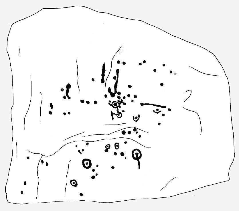
First mentioned in literary terms (surprisingly) by M.J. Walker (1956), in a short write-up following one of the Bradford Archaeology Group’s moorland walks up here. Nearly six-feet along its longest axis, there are more than 30 cup-marks on this stone, at least three with rings; plus a variety of lines linking some cups to others. At its northern tip is the lovely little ‘rosette’ design, as archaeologists have called it. Others have seen this part of the design as a solar image; a flower; the Pleiades; a ring — take your pick! It is a lovely carving though (if you’re a sad person like me, who’s into these sorta things!). What relevance – if any – it may have had to the ‘enclosure’ within whose edges it sits, is anyone’s guess!
Excavations done close by (focusing mainly on the prehistoric ‘enclosure’ within whose domain this and other carvings occur) uncovered remains of old grooved ware pottery and the remains of flints. (Edwards & Bradley 1999)
The one thing we realise from looking at this design is the difference seen between the ‘accurate’ illustration drawn by archaeologists, and the flesh and blood of the stone itself, in situ. The living rock has much greater form and expression than anything which our desire for accuracy possesses. This aint knocking any attempt to portray the cups, rings and lines on paper correctly to show what the design originally looked like; merely that there’s a world of difference between the experiential vision of the carving and that done with graphic accuracy. But we all know that anyway – so please forgive my little sojourn into speaking the bleedin’ obvious!
References:
Boughey, Keith & Vickerman, E.A., Prehistoric Rock Art of the West Riding, WYAS 2003.
Edwards, Gavin & Bradley, Richard, ‘Rock Carvings and Neolithic Artefacts on Ilkley Moor, West Yorkshire,’ in Grooved Ware in Britain and Ireland (edited by Cleal, R. & MacSween, A.), Oxbow: Oxford 1999.
Hedges, John (ed.), The Carved Rocks on Rombald’s Moor, WYMCC: Wakefield 1986.
Walker, M.J., ‘Ilkley Boulders Tour,’ in Bradford’s Cartwright Hall Archaeology Group Bulletin, 2, 1956.
Pretty easy to find. Follow directions to reach the great cup-and-ring marked Haystack Rock, then follow the footpath west and drop down the slope, crossing the stream of the Backstone Beck below you, the up the steepish slope and turn sharp left when you hit the footpath before the top of this slope. Walk onto the moor! You’ll walk right past the cup-and-ring marked ‘carving 283’ on this path, then the ruinous Backstone Circle a bit further along (50 yds to your right), but keep walking for another 100 yards until you see a large boulder a few yeards to the left of the footpath. That’s it!
Archaeology & History
I first came across this as a kid, sometime in my early to mid-teens, pottering about, looking at any old rock that caught my eye. And this one isn’t hard to miss really. One of the best memories I’ve got of this stone was when a bunch of us came walkabout up here, sometime in the autumn, when the heavens poured all day long to saturation-point — even for those in all their protective gear, such good as it was in the late ’80s to early ’90s. There started out a fair bunch of us—between 20-30 folk—with numbers dwindling sharply when we reached the Apostles. But this stone was visited way before that! Along with Bob Trubshaw, Graeme Chappell, Kaledon Naddair, Edna Whelan and a troop of other mad-folk, we stopped for a while to consider this old rock, with only three cups really visible that day. The others (those cited by the archaeo’s) weren’t picked out, as I remember. But She was pissing-it-down and the wind was really giving-it-some, so we didn’t stop here for long! We all agreed though: it was a nice, worn cup-marked stone.
Gill Head rock carvingGill Head carving (after Hedges 1986)
John Hedges and the Ilkley Archaeology bunch had cited it as ‘cup-and-ring’ in their fine work — the first time this old carving had been in print since it was first etched! A few years later when Messrs Boughey & Vickerman (2003) checked it for their survey, no new features had been noted and they just copied Hedge’s earlier notes. Indeed, it’s just a large boulder with a few archetypal cupmarks on it when it first greets the eyes. Nowt special—and with no companions either.
This is another one mainly for the mad-folk and purists amongst us.
References:
Boughey, Keith & Vickerman, E.A., Prehistoric Rock Art of the West Riding, WYAS 2003.
Hedges, John (ed.), The Carved Rocks on Rombald’s Moor, WYMCC: Wakefield 1986.
Nice n’ easy. Get to the Haystack Rock and walk on the path west (past the Three Cups Stone) and where the path swings round following the edge of the small Backstone valley, keep going for 150 yards or so. Keep your eyes out for the remains of walling in the Green Crag Settlement on your left. This flat stone is amidst the heather in and amongst the enclosure (hence the name). If you walk back and forth hereabouts for a short period, checking for flat stones amidst the heather about 20 yards off the path, you’ll find it!
Archaeology & History
Top-left section of CR-288
This is another one of those carvings which had been seen by a number of people, bimbling about across this part of the moor, before it saw the literary light of day in Hedges Carved Rocks book (1986). It’s a nicely-preserved design, usually covered over by much heather growth, but is worth the exploration if you like your cup&rings. The drawing of this stone however (in both Hedges and Boughey & Vickerman) does not convey the actuality of the carving, as we can see here. But that’s the case with many cup-and-rings: linear precision and the artisty of the carving are two very different things. As we can see here, one section of the stone has a defined ‘enclosure’ of cups etched upon the rock surface: something that is clearly missed in the archaeologist’s drawing. Check it out y’self and see what you think!
References:
Boughey, Keith & Vickerman, E.A., Prehistoric Rock Art of the West Riding, WYAS 2003.
Hedges, John (ed.), The Carved Rocks on Rombalds Moor, WYMCC: Wakefield 1986.
From Durness take the road east for a couple of miles till you see the signpost which takes you on the left-hand side of the road, down to the coast. You can’t miss it!
Archaeology & History
Findings here allege to take the history of the place into the mesolithic period, but we don’t know this for sure. An excavation here by a Mr Donald Macdonald of Sangobeg in 1904 uncovered the presence of several small bone pins, which seem consistent with Mesolithic finds elsewhere. When archaeo-excavations were done here in 1982, human remains going back to at least Iron Age were found in the simple deposit of many shells. A further analysis by the Glasgow Archaeology Unit in 1996 was prevented of some excavation by (get this!) those screwy Health & Safety regulations. Here’s a definite case for an independent group to undertake work here, as we could ignore such preventative measures (and if we drown it’s our fault!). Smoo Cave’s primary function is pretty obvious: it would have been used for both shelter and ritual.
Folklore
The folklore here tells of magick and occultism and possible remnants of rites of passage lore. For herein, many centuries ago, a powerful land-owner called Lord Reay — reputed as a master in the black arts — battled with the devil in the Smoo Cave.
The devil was keeping watch on Lord Reay following a previous dispute between the two of them, and espied him as he entered the cave. As Alexander Polson told it, the cave
“consists of three caverns, one within the other. Lord Reay had got as far as the second, and his dog, which had gone on in advance, returned howling and hairless. By this, Lord Reay knew that Satan was there before him, and bravely waited the attack, which was soon made, and his lordship fought lustily. Happily at the opportune moment a cock crew. This frightened the devil and his attendant witches, but Lord Reay stood between them and the exit. In their fright they blew holes through the roof of the cave, and this is the origin of the two openings through which the Smoo burns fall.”
Pitch black cave; protective spirit animal; encountering one’s psychological nemesis; unconscious battles with Underworld forces; rebirth of the sun at cock-crowing time; the conquering of the dark forces and renewal of Lord Reay. These are typical hallmarks probably signifying folk-remnants of shamanism and rites of passage, for which this cave may once have been used.
References:
Polson, Alexander, Scottish Witchcraft Lore, W. Alexander: Inverness 1932.
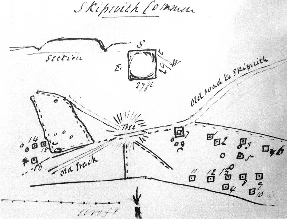
Travelling up (north) the A19, just as you get to Riccal village, there’s a small road to your right: take this! A mile along there’s a parking place just where the track veers into the woods. That’s where you’re heading. The remains of the tombs hereabouts can be hard to discern – but if your lucky you’ll either meet a local, or the virtue of patience will bring these overgrown tombs into focus! There are other tumuli a few hundred yards east and north of here aswell. If you wanna get a clear picture of them all, a full day would be a good bet!
Archaeology & History
Not to be confused with the other Danes Hills tombs a couple of miles northeast of here (as done on some other sites), the early Victorian geologist and explorer John Phillips (1853) was one of several early writers who described what, today, are known to be Iron Age tombs, scattered about a short distance east of Riccall village, saying:
“On Skipwith Common are many tumuli, old banks, and the slightly-marked foundations of ancient (turf or log?) houses or wigwams. These, by some error of tradition, are called ‘Danes’ Hills/ but, on opening the tumuli, no confirmation of so modern a date appeared. The tumuli are set in square fosses; the sides of the fossae range north and south and east and west (true). Similar facts appear in connexion with the tumuli on Thorganby Common adjacent. Burnt ashes and bones occur in the mounds; facts which suffice to overthrow the supposition of these hills being funeral heaps of the Danes of the llth century, for they then buried their dead. No instruments of metal, bone, or stone, or pottery were found.”
There were dozens of tombs that could be seen here in the past, but today many have been destroyed or are hidden by the cover of trees. A sketch-map (above) showing the rough location of many of the graves was made by the Yorkshire Antiquarian Club after a visit here in 1849 (Proctor 1855), who opened several of the barrows. Archaeologist Ian Stead (1961; 1979) defined these remains as being of the famous La Tene burials — though I’m unsure as to whether any of the tombs here had the great horse-chariots found in them, as found in the more famous Danes Graves tombs close to Driffield.
Folklore
The name of these small hills acquired their Danish title via a mix of real history and folklore. History tells of the old Danish King Harald Hardrada, who moored his fleet of ships a few miles away from here before going into battle against the armies of Northumbria and Mercia. “Dane’s Hill,” said Bogg (c.1895), “still marks the spot where the fight took place.” As John Burton (1758) told us:
“Ever since the aforesaid battle, it is by tradition to this day said, that the Danes were permitted to encamp here till they had buried their dead, and their ships at Riccal should be ready for their re-embarking for Norway.”
Local folk used to tell of the tradition of the local swamp — called Riccal Towdyke — being choked with the bodies of many slain in the battle hereabouts. Many pieces of red cloth were found all around in the neighbourhood of these tombs. However, despite this mix of fact and folklore, the tumuli were see marked on the modern OS-maps have been found to be Iron Age in origin.
…to be continued…
References:
Bogg, Edmund, From Eden Vale to the Plains of York, James Miles: Leeds n.d.
Burton, John, Monasticon Eboracense, N. Nickson: York 1758.
Elgee, F. & H.W., The Archaeology of Yorkshire, Methuen: London 1933.
Morrell, W. Wilberforce, The History and Antiquities of Selby, W.B. Bellerby: Selby 1867.
Phillips, John, The Rivers, Mountains and Sea-Coast of Yorkshire, John Murray: London 1853.
Proctor, W., ‘Report of the Proceedings of the Yorkshire Antiquarian Club, in the Excavation of Barrows from the Year 1849,’ in Proceedings of the Yorkshire Philosophical Society, 1855.
Stead, I.M., ‘A Distinctive Form of La Tene Barrow in Eastern Yorkshire,’ in Antiquaries Journal, volume 41, 1961.
Stead, I.M., The Arras Culture, Yorkshire Philosophical Society: York 1979.
Taking the A629 road between Shepley and Ingbirchworth, as you hit the staggered crossroads at High Flatts, take the west turn up the slightly sloping straight road of Windmill Lane. Just where the road ‘kinks’ at a small bend, stop and look into the field on your left.
Archaeology & History
Deemed by some as a hillfort, and others as settlement remains, what little are left of the remaining earthworks here were first described by local historian Henry Morehouse in 1861. Found about a mile west of Upper Denby, the site was described in the Victoria County History as being “on a commanding though not exactly a defensive situation on the slope of a hill.” This remark coming from the belief (and that’s all it is) that this was an Iron Age castle site. In 1924 James Petch said of it,
“The earthwork seems originally to have been almost square, and two sides and an angle remain. The external ditch is from ten to twelve feet broad in its present state.”
While Faull & Moorhouse (1981) tell of there being “evidence for Neolithic activity” here, modern surveyors reckon it as an old prehistoric settlement — which makes sense; though little of the site remains to be seen today.
References:
Faull, M.L. & Moorhouse, S.A., West Yorkshire: An Archaeological Survey, I, WYMCC: Wakefield 1981.
Morehouse, Henry James, History and Antiquities of the Parish of Kirkburton and the Graveship of Holme, Roebuck: Huddersfield 1861.
Petch, James A., Early Man in the District of Huddersfield, Huddersfield 1924.
A beautiful place found along the roadside towards Seil Island, on the B844 a few miles south of Oban. When you get near the south end of the loch right by the road, have a gander! If the waters are low you can sometimes see the ghostly island appear above the waves…
Archaeology & History
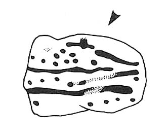
You’re lucky to see owt here – the isle has all but submerged. This old artificial island could once be clearly seen less than 400 yards south of Duachy farmhouse, near the southwestern edge of the loch. It measured roughly 10 yards by 8 yards, was built of stones, seemingly “with a boat-slip on the west side and a ‘square place’ on the east as if for a landing stage.” All trace of the causeway linking it to the shore has apparently vanished. But if you do stop here, check out the Duachy Standing Stones on the hillside behind you!
References:
Royal Commission on the Ancient & Historical Monuments of Scotland, Argyll – volume 2: Lorn, HMSO: Edinburgh 1974.#
Dead easy to find this one! Get to the Cow & Calf Hotel and walk up the slope onto the moor ahead of you. If you want a direction-pointer, head for the large, seemingly overhanging rocks which are the Pancake Stone, at the top of the ridge, but a few hundred yards to the right (west). Once you reach the level on the moor proper, you’ll see this large haystack-shaped boulder close by. That’s it!
Archaeology & History
This tends to be one of the spots I stop at when doing my tourist walks, to i) let folk get their breath back after ambling from the car park, via Hanging Stones and Map Stone; ii) to drink in the view, and, iii) to begin acquainting themselves with the landscape as it was when this stone was carved (over many decades, perhaps longer), and the animistic cosmology underlying people’s notions of their land. It can be quite an education…
Haystack Rock crushes local manFertility symbol, or Rorschach response?
The Haystack Rock was a very important boulder in the mythic landscape on this plain. It stands near the western end of the Green Crag Necropolis: a huge area of land on these moors where, quite simply, the people of these hills laid their dead. Effectively, the Haystack Rock stands on the edge of Ilkley Moor’s “Land of the Dead”.*
Highlighting this quite firmly, we find that prehistoric walling ‘separates’ this great boulder from the other part of the Plain close to its east and southern sides (walling on its western side is as yet unproven). It was a boulder that was specifically sectioned-off, away from any tombs. All along this Plain are numerous small cairns, many with rock-art nearby, and certain parts of the Plain are split into sections by ancient walling (though a precise map of the walling, tombs and rock-art on this moorland ridge has yet to be done).
J.Romilly Allen’s 1879 images
As far as the textbooks are concerned, we find the first mention of this great carved boulder came from J. Romilly Allen at the end of the 1870s. By 1900, a number of people had been here and written of its grandeur; but, as with cup-and-rings in general, its non-linear form and design elicited the usual notions of bewilderment, druids and puzzled ideas. Much like today really!
Drawing of the central design (after Hedges, 1986)
But this is a big and decent carving, with about 60 single cup-markings, 10 cup-and-rings, and various twizzly grooves and lines linking cups to others, and others going to seemingly nowhere. Some of these lines, of course, may be weathering, or weathered channels emerging from once shorter lines. We might never really know for sure what the original carving actually looked like. On the north-facing side is what looks like a decidedly human figurine etched onto this great boulder, in good old cup-and-ring style. I’ve shown this to a few hundred people and they all seem to make the same remark: it’s a woman with her legs wide open — an early form of sheela-na-gig on Ilkley Moor no less! But whether this was intentional (many folk think so), or just us seeing something we want to see (men in particular!), we might never know.
Ancient cup-marks with vandal marksMore cup-and-rings with vandal marks
The black-and-white illustration above that shows what seems to be just about all elements of the carving in considerable detail, may well be accurate, but it’s nothing compared to seeing the carving first-hand. When it comes to ancient rock-art, detailed drawings are one thing, but the real thing is altogether much much better! Check it out and see for yourself…
Folklore
I’m not too sure what credibility we should give to Nicholas Size’s (1934) extravagant claims, but this was one of the sites he alleged to have seen visions of druidic rites and ghostly figures!
References:
Allen, J. Romilly, ‘The Prehistoric Rock Sculptures of Ilkley,’ in Journal of the British Archaeological Association, 35, 1879.
Bennett, Paul, The Old Stones of Elmet, Capall Bann: Chieveley 2001.
Boughey, Keith & Vickerman, E.A., Prehistoric Rock art of the West Riding, WYAS: Wakefield 2003.
Hedges, John, The Carved Rocks on Rombalds Moor, WYMCC: Wakefield 1986.
Size, Nicholas, The Haunted Moor, William Walker: Otley 1934.
* It’s gotta be pointed out that Ilkley Moor’s ‘Land of the Dead’ extends much further than just the Green Crag. Much of the extended land above here to the south was an important area, where at some places rites of the dead were performed. The supposed ‘settlement’ nearby (as well as the lesser known one on the moor west of here, on the moor above Ilkley Crags, near Cranshaw Thorn Hill) was likely to be a place where the dead were rested for a period. But more about that in the section on the Green Crag Settlement…


")


 Allen 1879")