It seems there’s not been a lot of archaeohistory written about this ruined site — nor its companion that was once visible 50 yards to the west. In Richard Feachem’s (1977) gazetteer he described it simply as:
“a turf-covered stony mound some 10ft in height, standing in the middle of an enclosure formed by a ditch with a wall on its inner lip, which is best preserved on the west.”
Folklore
A common aspect of faerie-lore are incidences of apparent time-lapses — beloved in modern times in certain UFO encounters (Vallee 1969; Keel 1970). Such was the case here, in the story described at this ruinous old site by George Sutherland (1937). He wrote:
“Two men carrying a small keg of whiskey for the New Year festivities were passing the church of Bruan. They heard stirring bagpipe music and a few hundred yards further on they came to the Bruan Broch and found it open, and saw a number of the little folk in green dancing merrily to the music. One of the men was eager to join them in the dance and went in. The other man was more cautious and remained outside, and waited patiently until his friend would have his dance. A long weary time passed and his friend was not appearing. He went to the open door of the broch and called to his friend to come out. His friend said, “I have not got a dance yet!” After another long wait he shouldered the keg of whiskey and set out for home, never doubting but that his friend would return home before morning. Next day he called at his friend’s house to see if he had come home, and to his consternation found that he had not. Then he went to the broch in the hope of finding him there, but the broch showed no trace of a door, and no trace or soil or stones having been disturbed since the days of King Brude MacBile, and there was no appearance of man or fairy. It was an old belief that in such a case the same scene would be enacted in the same place in a year after, and accordingly on the anniversary of that day he went to the Bruan Broch. It was open, the music and dancing were going on as before, and his friend was there. He put some iron article in the door to prevent the fairies from closing it… He went to the open door and said to his friend, “Are you not coming home now?” His friend replied, “I have not got a dance yet.” He told his friend that he had been a year in the broch, and that it was surely time for him to come home now, but his friend did not believe that he was more than an hour or so there. The man then made a rush at his friend, seized him, and dragged him out by sheer force, and they set out for home together. It was difficult for him to realise that his sojourn with the fairies was such a prolonged one, but the fact that his own child did not recognise him, together with other changes that had taken place, convinced him.”
References:
Feachem, Richard, Guide to Prehistoric Scotland, Batsford: London 1977.
Keel, John A., UFOs: Operation Trojan Horse, Souvenir Press: London 1970.
Sutherland, George, Folklore Gleanings and Character Sketches from the Far North, John-o-Groats Journal: Wick 1937.
Vallee, Jacques, Passport to Magonia: From Folklore to Flying Saucers, H.Regnery: Chicago 1969.
Along the Brighouse to Mirfield A644 road, a half-mile east of M62’s junction 25 on Wakefield Road, note the woodland on your left-hand side, above the walling. Although on allegedly private land, you can approach by hopping over the wall by the main road into the woods. Wander up the slope until it levels out and, just at the edge of the tree-line, past the brilliant overgrown folly amidst a mass of rhododendrons, you’ll see the denuded edges of this earthwork. Though you might need a bitta patience seeking it out…
Archaeology & History
Very first sketch of this site (John Watson, 1775)
The remains of this low earthwork is found on the private land of Kirklees Hall and appointment is supposed to be made to explore, both this and the more famous Robin Hood’s Grave, a few hundred yards away. But if you can’t be bothered with that and find this little-known earthwork, you’ll see that it’s roughly squared in shape, though pretty overgrown. In Bernard Barnes’ survey (1982) he described it as a “square or five sided enclosure, 2-3 acres in size, with bank and external ditch”, wondering whether it was used to enclosure cattle and stretching its possible origin between the Iron Age to the medieval.
Although the classical Roman archaeologist Ian Richmond (1925) believed the site to be from that period, the archaeologist J.J. Keighley thought that the site was “more likely to be Iron Age than Roman.” He wrote:
“The earthwork in Kirklees Park is a square or five-sided enclosure with bank and external ditch… The site lies on Richmond’s trans-Pennine route. According to Armitage and Montgomerie, the earthwork is 0.5 hectares in area, but it is actually nearer 0.8 to 1.2 hectares. They compare its construction with the fort at Wincobank (South Yorkshire), stating that the bank on the counterscarp when excavated, revealed “a very rudely composed wall of undressed dry stone.”
Earlier local writers such as John Watson (1775) — whose early sketch of the site is reproduced above — and others also opted for the Roman date. But, unless you’re a bit of an earthwork fanatic, this site may not be too much your cuppa tea. If you are gonna check this out though, make sure you check out Robin Hood’s old tomb in the trees not far away. Very odd.
References:
Barnes, Bernard, Man and the Changing Landscape, Merseyside County Council & University of Liverpool 1982.
Keighley, J.J., “The Prehistoric Period,” in West Yorkshire: An Archaeological Survey to AD 1500 (WYMCC: Wakefield 1981).
Richmond, I.A., Huddersfield in Roman Times, Tolson Memorial Museum: Huddersfield 1925.
Watson, John, The History and Antiquities of Halifax, J. Lowndes: London 1775.
From the South Kirkby library, go west along Hague Lane and take the left turn up Homsley Lane on your left after a few hundred yards (keep your eyes peeled!). Go up here, past the housing estate, and where the trees begin on your left at the top of the Hilltop Estate, go thru them and as you emerge out the other side, the earthworks are all around you. In fact you’re just about in the middle of this hillfort-cum-settlement!
Archaeology & History
W.S. Banks (1871) gives an early description of this site, although he thought it to be Saxon in nature. He told that,
“About half-a-mile east of Ringston Hill, in a field between Quarry-road and Hornsley-road, is the site of a supposed Saxon camp, as it is called on the ordnance map — a large enclosure containing above three acres of land. It slopes to the north, and is now rough and uneven, and has been cast into ‘lands.’ The mound on the east, west and south is still very distinct. The northern side is much lower than the other and a ditch is cut across at that part…”
And in Banks’ day, as he told, “the history of it is not known.” But this site was later declared as a hillfort – a Brigantian one at that – for the first time by the director of Wakefield Museum, Mr F. Atkinson, following some excavation work here in 1949. Nothing much was found apart from,
“pieces of decayed and burnt sandstone and medieval pottery sherds,” though he still concluded the site to be Iron Age. Although little of its original form can now be seen due to extensive damage, infra-red aerial photography showed “traces of a five-sided annexe to the northwest, the line of the ploughed-out rampart to the south-southwest, and a possible defended entrance to the south.”
The same aerial survey also found another enclosure to the east of the hillfort.
…to be continued…
References:
Banks, W.S., Walks in Yorkshire: Wakefield and its Neighbourhood, Longmans Green & Co.: London 1871.
Keighley, J.J., ‘The Prehistoric Period,’ in Faull & Moorhouse’s, West Yorkshire: An Archaeological Survey, I, WYMCC: 1981.
From the Askwith Moor Road parking spot, walk up the road for about 500 yards and head to your right (east) onto the moor. Walk past the upper side of the disused quarry and through the heather for about 200 yards until the moorland slopes down and you’re on another flat moorland ridge. You should now be stood on the edge of the Snowden Crags Necropolis or cairnfield. There’s a large patch of bracken near the top of Snowden Crags in the middle of the prehistoric cemetery. That’s the spot!
Archaeology & History
Very little has been written of this site and for years several of us have wondered whether or not a stone circle was the antiquity that was being described in the only singular reference of the place, mentioned almost in passing in Mr Cowling’s (1946) fine survey of this area more than fifty years back, where he reported:
“A large circle of heavy material, some thirty feet in diameter, is isolated on the shelf above Snowden Crags to the west.”
But despite the various explorations of me and a number of other students on these moors over the last 20-30 years, Cowling’s curious singular reference (which some have taken as an error of judgement on his behalf) has remained a mystery. Until now!
South & west portion of the ring (photo credit: Geoff Watson)The complete circle, looking NW (photo credit: Geoff Watson)
Thankfully, with the help and attention of the hardworking Keighley volunteer Michala Potts on Thursday, 20 May, 2010, this large and very well-defined antiquity has been relocated — and a damn fine find it is indeed! It would appear (unless someone has notes to the contrary) that when Cowling did his extensive walkabouts on these and adjacent moors, this Snowden Crags Circle was much overgrown in heather and bracken; and I think we can safely assume this due to him making no further remarks regarding the site. Indeed, it would seem that Cowling’s consequent silence on the matter would lend us to think he never caught good sight of this “large circle” ever again. And upon these moors, that’s easily done when the heather gets deep up here! (numerous cup-and-ring stones on these and other northern moors still lay hidden amidst moorland undergrowth, awaiting rediscovery as a consequence of the deep vegetation) But thankfully now we have a good view of the place.
Wrongly ascribed by Neil Redfern of English Heritage to be a part of Scheduled Monument Record number 28065: Cairnfield, Enclosures, Boulder Walling, Hollow Way and Carved Rocks (it’s actually a short distance north of SMR 28065), the site here was relocated during one of The Northern Antiquarian exploratory walks, assessing the extensive walling, settlement pattern and prehistoric graveyard that scatters the central and northwestern section of the moors here. Michala Potts stopped and shouted for Dave Hazell and I to come and have a look at something she’d found whilst we were carefully peeling turf back from a previously unrecorded site about 100 yards away.
“What is it?” I asked; expecting just another small tomb or new cup-and-ring stone. But her tone of voice was different this time.
“I think you’d better take a look at this,” she emphasized.
As we walked through the shallow heather towards her, it became obvious she was standing in a rough circle of dead bracken, unbroken by the lack of rain over the previous months. We’d actually walked past it a couple of times the previous week and gave it no attention due to the depth of the dead vegetation covering the area. But this time it was different. I got within 50 yards of where Mikki was stood and my footsteps slowed; a couple more steps perhaps; then I stopped dead in my track. My arms lifted up and I held my head gazing at what she appeared to be stood in.
“Aww my god….” I said — transfixed at what was in front of me (I’m easily pleased aswell!).
Snowden Crags circle, looking west (photo credit: Geoff Watson)
I’m not quite sure how long I stood there with my head in my hands. Ten seconds or so. I couldn’t really say. I think it was when Dave caught up to where I stood, rooted, and appeared at my side. We walked a bit closer to make sure that what we could see wasn’t just another one of those curious shapes in the landscape that you find when seeking out prehistoric sites and turn out to be bugger all — but it wasn’t. Instead, Mikki Potts had stumbled upon an average-sized ring of stones, between 1-3 feet tall, and about 13 yards across, with what seemed like an entrance on its southern side, seemingly untouched in the middle of the mass of decaying bracken! It was an exciting find — as it’s not everyday that you come across a previously unrecorded stone circle. But, once we’d calmed down and walked round and round the site to make sure that something man-made was under our feet, we decided to make our way home (we’d been on the moors all day) and get back up to have a more detailed look at the place in a few days time. On Tuesday, May 25, we went back up for a second time and had a better look at the place…
It was another lucky day. For before we even reached Askwith Moor, Mikki pointed out what looked like a small cup-marking on a stone yards from the edge of the River Wharfe. We brushed off a bit of the dusty earth and were greeted the single cup-marked stone we’ve named the Riverbank Stone. It sat there all alone and dusty and we were very tempted to look for more potential carvings along the riverbank, but the Snowden Crags site was calling for attention and so up the hill we walked.
The ring of stones was still covered in a carpet of dead bracken and also had the new shoots of Spring emerging from the Earth, so we spent the next few hours picking up much of the dead bracken and carrying it beyond the outskirts of the circle, hence enabling us to see with greater clarity the monument Mikki had found a few days previously. The hot sun shone down on us all day and it took longer than we expected to shift all the bracken; but eventually, once we’d done it, we were looking at a very distinct man-made circular monument, measuring 13 yards by 12 yards across and, at its highest point, not even three feet above the present ground level. But today’s ground level is certainly much higher than it was when these stones were first placed here — at least 12 inches higher.
Rubble bank, NE-SE section (photo credit: Geoff Watson)
When Mikki first clapped eyes on the place, only a few small upright stones were sticking up amidst the mass of compacted bracken, but once all this had been brushed off we could see the stony earthworks averaging 18 inches high around the edges; and in places this outer ring is nearly 6 feet across. The ring consists mainly of smaller packing stones (perhaps thousands of them) between a number of larger upright stones — a dozen of them — making up the perimeter; but much of this perimeter is still considerably overgrown in compacted vegetation that’s prevented us seeing the ring in its proper glory: what archaeologists in the past have called a rubble bank. On its southern side is what appears to be an entrance, i.e., in this part of the circle there are no larger stones at all and only a handful of small stones have been noticed; but we must take into account the fact that we’ve done no excavation work here and this “entrance” may in fact be illusory, as the centuries of compacted vegetation (in all probability at least 12 inches deep) could be overlaying an unseen portion of the ring. This “entrance” is about 2 yards across.
The circle has similarities in size and design to the better-known site of Roms Law on Ilkley Moor. The difference between the two however is Roms Law has been robbed, whilst the Snowden Crags circle hasn’t even been catalogued. Yet there is a distinct anomaly here.
As we walked through the southern “entrance” and into the circle, we noticed what seemed to be some form of internal walling running roughly north-to-south. This “walling” started about three yards between the southern “entrance” and the inside of the ring, but then it ran roughly through the centre and all the way to the northern perimeter. This was indicated by a distinct rise in the ground which, as you walked over and stomped your feet, proved to be a mass of numerous small stones seemingly a few inches under the ground, some of which were poking through the Earth’s surface. This ingredient alone made me stop and wonder about the nature of the site. Had we come across a cairn circle of some sort? Or were we in fact stood in the middle of a small walled enclosure, which itself sits in the middle of this prehistoric graveyard? Indeed, was this walled enclosure a potential living quarter: some sort of large hut circle with a wall through the centre splitting it in two? It was hard to say for sure. On another visit to this site a couple of weeks later, in the company of Geoff Watson, Paul Hornby and Dave Hazell, this potential internal walling was given a bit more scrutiny.
We were dying to get our hands and feet digging at the heart of this ring of stones but — as yet! — we’ve managed to restrain ourselves. Although carrying off the mass of dead bracken has dislodged a couple of the small fist-sized stones at the edge of the ring (we carefully placed ’em back into position; yet it was only as much as you’d unintentionally disturb if you walked over the place a few times), we needed to use a couple of small brushes to have a look at this apparent internal walling running through the middle of the ring. But after carefully brushing off the dry dead earth, we found this “walling” was nothing of the sort! Instead, it seemed, someone at some time in the past had beaten us to this place! The central walling was, in fact, where someone had dug into the central region of the circle — probably looking for treasure or other wealthy valuables — and in doing so had dislodged a great number of the small stones that were initially in the middle of the ring, and in doing so pushed them up into small piles of stones, away from their original central position, creating an obvious long line of rocks which, once covered with dead vegetation, gave the impression of it being a length of walling. We also found that the mass of rocks that were around the centre of the ring also spread outwards covering all of the ground inside the outer kerb of stones — probably thousands of them. Geoff called this trench in the middle, the Robber’s Trench!
This begged the question: who the hell had been here, dug out a trench in the middle of this cairn circle (possibly taking out whatever remains were in the middle) centuries before the site had even been catalogued? It didn’t seem like it could have been Mr Cowling, as the covering vegetation was much more than a mere 50 years of age; and Cowling would very likely have reported any finds that he might have made here. So it is a mystery that needs solving.* Again, an accurate archaeological excavation would be invaluable here — but I wouldn’t hold your breath. Archaeological officials don’t seem interested in helping here. I was informed by Neil Redfern of the archaeology department of English Heritage for North Yorkshire that they are unable to support any funding that might help towards any decent analysis of this important archaeological arena (probably spent all their cash on prawn sandwiches and tedious autocrats, as usual).
So what we have so far is this: a large flattened circle consisting of at least a dozen upright stones that define the edges. Between these uprights are hundreds, perhaps thousands of smaller stones, making a rubble bank of a near unbroken circle, apart from where there seems a small entrance on its southern side. Inside the circle is a scattered mass of many small stones, typical of cairn material, filling the entirety of the monument; but the central region has been dug into at some time in the past, by persons unknown. It sits on a flat plain of moorland amidst the Snowden Crags Necropolis with around 30 other small cairns. But this particular site is several times larger than all the others, probably indicating that whoever was buried/cremated here was of some considerable importance in the tribal group: a local king, queen, tribal elder or shaman. Whoever it was that this monument was made for, the landscape reaching northwards from here looks across to the giant morphic temples of Brimham Rocks and the heavenly landscape beyond and above them. It is very likely that the Lands of the Ancestors this way beckoned…
References:
Cowling, Eric T., Rombald’s Way: A Prehistory of mid-Wharfedale, William Walker: Otley 1946.
Huge thanks for the help, assistance and photographs of this newly discovered site — and others nearby — to Michala Potts, Dave Hazell, Paul Hornby and Geoff Watson.
* There is a legend that tells of gold and treasure found at a nearby pre-christian well, but this site is a mile to the north of here. Another nearby treasure legend is that of a chap called “Robinson”, who came upon tons of wealth from an unknown source, enabling him to build the eloquent Swinsty Hall a mile northwest of here (though such a chap didn’t actually build Swinsty!). Perhaps there’s some grain of truth somewhere down the line about someone finding some treasure hereby…perhaps here…perhaps not!
AN APPEAL TO SOME DECENT RICH CHAP FOR SOME MONEY TO ENABLE EXCAVATION HERE!
This site and the surrounding monuments have received no archaeological attention of any worth. If it wasn’t for the fact that us amateurs had explored these (and adjacent) moors, this cairn circle would remain unknown, many of the cup-and-rings upon these moors would remain unknown, the extensive enclosures and walling (of indeterminate age and function) would remain unknown, many prehistoric tombs would remain unknown, etc. It is clearly evident that we have quite extensive domestic and ritual remains covering this small moorland region, from the neolithic period onwards. In the event that anyone reading this with a healthy financial backing behind them could work out a financial strategy enabling us to accurately excavate this and the adjacent monuments, please get in touch. We need an archaeologist to be paid for in order that we can do the duties correctly, but there is a group of a dozen volunteers willing to put a lotta work in to do the right job in this and the surrounding sites. Is there anyone out there who has the finance to enable this? I’m serious! Or are these important sites merely going to be left alone for the elements to consume and disappear over time? Surely there are one or two rich antiquarians left in this country who, as in times of old, are willing to help in the investigation of our country’s ancient monuments? Does anyone out there know how we can get the ball rolling?
Although this great and legendary cathedral is today a christian centre, it seems that the site had been deemed as sacred by a much earlier, indigenous culture — though on a scale much more humbling than the grand edifice we see standing here today! For in the northwest corner of the church grounds in 1928, a small burial cist was located. Years later, on October 2, 1975, following work here by the North of Scotland Hydro-electric Board to uncover the main supply “in an area adjacent to the north wall of the Lady Chapel,” they found a slab of stone which, when they lifted it up, covered what appeared to be a burial cist. Messrs Gordon & Gourlay (1976) narrated:
“The stone slab which the workmen had removed proved to be the western section of a larger slab which at some period had been fractured and the eastern section lost. As the interior of the cist was filled with soil similar to that surrounding it and containing a considerable quantity of dispersed human bone fragments, it was suggested that the eastern section of the covering slab had been lost when the drainage and/or electricity services were being installed. The upper surface of the slabs western section was c.35cms below ground surface. The dispersed bones in the cist were at first considered intrusive — possibly from old burials when the public services were installed — and an undisturbed deposition of bones at the base of the cist seemed to confirm this. However, an examination of the bones by Dr A. Young…and Dr D. Lunt…showed that the deposit contained remains of two adults and one child and that many of the dispersed bones could be matched with those in the undisturbed group. In fact, the deposition suggested a re-use of the cist.
“The cist measured internally 1.20m by 0.44m by 0.28m. It lay 8.4m east of the door of the Lady Chapel and 1.44m from the wall of the same. The cist was constructed from ten irregularly-shaped sandstone slabs, with one fractured slab forming the floor. On the south side, two smaller slabs had been placed on the inside of the wall to support the covering slab which only just fitted the cist, and to give extra strength to the wall since they overlapped the vertical joins of the three slabs of the south wall. The north wall slanted to meet the west-end slab 12cm from its edge, giving the cist a coffin-like appearance. The north wall was still vertical; the narrowing was probably intentional as the covering slab was only 33cm wide at that point and the bones lay apparently undisturbed, parallel to the north and south walls. It proved impossible to examine the old ground surface because of the public installations, but it did appear that the ground sloped to the west as the cist certainly did.”
Although the remains found here were not dated, it was initially thought that the cist may have been made around the period when the Lady Chapel was erected around 1250 AD.
“However, Mr J. Stevenson of the Royal Commission for Ancient and Historical Monuments pointed out that the dimensions and construction of the cist accord well with cists of known prehistoric dates in the area; the cist (therefore) would seem to be placed early in the sequences of cist development, assuming it to be prehistoric.”
References:
Cockburn, James H., The Celtic Church in Dunblane, Society of Friends of Dunblane Cathedral: Dunblane 1954.
Gordon, Alistair R. & Gourlay, Robert B., “A Cist Burial, Dunblane Cathedral, Perthshire,” in Glasgow Archaeological Society Bulletin, No.2, 1976.
The remains of this old tomb were first noted by Mr Alexander Gibson, whose photograph of the site is here reproduced. Thought by Paul Ashbee (1974) to date from between the Iron Age and Romano-British period, the site was first described in O.G.S. Crawford’s (1928) essay in Antiquity journal. It was just one of several such sites in relative proximity to each other and which, due to them being so close to the sea, have been all-but washed over by Nature’s advance. Mr Crawford told that this,
“cist on the shore…is on St. Martin’s, between Crethus Hill and English Island Point, about 20 yards from the edge of the rushy bank, and at approximately high water-mark. It is oriented north and south and is 3 feet long by 2 (feet) wide. It has now no capstone. The cist when found was full of coarse, gravelly sand and stones, which were cleared out; amongst this were parts of leg bones (the joint-ends missing) and smaller fragments; then a piece of a human jaw, without teeth, and finally the skull. The facial portion was missing. The skull fell to pieces on removal but it and all the other pieces were preserved and the cist filled in again.”
In the same article, Crawford notes that,
“nearby, to the west, were two or three other cists of the same type, and many years ago yet others were observed, both round this bay and at Lawrence’s, to the west of Crethus Hill.”
References:
Ashbee, Paul, Ancient Scilly, David & Charles: Newton Abbot 1974.
Crawford, O.G.S., “Stone Cists,” in Antiquity Journal, volume 2, no.8, December 1928.
Cairnfield (destroyed): OS Grid Reference – TQ 702 590
Archaeology & History
Ground-plan
In recent years it seems that very little has been written about this seemingly lost site, long since destroyed by the self-righteous advance of the Industrialists. It seems to have been an important place, as there were many cremated remains here in more than a dozen individual burial urns, some with flints deposited in them. The site was first described in a meeting of members of the Society of Antiquaries in 1898 by a Mr Frederick James. He talked about the site and some brief digging work around the area, thus:
“The site of the urnfield is on land belonging to Mr William Wigan, of Clare House, East Malling, and it was owing to his kind permission and active cooperation that I was enabled to visit the spot, which is on a small plateau above the River Medway, 350 yards to the southwest of New Hythe church, and between the river and the road leading from Rochester to Town Malling…
“The immediate neighbourhood…has been from time to time highly productive of archaeological remains dating from the Palaeolithic times and extended down to the Roman occupation… (But at) the Larkfield urnfield, the first indication that was afforded of the uses to which the area had been put in Romano-British times was the accidental discovery, whilst planting fruit trees, of some fragments of pottery (including portion of a Samian patera) found at the point marked A on the plan. A flat tile was found covering the fragments.”
Much more was found hereby, with the majority of the finds being “a group of urns containing cremated interments found in the urn-pits.” Although James (1898) described them as dating from the Romano-British period, from his description and illustrations it would seem that the remains here were probably of an earlier date, perhaps Iron- or even Bronze Age. But we may never know for sure.
Reference:
James, Frederick, “Discovery of a Romano-British Urnfield at Larkfield, near Maidstone,” in Proceedings of the Society of Antiquaries, 17:1, 1898.
Get to the Fence Stone carving and walk up to the top of the hill about 50-60 yards away. Once on the long flat rock, walk less than 20 yards WNW until you see the stone in the picture.
Archaeology & History
So named due to it being shaped like a little singular step on a stone, this cup-marked carving was first found in the middle of May, 2010, around the same time Michala Potts located the Snowden Crags cairn circle.
Step Stone, Snowden CragsClose-up of the cups
First described and illustrated on the Avebury Forum on June 3, 2010, this cup-marked rock is found in association with a number of (as yet) unexcavated prehistoric remains, close to some Iron- or Bronze Age walling and a distinct hut circle, close to one of the D-shaped enclosures 20 yards away.* When I first found it there seemed to be just two simple cups on it, but upon viewing it several times over the last few weeks in differing lighting conditions, it seems there may be as many as 4 cups on the southwestern face of the rock. In one of the images here, you get the impression that there could actually be five cups — but I’m gonna play safe and just say there are three such cups here.
* At least 3 large, prehistoric, D-shaped enclosures have been isolated on these moorlands, with diameters ranging between 15 and 80 yards. None of these have yet to receive serious archaeological attention!
From the Askwith Moor Road parking spot and walk up the road for about 500 yards an head to your right (east) onto he moor, above the rocky ridge known as Snowden Crags. After 100 yards or so of walking through the heather, the entire cairnfield is under your very feet! If the heather’s grown, you probably won’t see a thing.
Archaeology & History
First described in Eric Cowling Rombald’s Way (1946), where he mentions around 30 cairns on the moorland plain immediately west of the Snowden Moor settlement. These were plainly visible when Richard Stroud and I visited here in 2005, thanks mainly to the fact that the heather had been burnt away. Once it’s grown back, virtually all of these tombs will be hard to find. I first had fortune to see some of these tombs on a visit here with Graeme Chappell about 15 years ago, but only a little of the cemetery was then visible. Following another visit to the site this week, a great deal more has become visible, thanks again to heather-burning on the moors.
One of around 30 cairns on the ridge…and another one!
Curiously omitted from the Nidderdale Archaeological survey report of sites in this region (anyone know why?), the cemetery itself stretches from the western edge of the Snowden Moor settlement, several hundred yards west along the flat moorland plain towards the moorland road, stopping a short distance before the line of old grouse butts. It is highly likely that some of the stones in the grouse-butts originated in some of the prehistoric cairns along the ridge. And if summat aint done about it, there’s a likelihood this could easily happen again in the near future.
…and another!
The easternmost cairn touches the very edge of the D-shaped settlement; and another of them is right next to a cup-marked stone. Whilst a number of the cairns along this ridge are much like those found on the moors above Ilkley, Bingley, Middleton, Askwith Moor, Earby, etc — averaging 2-3 yards in diameter and less than 2 feet high amidst the peat and decaying herbage — one notable feature to many of these tombs is the inclusion of a rather large, singular boulder, against which or around are propped the smaller stones, typical of cairns found elsewhere in the region. This ‘large boulder’ characteristic is not common at other tombs in the mid-Pennines, but seems specific to this graveyard. Neither do the large boulders seem set in any particularly consistent fashion. There is the possibility that they were originally above the smaller cairn of stones, but this is purely hypothetical and non-verifiable without excavations.
The important Snowden Crags cairn circle, discovered by the hardworking Keighley volunteer Michala Potts on Thursday, 20 May, 2010, can be found on the northern part of this cairnfield.
References:
Cowling, Eric T., Rombald’s Way: A Prehistory of Mid-Wharfedale, William Walker: Otley 1946.
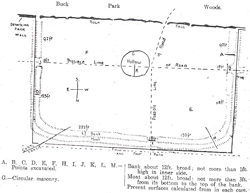
C.F. Forshaw (1908) told us that “this Castlestead…lies on the high ground between Cullingworth and Denholme, about 300 yards east of the point where te Cullingworth Road meets the Halifax-Keighley Road in Manywells Height, and over looks Buck Park Woods and the beck flowing down a deep ravine to enter the head of Hewenden Reservoir. A little to the north lies Moat Hill Farm…and the ancient burial place therewith associated.” Very little remains of the site can be seen.
Archaeology & History
C.F. Forshaw’s 1908 plan of this Castle Stead site
Just over a mile southeast of the site of (virtually) the same name — the Castlestead Ring — this here Castle Stead site had me thinking that both sites were one and the same (poor research on my behalf I’m afraid). At the moment, the archaeological period of when this site was constructed remains unknown. Thought by Forshaw (1908) to be “almost certainly a hitherto unknown Roman entrenchment,” the very slight remains left here could be Iron Age or Romano-British. In his lengthy article on the remains that could be seen here more than 100 years ago, Mr Forshaw told us:
“Several fields hereabouts bear the name Castlestead and one of these contains the entrenchment, which almost coincides within its area… The reason for the selection of this site is clear, for on no side is it commanded by higher ground: whilst one face has a natural fortification of a rock scar impassable at most points and easily accessible at none. Here very little art would make the position impregnable in primitive warfare, and it is noticeable that the most suitable part of the verge has been selected, and almost the whole of the scar has been included. It is, however, only right to state that stone has been quarried here within living memory and this may have altered the ground considerably, and may account for several features mentioned hereafter.
“The accompanying plan (above) will make the outline of the fortification clear, and from it one can readily recognise the usual Roman form. The moat and bank, the quadrangular shape with rounded corners and the entrances on three sides (and possibly on the fourth also) are characteristic. The unusual point is the selection of a natural fortification for one (the south) side.
“The question at once arises: was this a permanent stone fort? Clearly not, for the bank has been cut across at four places (A, D, H & L) and not only was no stone found — beyond such odds and ends as may be seen in any field — but the deeper, undisturbed layers of silt showed no signs of a trench in which foundations might have stood. It is noticeable that there are more stones on the crown of the bank than elsewhere. This I take to be the remains of what was thrown up in the bank. The field has been cultivated many years, so that the bank has been much reduced in height and the moat filled up.
“The original height of the bank is difficult to guess, but the moat was about three feet deeper than at present at the point H, and from the amount of soil removed we may imagine the bank about five feet higher than it is now, and solid at that; this makes a total outside slope of about 10 feet, a very formidable obstacle to surmount in the face of opposition, especially is strengthened by a stockade, such as was possibly present.The remains of the bank are capped with a layer of some six inches of bluish, silty clay. This was evidently placed there deliberately, and is in accordance with Roman work as seen elsewhere (e.g., at Castleshaw, near Oldham). There is also some slight evidence that, as at Castleshaw, the moat was once faced with irregular pieces of flat stone. The moat was some 18 feet across at the top, six feet at the bottom and five feet deep. The east and west sides were probably less strongly entrenched. Certainly the moat was much less, for rock lies only just below the sod, halfway along the western side. When the southern face is examined there are more signs of stonework, however, for where the rock is deficient the gap is filled with the remains of a dry wall which has some peculiar characteristics. In places the lower part of this wall is formed of roughly-shaped oblong blocks of large size (one has a face of 57 x 17 inches), arranged in definite tiers. This is not like an ordinary field fence, and differs even more from the ancient wall marked (probably erroneously) as Denholme Park Wall on the Ordnance map, which it continues: so it is conceivable that it may be Roman work. There is now little or no sign of a bank along the rocks bounding the southern side of the camp, but it is probable that something once existed to give cover to the defenders, and we may well imagine a low dry wall continuous with the fragments just described: and it is rather noticeable that there are more squared stones in the walls of this field than in others in the neighbourhood.
“There are no traces of buildings within the lines so far as the present investigations go, nor signs of prolonged occupation at the site. I have dug at the points indicated (on the map above) and came upon rock or disturbed silt in each case. The circular shallow hollow in the centre seems natural. It is to be remarked that the average depth of surface soil in this field is unusual, more than one foot in fact.”
Mr Forshaw then goes on to ask a series of questions, followed by his own particular answers and theory relating to the nature of these earthworks. Hopefully you won’t mind if I cite his ideas in full, despite him thinking that the remains here are of Roman origin (remains of which I don’t really wanna include on TNA). He continued:
“Was this camp on the course of a Roman road? One can only say that no definite road exists at the entrances now, but there seems some ground for thinking that a surface was prepared…at the western entrance for two reasons:
1. Just to the north the rock is covered with made soil only; but in the entrance itself irregular stones are packed in a level, solid manner, giving a strong impression of artificiality. At the southern verge of the entrance this layer ends abruptly in a line at right angles to the bank, and here it is based not on rock, but on natural silt.
2. A slight hollow runs straight westward from it for some twenty yards through the next field. This may represent a destroyed road.”
Mr Forshaw then makes a few attempts to justify this idea, including notices of footpaths and linear features near the site, aswell as citing earlier historical sources that describe Roman roads — but the ones cited are some considerable distance from this site. In summing up, he notes how no Roman finds were made here — nor indeed any finds from earlier periods — but he opted for the site being a temporary Roman outpost. The more recent opinions of this place are that it was of late Iron Age or Romano-British origin.
References:
Cudworth, William, Round about Bradford, Thomas Brear: Bradford 1876.
Forshaw, C.F., ‘Castlestead, near Cullingworth,’ in Yorkshire Notes and Queries – volume 4, H.C. Derwent: Bradford 1908.
Hindley, Reg, Oxenhope: The Making of a Pennine Community, Amadeus: Cleckheaton 2004.
James, John, The History and Topography of Bradford, Longmans: London 1876.
Keighley, J.J., ‘The Prehistoric Period,’ in Faull & Moorhouse’s, West Yorkshire: An Archaeological Survey to AD 1500 – volume 1, WYMCC: Wakefield 1981.
Varley, Raymond, “The Excavation of Castle Stead at Manywells Height, near Cullingworth, West Yorkshire,” in Transactions of the Hunter Archaeological Society, volume 19, 1997.
")


")