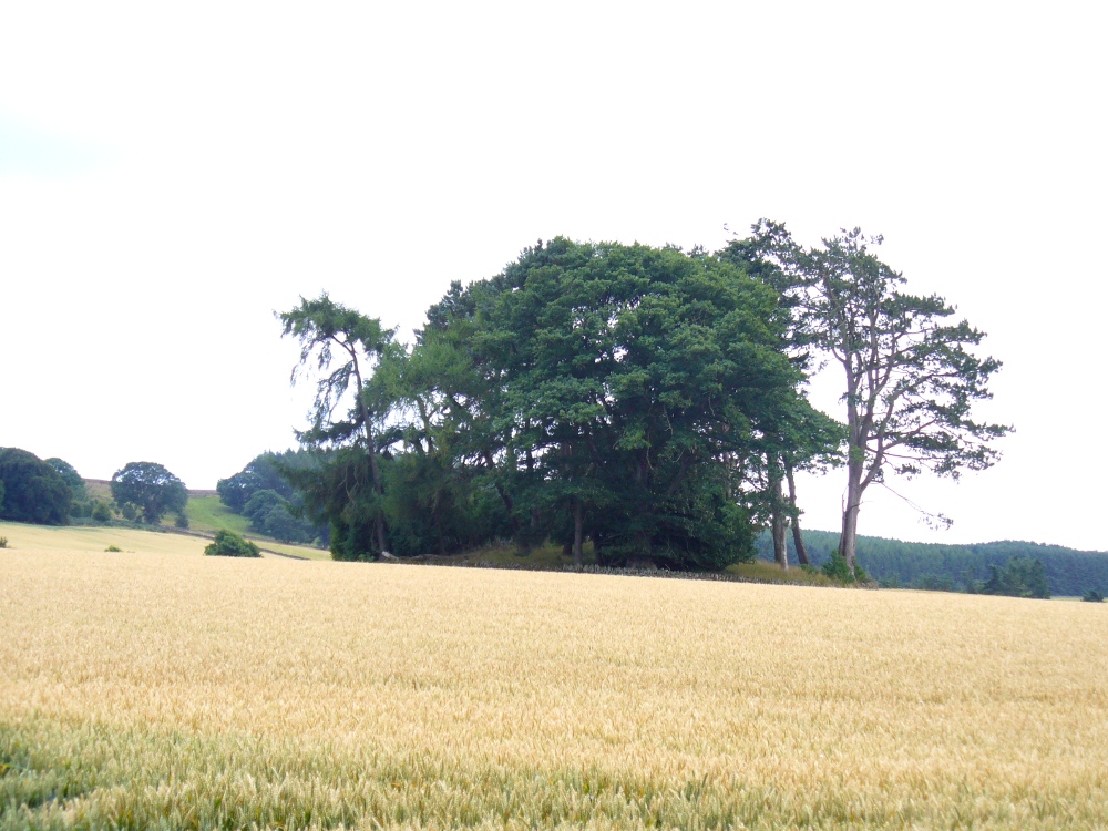
From the large village of Newtyle, take the straight road west as if heading to Kettins. About half-a-mile along, 100 yards or so past the turn-off to Kinpurnie Castle on your left – stop! In the second field after the turn-off, halfway up the slope you’ll see a large circular rise in the land with a crown of large trees sitting thereon. That’s the cairn!
Archaeology & History
Not far from the impressive Keillor standing stone is this huge prehistoric tomb. Measuring about 90 feet across and more than 7 feet high in places, the mass of rocks making up the site is now crowned by a healthy ring of trees. Near the middle of it you can see a collapsed tomb or cist, but there may be more than one inside this giant fella. Its size implies that it was a tomb or burial centre for tribal elders, leaders or shamans. When we visited the site last week, the field was still in full crop, so we couldn’t take a close look at it and must return again at a later date. Apart from a brief note of the site in the Royal Commission (1983) archaeology listing for the county, no details have been made of this huge cairn—which is incredible in itself!
References:
Royal Commission on the Ancient and Historical Monuments of Scotland, The Archaeological Sites & Monuments of Central Angus, Angus District, Tayside Region, HMSO: Edinburgh 1983.
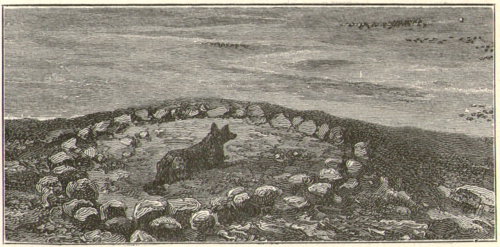
The great Yorkshire historian Harry Speight (1892) gave the directions for this place, which I’ve not located. On his walk down the southern side off Whernside, he told us to “follow the road which runs between Gunnerfleet and the white house at Winterscales, going under the long viaduct and round by Batty Wife Hole onto the main road at Ribblehead….” About 100 yards or so down the road, look over the walling into the field on the left-hand side. It’s there…..somewhere!
Archaeology & History
In an area that is pretty rich in prehistoric sites, one of our great Yorkshire antiquarians, Harry Speight (1892) seems to have described a site which our archaeologists have yet to get round to finding. He told that,
“nearer the wall there are indications of a rude, double circle, artificially formed of these dark weathered grits. The inner circle is about 20 yards in diameter and the outer one forms a narrow aisle surrounding it, with an outlet to the north; but some of the stones have been removed, probably to build and repair the adjoining fences. The situation is open and commands the country on all sides between the lofty moors and summits that hem in the dale-head. On the opposite side of the road are the remains of a couple of large cairns. They are presumably Danish. One was opened about a century ago (c.1790), and found to cover a rude stone coffin containing an entire human skeleton. The other large pile does not ever appear to have been examined. It is more than probable that many a furious battel has been waged here, as the possession of this prominent ridge, which dominates so many particular outlets, must have been of capital importance to every hostile tribe.”
Although the Victorian christian beliefs of ‘rudeness’ in everything and rampant hostile tribes, has long since subsided in the view of our ancestors. This area described by Speight does sound like an old burial ground. But from which age – and where now are the sites he described?
References:
Speight, Harry, The Craven and Northwest Yorkshire Highlands, Elliot Stock: London 1892.
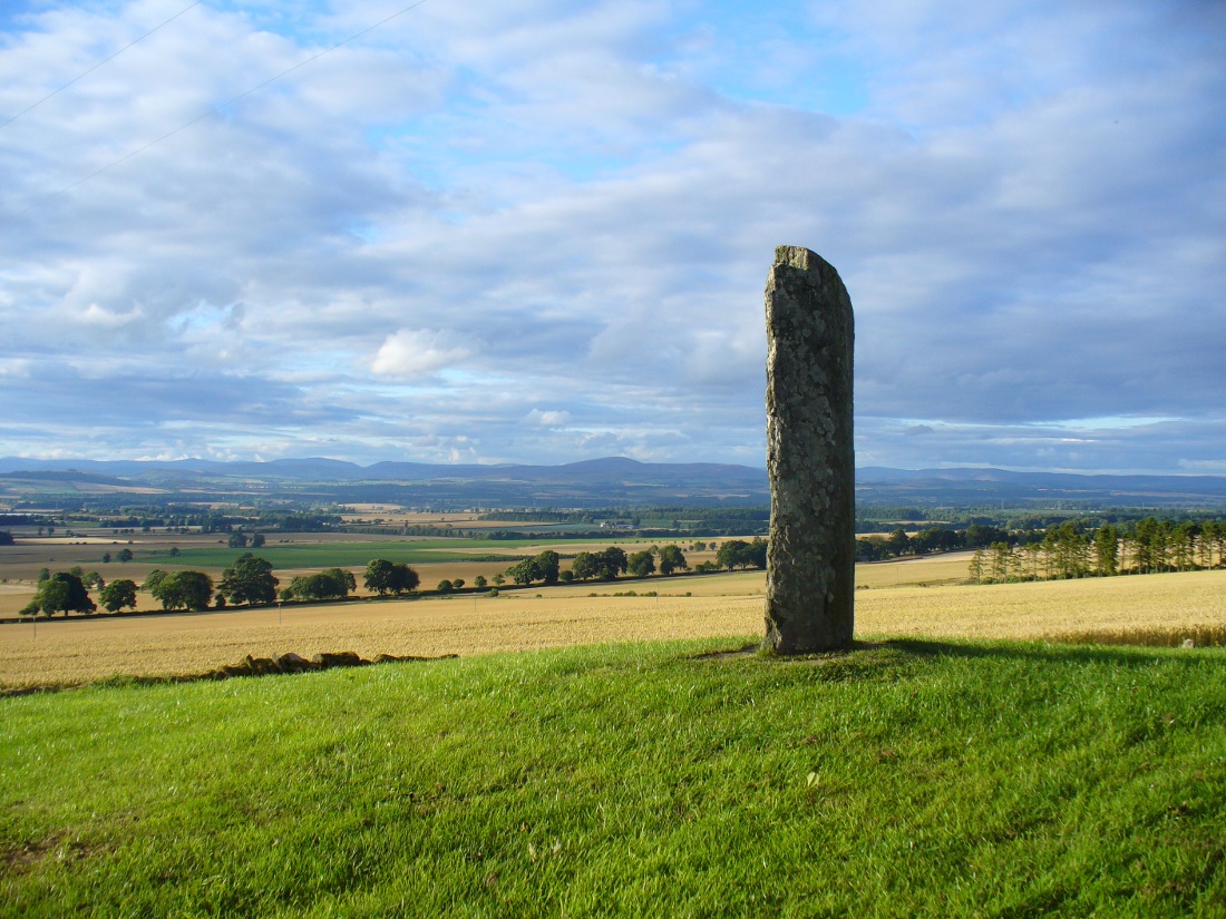
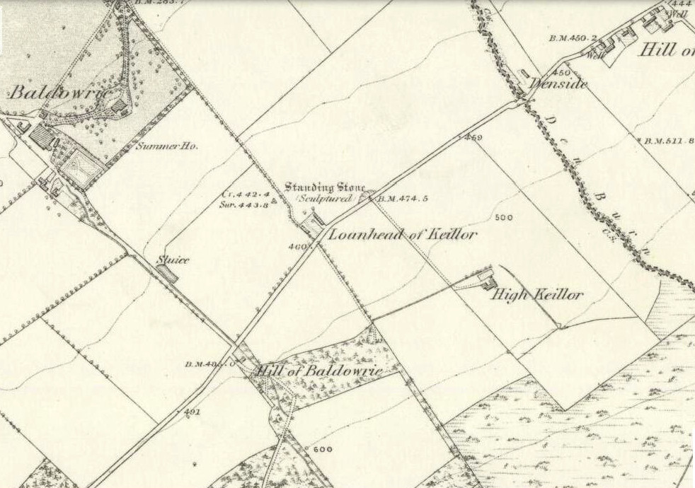
Take the minor road that runs from the small town of Newtyle (in Angus) westwards to Kettins (in Perthshire). Less than a mile on, go up the first turn-off on your left to Kinpurnie Castle and continue (past the castle) for less than a mile. Keep your eyes peeled on the right-hand side of the road, opposite the drive to High Keillor – and you can’t really miss it!
Archaeology & History
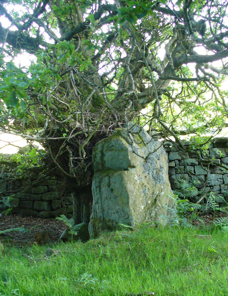
Another feel of Keillor’s Stone
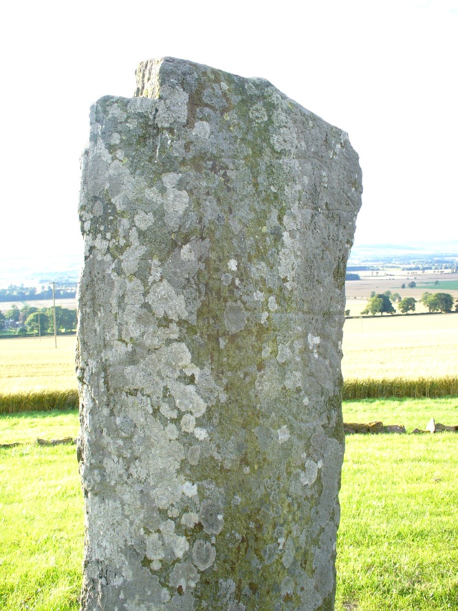
A fascinating site in an excellent setting. Here we have a 6-7 foot tall standing stone living upon a what is most probably a Bronze Age tumulus (possibly neolithic, but we aint sure), on whose south-face were carved a series of Pictish symbols many many centuries ago. In the surrounding district there is a vast wealth of similar sites (and many destroyed, like the lost Hill of Ballunie stone circle only a few hundred yards along the road), highlighting that this region was very important indeed to the prehistoric peoples of Strathmore and the Sidlaw Hills.
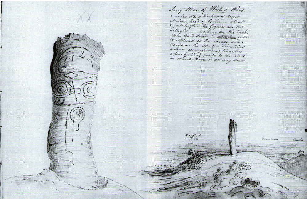
W.J. Skene’s 1832 drawing
The Keillor stone was described and illustrated by several of the giant Scottish antiquarians. When James Skene visited the site in the 1830s, the tumulus upon which the stone stands was still pretty complete, as his old drawing from 1832 clearly shows. Since then the track beside the monument has widened and the road took away half of the burial mound. But the place has lost little of its majesty.
Another 19th century historian, William Oliphant (1875), when describing the beauty and history of the Sidlaw Hills, below whose edges the old hamlet of Keillor stands, told of this,
“old and striking monument, making the spot on which it stands historical, though no syllable of the history has come down to us. It is, one writer says, “one of those remarkable sculptured monuments of the ancient inhabitants of Scotland, embellished, in this instance, with the rude outline of the boar.” Another writer says, “at Baldowrie there is an erect Danish monument six feet high. It contains some figures, but they are almost entirely defaced.”
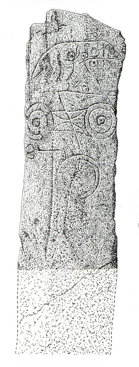
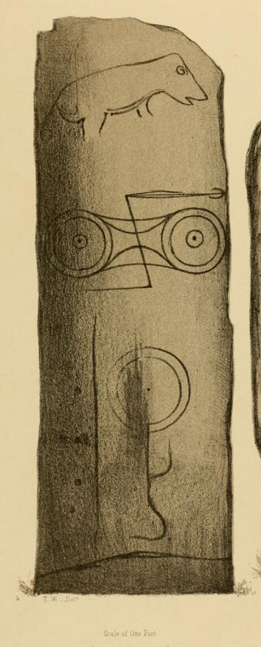
In John Stuart’s (1856) superb magnum opus he told that this carved pillar with “a boar” on it, standing on an ancient “tumulus of earth and stones” was found to have evidence of several burials inside when a dig at the site occurred which, he told, “I was present (at) in the autumn of 1854.” He described the site as follows:
Stone with carved symbols (after RCAHMS 1994)Stuart’s 1854 drawing of the carved stone
“The Stone at Keillor is placed on a tumulus on the north slope of the Hill of Keillor, in the Parish of Newtyle, and Shire of Forfar. It is a rough stone, formed of gneiss, convex in front, and rugged behind. The tumulus on which it is placed is formed of earth and stones, and several cists containing bones have been found in it. Ancient sepulchral remains have also been dug up in various parts of the adjoining field.
“The stone was broken across some years ago about a foot above the ground, but the parts have recently been clasped together, and the stone replaced in its original site by orders of Lord Wharncliffe. The present drawing was made with much care by Dr. Wise, and is more perfect than the copy in Mr. Chalmers’ volume. The surface of the stone is so rough, that it is sometimes with difficulty that the incised lines can be satisfactorily distinguished from natural fissures, but having examined the stone in a variety of lights, and compared Dr. Wise’s sketch with the original, I am inclined to think that the drawing is as satisfactory as can now be obtained. There is a rough sketch of the stone among Dr. Hibbcrt’s papers, with a supposed Gaelic inscription at the top, meaning “the burying place of the slain,” furnished to Dr. Hibbert by the late Mr. Donald Gregory. Of such inscription 1 could see no trace.”
The old stone himselfFaint carvings just visible
And as far as I am aware, this Gaelic inscription has not subsequently been recorded. But considering the position of the stone in the landscape, it’s understandable if some of the carvings have eroded away by simple weathering. Indeed, when Paul Hornby and I visited here only a couple of weeks ago, despite the weather conditions being excellent, the carvings were difficult to make out. Modern interpretations differ between the topmost animal carving being either a wolf or a boar. Below this we see the more common Pictish symbol described as a double disc and Z-rod symbol, for which academia still struggles to afford cogent explanations.
Keillor stone on 1865 map
Whilst the prehistoric age of the tumulus on which this stone stands is not in doubt, we don’t know exactly when this stone was first erected here. Whilst some of the early accounts—including the Ordnance Survey team who first visited here in 1860—describe it in an upright position, when A.J. Warden (1880) wrote about it in his massive survey of the region, he noted that wasn’t always the case:
“On the north slope of the Hill of Keillor, in the parish of Newtyle, there is a rough stone composed of gneiss, somewhat convex in front but rugged behind. It is placed on a tumulus formed of earth and stones, and several cists containing bones were found in it; while, in the adjoining field, ancient sepulchral remains have also been found. The stone was broken across about a foot from the ground, but the parts have been again united and the stone replaced on its original site. On the stone there is the figure of an animal, below which are the spectacle and other symbols, all incised.”
The stone presently stands on a modern plinth to protect it from the elements and such things. It was erroneously described in the Royal Commission’s 1999 survey of Pictish monuments as being just “1.4m in height”, whereas it is in fact some 6½ feet tall, or around 1.98m.
The Great Pyramid to the northwest
The view from here, east, north and west is superb. The high rolling hills of Angus stretch into the north and eastern skies; whilst more westerly are the grand olde mountain ridges into deepest Perthshire. And looking northwestwards from our old standing stone, one shapely mountain in particular is notable, standing out upon the ridge of distant hills: a great pyramid which I initially thought may have been Ben Vorlich. But thanks to the help of several local people, have found that it is in fact Schiehallion – the great Mountains of the Fairy Folk, about 50 miles away! Some folk think that it may have had relevance in the animistic formula with this monument—and I’ll hazard that it did too…
…to be continued…
References:
Allen, J. Romilly, Early Christian Monuments of Scotland, 1903.
Coutts, Herbert, Ancient Monuments of Tayside, Dundee Museum 1970.
Guthrie, James C., The Vale of Strathmore – Its Scenes and Legends, William Peterson: Edinburgh 1875.
Jervise, Andrew, Epitaphs and Inscriptions from Burial Grounds and Old Buildings in the North-East of Scotland – volume 1, Edmonston & Douglas: Edinburgh 1875.
Mack, Alastair L., Field guide to the Pictish symbol stones, Pinkfoot Press 1997.
MacPherson, J.G., Strathmore: Past and Present, S. Cowan: Perth 1885.
Marshall, William, Historic Scenes of Forfarshire, William Oliphant: Edinburgh 1875.
Royal Commission on the Ancient & Historical Monuments of Scotland, South-East Perth: An Archaeological Landscape, HMSO: Edinburgh 1994.
Royal Commission on the Ancient & Historical Monuments of Scotland, Pictish Symbol Stones: A Gazetteer, Edinburgh 1999.
In seeking out some of the monuments in the area north of Collace village, we enquired upon one of the landowners for anything they might know of the sites we were looking at. Whereupon (as happens occasionally), the gent concerned—a local man—after ascertaining that we weren’t from the National Trust or a similar group, informed us that many years ago he was ploughing the field over where a small subsidence had been, when his tractor fell into a large hole that appeared in the ground due to the weight of his vehicle! It was a souterrain, he told us; but once he managed to retrieve his tractor from the hole in the ground by calling upon one of his neighbours, he completely covered it and filled it in again.
Despite him telling us to keep it to ourselves, it does appear that aerial photography from the 1990s seems to have uncovered the location of the site. Indeed, by the look of things, there may be more than one!
Take the same directions as if you’re visiting the multiple-ringed Agra Woods petroglyph (West Agra 8). From just below here, keep to the woodland side, and follow the line of tall drystone walling along to the east for a hundred yards or more, keeping your eyes peeled for the stone in question, just in front of a nice oak tree. You can’t really miss it!
Archaeology & History
Not too far away from the scattered cluster of West Agra’s cup-and-ring stones, can be found this very bulky six foot tall standing stone, near the edge of the old walling on the inner-side of the Agra Woods. It was rediscovered by Paul Hornby on a Northern Antiquarian outing in May 2011, who told it to be “quite a massive thing!” (I’ve yet to visit the site so can’t give my personal impressions of the site)
Nothing seems to known of the whereabouts of an old prehistoric cairn, positioned on one of the hills in Aberdour parish. It was described in the Old Statistical Account of the region around 1791, and may have been on the place known as White Law on the northern edge of the town, now built over. The account told:
“Not far from the village of Aberdour, on a flat on the top of a hill, there is one of those cairns or tumuli so frequently met with in Scotland. The farmer on whose farm it is situated, when carrying away stones some years ago, discovered a stone coffin in which were found the skeleton of a man, the head of a spear made of copper, with the copper nails by which it had been fixed to the shaft, and a piece of clear substance, like amber, supposed to have been an amulet. The coffin, with a great part of the cairn still remain. The tumulus has been conical, the coffin being exactly in the centre of the base, from which to the circumference, it measures 20 paces. The height cannot now be ascertained. There have been found in the same cairn several earthen vessels containing human bones. The vessels were flat, narrower at the bottom than top, and without any covering. The farmer digging in the same field, in another place, found such a quantity of human bones that he was obliged to desist.”
The finding of ‘copper’ spearheads in the tomb indicates either a Bronze Age or Iron Age period. The brilliant Audrey Henshall (1965) thought the metal remains were more probably bronze. An exploration of the field-names of the area might prove useful in helping to locate the whereabouts of this cairn.
References:
Henshall, A.S. & Wallace, J.C., “A Bronze Age cist burial at Masterton, Pitreavie, Fife”, in Proceedings of the Society Antiquaries, Scotland, volume 96, 1965.
Royal Commission on the Ancient & Historical Monuments of Scotland, Inventory of Monuments and Constructions in the Counties of Fife, Kinross, and Clackmannan, HMSO: Edinburgh 1933.
Along the A823 road from the Pool of Muckhart up to Glendevon, watch out for the small left turning opposite the car-parking spot by the Castlehill Reservoir a couple of miles up the road. Walk up this small road a mile or so to the Glenquey reservoir, taking the footpath on your right and making sure you walk along the north-side of the waters. You’ll eventually reach a small set of beautiful mossy green waterfalls (with the rounded fairy hill of Maiden Castle ahead of you). This is the Garchel Burn. Take steep the path up the side until it levels out a bit, heading for the small clump of stones on the near skyline a couple of hundred yards ahead. That’s it!
Archaeology & History
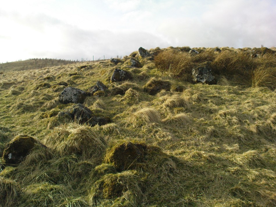
This is a curious little cluster of seemingly multi-period remains sitting on the edges above the gorgeous waters of the Garchel Burn. The Royal Commission Canmore report ascribes the scattered rocky cluster below the deer-fencing as the main hut circle – and the line of walling running slightly down the slope does have that traditional Iron Age look about it. But it’s yet to be excavated. The larger ring of stones constituting the main ‘circle’ is very much bogged-down, literally, amidst tussock and marshland, with an arc of stones running away from the circle and it’s obviously been made use of it by people in more recent times.
Small ‘hut circle’ to centre
Below the larger rock cluster is a lovely oval structure, built upon a slight rise overlooking the burn, with all the rocks in the structure overgrown with age and grasses. Tis a beautiful spot to sit and hear the silence of the waters around you. Aerial images show the outlines of other roughly circular remains in the same area, but none are yet excavated – and some are distinctly much later in period, medieval by the look of things and very probably used by farmers in more recent centuries. In all probability, there are more things to be found up here, hiding within the forests…
Follow the directions to reach the small Rivock East Carving just on the level of the small moorland. From here, walk less than 100 yards east, staying just on the edge of the moor, keeping your eyes peeled for the irregular shaped rocks running in lines roughly parallel with the footpath above the edge of the crags.
Archaeology & History
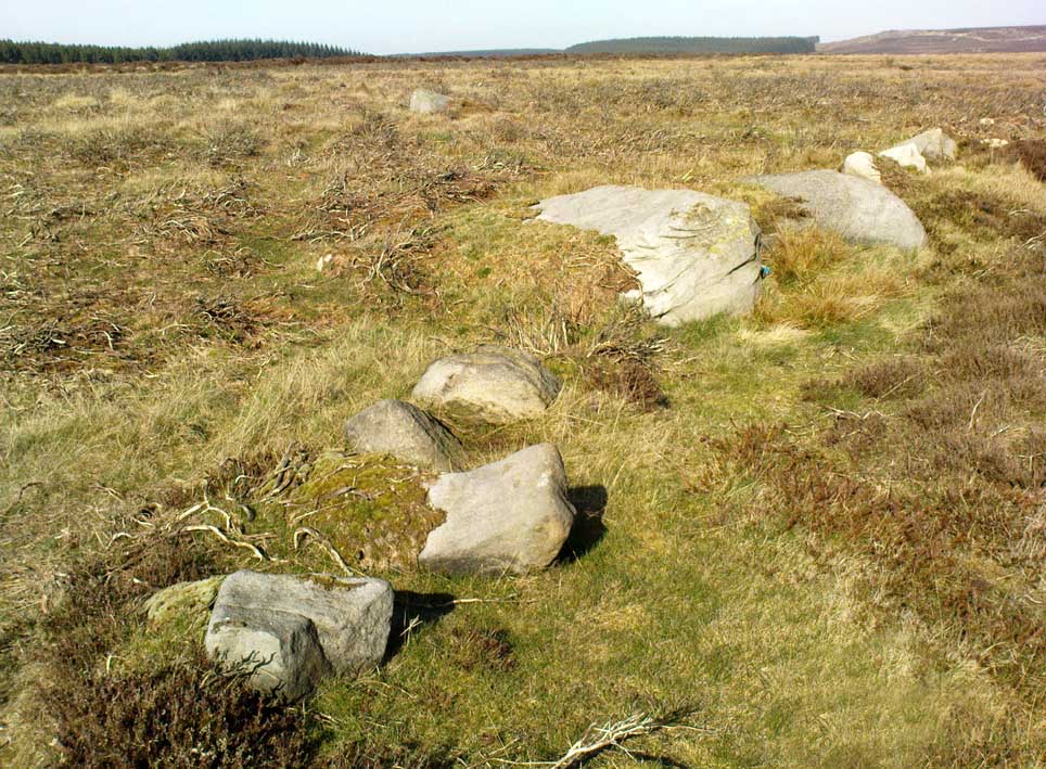
Recent explorations in and around the Rivock Edge area found, not only a number of undiscovered cup-and-ring stones, but the overgrown remains of an undoubted prehistoric enclosure on the ridge of moorland above the rock escarpment which has not previously been reported in archaeological surveys. Much of the time the area is covered in deep heather, but thanks to this small section of moor being burnt back a short while ago, the lines of walling that mark the enclosure are there for all to see. It’s obvious that some sections of the old walls have been removed in the not-too-distant past for use in more modern walling and, nearby, old quarries and farming have probably been responsible for other destructive elements.
Easternmost line of Rivock enclosure walling
This enclosure is of a rough, rounded, scalene triangular formation, with the main piece of extant walling running roughly northeast-southwest. The walling is typical of other settlements and enclosures in the region, probably Bronze Age in nature, Iron Age at the latest, with some natural earthfast boulders marking parts of the outline and many smaller pieces of rock and packing stones being added to build up the structure. The same layout is found at other nearby prehistoric enclosures at Crow Well, Dumpit Hill, Snowden Moor, Woofa Bank and many others.
Of the larger upright stones in the Rivock Enclosure, several of them stand about three feet high, with some of them having been knocked down. The longest line of walling, running roughly east-west, is less than 50 yards long; whilst the enclosure wall running roughly north-south on its eastern side is 30 yards long. Much of the walling along its northern side appears overgrown and sections of it are missing.
For a long time I puzzled as to whether there had been any settlements on this part of Rombald’s Moor, rich in cup-and-rings stones — and at last we find that there was at least one such site. Forays back and forth across the level ground all around here failed to locate any other similar enclosure remains; but it may be that some have been covered (or were destroyed) in the adjacent forestry plantation to the west. Further explorations by fellow antiquarians may prove worthwhile when the forest is cut down in the next few years.
From Ilkley, take the Cowpasture Road up past Cow & Calf rocks, the hotel and along the moorside. A few hundred yards further, just before the next farm-building on your right, walk up the Rushy Beck path to the top. Crossing the stream at the top, now walk diagonally south-ish into the heather for some 200 yards, a short distance before the hillside begins to rise up again onto the next ridge. Remains of this ‘enclosure’ is all around you!
Archaeology & History
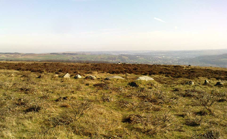
When the normal moorland vegetation covers this prehistoric site, you’d barely know there was anything here apart from various rocky rises and undulations in the ground and perhaps, if you were seeking out old stuff, what would seem to be lines of stone walls bending away onto the moor. But when the heaths have been burnt back, a whole new vista unfolds itself! You see before you a fantastic, well-preserved, unexcavated prehistoric enclosure, whose origins are probably neolithic, but whose history and use stretched through the Bronze Age and into the Iron Age—and it’s not alone! East, west and south of this particular enclosure, other prehistoric walled structures are found stretching all across the landscape hereby, structurally similar and also used over very long periods in prehistory. For antiquarians and historians alike, this is a truly impressive place indeed. In all honesty, the description I give here does not do the place justice!
Northwestern section of enclosure walling
Things like ‘settlements’ and ‘enclosures’ are traditionally relegated by purist archaeologists to be little more than domestic or utilitarian sites: places where our ancestors kept cattle; or were used for defensive purposes; or lived for long periods of the year. Of course, these simple ideas are effective and true at some places; but here at Woofa Bank—in this particular enclosure—something more than just domestic activity was enacted, and over the period of many centuries by the look of things. We surmise this by the incidence of at least fifteen cup-and-ring stones being found within the enclosure itself; and at its very centre is a small standing stone, not previously recorded, that has perhaps five petroglyphs around it. The presence of such a large cluster of cup-and-ring stones close together within the enclosure would seem to suggest ritual activity.
Carved rock & central stoneClose-up of, dancing anthropomorphic figure?
One of the carvings at the centre of the enclosure (listed in the Boughey & Vickerman survey as Carving 372) has been suggested to represent a dancing human figure (the image here shows the anthropomorphic element), which it may well be. The incidence of this central stone and its surrounding petroglyphs has important magico-religious implications, relating it as a site used for creation myth narratives and repetitions (transpersonal explorations at this site may prove worthwhile). The wider extended enclosure with more petroglyphs contained inside it, suggest that additional ritual performances were enacted here; these may have had something to do with the cluster of prehistoric tombs scattered on the moorland plain 100 yards to the west, but we might never know.
Easternmost standing stone
It seems that the walled enclosure itself was constructed around the earlier cup-and-ring stones, probably many centuries later—but we need excavations here to give us more precise details. Much of the enclosure walling itself has the hallmarks of being late Bronze Age to Iron Age, whilst we know that prehistoric rock art can date back into the neolithic period; and from this period Eric Cowling (1946) reported that, at Woofa Bank, “at the western end of the ridge,” just above this enclosure, a neolithic flint site existed.
Cowling’s 1946 plan
Cowling (1946) himself was one of very few archaeologists to even mention this impressive site, in a section exploring the “Iron Age” sites along Green Crag Slack at the eastern end of Ilkley Moor. He wrote:
“At the other end of the site under the shadow of Woofa Bank and near the source of the Rushy Beck, is another D-shaped enclosure apparently unfinished. The plan is of a circle with a flattened side and does not exceed twenty-four yards across in any direction. Here the enclosing wall shows five or six courses at the lower end side and a simple entrance to the west.”
Western entrance to enclosureStone marking eastern entrance
Though Cowling’s measurements are way out! The enclosure itself is much larger than he describes. For the most part, three-quarters of it give the impression of it being a large oval shape, but the design and outline of the walling changes on its southeastern side and kinks inward, in an arc, to eventually meet the walling in the middle eastern section. Its entire circumference measures approximately 220 yards all the way round; it is 65 yards across east-west; and about 61 yards north-south. The average height of the main walling is between 2-3 feet tall, and is made up of many large rocks, some of them positioned upright as standing stones, all packed together with earth and countless thousands of smaller stones. The walling itself is between 2-3 yards wide in many places and has two main entrances: one near the middle of the western wall and the other almost opposite to the east. The eastern entrance is marked by a standing stone between 3-4 feet tall. No gaps are visible at all on the northern curved section of the enclosure. On the overgrown southern edges, not all of the walling is visible and much of it is overgrown. On the whole it’s still very much as Cowling found it, with the arc of walling in this part of the enclosure difficult to make out clearly. There is also another line of walling that runs off to the east, beyond the main enclosure itself.
Carved rock in western wall
The clearer, more visible western line of walling, running south of the entrance on that side, has a large singular cup-and-ring stone laid right along its axis (carving 366 in the Boughey & Vickerman [2003] survey), a short distance before the walling changes direction east-west and runs along the bottom of the slope.
Folklore
Tradition tells that the tribal people from this site were involved in a battle with the Romans along this moorland plain.
…to be continued…
References:
Bennett, Paul, The Old Stones of Elmet, Capall Bann: Chieveley 2001.
Boughey, Keith & Vickerman, E.A., Prehistoric Rock Art of the West Riding, WYAS: Wakefield 2003.
Cowling, Eric T., Rombald’s Way, William Walker: Otley 1946.
Eliade, Mircea, Images and Symbols, Harvill Press: London 1961.
Hedges, John (ed.), The Carved Rocks on Rombalds Moor, WYMCC: Wakefield 1986.
Size, Nicholas, The Haunted Moor, William Walker: Otley 1934.
This once important healing stone that was moved a short distance (from grid reference SN 1775 1875 to SN 1770 1874 according to officials) to its present spot, around 1925, whilst having a long history according to the folk traditions of Carmarthenshire, was previously questioned as an authentic site by none other than Prof John Rhys (1875), following his visit to the site in the 1870s. Although Rhys seemed an isolated voice, some modern archaeologists have also questioned its veracity. It’s difficult to say precisely what the original nature of the stone may have been, but it was certainly accommodated in medieval times as a healing stone and used in conjunction with a pagan well – which was of course, accommodated by the Church. If the stone itself had a megalithic pedigree, as some have believed, we know not what it may have been…
As Janet & Colin Bord (2006) wrote, the stone “still survives, but to the casual observer it looks like any other abandoned block of stone,” sitting innocuously within the ring of trees surrounding the church. An early account of the stone was written by E.L. Barnwell (1872), who told:
“The present church of Llangan in Carmarthenshire is a wretched structure, built in 1820, and is about to be removed, as the population has long since migrated to some distance from it, and in a few years even the memory of Canna’s church having once existed here may cease. There is, however, a relic still left, which we trust will not be overlooked by the local authorities, as indeed it seems to have been hitherto ; for no notice occurs of it in the account of the parish in Lewis’s Topographical Dictionary or any other work. This relic is a rude stone, forming a kind of chair, lying in a field adjoining the churchyard, and about thirty or forty yards from it. When it was removed to its present position is unknown. There was also a well below the church called Ffynnon Canna; and there is still a small brook available, if required, for following the rules prescribed to those who wish to avail themselves of the curative powers of the saint’s chair. It appears that the principal maladies which are thus supposed to be cured are ague and intestinal complaints. The prescribed practice was as follows. The patient first threw some pins into the well, a common practice in many other parts of Wales, where wells are still thought to be invested with certain powers. Then he drank a fixed quantity of the water, and sometimes bathed in the well, for the bath was not always resorted to. The third step was to sit down in the chair for a certain length of time; and if the patient could manage to sleep under these circumstances, the curative effects of the operation were considerably increased. This process was continued for some days, even for a fortnight or longer. A man aged seventy-eight, still living near the spot, remembers the well and hundreds of pins in it, as well as patients undergoing the treatment; but, about thirty or thirty- five years ago, the tenant carried off the soil between the well and the watercourse, so as to make the spring level with the well, which soon after partly disappeared, and from that time the medical reputation of the saint and her chair has gradually faded away, and will, in the course of a generation or two, be altogether forgotten.”
Folklore
In Wirt Sykes (1880) classic text, he told us that the field where the original Canna’s Chair may have been, possessed fairy-lore that we find at other sites, usually ascribed as prehistoric. He wrote:
“In the middle of this parish there is a field called Parc y Fonwent, or the churchyard field, where, according to local tradition, the church was to have been originally built; but the stones brought to the spot during the day were at night removed by invisible hands to the site of the present church. Watchers in the dark heard the goblins engaged in this work and pronouncing in clear and correct Welsh these words, “Llangan, dyma’r fan,” which means, “Llangan, here is the spot.””
References:
Allen, J. Romilly, The Monumental History of the Early British Church, SPCK: London 1889.
Baring-Gould, S. & Fisher, John, Lives of the British Saints – volume 2, London 1907.