Weeping Stone, Fladaigh Chuain, Skye

Legendary Rock: OS Grid Reference – NG 3638 8091

Getting Here

Unless you’ve got your own boat, forget it!  This one’s miles out on the isolated uninhabited island of Fladda-chuain about 5 miles off the northwest tip from Duntulm, Trotternish.  I wouldn’t mind a coupla weeks alone on the isle though – if anyone can get me there!

Archaeology & History

The little rocky island itself was allegedly another of the many visiting places of St. Columba in his many ventures to sell his religion to the peasants and displace the druids, who were alleged to practice pre-christian rites here and deemed it as sacred.  St. Columba’s chapel on this island was built to displace the heathen traditions.

Folklore

In Otta Swire’s (1961) excellent work on the folklore and history of the Isle of Skye, she wrote:

“In Duntulm Bay lies Tulm Island and beyond it, in clear weather, Fladdachuan, Fladda of the Ocean, can be seen. In olden times this was a sacred spot, held by many to be Tir-nan-Og, the Isle of Perpetual Youth, which lay in the west; here it is always summer and the sun never sets. The puffins recognized its sacred nature and never began any venture until they had circled the island three times sunwise; this they did also on arriving in Skye and before leaving it. It was held by some to be the reason why in Skye people used to turn three times sunwise before starting a new enterprise. The Druids held it in veneration and St. Columba caused a chapel to be built there. On its altar lay a black stone which some say was the original altar stone of the Druids and which was known as the Weeping Stone because it was always wet. Until fairly recently fishermen used to land on the island and pour three handfuls of seawater on the stone to procure favourable winds or to stop bad floods. The Weeping Stone no longer exists, or at least is no longer to be found where the altar once stood.”

I can’t find anything more about this place.  Does anyone know owt more about it?

References:

  1. Swire, Otta F., Skye: The Island and its Legends, Blackie & Son: Glasgow 1961.

© Paul Bennett, The Northern Antiquarian
Achnancarranan, Islay, Argyll

Standing Stones:  OS Grid Reference – NR 3895 4606

Also Known as:

  1. Canmore ID 37581

Getting Here

From Port Ellen take the A846 road east to Laphroaig, and on the far side of the village, past the small forested part on your left, walk up the slightly sloping hill alongside the small River Kilbride.  Over a couple of walls on your way up, look up the small hill to your right (north) and you’ll see these large standing stones.

Archaeology & History

A triple-stone row no less!  Although only two of these stones are upright, a third central prostrate stone is included in archaeological surveys as an original upright.  And it seems likely. Although passed over in Alexander Thom’s astroarchaeological analyses, Clive Ruggles (1984) looked at this stone row and found the alignment here to possess no solar or lunar function.  But if it aligns north the mythic relationship obviously relates to death, as North “is the place of greatest symbolic darkness” where neither sun nor moon ever rise nor set.   There may have been an early association with Alpha Draconis, or Thuban in the constellation of the Dragon: the Pole Star in early neolithic times around which the heavens were seen to revolve by our ancestors and hold the pillar of the sky in place.  But we may never know.  Perhaps by the time these monoliths were erected, the mythos relating to A.Draconis may have faded…

The stones are found amidst a scatter of other neolithic and Bronze Age remains.  In the Royal Commission (1984) report on the stones they described the respective monoliths as follows:

“The north stone, measuring 1.28m by 0.35m at the base and 2.70m in height, rises with a gradual taper, the top curving gently to its highest point at the top of the south side.  The centre stone, now prone, has fallen onto its E face and lies embedded in the ground with its upper surface (originally the west face) flush with turf; it is 3m long and up to 0.9m broad.  The south stone measures 0.80m by 0.40m at the foot and 2.85m in height.  It leans towards the west and the top slopes down sharply from the south to a shoulder 2.1m above ground level on the north side.”

…to be continued…

References:

  1. Burl, Aubrey, From Carnac to Callanish, Yale University Press 1993.
  2. Royal Commission on the Ancient & Historical Monuments of Scotland, Argyll – volume 5: Islay, Jura, Colonsay and Oronsay, HMSO: Edinburgh 1984.
  3. Ruggles, C.L.N., Megalithic Astronomy: A New Archaeological and Statistical Study of 300 Western Scottish Sites, BAR: Oxford 1984.

© Paul Bennett, The Northern Antiquarian


Cultoon, Portnahaven, Islay, Argyll

Stone Circle:  OS Grid Reference – NR 1956 5697

Also Known as:

  1. Cultoun

Archaeology & History

Following excavation work on this denuded megalithic ring in 1974 and 1975 under the joint auspices of the Islay Historical Works Group (IHWG) and the Hunterian Museum of the University of Glasgow, under the direction of archaeologist Dr Euan MacKie (1976), with the intent of actually restoring the site to what they thought was its former glory by resurrecting the fallen monoliths in this ring of stones, some intriguing facts came to light.  Dr MacKie wrote:

“This site stands on a low, shallow knoll about a mile from the sea and with an extensive peat bog to the west.  Before excavation the stone ring consisted of a rough oval of two standing stones and ten fallen ones, the latter being partly or nearly completely buried under the turf.  The dimensions of the ring were about 45 by 40 yards.  The excavations were based on a 6m grid and the ain was to explore as much as possible the perimeter of the ring and part of the interior.  In this way it was hoped to identify the sockets from which the prone monoliths were assumed to have fallen and thus to discover the exact positions at which they were to be re-erected…

“It soon became clear that the prone monoliths had not in fact fallen out of their sockets.  All of them lay on the old ground surface under the peat which had evidently begun to grow — in the 8th century BC according to one C-14 date — after the site had reached its present condition.  Some stones had no socket next to them and a number of sockets were found without adjacent stones.  Several stones lay next to sockets in such a position as to make it clear that they had never been set up.  The site had evidently been abandoned in the middle of construction and those sockets already dug were allowed to fill slowly with rubble and silt.  One socket was discovered which had been deliberately filled up, confirming that some change of plan had occurred before the final abandonment.  Cultoon is the only stone circle apart from two phases of Stonehenge to have revealed evidence of never having been completed. (my italics, Megalithix)

“The finds were few and consisted of mesolithic flint microliths and some larger, presumably neolithic flints.  The former were all on and in the buried topsoil — the circle builders’ ground surface — while the latter were on the land surface and in the lower part of the peat; these last included scrapers and are hollow-based points of Bronze Age type.  Of particular interest was the discovery of caches of flint flakes in the peat next to the two standing stones.  They appear to be deliberate offerings and suggest that the site retained its sanctity for some centuries after its abandonment.”

…to be continued…

References:

  1. MacKie, Euan, “Cultoon, Islay,” in Glasgow Archaeological Society Bulletin, No.2, 1976.

© Paul Bennett, The Northern Antiquarian


Tobar Mor, Tarbert, Gigha, Argyll

Sacred Well:  OS Grid Reference – NR 6564 5190

Also Known as:

  1. Canmore ID 38609
  2. Great Well of the Winds
  3. St Beathag’s Well
  4. Tobar Bheathaig

Folklore

There are a number of sacred and healing wells on this small island, but this site in particular was deemed magickal by folk from far and wide.  Found on the northwest slopes of Cnoc Largie (around which are other heathen spots) this legendary site had an attendant keeper of the well:

“an aged female direach, or guardian, whose uncanny powers could be commanded by a small offering of silver.  Following this the cover of the sacred well would be removed in order that its waters might be ceremonially cleansed with a white clamshell prior to being stirred three times, sunwise, to the accompaniment of ritual incantations.  Then three shell-fulls of the sacred water would be hurled aloft in the direction of the desired wind which, before the day was out, invariably appeared.”

This simple ritual obviously tells that it was a heathen site, seemingly one for divination and magick.  Another piece of folklore (found at other wells) told that if the cover on the well were left unattended, its waters could overflow and flood the entire island.

References:

  1. Anonymous, Exploring Historic Kintyre and the Isle of Gigha, Harlequin Press: Oban n.d.

© Paul Bennett, The Northern Antiquarian

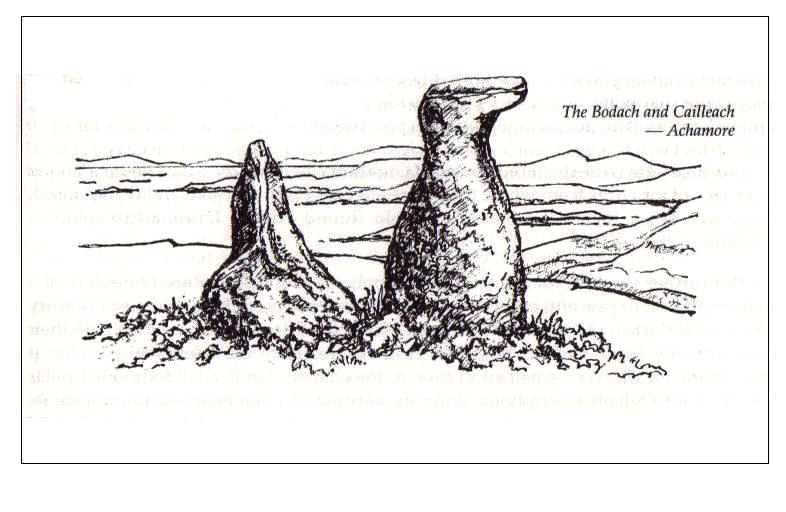
The Bodach and Cailleach, Gigha, Argyll

Sacred Stones:  OS Grid Reference – NR 6382 4730

Folklore

The Bodach and the Cailleach
The Bodach & the Cailleach

On this “Isle of the Gods” — as some historians proclaim Gigha to mean — the ancient rites and ceremonies of local folk continued until pretty recent times.  One writer narrated some intriguing pre-christian events connected to this curious and little-known place, speaking of indigenous heathen rites:

“These are in fact known to have persisted on the island until well into the early part of the (19th) century when Irish fishermen could still be seen climbing the little hill of Moinean Sitheil, in the sacred Moss of Peace below Ardminish, to pay homage to the “Old Ones” of Gigha: a pair of ancient legend-shrouded stones known as the Bodach and the Cailleach, that from time immemorial have stood upon a low green knoll below the farm of Achamore.

“Through the countless ages the strange jug-headed little Bodach and his smaller consort have kept steadfast vigil over Gigha: their mysterious aura said to guarantee its continuing fertility and prosperity as they link the thriving island of today with beliefs and traditions having roots in the earth-cults and sun-worship of primeval times.  In the past folk would have honoured them with offerings of meal or milk and even now they still command considerable local affectation and respect, albeit expressed in less overtly pagan ways.  And so they stand as ever upon their tiny hillock gazing out across tumbling terraces of old Cantereoch and beautiful Ardlamey Bay, inscrutable and silent, yet with a strangely ‘knowing’ air impossible to define.”

References:

  1. Anonymous, Exploring Historic Kintyre and the Isle of Gigha, Harlequin Press: Oban n.d.

© Paul Bennett, The Northern Antiquarian


Raven’s Stone, Elgol, Strathaird, Skye

Standing Stone (destroyed):  OS Grid Reference – NG 520 144

Folklore

This once-famous standing stone appears to have gone.  It was described in Otta Swire’s (1961:230) superb book on the folklore of Skye, where she wrote:

“Overlooking Elgol is Bidein an Fhithich. Near here once stood the famous Raven’s Stone, about which the Brahn Seer prophesied. It is believed that this prophecy, however, can never be fulfilled, as seventy or eighty years ago the stone was broken up and the main portion of it is now incorporated in one wall of the Glendale church, according to the Rev. A. R. Forbes’ Place Names of Skye. The stone was believed to have had some connexion with old pagan religious ceremonies.”

The Brahn Seer (more commonly known as the Brahan Seer) was Coinneach Odhar, a 16th century prophet who is said to have foretold the Battle of Culloden and other events.

References:

Swire, Otta F., Skye: The Island and its Legends, Blackie & Sons: Glasgow 1961.

© Paul Bennett, The Northern Antiquarian

Kilmarie, Kirkibost, Strathaird, Skye

Stone Circle (destroyed):  OS Grid Reference – NG 552  172

Also Known as:

  1. Cille Mhaire

Folklore

Omitted from Burl’s (2000) magnum opus, the great Scottish folklorists Otta Swire (1961) is the singular reference to the forgotten stone circle that once existed here.  She wrote:

“The site of the old church of Kilmarie and of the stone circle whose proximity no doubt originally called it into being are now no longer to be seen. The ruins of the old church, I am told, were swept away by the sea during that great storm in the 1920s which also blew down the Dunvegan woods.  The storm followed not long after the burial near the old church of an unknown sailor taken from the sea, and there were those who believed this to be the cause of the church’s disappearance, for, as the old Gaelic rhyme says: “The sea will search the four russet divisions of the universe to find her children,” and Kenneth MacLeod advises that a body taken from the sea should always be buried near the water’s edge, or the sea, desiring to recover her own, will flood much land in search of it.

“This church is said to have stood on the site of an older church of St. Maelrhuba (Servant of Peace) who was the patron saint of south-eastern Skye.”

References:

  1. Burl, Aubrey, The Stone Circles of Britain, Ireland and Brittany, Yale University Press 2000.
  2. Swire, Otta F., Skye: The Island and its Legends, Blackie & Son: Glasgow 1961.

© Paul Bennett, The Northern Antiquarian 
Dun Bhuirg, Iona, Argyll

Hillfort:  OS Grid Reference – NM 2649 2462

Also known as:

  1. Canmore ID 21638
  2. Dun Cul Bhuirg

Getting Here

Take the road that cuts across the island, west, until you reach the stupid golf-course.  Walk across it, heading for the coast (not the building at Culbuirg), then follow the little footpath up until you reach the large rocky rise about 500 hundred yards north.  That’s it!

Folklore

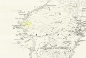
Dun Bhuirg on 1881 map

Shown on the 1881 OS map of the region, the small remains of this Iron Age hillfort was said to be the place where St. Columba saw a rain-cloud which he predicted would bring a plague of ulcers to the people of Ireland. To prevent such a plague, Columba thence dispatched a monk called Silnan to Ireland, armed with some bread which he’d blessed. This bread was then dipped in consecrated water and given to those afflicted with the plague, who were thereafter cured.

Wee-ird……

Another tradition told that this old fort was once an important meeting place for the druids, though Geoff Holder (2007) writes that this is little more than a “spurious nineteenth century tradition” which he dismisses as without foundation. Though a short distance from here, he also told how one “Fiona MacLeod” (real name, William Sharp) one night watched the ghost of the Culdee, Oran, a couple of hundred yards away, “and so he never went that way again at night.”  In truth, traditions of druidism tend to be animistic traits: legends remembered from pre-christian days, and blanket dismissals of such folklore are themselves untrustworthy—especially on this Isle of the Druids.

References:

  1. Holder, Geoff,The Guide to Mysterious Iona and Staffa, Tempus: Stroud 2007.
  2. MacLeod, Fiona, Iona, Floris: Edinburgh 1982.

© Paul Bennett, The Northern Antiquarian

Tobar na H-aoise, Iona, Argyll

Holy Well: OS Grid Reference – NM 2839 2525

Also Known as:

  1. Canmore ID 21613
  2. Pool of Healing
  3. Well of Age
  4. Well of Healing

Folklore

Although ascribed as a holy or healing well, this site is actually a curious natural water-filled depression near the top of Dun I, on the northern side of the island.  It is one of three magickal wells to be found hereby.  F.M. McNeill (1954) described this Well of Eternal Youth as having a fame that had spread far and wide, saying,

“Here, through ages past, pilgrims of each generation have lingered at the enchanted hour of dawn, ‘to touch the healing water the moment the first sun-ray quickens it.'”

In doing so, devotees would recover the energies of youth once more and live a longer healthy life.

References:

  1. Hannan, Thomas, Iona and some Satellites, W. & R. Chambers: London 1928.
  2. McNeill, F. Marion, Iona, Blackie & Sons: Glasgow 1954.

© Paul Bennett, The Northern Antiquarian

Na Clachan Bhreige, Kirkibost, Strathaird, Skye

Stone Circle:  OS Grid Reference –  NG 5432 1768

Also known as:

  1. The False Stones
  2. Na Clachan Breitheach
  3. Strathaird Circle

Getting Here

Way off from seemingly anywhere this one – on the southern foothills of the great Cuillins, by the western edge of a seemingly unnamed loch. (most unusual) Take the Elgol road (A881) south from Broadford, nearly to its end, keeping an eye out for Kirkibost a few miles from the very end of the road. Just past here, stop and walk the track west to Camasunary a half-mile along, through the small forestry-bit, then follow the line of the trees north and keep going a bit more till y’ reach the nice stream that feeds that unnamed loch. Cross the stream!

Archaeology & History

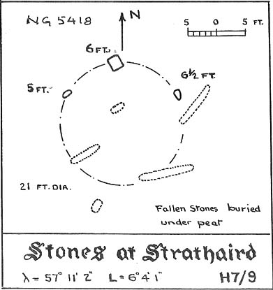
Alexander Thom's 1967 drawing
Alexander Thom’s 1967 drawing

A fascinating little site this one! Perhaps consisting of as many as eight stones at one time, only three stand visible today.  Alexander Thom (1967) reported finding other stones in this circle “being buried in the peat, but prodding revealed their position roughly” — as shown on his drawing here.  There may at one time have been as many as eight stones here, but the site itself is quite small, making a ring of stones only 21-feet across (or 8 megalithic yards as Thom had it).  The ruinous state of the site was put down to the stupidity of the Church of Scotland issuing “instructions that all stones in Skye were to be thrown down” a few centuries back.

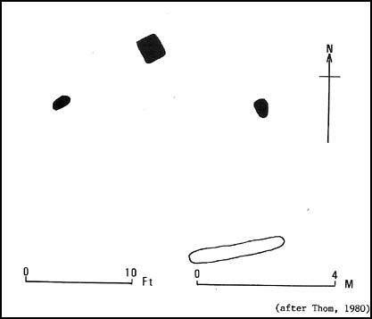
Aubrey Burl's later 'four-poster' summary
Aubrey Burl’s later ‘four-poster’ summary

Aubrey Burl reported that “there were once at least 4 stones here, the tallest being of 6ft 6ins (2m) high,” and wondered whether this was one of the many ‘four-poster’ stone circles that scatter Scotland and elsewhere.  An issue he seemed comfortable to proclaim a few years later in his survey of such sites. (Burl 1988) Of those stones still standing, the tallest is just 5 feet high; but there’s the impressive 11½-foot long monolith laying on the southeast edge of the ring!  Mr Burl also pointed out that some

“casual digging  inside the ring around 1860 uncovered a blackpolished stone about 1½ ins (4cm) long, ‘somewhat resembling a small pestle.'”

I found the proximity of the Cille Mhaire burial ground a mile west of here more than a bit intriguing (though didn’t have time to assess its geomantic relationship further).  And the reported presence of prehistoric cairns nearby imply that the Na Clachan Bhreige ‘circle’ had some relationship with death and burial.

Folklore

The folkname of ‘The False Stones’ comes from that well-known tale of the site “supposedly being the remains of three men turned into stone for deserting their wives.”  Something which Otta Swire (1964) thought was likely told by christian converts.  It would have probably replaced an earlier tale of the stones being the site where some ancestral spirits lived.  Swire also told that,

“these were once, if tradition is to be believed, Stones of Wisdom who could both foretell the future and show justice as between man and man.”

Burl (1988) also points out how,

“The name, Na Clachan Bhreige, has been variously pointed translated as ‘the judicial stones’, a place where medieval law courts were held, as in several other Scottish rings.  It has also been interpreted as ‘the stone of lies, or falsehood.'”

References:

  1. Burl, Aubrey, Four Posters: Bronze Age Stone Circles of Western Europe, BAR: Oxford 1988.
  2. Grinsell, L.V., Folklore of Prehistoric Sites in Britain, Hale: Newton Abbot 1976.
  3. Swire, Otta F., Skye: The Island and its Legends, Blackie & Sons: Glasgow 1961.
  4. Thom, Alexander, Megalithic Sites in Britain, Oxford University Press 1967.
  5. Thom, A., Thom, A.S. & Burl, Aubrey, Megalithic Rings, BAR: Oxford 1980.

© Paul Bennett, The Northern Antiquarian