Cowcliffe Cross, Fartown, Huddersfield, West Yorkshire

Cross:  OS Grid Reference – SE 13949 18935
Getting Here

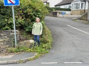
Lizzi by the cross-base

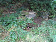
Nice ‘n easy: from Huddersfield central, take the A641 road north to Brighouse, but barely a half-mile out of town turn left up the Halifax Old Road.  Go on here for nearly a mile, then keep your eyes peeled for the aptly-named South Cross Road on your right.  Go up here all the way to the end where it meets with Cowcliffe Hill Road.  Here, at the junction, right by the roadside at the edge of the wall, is the remains of the old cross-base, all but covered in vegetation.  You’ll see it.

Archaeology & History

The little-known remains of a post-medieval cross base can still be seen, albeit very overgrown, right by the roadside.  The upstanding stone cross that once stood upon it has long since gone (perhaps broken up and built into the wall).  It may have been one of two such crosses relatively close to each other: as this one is found at South Cross Road, there may have been another one at the nearby North Cross Road, but history seems to be silent on the matter.
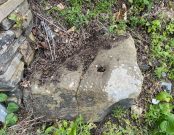
Top of the cross-base

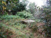
The cross-base itself has several holes cut into it where the standing stone cross was fixed upright.  Very little seems to be known about this monument.  George Redmonds (2008) told simply that, “the base of a cross survives on Cowcliffe Hill Road, no doubt marking the ancient crossroads. It explains the names North and South Cross Roads.”  He added that, “The base of the cross survives, partly hidden in the undergrowth, and it is the only visible evidence we have of several similar crosses in the township.”

References:

  1. Redmonds, George, Place-Names of Huddersfield, GR Books: Huddersfield 2008.

Acknowledgements:  Huge thanks to Liz Sykes for helping out big-time to uncover the base from beneath the mass of herbage.

© Paul BennettThe Northern Antiquarian

Holy Well, Huddersfield, West Yorkshire

Holy Well:  OS Grid Reference – SE 12134 15643

Getting Here

Holy Well, full of trash

There are various ways to find this.  When we came here, we started from the Barton and Crosland Moor side, parking up on Ivy Street and walking to the fields at the  end of the road.  From here, walk along the track to your left and just over 100 yards on there’s a small footpath on your right that veers down the slope.  Walk on here for another 100 yards, keeping your eyes peeled for another path on your right that almost doubles-back on you, heading into the trees.  Another fifty yards along and you’ll see some tell-tale stonework!

Archaeology & History

An earlier, adjacent water trough?

Highlighted on the 1854 OS-map, the site has seen better days.  Although the waters today emerge from a blasted rock face and collect into a relatively modern round stone trough, there is a larger square stone structure just a few yards away that seems to have been where water was previously collected.  According to local antiquarian Andy H, this was known to be a local Wishing Well in bygone times, but apart from this there are no literary accounts about the place.  The area was decimated by 19th century Industrialists who, as is well known, destroyed much of our indigenous histories and sites—and the Huddersfield district was particularly hard hit by them.

On a recent visit to the site—in superb pouring rain!—the waters were choked with modern trash and bottles, making it unsafe to drink.  This is surely a good case for renovation, then stuck on some local tourist route to ensure better, more appreciative attention.

Links:

  1. South Crosland Holy Well on The Megalithic Portal

© Paul BennettThe Northern Antiquarian

All Saints Church, Almondbury, West Yorkshire

Tumulus (destroyed):  OS Grid Reference – SE 1676 1504

Archaeology & History

The only thing we know of this long lost site comes from a tradition narrated by the Canon Hulbert (1882) in his definitive history of Almondbury parish.  High up the hill near the very top of the village where All Saints Church was built, he told how tradition said,

“that a tumulus or mound existed at the west end where now the Clerk’s house stands; which may have been an ancient British site and led to the erection of the church.”

Sadly, there seems to be no further information about the site.

References:

  1. Hulbert, Charles A., Annals of the Church and Parish of Almondbury, Longmans: London 1882.

© Paul Bennett, The Northern Antiquarian

Rocking Stone, Golcar, West Yorkshire

Legendary Rock (destroyed):  OS Grid Reference – SE 076 163

Also Known as:

  1. Holed Stone
  2. Holy Stone
  3. Whole Stone

Archaeology & History

Golcar rocking stone in 1799

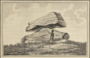
Like many old rocking stones, this was destroyed due to quarrying operations many years ago and sadly, I believe, we have no illustrations of the place to show the site.  This legendary site—also known as the ‘Holed’ or ‘Holy Stone’—is preserved in the place-name of Rocking Stone Hill and, unlike many other alleged rocking stones, actually swayed to and fro if the old records are owt to go by.  Not far away (and also destroyed some 200 years back) were two stone circles which probably had some mythic relationship to this legendary rock.

The stone was first described by John Watson in his monumental History of Halifax (1775), where he told that is was,

“so situated as to be a boundary mark, dividing the two townships of Golcar and Slaightwait in the Parish of Huddersfield, adjoining to the Parish of Halifax on Wholestone Moor.  The stone as measured by the late Thomas Perceval, or Royton…is 10½ feet long, 9ft 4in or 5in broad, and 5ft 3in thick.  Its weight…is 18 tons, 190lbs.  It rests on so small a centre, that at one particular point, a man may cause it to rock; though some years ago it was damaged a little, in this respect, by some masons, who endeavoured, but in vain, to throw it off its centre, in order to discover the principle on which so large a weight was made to move.”

Mr John Crabtree (1836) included it in his survey, and it was illustrated on the very first Ordnance Survey map in the 1840s where it was described as ‘Supposed Druidical’.  But the old stone sadly didn’t last much longer.  Once the self-righteous Industrialists got here, round about the year 1886, the Rocking Stone was destroyed by quarrying operations.  All that remains of the place today is a small cluster of place-names..

Folklore

Thought by Watson (1775) and his contemporaries to have had druidic associations (without evidence), when Philip Ahier (1942) came exploring this area in 1936, he came upon “an old resident (who) informed me that he had sat upon the stone when a youth and had caused it to rock.”

References:

  1. Ahier, Philip, The Legends and Traditions of Huddersfield and District, Advertiser Press: Huddersfield 1942.
  2. Bennett, Paul, The Old Stones of Elmet, Capall Bann: Milverton 2001.
  3. Crabtree, John, Concise History of the Parish & Vicarage of Halifax, Hartley & Walker: Halifax 1836.
  4. Watson, John, The History and Antiquities of the Parish of Halifax, T. Lowndes: London 1775.

© Paul Bennett, The Northern Antiquarian 


Slaithwaite Cross, West Yorkshire

Cross:  OS Grid Reference – SE 077 139?

Archaeology & History

The great Huddersfield historian, Philip Ahier (1948), in describing the lack of documentary evidence for several crosses in the neighbouring region, “at Deighton, Cowcliffe, Marsh and Golcar,” found out that,

“One did exist at Slaithwaite in front of the Manor House in the early past of the last century.  In March 1931, the base of this cross, commonly known as the Dial Stone, was removed to Doughlas in the Isle of Man, where it rested in the garden of Mr Harry Wood; in August 1939, it was brought back to Slaithwaite and now stands in the Recreation Park.”

However, this site differs from another two that I’ve found records for on the outskirts of this township.  Does anyone know what became of this old stone cross?  Izzit still about?  Its folk-name of the Dial Stone may make it a little easier to locate — but at the same time it does bring up the query, Why was it called that?

References:

  1. Ahier, Philip, The Story of the Three Parish Churches of St. Peter the Apostle, Huddersfield – volume 1, Advertiser Press: Huddersfield 1948.

© Paul Bennett, The Northern Antiquarian 


Hagg Woods, Thongsbridge, Holmfirth, West Yorkshire

Cairns:  OS Grid Reference – SE 1493 1026

Getting Here

Take the A6024 road south out of Huddersfield for about 4 miles, past the turnings to Honley, and when you reach a section where the road runs through a nice bitta woodland, stop! Go into the woods on the western side of the road near the bottom end where a footpath runs up to Haggs Farm. The cairnfield is about 100 yards up into the woods, evidenced by small overgrown heaps in a small cluster.  Good luck!

Archaeology & History

These are pretty difficult to locate even when the vegetation isn’t covering them!  But if you’re diligent and enjoy a good foray in searching for archaeological remains, you might uncover summat.  For here are the scattered remains of what was once a group of seven cairns with adjacent ring-banks, last excavated in the early 1960s by Neil Lunn and other members of the Huddersfield & District Archaeology Society.  Little by way of datable material was found, although one of them did “reveal features typical of some Bronze Age barrows.” Beneath this one they found “the remains of a hut or shelter with a succession of small hearths and a group of stone-packed postholes.”

It would be nice to find out the precise status of this area as few other remains seem in evidence, which can’t be right surely?

References:

  1. Barnes, B., Man and the Changing Landscape, University of Liverpool 1982.
  2. Lunn, N., ‘Account of Recent Fieldwork in the Honley Area,’ Hudds Dist. Archaeo. Soc., 13, 1963.

© Paul Bennett, The Northern Antiquarian