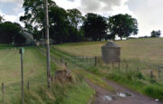
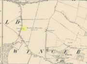
Mullach-Geal Stone, St Kilda, Outer Hebrides

Legendary Rock:  OS Grid Reference – NF 092 996

Archaeology & History

This is a most intriguing site, whose exact location seems to have been forgotten.  It was first mentioned in Macaulay’s History of St Kilda (1764) as being one of four stone altars that the islanders used for worship.  Three of them were related to the early christian figure of St. Brendan, whose well and chapel remains are on the south-side of the island.  However, this fourth stone altar possessed a purely magickal and heathen function.  Macaulay initially gives the location as being “on top of a hill to the southwest” of St. Brendan’s chapel; but subsequently tells us it was upon “Mulach-geall” which is a mile NNW.  It was an important place to the people of Hirta and its exact position needs to be found and, hopefully, the altar still exists.

Folklore

Despite Macaulay’s conflicting directions of how to get here (a common feature of early writers), he wrote:

“I have already made mention of one St. Kilda altar, that in Brendans Chapel.  There are no less than four more in the island, of which three lie at considerable distances from the holy places.  There is one particularly on the top of a hill to the south-weft (sic), dedicated according to tradition to the God who presides over Seasons; The God of thunder, lightning, tempests and fair weather.  To avert the terrible judgments inflicted by this mighty Divinity, the ancient St. Kildians offered propitiatory sacrifices on this altar, sacrifices of different forts, much like the old Pagans, who offered a black sheep to Winter, or the Tempest, and a white one to the Spring…  The place where the people of this island, offered their victims to Taranis, is called Mulach-geall, that is to say, the White eminence or hill…”

More than a hundred years later, Seton (1878) made mention of it, but added no further details.

The invocation to Nature’s elements is something we find echoed at some sites further east, such as the Well of the North Wind on Iona and its compatriot Well of the South Wind.  At both these places, so-called ‘pagan’ rituals were used to both placate and invoke the gods and spirits of the wind.  This one on St Kilda possessed additional magickal prowess.  But where is it?  Have we lost it, or is it sleeping somewhere on the edge of Mullach-Geal…?

References:

  1. Macaulay, Kenneth, The History of St. Kilda; Containing a Description of This Remarkable Island; the Manners and Customs of the Inhabitants; the Religious and Pagan Antiquities There Found, T. Becket: London 1764.
  2. Seton, Gordon, St. Kilda – Past and Present, William Blackwood: Edinburgh 1878.

© Paul BennettThe Northern Antiquarian

Redman’s Spa, Bingley Moor, West Yorkshire

Healing Well:  OS Grid Reference – SE 1159 4343

Also Known as:

  1. Redmire Spa
  2. Redmond’s Spa
  3. Richmond’s Spa

Getting Here

Redman’s Spa on 1851 map

From East Morton village, take the moorland road, east, and up the steep hill.  Where the road just about levels out there’s a right turn, plus (more importantly!) a trackway on your left which leads onto the moor.  Walk up this track for ⅔-mile until you get to the point where the moorland footpath splits, with one bending downhill to an old building, whilst the other smaller footpath continues on the flat to the north.  Go up here for 400 yards then walk off-path, right, for about about 150 yards.  But beware – it’s boggy as fuck!

Archaeology & History

On this featureless southern-side of Rombalds Moor, all but lost and hidden in the scraggle of rashies, a very boggy spring emerges somewhere hereabouts.  I say hereabouts, as the ground beneath you (if you can call it that!) is but a shallow swamp and its actual source is almost impossible to locate.  If you want to find the exact spot yourself, be prepared to put up with that familiar stench of bog-water that assaults our senses when we walk through this sort of terrain.  Few are those who do, I have found… But somewhere here, amidst this bog—and still shown on the OS-maps—is the opening of what is alternatively called Redman’s or Richmond’s Spa.  We don’t know exactly when it acquired its status as a spa-well, but the 18th century Halifax doctor, Thomas Garnett—who wrote the early work on the Horley Green Spa—appears to be the first person to describe it.  Garnett (1790) said how the place:

“was first mentioned to me by Mr W. Maud, surgeon, in Bradford, who went with me to see it.  It is situated on Romalds-moor, about two or three miles from Bingley, and goes by the name of Redmire-spaw.  The access to it is by no means good; the ground about it being very spongy and soft.  On the bottom and sides of the channel is deposited an ochrey matter, of a very fine, bright, yellow colour; and which I believe is used, by the country people in the neighbourhood, to paint their houses.  It sparkles when poured into a glass and has a taste very like the Tewit-well at High-Harrogate; which water it very much resembles in all its properties, and seems to be about the same strength… This water seems to hold a quantity of iron dissolved by means of fixed air.  Its taste is very pleasant; it is said to act very powerfully as a diuretic, when drank in considerable quantity, and may prove a useful remedy, in cases where good effects may be expected from chalybeates in very small doses; the fixed air, and even the pure water itself may be useful in some cases.  It is, however, necessary to drink it at the well, for it seems to lose its iron and fixed air very soon.”

I’ve drank this water, and believe me!—it doesn’t quite taste as pleasant as Mr Garnett espouses!  Its alright I s’ppose—but drinking water from a bog isn’t necessarily a good idea.  That aside, I find it intriguing to hear so much lore about such a little-known spring; and it is obvious that the reputation Garnett describes about this spa came almost entirely from the local people, who would have been visiting this site for countless centuries and who would know well its repute. Below the source of the well the land is known as Spa Flat, and slightly further away Spa Foot, where annual gatherings were once held at certain times of the year to celebrate the flowing of the waters.  Such social annual gatherings suggests that the waters here were known about before it acquired its status as a spa—which would make sense.  The remoteness of this water source to attract wealthy visitors (a prime function of Spa Wells) wouldn’t succeed and even when Garnett visited the place, he said how he had to travel a long distance to get here.

The origin of its name was pondered by the great Harry Speight (1898) who wondered if it derived from the ancient and knightly Redman family of Harewood, whose lands reached over here.  But he was unsure and it was merely a thought.  As an iron-bearing spring (a chalybeate) you’d think it might derive from being simply a red mire or bog (much like the Red Mire Well at Hebden Bridge), but its variant titles of apparent surnames casts doubt on this simple solution.

No one visits the place anymore.  Of the countless times I’ve wandered the moors, rare have been the times when I’ve seen folk anywhere near this old spring.  It is still coloured with the same virtues that Garnett described in the 18th century: the yellowish deposits, the boggy ground, much of which reaches to the truly dodgy Yellow Bog a short distance north and which should be completed avoided by ramblers after heavy rains (try it if y’ don’t believe me—but you’ve been warned!).

References:

  1. Garnett, Thomas, Experiments and Observations on the Horley-Green Spaw, near Halifax, George Nicholson: Bradford 1790.
  2. Short, Thomas, The Natural, Experimental and Medicinal History of the Mineral Waters of Derbyshire, Lincolnshire and Yorkshire, privately printed: London 1724.
  3. Speight, Harry, Chronicles and Stories of Old Bingley, Elliott Stock: London 1898.

© Paul BennettThe Northern Antiquarian


Robin Hood’s Oak, Great Horkesley, Essex

Legendary Tree (lost):  OS Grid Reference –TL 96 28

Archaeology & History

In more than twenty volumes about Robin Hood in the Northern Antiquarian library, no mention can be found of this all-but-forgotten site, first recorded (I think) in September 1637, in the boundary perambulation account of northern Colchester.  In days of olde, folk walked the boundaries annually and so the description given here follows their very footsteps – although the landscape has obviously been altered in places since then.  Because of the length of the entire perambulation their account is rather long, so I’ve cut to the piece relating to our legendary oak tree, which gives a good idea of its location.  We meet up with them at a place called Motts-Bridge, just above a place that is today called Seven Arches Farm (TL 9630 2595):

“…and so over Mott’s-bridge, and so cross the river by Nicholas Ayleward’s howse into the meadowe crossinge over to the lower ende of West-fielde, and from thence to Buttolph’s brooke leavinge the Brooke alwais upon the left-hand, and so along to Thomas Abrige (which is righte against Robin Hood’s oake). And from thence to Black-brooke under Chesterwelle and so along the Rampiers by Horkesley Heathe to the brooke that is under Langham-park-corner…”

P.H. Reaney (1935) proposes that the ‘Rampiers’ in this account is the Iron Age hillfort of Pitchbury Ramparts.

The description of its whereabouts isn’t too clear, but in a subsequent and much longer perambulation account from August 1671, some extra topographical features are mentioned.  Starting not far from Mott’s Bridge, down Shett’s Hill to Newbridge,

“and then into the Fields in the occupation of Matth. Ayleward…through a gate a little above the Bridg: and soe along to Matth. Ayleward’s Yard, crosse the River into Matth. Ayleward’s Meadowe, and crosse that Meadowe into the lower part of Westfields, neare to which is a Foote-bridge cross the river, which is called Mott’s-bridge.  And soe along through West-fields to a Gate in a lane at or neere the north ende of a Meadow of one Mrs —, now in Samuel Duglet’s occupation, which lane parts West-fields from Bergholt, as the Parsons of each Parish, whoe were both present, affirmed; and, upon a Tree standing neere to which Gate is set a crosse.  And from thence to Butolph’s brooke, leaveing the brooke allwaies  upon the left-hand; and soe along through Mr Leming’s Meadows and Woods at the ende of them to a Bridge called Thomas Abridge, leading on to Horkesley Heath, which bridge is right against Robin Hood’s Oake, that stood on the pitch of the hill. And from thence along the Naylande Roade over Horkesley-heathe to Blackbrooke under Chesterwell, which Brooke runnes crosse the way at the foote of Horkesly cawsy…”

This second account seems to speak of the tree in the past tense, telling us that “Robin Hood’s Oake, that stood on the pitch of the hill”, but we can’t be completely sure.  I presume that there’s no longer any trace of this legendary oak tree; however, considering the fact that oaks can live to an incredible age, it may be worthwhile for a local antiquarian to follow this ancient boundary and see if, perchance, any remaining tree stump might still be there.  Y’ just never know…..

There are several other place-names in Essex relating to our mythical outlaw, including Robinhood End at Finchingfield described in 1699, and a farm of the same name nearby; plus a Robin Hood’s Inn near Loughton. (Reaney 1935)  There are probably a few more hiding away in field-name records…

NB:  The grid-reference map linked to this site is an approximation.  If someone can find the exact spot where the tree stood, we’ll update its position.   

References:

  1. Morant, Philip, The History and Antiquities of the Most Ancient Town and Borough of Colchester, W. Bowyer: London 1748.
  2. Reaney, P.H., The Place-Names of Essex, Cambridge University Press 1935.

© Paul BennettThe Northern Antiquarian

Pitchbury Ramparts, Great Horkesley, Essex

Hillfort:  OS Grid Reference – TL 9657 2906

Also Known as:

  1. Pitchbury Rings

Getting Here

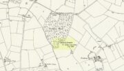
Pitchbury site on 1924 map

Along the A134 in Horkesley Heath, turn west along Coach Road and after a half-mile where it veers right, keep going for another half-mile where you’ll reach the woodland on your left.  A path goes into the trees just before Pitchbury Lodge.  Go along here and near the very far (southern) end of the trees, just before the open fields, you’ll see the large undulating ramparts of earth.  Keep your eyes peeled.  You’ll see them!

Archaeology & History

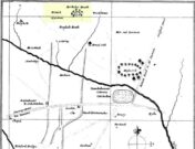
Stukeley’s 1759 map

This once large hillfort was described in the Colchester township perambulations of 1671 and cited in Philip Morant’s classic work. (1748) He told how the boundary line ran “under Chesterwell along the Rampiers by Horkesley Heath,” and which P.H. Reaney (1935) tells was our wooded hillfort.  In Morant’s day, the place was all but complete and so would have been well recognised by local people.   Certainly it came the attention of the great antiquarian William Stukeley who, in 1759, came to Colchester and met with Morant.  Stukeley mainly surveyed the area south of here, at Lexden Heath, but one of his sketch maps clearly highlighted a place he called “a circular work on Horkesley Heath”, i.e., Pitchbury Rings.  The site seems to have remained relatively intact until the middle of the 19th century when a local land-owner took it upon himself to plough over and vandalise much of the site, leaving only a small proportion of the earthworks that we can still see to this day.

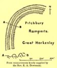
The ruins were described in I.C. Gould’s (1903) piece for the Victoria County History, where he told, at Great Horkesley,

Gould’s 1903 sketch of the remains
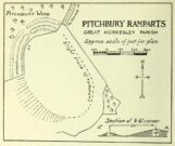
Royal Commission’s 1923 ground-plan

“are some remains of an earthwork known as ‘Pitchbury’ or ‘Pitsbury Ramparts.’  When the late Rev. Henry Jenkins described the camp in 1841, he stated that it was of oval shape, and contained about 6 acres.  Most of it was levelled for agricultural operations about fifty years ago, but there are still some remains, consisting of two banks with their accompanying ditches.  The lines moreover of that part which was destroyed, can be partially traced in the adjoining fields.”

When the Royal Commission (1922) doods wrote about the site nearly twenty years later, things hadn’t changed too much and they simply reported how the “ramparts have nearly disappeared, except for the north section.”  In this “imperfect” condition, as they called it, they gave the following brief description:

“Pitchbury Ramparts, in Pitchbury Wood, about 2 mile south of the church, are the north end of a large camp, roughly oval in shape, and defended by a double rampart and ditch.  The defences are well preserved in the wood, the inner rampart being 10 ft. above the ditch, which is 60ft wide from crest to crest, but the greater part of the work has been almost obliterated by the plough, and is now only faintly discernible in a large field S. of the wood.  The camp appears to have been 800 ft. long and 600 ft. wide.”

Thankfully there seems to have been no real increase in damage to the site since then.  It was excavated in some detail in 1933 and again in 1973 and the finds were published by the highly reputable Colchester Archaeological Trust, whose subsequent report by Hawkes & Crummy (1995) is required reading for anyone wanting to know the detailed archaeology of this and other sites in the area.

Folklore

An intriguing piece of folklore was described in John Round’s (1882) history of the early battles around Colchester Castle.  During the time when the Roman Empire was starting to crumble, the great Pictish tribes of Scotland ventured here and, we are told, took control of the Pitchbury Rings where they stayed before attacking Colchester Castle.

“Traces have been discovered of some violent catastrophe, possibly the first capture of the Colony by the marauding Picts from the North.  Allured, in one of their Southern raids, by the wealth of the goodly Colony, they swooped down like eagles on their quarry from the wooded heights of ‘Pictsbury’.”

References:

  1. Gould, I. Chalkley, “Ancient Earthworks“, in Victoria History of the County of Essex – volume 1, Archibald Constable: Westminster 1903.
  2. Hawkes, C.F.C. & Crummy, Philip, Colchester Archaeological Report 11 – Camulodunum 2, Colchester Archaeological Trust 1995.
  3. Hogg, A.H.A., British Hill-forts – An Index, BAR: Oxford 1979.
  4. Kemble, James, Prehistoric and Roman Essex, History Press: Stroud 2009.
  5. Morant, Philip, The History and Antiquities of the Most Ancient Town and Borough of Colchester, W. Bowyer: London 1748.
  6. Round, John H., The History and Antiquities of Colchester Castle, Benham 1882.
  7. Royal Commission Ancient Historical Monuments, England, An Inventory of Historical Monuments in Essex – volume 3, HMSO: London 1922.
  8. Reaney, P.H., The Place-Names of Essex, Cambridge University Press 1935.
  9. Watson, J.Y., Sketches of Ancient Colchester, Benham & Harrison: Colchester 1879.

Acknowledgements:  Big thanks for use of the 1st edition OS-map in this site profile, Reproduced with the kind permission of the National Library of Scotland

© Paul BennettThe Northern Antiquarian


Holy Well, Holwell, Hertfordshire

Holy Well (lost):  OS Grid Reference – TL 16 33

Archaeology & History

The exact location of this site seems to have been lost.  One possible candidate is on the south-side of the village where remains of a large moat exists, meaning that there was a good water supply here to maintain its existence.  But this is pure guesswork on my part.  The well was mentioned briefly in R.C. Hope’s (1893) classic book where he told us:

“There was a holy well or spring in the village of Holwell, on the borders of Bedford and Hertfordshire; unfortunately both history and site have been forgotten by the villagers at Holywell.”

The site was mentioned as far back as 1086 CE in the Domesday Book as ‘Holewelle’.  The place-name authorities Gover, Mawer & Stenton (1938) tell us this derives from a “spring in the hollow” and not a holy well as subsequent writers profess.  The only thing that could perhaps fortify the ‘holy’ element is that in some instances early citations of holy wells are written as holi- wells, which this may have been.  As all historians know, early spellings of sites are far from accurate.

References:

  1. Gover, J.E.B., Mawer, Allen & Stenton, F.M., The Place-Names of Hertfordshire, Cambridge University Press 1938.
  2. Hope, Robert Charles, Legendary Lore of the Holy Wells of England, Elliott Stock: London 1893.
  3. Smith, A.H., English Place-Name Elements – volume 1, Cambridge University Press 1956.

© Paul BennettThe Northern Antiquarian


All Saints Church, Almondbury, West Yorkshire

Tumulus (destroyed):  OS Grid Reference – SE 1676 1504

Archaeology & History

The only thing we know of this long lost site comes from a tradition narrated by the Canon Hulbert (1882) in his definitive history of Almondbury parish.  High up the hill near the very top of the village where All Saints Church was built, he told how tradition said,

“that a tumulus or mound existed at the west end where now the Clerk’s house stands; which may have been an ancient British site and led to the erection of the church.”

Sadly, there seems to be no further information about the site.

References:

  1. Hulbert, Charles A., Annals of the Church and Parish of Almondbury, Longmans: London 1882.

© Paul Bennett, The Northern Antiquarian
Bishop’s Well, Tottenham, Middlesex

Holy Well (destroyed):  OS Grid Reference – TQ 332 911

Also Known as:

  1. My Lady’s Hole

Archaeology & History

Long since gone after drainage operations on Tottenham Cemetery made the waters dry-up, this was one of several holy wells in the Tottenham area.  Its history has been described in various old tomes, but the most definitive is found in William Robinson’s (1840) classic on the parish of Tottenham, when the well was still visible.  He told us:

“There is a spring which issues from the side of a small hillock on the south side of the Moselle, nearly opposite the Vicarage, leading thence to the Church, called Bishop’s Well.  This spring was formerly considered famous for many strange and wonderful cures performed on the diseased by the use of this water.  It has been for some years neglected, but of late the owner of the field in which this well is, had it cleansed, and planted some trees round it, and put up posts and rails to prevent the cattle treading down the sides of it.  It is said that the water of this well never freezes.  In former times this well was in great repute from the purity of its water.  The ladies in the vicinity of it were accustomed to send their servants in the morning and evening for water for their tea, from which circumstance it was for many years known by the name of “My Lady’s Hole.”  The water of this well is not only esteemed for its medicinal qualities, but particularly for curing disorders of the eye.

“There were formerly many other springs about the village, especially one which issued out of the hill on which the Church stands; and another in Spottons Wood otherwise Spottons Grove, on the north side of Lordship Lane, which in the fifteenth century was of considerable notoriety; but none of which have in former times been so much frequented and held in such repute as Bishop’s Well.”

(Please note: the grid-reference for this site is an approximation)

References:

  1. Foord, Alfred Stanley, Springs, Streams and Spas of London: History and Association, T. Fisher Unwin: London 1910.
  2. Hope, Robert Charles, Legendary Lore of the Holy Wells of England, Elliott Stock: London 1893.
  3. Robinson, William, The History and Antiquities of the Parish of Tottenham, Nichols & Sons: London 1840.
  4. Sunderland, Septimus, Old London Spas, Baths and Wells, John Bale: London 1915.
  5. Thornbury, Walter & Walford, Edward, Old and New London – volume 5, Cassell: London 1878.

© Paul BennettThe Northern Antiquarian


Trumpeter’s Well, Strathaven, Lanarkshire

Healing Well:  OS Grid Reference – NS 66014 41685

Also Known as:

  1. Canmore ID 203472

Getting Here

Trumpeters Well on 1864 map

Take the A71 road southwest out of Strathaven as if you’re heading to Kilmarnock.  After 2½ miles (4.1km) you reach the tiny hamlet of Caldermill (be careful or you’ll truly miss it!).  As you go out of the hamlet, on your left there’s a track up to Hillhead Farm with the small but tell-tale signpost saying ‘Trumpeter’s Well’ and the small dome-shaped stone monument in the field is what yer looking for.  If you’re coming from the Kilmarnock side, when you reach the Caldermill sign, it’s in the field immediately to your right.  Y’ can’t really miss it.

Archaeology & History

When the site was surveyed by the Ordnance Survey lads in the 1850s, the water supply had completely run dry.  It was later revived and the nine-foot tall circular stone building built to commemorate its history.  The water apparently now runs within the building, being supplied from Hillhead Farm.

Trumpeters Well, Caldermill

Folklore

The well is said to have gained its name after the local Battle of Drumclog (1679), when one rich Tory known as John Graham of Claverhouse was retreating for fear of his life; and because his own horse had been killed, the coward stole the horse of his young fourteen-year-old trumpeter.  In doing so, the young lad was subsequently killed and his body was thrown down the well.  Tradition also tells that other soldiers were buried in the same field.

References:

  1. Campbell, J. Ramsey, My Ain, My Native Tour – Stra’ven, J.M. Bryson: Strathaven 1943.

© Paul BennettThe Northern Antiquarian

Chellow Heights, Heaton, Bradford, West Yorkshire

Cist (destroyed):  OS Grid Reference – SE 117 353

Archaeology & History

High up in the landscape on the northwestern edges of Bradford, where we now find the Chellow Heights reservoirs, ancient man saw fit to place the remains of their dead.  It’s in a damn good location too, typical of burial sites.  The views to the immediate north are directly at Rombalds Moor where, as we all know, Bronze Age and other prehistoric remains are found in huge numbers.

It was during the construction of the Chellow Heights reservoirs when the site was uncovered.  Twas here, in June 1921, where segments of three urns and,

“an incomplete incense cup, 2 inches high and 3 inches diameter at its base, were found together with partly burnt bones”,

of what were thought to be a young female adult. There are few other details.  The fact that there was no mention of any covering mound, nor mass or stones, strongly implies that neither a tumulus or cairn covered these urns—and neither place-name evidences nor early maps indicate anything to suggest such a monument—so it would be fair to surmise they had been deposited in a stone cist.

References:

  1. Barnes, Bernard, Man and the Changing Landscape, Merseyside County Council 1982.
  2. Longworth, Ian, Collared Urns of the Bronze Age in Great Britain and Ireland, Cambridge University Press 1984.
  3. Rowe, J.H., “An Ancient Burial at Chellow, near Heaton,” in Heaton Review, volume 2, 1928.

© Paul BennettThe Northern Antiquarian

Devil’s Stone, Winceby, Lincolnshire

Legendary Rock (destroyed):  OS Grid Reference – TF 3127 6901

Also Known as:

  1. Big Stone of Slash Lane

Archaeology & History

Stone shown on 1887 map

There is no specific archaeological information about this stone.  However, we must take note of the so-called “devil’s footprint” that was on the boulder.  In some parts of the UK, some devilish and other mythic footprints on stone are prehistoric cup-markings; but we have no idea whether this impression was such a carving or—more probably in this case—Nature’s handiwork.  The field in which the stone existed was said to be the place where the so-called Battle of Winceby occurred.

Folklore

The stone was mentioned in several old tomes, with each one generally repeating the same familiar story, and with motifs that will be familiar to antiquarians and folklorists alike.  In an early edition of Notes & Queries we were told of,

“the large stone in Winceby field, where soldiers had sharpened their swords before the battle. This was a stone of fearful interest, for much treasure was supposed to have been buried under it. Numerous attempts have been made to get at this treasure, but they were always defeated by some accident or piece of bad luck. On the last occasion, by ‘yokkin’ several horses to chains fastened round the stone, they nearly succeeded in pulling it over, when, in his excitement, one of the men uttered an oath, and the devil instantly appeared, and stamped on it with his foot.  “Tha cheans all brok, tha osses fell, an’ tha stoan went back t’ its owd place solidder nur ivver; an’ if ya doan’t believe ya ma goa an’ look fur yer sen, an’ ya’ll see tha divvill’s fut mark like three kraws’ claws, a-top o’ tha stoan.’  It was firmly believed the lane was haunted, and that loud groans were often heard there.”

The tale was retold in Grange & Hudson’s (1891) essay on regional folklore.  In Mr Walter’s (1904) excellent local history survey, there was an additional shape-shifting element to the story which, in more northern climes, is usually attributed to hare; but this was slightly different.  The stone, as we’ve heard,

“was supposed to cover hidden treasure, and various attempts were made at different times to remove it, sometimes with six or even eight horses. At one of these attempts, his Satanic Majesty, having been invoked by the local title of ‘Old Lad’ appeared, it is said, in person, where upon the stone fell back, upsetting the horses.  On another occasion a black mouse, probably the same Being incarnate in another form…ran over the gearing of the horses, with a similar result.  Eventually, as a last resort, to break the spell, the boulder was buried, and now no trace of the boulder, black mouse, or Satan’s foot-print remains.”

Sadly we have no sketches of the devil’s ‘footprint’; and if local lore is right, we’ll never know.  For tis said that a local farmer in the 1970s dug down and removed the stone completely.  All that he found were numerous broken ploughshares around the rock, indicating that many tools had been used to shift the stone.

References:

  1. Grange, Ernest L. & Hudson, J.C. (eds.), Lincolnshire Notes and Queries – volume 2, W.K. Morton: Horncastle 1891.
  2. Gutch, Mrs & Peacock, Mabel, Examples of Printed Folklore Concerning Lincolnshire, David Nutt: London 1908.
  3. Walter, J. Conway, Records, Historical and Antiquarian of Parishes around Horncastle, W.K. Morton: Horncastle 1904.

© Paul BennettThe Northern Antiquarian