St. John’s Well, Berkhamsted, Hertfordshire

Holy Well (destroyed):  OS Grid Reference – SP 9848 0822

Also Known as:

  1. St. James’ Well

Archaeology & History

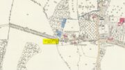
Site shown on 1897 map

Shown on the early Ordnance Survey maps of the town, Berkhamsted’s holy well was a place of some renown in bygone centuries.  Today it is barely remembered.  It was initially dedicated to St. James, as it was associated with a chapel dedicated to that saint close by, but it had a change of name when the legendary Brotherhood of St. John the Baptist became the new caretakers, so to speak.  As a result of this, its history can be a little confusing to some folk!

In the late 12th century, pagan worship at this site came to the attention of Hugh of Grenoble, the Bishop of Lincoln, who visited the place to stop local folk performing their animistic practices (although the exact nature of such rites were not described, sadly).  It didn’t work, obviously; as once the bonkers bishop had gone, local folk would have continued in their old ways, no doubt wondering who the hell the odd incomer had been who was telling them to stop doing what they had always done here at the cost of no one.  And so the waters continued to be used under the mythic cover of old St James—for the time being at least.
The well later became a centre of pilgrimage and and a hospital was been built close by dedicated to St James, where leprosy was treated and the curative waters from this well were used.  St James’ Day was July 25 and an annual fair was held in Berkhamsted thanks to a Royal Charter of James I in 1619.  Hertfordshire traditions relating to St James Day are described in Miss Jones-Baker’s (1974) fine survey on the customs of the county.  But change was a-coming when a local monk had a dream that the waters of this “pagan spring” needed to be blessed and dedicated to the virtues of St. John the Evangelist and a shrine built where pilgrims could worship and be healed.  And as Jones-Baker (1977) told us,

“The water of St John’s Well were thought to cure a variety of diseases; among these leprosy and scrofula (the King’s Evil) as well as sore eyes.  There was also a persistent belief that clothing washed in its waters would impart good health to the wearers.”

In the period when the Protestant Reformation occurred, the well and its immediate surrounds apparently became derelict and overgrown.  The Old Ways returned and local folk began to visit the waters again at night and the animistic rituals that would have been taken to other secret places returned to St. John’s Well.  In this period a local physician, a Dr. Woodhouse, used the sacred waters as part of magickal rites to exorcise evil spirits!

In spite of the local authorities declaring in 1865 that the water was “unfit for drinking”, local folk later told otherwise.  Its waters were still being used in the 20th century and its traditions no doubt retained.  As the local writer Dora Fry (1954) told us:

“The families dwelling in the cottages at the Bulbourne end of the lane, just below St John’s Spring, were all remarkably healthy… Some time after the town got its first waterworks (and) the local authorities declared that the well’s water was to be used only for the gardens… but I remember as a child drinking the water from the main spring and its coolness and freshness were delectable on a hot summer afternoon.”

The well was still visible up until the 1930s, when its waters ran down a shallow channel along St John Well’s Lane, but then a shop was built above the site and the well has been lost forever.

References:

  1. Bord, Janet & Colin, Sacred Waters, Granada: London 1985.
  2. Chauncy, Henry, The Historical Antiquities of Hertfordshire – volume 2, J.M. Mullinger: Bishops Stortford 1826.
  3. Cobb, John W., Two Lectures on the History and Antiquities of Berkhamsted, Nichols & Son: London 1883.
  4. Fry, Dora, “St. John’s Well,” in Hertfordshire Countryside, volume 8, 1954.
  5. Harte, Jeremy, English Holy Wells – volume 2, Heart of Albion press: Wymeswold 2008.
  6. Jones-Baker, Doris, Old Hertfordshire Calendar, Phillimore: London 1974.
  7. Jones-Baker, Doris, The Folklore of Hertfordshire, B.T. Batsford: London 1977.
  8. Page, William (ed.), Victoria History of the County of Hertford – volume 2, Archibald Constable: London 1908.
  9. Salmon, N., The History of HertfordshireDescribing the County and its Monuments, London 1728.

Acknowledgements:  Huge thanks for use of the Ordnance Survey map in this site profile, reproduced with the kind permission of the National Library of Scotland

© Paul BennettThe Northern Antiquarian

Cross Oak, Berkhamsted, Hertfordshire

Sacred Tree:  OS Grid Reference – SP 964 079

Archaeology & History

Location of the Cross Oak, shown on 1883 OS-map

About mile south of Northchurch, on the far side of the A41 dual carriageway, somewhere past the old crossroads (or perhaps even at the crossing) an ancient tree lived—and truly lived in the minds of local people, for perhaps a thousand years or so.  Mentioned in the Lay Subsidy Rolls in 1307, the Cross Oak gave its name to the old building that once stood in the trees and the hill itself, at the place now known as Oak Corner.  Whether or not a “cross” of any form was set up by this old oak, records are silent on the matter.  Its heathen ways however, were pretty renowned! (a plaque should be mounted here)

Folklore

The first reference I’ve found of this place is in William Black’s (1883) folklore survey where he told that “certain oak trees at Berkhampstead, in Hertfordshire, were long famous for the cure of ague”—ague being an intense fever or even malaria. But a few years later when the local historian Henry Nash (1890) wrote about this place, he told that there was only one tree that was renowned for such curative traditions, that being the Cross Oak.  He gave us the longest account of the place, coming from the old tongues who knew of it when they were young—and it had it’s very own ritual which, if abided by, would cure a person of their malady.  “The legend ran thus”, wrote Mr Nash:

“Any one suffering from this disease was to proceed, with the assistance of a friend, to the old oak tree, known as Cross Oak, then to bore a small hole in the said tree, gather up a lock of the patient’s hair and make it fast in the hole with a peg, the patient then to tear himself from the tree, leaving the lock behind, and the disease was to disappear.

“This process was found to be rather a trying one for a weak patient, and by some authority unknown the practice was considerably modified. It was found to be equally efficacious to remove a lock of hair by gentle means, and convey it to the tree and peg it in securely, and with the necessary amount of faith the result was generally satisfactory. This is no mere fiction, as the old tree with its innumerable peg-holes was able to testify. This celebrated tree, like many other celebrities, has vanished, and another occupies its place, but whether it possesses the same healing virtues as its predecessor is doubtful.  It is however a curious coincidence, that the bane and the antidote have passed away together.”

The lore of this magickal tree even found its way into one of J.G. Frazer’s (1933) volumes of The Golden Bough, where he told how the “transference of the malady to the tree was simple but painful.”

Traditions such as this are found in many aboriginal cultures from different parts of the world, where the spirit of the tree (or stone, or well…) will take on the illness of the person for an offering from the afflicted person: basic sympathetic magick, as it’s known.  Our Earth is alive!

References:

  1. Black, William G., Folk Medicine, Folk-lore Society: London 1883.
  2. Frazer, James G., The Scapegoat, MacMillan: London 1933.
  3. Jones-Baker, Doris, The Folklore of Hertfordshire, B.T. Batsford: London 1977.
  4. Nash, Henry, Reminiscences of Berkhamsted, W. Cooper & Nephews: Berkhamsted 1890.

Acknowledgements:  Huge thanks for use of the Ordnance Survey map in this site profile, reproduced with the kind permission of the National Library of Scotland

© Paul BennettThe Northern Antiquarian

Holy Well, Watford, Hertfordshire

Holy Well (destroyed):  OS Grid Reference – TQ 102 952

Archaeology & History

A long lost sacred site (not to be confused with the nearby Bright Well) that has given its name to the district of Holywell.  It also gave its name to an early farmstead; and to the place-name of Holywellane recorded as far back 1485.  It was also described as a “Holy Well” in a local vestry book in 1698.  Nothing more seems to be known of the place.

References:

  1. Gover, J.E.B., Mawer, Allen & Stenton, F.M., The Place-Names of Hertfordshire, Cambridge University Press 1938.
  2. Harte, Jeremy, English Holy Wells – volume 2, Heart of Albion press: Wymeswold 2008.

© Paul BennettThe Northern Antiquarian

Vicarage Well, North Mymms, Hertfordshire

Holy Well (destroyed):  OS Grid Reference – TL 2214 0449

Archaeology & History

An early reference by Nathaneal Salmon (1728) told that in the grounds of St. Mary’s church by the vicarage there was a well, which may or may not have been deemed as ‘holy’.  He wrote:

“There is a Dale in Coppice belonging to the Manor of Potterels, from which, after a great Quantity of Rain, the Water comes through Veins of Chalk to the Vicarage Well, and is white.”

No well is shown on the early OS-maps at this place and we can only assume that it was either capped or had fallen back to Earth not too long after Salmon’s visit.

References:

  1. Salmon, N., The History of HertfordshireDescribing the County and its Monuments, London 1728.

Acknowledgements:  Huge thanks for use of the Ordnance Survey map in this site profile, reproduced with the kind permission of the National Library of Scotland

© Paul BennettThe Northern Antiquarian

St Faith’s Well, Hexton, Hertfordshire

Holy Well (destroyed):  OS Grid Reference – TL 10302 30328

Also Known as:

  1. Hertfordshire Historic Environment Record No. 1926

Archaeology & History

The site of the well is now in the garden of a house on the south side of the B655 Barton Road in Hexton, south west of St Faith’s church.  Prior to the Reformation, there was a small chapel of St Faith adjacent to the well containing a shrine to the saint, which was, with the well a place of pilgrimage.

N. Salmon, writing in 1728, told us:

St Faiths Well on 1882 map

“At Ravensborough, within a Quarter of a Mile, is a fine Spring, which runs down to Hexton, and meets there another Stream rising at the Berystede near the church, which is indeed a very remarkable one.  It comes pouring out of the Earth in such plenty, that it would turn a Mill in a very little Way; and hath been since the Roman Times thought worthy of a Saint’s Name.  It was called St Faith’s Well, to which the church also is dedicated, and the Image of St Faith was placed over it.”

The well is just to the north of the iron age hill fort of Ravensburgh and near the ancient prehistoric roadway of Icknield Way, so would certainly have been a welcome stopping point for prehistoric travellers in these chalk uplands.  In line with Salmon’s contention of its having been known since Roman times, Francis Taverner, the 17th century Lord of the Manor of Hexton wrote of the well having been used for oracular purposes by people who would throw an object onto the surface of the water:

“which if swamme above they were accepted and there petition granted, but if it sinke, then rejected which the experienced Prieste had arts enove to cause to swymme or sinke according as himselfe was pleased with the partye, or rather with the offering made by the partye.”

St Faith who was a third century martyr who was beheaded at Agen in Gaul.  Her saint’s day is 6th October, and her patronage was invoked inter alia by pilgrims, so the dedication of the well and nearby church may have been to ‘christianise’ a pre-existing oracular place resorted to by travellers on the Icknield Way.

Taverner again:

“There is a small parcel of ground adjoining the churchyard called “St. Ffaith’s Wick Court,” about a pole in measurement, anciently divided from Malewick by a ditch in the same place where now a large moat is made.  The greatest parte of this Wick lying upon a bedde of springs, and undrained, was very boggye towards the churchyard; but the west side being higher, the ground was well planted with oaks, willows, and bushes, near adjoyning unto which,  the craftye Priests had made a well about a yard deepe, and very cleere in the bottome, and curbed about, which they called St. Faith’s Well.

“Now over this well they built an howse, and in the howse they placed the image or statue of St. Faith, and a cawsey they had mad (which I found when I digged and levelled the ground) for the people to passe who resorted thither from farr and neere to visitt our Lady, and to performe their devotions reverently, kissing a fine-colloured stone placed in her toe.  This Lady was trimly apparelled, and I find in an old book of churchwarden’s accounts, in the reign of Henry VIII, that they had delivered unto the St. Ffaith a cote and a velvet tippet.  The Lady had no land to maintain her, that I know of, more than i acre lying in Mill Field, called at this day St. Ffaith’s acre, which, as being given to superstitious uses, came to the King’s hands at the dissolution, and is now parcel of the demesnes.  The house being pulled down, and the idol cast away, the well was filled up, yet an apparent mention of the place remained till my time, and St. Ffaith’s Well continued as a waste and unprofitable and neglected piece of land till such time as the footpath was turned through the midst of it to the outside on the south by the highway, and their clearing and levelling the ground, having been drained, and sunk the spring, I converted the same, in the year of our Lord 1624, into a little orchard.  The Lady Ffaith was a Virgin and Martyr of Agenne, in France, a.d. 1290.”

The well may have had healing properties too.  Herbert Tompkins (1902) informed us how,

“…to folk who have never stepped out of Hertfordshire (I have known several such) the well of St. Faith is indeed the “Well at the World’s End.”  The waters of that well were of miraculous efficacy, and an image of its saint was long preserved in the chapel of St. Faith Virgin, of which no stone remains.”

The parish church of Hexton remains dedicated to St Faith , as does the parish church of nearby Kelshall.  There was another St Faith’s Well at Leven in East Yorkshire.

References:

  1. Clutterbuck, Robert, History & Antiquities of the County of Hertford – volume 3, Nichols Son & Bentley: London 1827.
  2. Farmer, David Hugh, Oxford Dictionary of Saints, Oxford University Press 1987.
  3. Hippisley-cox, R., The Green Roads of England, 6th Edition, Methuen: London 1948.
  4. Hope, Robert c., Legendary Lore of the Holy Wells of England, Elliot Stock: London 1893.
  5. Johnson, Walter, Folk Memory or the Continuity of British Archaeology, Clarendon Press: Oxford 1908.
  6. Jones-Baker, Doris, Old Hertfordshire Calendar, Phillimore: Chichester 1974.
  7. Salmon, N., History of Hertfordshire, London, 1728.
  8. Tompkins, Herbert W., Highways & Byways of Hertfordshire, Macmillan: London 1902.

Links:

  1. St Faith’s Well on the Megalithic Portal

© Paul T Hornby, 2021

Holy Well, Holwell, Hertfordshire

Holy Well (lost):  OS Grid Reference – TL 16 33

Archaeology & History

The exact location of this site seems to have been lost.  One possible candidate is on the south-side of the village where remains of a large moat exists, meaning that there was a good water supply here to maintain its existence.  But this is pure guesswork on my part.  The well was mentioned briefly in R.C. Hope’s (1893) classic book where he told us:

“There was a holy well or spring in the village of Holwell, on the borders of Bedford and Hertfordshire; unfortunately both history and site have been forgotten by the villagers at Holywell.”

The site was mentioned as far back as 1086 CE in the Domesday Book as ‘Holewelle’.  The place-name authorities Gover, Mawer & Stenton (1938) tell us this derives from a “spring in the hollow” and not a holy well as subsequent writers profess.  The only thing that could perhaps fortify the ‘holy’ element is that in some instances early citations of holy wells are written as holi- wells, which this may have been.  As all historians know, early spellings of sites are far from accurate.

References:

  1. Gover, J.E.B., Mawer, Allen & Stenton, F.M., The Place-Names of Hertfordshire, Cambridge University Press 1938.
  2. Hope, Robert Charles, Legendary Lore of the Holy Wells of England, Elliott Stock: London 1893.
  3. Smith, A.H., English Place-Name Elements – volume 1, Cambridge University Press 1956.

© Paul BennettThe Northern Antiquarian


Water End Maypole, North Mymms, Hatfield, Hertfordshire

Maypole (removed):  OS Grid Reference – TL 2296 0410

Getting Here

On the east side of Warrengate Road, approached from Welham Green via Dixons Hill Road, or from Brookmans Park via Bradmore Lane.

Archaeology & History

o khy 01170

A 1920 photograph of the Public House. The Maypole was believed to have been in the garden grounds to the rear.

The exact position of the pole is not marked on the 1896 25″ OS map, as it is probable that it had been removed by the middle of the nineteenth century (like the majority of the permanent Hertfordshire maypoles), but local belief in the 1950s and 60s was that it had been in the garden of the Old Maypole (originally known as ‘The Maypole’) public house, which adjoined the smithy in Warrengate Road, Water End.  The public house is stated to have been built around 1520, with later additions, but is now a private house.

The population of Water End and nearby Welham Green was predominantly employed in agriculture, domestic service and straw plaiting, but the area’s proximity to London probably speeded the demise of the ancient traditions like maypole dancing .

Maypole North Mymms

The 1896 OS 25″ map, showing the garden ground to the rear of the public house

Doris Jones-Baker writes: “The old Hertfordshire maypoles, on May Day decorated with ribbons and a bunch of spring flowers at the top, were described as being ‘as high as the mast of a vessel of a hundred tons, painted often in a diagonal or spiral pattern from bottom to top in yellow and black, or often in vertical stripes of red, white and blue’”

Interestingly, the rear of the public house garden adjoins the Swallow Holes, a geological feature where the intermittent flowing waters of the Mimmshall Brook disappear into the chalk in as many as 15 sink holes. Hertfordshire has an ancient tradition of ‘woe-waters’ related to the local geology, where the flowing or not of a stream or spring was seen to herald ‘sorrow to come’. From personal memory the Mimmshall Brook is normally a dry stream bed which can in winter suddenly turn into a raging torrent, flooding the land behind The Old Maypole. Any tradition of it having been a woe-water has though been lost. But it is just possible that long ago the coming of May Day was also seen to herald the end of flooding of the Mimmshall Brook and may explain the siting of the pole.

The last year that people danced is not recorded, but the local maypole tradition continued; this writer remembers ribbon dancing as a very small child to a fiddle accompaniment around a maypole erected at the nearby, but long demolished Waterend C.E. Primary School, which closed in 1960.

Folklore

As well as Maypole dancing, Hertfordshire had a rich tradition of May day ritual and song, which despite the county’s proximity to London, survived long enough for some of it to be recorded for posterity. While there does not seem to be any ritual recorded for North Mymms, the following was recorded at nearby Hatfield. “On may morning, dressed in white and holding bunches of Hawthorn or, in late seasons, blackthorn blossoms the children sang door to door a local version of the May song, which began:

‘A bunch of May I bring unto you
And at your door I stand,
Come pull out your purse,
You’ll be none the worse
And give the poor Mayers some money….’”

References:

  1. North Mymms Local History Society, North Mymms Pictures From The Past, Welham Green, 2002
  2. Jones-Baker, Doris, The Folklore of Hertfordshire, B.T.Batsford, London, 1977
  3.  Kingsford, Peter, North Mymms People in Victorian Times, Brookmans Park, Hertfordshire, Privately Published, 1986

© Paul T. Hornby 2016 The Northern Antiquarian 


St. Alban’s Well, St. Albans, Hertfordshire

Holy Well:  OS Grid Reference – TL 146 066

Also Known as:

  1. Holy Well of St. Albans

Archaeology & History

The ancient and once sacred water source was described in local place-names such as Holywell strete and Holywellbrugge from the 13th Century onwards; yet despite it being at the heart of one of the cradles of the English church, there are only scant accounts of the legendary well down the centuries.  The most detailed essay on this site was written by Tony Haynes (1986) in the specialist holy well journal, Source, more than 20 years ago.  Haynes tells as much as it known of the site, saying:

“Late in the seventeenth century, when John Churchill, future Duke of Marlborough, pulled down his wife’s house and built a new mansion in the middle of Holywell Hill, thus creating a major diversion, the Holy Well was a feature of his terraced gardens.  Maps of the period show the site of the well to be a focal point of his lawns.

“In 1815, Shaw’s guide to the town states, ‘The holy-well is still held in some esteem for its purity and salubrious qualities’.  The Duke’s residence later became the property of the Earl Spencers. It eventually fell into ruin and was demolished in 1837, and the original route of Holywell Hill was restored, no doubt much to the relief of contemporary coach and wagon drivers. After this time, the grounds were left to decay.  Ten years later little remained of the gardens but a fishpond and the Duke’s ‘canal’ marking the original course of the River Ver.

“Of the Holy Well, in his History of St Albans published in 1893, Charles Ashdowne laments that: “It is now remembered only as a muddy depression, sheltered by the remains of a dilapidated wall and a mournful specimen of blackthorn.”  Eventually the land was acquired by the St Albans School for Boys as a playing field.  “The exigencies of athleticism necessitated the ground being levelled and turfed over,” Ashdown continues, “and it is much regretted that there is nothing to mark the site of what was essentially one of the most ancient of English Holy Wells.”

“This is confirmed by a Miss Lightfoot of Holywell Hill. In 1960, when she was 85, she wrote in a letter to Hertfordshire Countryside magazine:  ‘I remember the well quite well, for as a child I often went round it. It was surrounded by a fence, inside was a tree, water and weeds – not very inviting.’

“The ‘Old boys’ of St Albans School recall, about fifty years ago, there being a concrete slab at one end of their football pitch which they knew as the site of the well. Their playing field fell into disuse in the 1960’s, but the exact site of the well was lost long before this.”

Naff all is visible here nowadays, apart from some concrete square bitta brickwork that betrays any sense whatsoever of a once sacred site.  Very disappointing indeed…..

Folklore

As with a great many British holy wells, this all-but-forgotten site was named after one of the early christian martyrs — in this case from as early as the late 3rd century AD.  A number of early folklore texts describe St. Albans story, with Vernon Brelsford (1958) telling:

“Tradition states that on his way to execution he walked up a neighbouring hill where he prayed for water to quench his thirst, whereupon a fountain of water sprang up under his feet.  Here he was beheaded on June 23, AD 303.”

This date indicates the site probably replaced an earlier, heathen midsummer solstice custom at, or near this spot.  Another tale tells that when St. Alban had been executed, the saint’s head rolled down the hill and into the waters of the well below.  Mr Haynes (1986) described other early folklore which seems to relate to St. Alban’s Well, telling:

“An early reference to the well can be found in the writings of Brompton who lived in the time of Richard II. He recorded that the father of King Arthur, a British Prince, was severely wounded in the battles with the Saxons:

‘A long time he lay confined to his bed until at length he was cured by resorting to a well or spring not far distant from the city. at that time reputed to be salubrious; and for that reason, and for the cures thereby performed, esteemed holy; and blessed in a peculiar manner with the flavour of Heaven.’

“Two devout sisters built a shelter near the well. They served the weary pilgrims who trudged up the steep hill towards Alban’s shrine in the abbey, by dipping, or ‘sopping’ their bread in the holy water and offering it to the thirsty travellers.  Hence was founded Sopwell Priory, nearby.”

References:

  1. Brelsford, Vernon, Superstitious Survivals, Centaur Press: London 1958.
  2. Gover, J.E.B., et al, The Place-Names of Hertfordshire, Cambridge University Press 1938.
  3. Haynes, Tony, “Well-Wishing in St. Albans,” in Source, no.6, 1986.
  4. Hope, R.C., The Legendary Lore of the Holy Wells of England, Elliot Stock: London 1893.

© Paul Bennett, The Northern Antiquarian