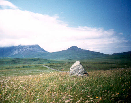
Beinn na Cailleach, Broadford, Skye

Sacred Mountain:  OS Grid Reference – NG 601 232

Getting Here

Seems rather daft giving directions for a mountain, but… For incomers, cross the bridge onto the island and keep on the A87 road to Broadford.  A couple of mile the other side of the village westwards, take the small left turn in the trees and go to the dead-end.  The hill reaching up above you (west) is the legendary mountain to walk up!

Folklore

Beinn na Cailleach

This giant old mountain has been associated with the primal female creation figure, the cailleach, for many a moon. And strangely – for me anyway – I’ve not ventured to sleep with this old place in my passings here as I usually do wherever the cailleach resides.

It doubtless has many more tales than the one A.A. MacGregor (1937) mentions in his superb Peat-Fire Flame.  Here he tells the story of,

“the cairn situated on the summit of Beinn na Cailleach, not far from Broadford… This cairn is believed to mark the site of burial of a Norse princess who died at Ord. On her deathbed this princess commanded her attendants to convey her, when dead to the top of Beinn na Cailleach, and to bury her there, in order that she might lie in the wake of the winds from Norway.”

MacGregor then follows the tale with a lovely note on some boring old dood he obviously had little respect for, saying:

“It is the traditions associated with this cairn that MacCulloch, the geologist, in his Description of the Western Isles of Scotland, asks to be excused from repeating, since he considers them, one and all, to be unworthy of regard. But, then, MacCulloch was a most tiresome fellow; and he seems to have imbued most of his writings with something of the same tiresomeness”!

On the lower northeastern slopes of this great mountain we find another of the old woman’s abodes, the ‘Lochain Beinn na Cailleach’, where this great hag would no doubt wash her linen, as many old myths tell she did at other pools of the same name.

A slightly different version of the folktale was told by Archibald Geikie in his Note-book of a Field Geologist from 1858:

“The top of Beinn na Cailleaich is flat and smooth, surmounted in the centre by a cairn. Tradition tells that beneath these stones there rest the bones of the nurse of a Norwegian princess. She had accompanied her mistress to “the misty hills of Skye,” and eventually died there. But the love of home continued strong with her to the end, for it was her last request that she might be buried on the top of Beinn na Cailleaich, that the clear northern breezes, coming fresh from the land of her childhood, might blow over her grave.”

An early essay in the Gentleman’s Magazine in 1841 tells the grave atop of the mountain to have been the resting place of the Norwegian King Haco’s wife or his nurse. Derek Cooper (1970) meanwhile told us that whilst the cairn was “erected as a memorial to a Skye chieftain,” the cailleach of the mountain, or “the old woman is reputedly Saucy Mary, who laid a chain between Kyle and Kyleakin to exact toll from passing ships.”

There are other mythic place-names scattered around the edges of this mountain with hints of ancient female deities, or pagan goddesses — whichever way one cares to see them.

References:

  1. Cooper, Roy, Skye, Routledge: London 1970.
  2. Geikie, Archibald, The Story of a Boulder, MacMillan: London 1858.
  3. MacGregor, Alisdair Alpin, The Peat-Fire Flame: Folk-Tales and Traditions of the Highlands and Islands, Ettrick Press: Edinburgh 1937.
  4. o’ Crualaoich, Gearoid, The Book of the Cailleach, Cork University Press 2003.
  5. Swire, Otta F., Skye: The Island and its Legends, Blackie & Sons: London 1961.

© Paul BennettThe Northern Antiquarian


Arnabost, Coll, Argyll

Souterrain (destroyed):  OS Grid Reference – NM 2096 6003

Archaeology & History

In Betty MacDougall’s (1966) short work on this history of the island she describes the finding and subsequent destruction of these fascinating underground prehistoric ‘houses’ (as some have called them), telling:

“The vestigial remains of an ‘earth house’, a subterranean dwelling, were uncovered here about 1856 when the road was being made.  The entrance was to the north of the road, under a now empty schoolhouse, and the passage stretched south-eastwards under the road, emerging into a roughly circular chamber, now laid bare in a gravel pit.”

References:

  1. MacDougall, Betty, Isle of Coll, John Miller: Glasgow 1966.
  2. Ritchie, Graham, “Early Settlement in Argyll,” in The Archaeology of Argyll, Edinburgh University Press 1997.
  3. Royal Commission on the Ancient & Historical Monuments, Scotland, Argyll – volume 3: Mull, Tiree, Coll and Northern Argyll, HMSO: Edinburgh 1980.
  4. Wainwright, F.T., The Souterrains of Southern Pictland, RKP: London 1963.

© Paul Bennett, The Northern Antiquarian


Tobar Mor, Tarbert, Gigha, Argyll

Sacred Well:  OS Grid Reference – NR 6564 5190

Also Known as:

  1. Canmore ID 38609
  2. Great Well of the Winds
  3. St Beathag’s Well
  4. Tobar Bheathaig

Folklore

There are a number of sacred and healing wells on this small island, but this site in particular was deemed magickal by folk from far and wide.  Found on the northwest slopes of Cnoc Largie (around which are other heathen spots) this legendary site had an attendant keeper of the well:

“an aged female direach, or guardian, whose uncanny powers could be commanded by a small offering of silver.  Following this the cover of the sacred well would be removed in order that its waters might be ceremonially cleansed with a white clamshell prior to being stirred three times, sunwise, to the accompaniment of ritual incantations.  Then three shell-fulls of the sacred water would be hurled aloft in the direction of the desired wind which, before the day was out, invariably appeared.”

This simple ritual obviously tells that it was a heathen site, seemingly one for divination and magick.  Another piece of folklore (found at other wells) told that if the cover on the well were left unattended, its waters could overflow and flood the entire island.

References:

  1. Anonymous, Exploring Historic Kintyre and the Isle of Gigha, Harlequin Press: Oban n.d.

© Paul Bennett, The Northern Antiquarian

Ardfernal, Jura, Argyll

Standing Stone:  OS Grid Reference – NR 56009 71718

Also Known as:

  1. Canmore ID 38262

Getting Here

Go up Jura’s only road until it becomes a dirt-track and head along the track to the east to the natural hillock on the coast.  You’ll pass the three standing stones of Knockrome before you get to this one, right by the end house.

Archaeology & History

Found in a beautiful setting, this is a thick little stone but is less than four feet tall and it may have had some shapely relationship with one of the hills (Corra Bheinn) on Jura.  The Royal Commission (1984) described it merely as, “an erratic boulder measuring 3.1m in girth at the base, and 1.2m in height with its longer axis aligned roughly east and west.”  Several other stones can be found nearby.

References:

  1. Royal Commission on the Ancient & Historical Monuments of Scotland, Argyll – volume 5: Islay, Jura, Colonsay and Oronsay, HMSO: Edinburgh 1984.

© Paul Bennett, The Northern Antiquarian


Druimyeonbeg, Isle of Gigha, Argyll

Cist (destroyed):  OS Grid Reference – NR 6463 4958

Also Known as:

  1. Canmore ID 38525

Archaeology & History

An old stone-lined burial cist could once be seen in this locale: reported in 1953 to have been “discovered in the southwest corner of a field south of Druimyeonbeg farmhouse.”  When it was uncovered by the farmer, the covering capstone was missing.  Any relics that may have been there were destroyed and there’s now no trace of anything.

References:

  1. Royal Commission on the Ancient & Historical Monuments of Scotland, Argyll – Volume 1: Kintyre, Glasgow 1971.

© Paul Bennett, The Northern Antiquarian