Holy Well, Baildon, West Yorkshire

Holy Well (destroyed):  OS Grid Reference – SE 1609 3961

Archaeology & History

This site is all but unknown to the great majority of folk in Baildon, and even some of the local historians have let it slip from their investigative tendrils.  According to the primary Baildon historian, W.Paley Baildon, it was first known as the ‘Halliwell Holy Well’.  In his magnum opus (1913-26) of the township he relates that,

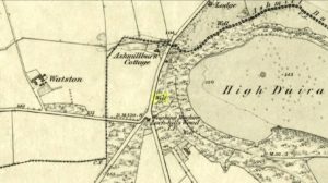
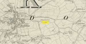
“The 1852 Ordnance map marks Halliway Banks Wood to the south of Langley Lane, with a well just below it, and a footpath from Holden Lane to the well.  Halliway, I think, is a corruption of Halliwell, the ‘holy well,’ with the special footpath leading to it and nowhere else.  Haliwell Bank occurs in (the Baildon Court Rolls of) 1490, when it formed part of the property held by William Tong of Nicolas Fitz William.”

This etymology is echoed by the great place-name authority A.H. Smith (1954).  It also caught the attention of archaeologist Andrea Smith (1982), in her investigation of twenty-five holy wells in the West Yorkshire region.

“Many wells,” she wrote, “are recorded simply as ‘Holy Well,’ or the various forms ‘Halliwell,’ ‘Helliwell’ and ‘Hollowell.’  It is possible that in these instances the identity of the patron saint or guardian of the well has been forgotten, which may be the case with the site at Collingham, now known as Hollowell.”

Site of the Holy Well in 1852

The well itself can no longer be seen.  When I looked for the site in 1982, I found that to the right of where the 1852 map showed it, was a waterworks lid covering the old holy waters, just in the trees atop of the field beneath a great sycamore with a number of small stones roughly encircling the site: perhaps the only possible relics of the century before when the waters would have been used.  A stone trough was situated at the bottom of Holden Lane, fed by the waters from the Halliwell and from here the course of the stream meandered down the side of Slaughter Lane, now known as Kirklands Road.  The land around Halliwell became known as Kirkfield, or field of worship.

A local resident told how during autumn and winter, the left side of the field gets extremely boggy – the region were the old stream ran from the old well, along which dowsers have found aquastats abound.  Now however, houses have been built where the waterworks-lid used to be and is likely to be in someone’s backyard, all but forgotten.

Folklore

According to local lore, the site of this most ancient of holy wells was found in the warmest place in the Baildon district.  Whilst its geographical position doesn’t necessarily suggest this (although it did face south, into the sun), this lore may reflect some healing aspect of the well that has long since been forgotten.

Perhaps relevant to Andrea Smith’s comment about there being ‘guardians’ at holy wells is found in folklore relating to nearby Holden Lane: locals in the last century also referred to it as Boggart Lane, so called after the Boggart which was seen there in the form of a spectral hound that was said to possess large glowing red eyes and was a sign of ill omen.  Modern sightings of the spectral hound, which appeared along the road which led to the old well, are unknown.

References:

  1. Baildon, W. Paley, Baildon and the Baildons (parts 1-15), St. Catherines: Adelphi 1913-26.
  2. Smith, A.H., English Place-Name Elements – volume 1, Cambridge University Press 1954.
  3. Smith, Andrea, ‘Holy Wells Around Leeds, Bradford & Pontefract,’ in Wakefield Historical Journal 9, 1982.

© Paul BennettThe Northern Antiquarian


Holy Well, Barking, Essex

Holy Well (destroyed):  OS Grid Reference – TQ 4421 8484

Archaeology & History

Barely 200 yards to the immediate southeastern edge of the once gigantic hillfort of Uphall Camp, could once be found an old holy well, last recorded it would seem in 1456.  The site was located just yards to the south of the old boundary that separates the parishes of Ilford and Dagenham.  Its location was described in the Victoria County History:

“A mile south of Ilford Bridge the Roding is joined by Loxford Water, a stream rising near Hog Hill, in Dagenham, and known in its upper reaches as Seven Kings Water. In 1456 the lower part of the stream was called Halywellbrooke.”

We also have an account in the Barking Abbey Rental, which told us there was “land in Longland at Halywellbrooke”, as well as “pasture lying at the northern head of Luzias land…near Halywell and…at Loxfordbrigge.” (Harte 2008)  It has long since been destroyed.

References:

  1. Harte, Jeremy, English Holy Wells – volume 2, Heart of Albion Press: Marlborough 2008.
  2. Powell, W.R. (ed.), A Victoria County History of Essex – volume 5, OUP: London 1966.

LinksHoly Well, Barking on The Megalithic Portal


Cloven Hoof Well, Shipley Glen, West Yorkshire

Sacred Well:  OS Grid Reference – SE 12839 39331

Also Known as:

  1. Raygate Well

Getting Here

Cloven Hoof Well, Shipley Glen

On the roadside at Shipley Glen, from Brackenhall Circle walk up for about 250 yards, where you’ll notice the land dips as it drops into the woods below. Follow this dried stream down until you reach the mossy Loadpit Beck in the valley.  By the waterside is a footpath: follow this upstream for a short distance, keeping your eyes peeled on the Earth below where a smaller stream crosses the path you’re walking on.  Follow this uphill to its source!

Archaeology & History

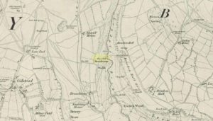
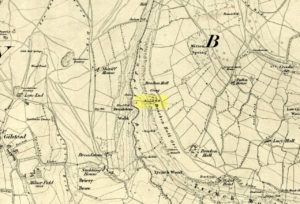
Halfway up (or down) the moss-covered waters of Shipley Glen the all-but-forgotten waters of the Cloven Hoof Well still flows nice and freely, and is still good to drink. It was shown on the first OS-map of the area in 1852, where it was called the Raygate Well, whose derivation neither the great Baildon historian W. Paley Baildon nor the place-name giant A.H. Smith could account for.  It sounds just like it was someone’s surname, but local genealogy cannot affirm this.  One possibility—and which reflects in the local lore of the site—is that it’s a compound word from the old northern dialect word Rea, “an evil spirit or demon”, and gate, “a hole, an opening or gap.”  The terms are used in a prayer given in Mr Sinclair’s Satan’s Invisible World Displayed (1814),

“as recited in the time of Popery by persons when going to bed, as a means of them being preserved from danger:

“Keep this house from the weir…
And from an ill Rea,
That be the gate can gae.””

But this purely speculative….

Cloven Hoof Well on 1852 map

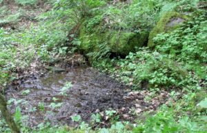
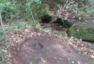
A photograph and brief description of the Cloven Hoof Well was given in an early edition of the Bradford Scientific Journal after a geological excursion to Shipley, though nothing was said of its curious name. However on a rock below the spring, a hoof-print mark is clearly seen.  It appears to be part-natural and partly enhanced.  This is an area rich in prehistoric petroglyphs, or cup and rings stones.

Mosses thankfully still cover the rocks from whence the waters flow; and bilberry, blackberry, male fern and bracken also grow around it.  Psychoactive plants also abound nearby. The water is healthy and never seems to dry up, even during long warm summers.  And below here, on the other side of the stream at the bottom, you can visit the little-known Wood Well

Folklore

Local lore told that the devil stepped here and left his hoof-mark in the rock, making the waters rise from the Earth.  Possibly a venerated site in earlier days, one finds numerous ancient remains nearby (cup and rings, stone circle, walling, cairn fields).  Pagans amongst you should love this place!

References:

  1. Armitage, Paul, The Holy Wells and Healing Springs of West Yorkshire, forthcoming
  2. Baildon, W. Paley, Baildon and the Baildons (parts 1-15), St. Catherines: Adelphi 1913-26.
  3. la Page, John, The Story of Baildon, William Byles: London 1951.

© Paul BennettThe Northern Antiquarian


Katie Thirsty’s Well, Logie, Stirlingshire

Sacred Well:  OS Grid Reference – NS 81787 97653

Getting Here

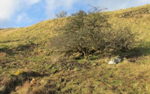
The scraggy hawthorn of Katie Thirsty’s Well

Not too tricky to locate, as long as you get onto the right footpath!  Take either road (both steep narrow and very bendy in places!) up from Logie on one side or Bridge of Allan on the other, towards Sheriffmuir and head to the Faerie or Highlandman’s Well.  About 150 yards before this, note the small car-park.  From here, go through the gate as if you’re walking to Dumyat, but 50 yards along the footpath it splits into two.  Take the lower right-hand path and keep walking for another 600 yards until you see a large worn hawthorn tree on your left, with boggy land just in front of it that runs to the path you’re walking on.  That’s it!

Archaeology & History

‘Katie Thirsty’ is a most intriguing character who pops up at a number of healing wells, primarily in Scotland.  Dedications to her are known near Abernethy, Falkirk, Innerleithen, Killearn, Kilsyth and elsewhere, with one example just over the Scottish border in Northumberland.  So who was she? And what’s the story behind this little known example, close to the ruinous Iron Age village east of Dumyat?  The truth is, we don’t know for sure as yet.  Tales are told of a local lady called ‘Katie’ at the wells near Abernethy and Kilsyth, each with their own domestic myth—but it seems that a wider mythic status underlies this dedication.

One very fine notion comes from the pen of Pictish researcher Ronald Henderson (2008; 2014), who tells that the name derives from a corruption of both St. Katherine of Alexandria [Katie] and the Pictish King, Drust or Drustan [Thirsty].  The latter etymological postulation finds faith in the fact that the great crags of Dumyat less than a mile to the east is universally credited with being the last Pictish stronghold at the old hillfort there.

The flowing clear waters

…This well on the hills north of Logie village—with its old hawthorn for companion above the old path to medieval Fossachie village—flows nicely, and its freezing waters are very good to drink.  Twenty yards east of the boggy overflow are the overgrown remains of an isolated Iron Age ‘homestead’ or hut circle, and the waters of Katie Thirsty’s Well would have been the primary drinking supply to the people living there in ancient times.

Very little is known about the specific history or folklore of the site and it is mentioned only in passing by David Morris (1935) who told us simply:

‘“Katie Thirty’s Well’ was the old name of a clear spring on the hillside by the track leading to Dumyat.”

It’s a beautiful spot to visit, with lovely views for many miles to the east, south and west.  If you’re going to visit the Fairy or Highlandman’s Well nearby, take time to visit Katie Thirsty’s refreshing flow too.

As for Katie herself: does anyone have their own ideas about her…?

References:

  1. Henderson, Ronald W., Rex Pictorum – The History of the Kings of the Picts, Perth 2008.
  2. Henderson, Ronald W., “Drust… of the Hundred Battles,” in Celtic Guide, 3:4, April 2014.
  3. Morris, David B., “Causewayhead a Hundred Years Ago,” in Stirling Natural History & Archaeological Society Transactions, 1935.

© Paul BennettThe Northern Antiquarian

St. Peter’s Well (2), Leeds, West Yorkshire

Holy Well (destroyed):  OS Grid Reference – SE 308 336

Archaeology & History

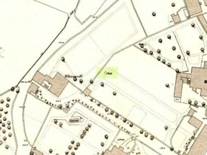
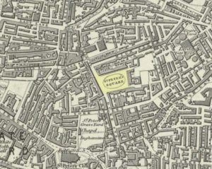
St Peters Well locale in 1852

This is one of three wells that were dedicated to St Peter in the Leeds district.  The first of them, near the city centre, was described by the northern antiquarian Ralph Thoresby (1715) as being in St. Peter’s Square—which has now been completely built over, but was situated “at the bottom or west end of High Street,” (Bonser 1974) about 50 yards west of the modern Quarry Hill buildings.  It was well known in the area in early times with a good curative reputation due seemingly to its sulphur content.  Mr Thoresby told that us, it

“is intensely cold and very beneficial for such as are afflicted with rheumatic pains, or weakness, rickets, etc, for which reason it is much frequented by such, who might otherwise have recourse to St. Mungus or Mongah, as it is more truly writ. This Spring, according to St Anselms Canon, which forbad a credulous attributing any reverence, or opinion of holiness to fountains…must either have been of great antiquity, or have had the bishop’s authority.”

Local folk of course, would have long known the goodness of this water supply long before any crude bishop.  The well either possessed a very large stone trough or it had been fashioned and added to by locals, as Thoresby reported “trying the cold bathing of St Peter’s.”  He took his youngest child there, Richard, to help him overcome an osteopathic ailment.  In his diary entry for April 8, 1709, he wrote:

“Was late at church, and fetched out by a messuage from the bone-setter (Smith, of Ardsley), who positively affirms that one part of the kneebone of my dear child Richard, has slipped out of its proper place; he set it right and bound it up; the Lord give a blessing to all endeavours!  We had made use of several before, who all affirmed that no bone was wrong, but that his limp proceeded rather from some weakness, which we were the rather induced to believe, because warm weather, and bathing in St. Peter’s Well, had set him perfectly on his feet without the least halting, only this severe Winter has made him worse than ever.”

It later became at least one of the water supplies for Maude’s Spa close by.  As usual with health-giving waters at this period in the evolving cities, money was to be made from them and local folk had to find their supplies from other sources.  St Peter’s Sulphur Baths (as it was called) were built on top of it in the 19th century and, said Bonser “flourished until the early years of the (20th) century.”

Although I can find no notices of annual celebrations or folklore here, St. Peter’s Day is June 29 — perhaps a late summer solstice site, though perhaps not.

It would be good if Leeds city council would at least put historical plaques in and around the city to inform people of the location of the many healing and holy wells that were once an integral part of the regions early history.  Tourists of various interest groups (from christian to pagan and beyond) would love to know more about their old sacred sites and spend their money in the city.

References:

  1. Atkinson, D.H., Ralph Thoresby, the Topographer – volume 1, Walker & Laycock: Leeds 1885.
  2. Baines, Edward, The Leeds Guide, E.Baines: Leeds 1806.
  3. Bonser, K.J., “Spas, Wells and Springs of Leeds,” in Publications Thoresby Society, 54:1, 1974.
  4. Harte, Jeremy, English Holy Wells – volume 2, Heart of Albion: Wymeswold 2008.
  5. NiBride, Feorag, The Wells and Springs of Leeds, Pagan Pratlle: Leeds 1994.
  6. Robinson, Percy, Relics of Old Leeds, P.Robinson: Leeds 1896.
  7. Smith, Andrea, ‘Holy Wells Around Leeds, Bradford & Pontefract,’ in Wakefield Historical Journal 9, 1982.
  8. Thoresby, Ralph, Ducatus Leodiensis, Maurice Atkins: London 1715.
  9. Whelan, Edna & Taylor, Ian, Yorkshire Holy Wells and Sacred Springs, Northern Lights 1989.

© Paul BennettThe Northern Antiquarian

Ffynnon Rufeinig, Llandudno, Caernarvonshire

Healing Well:  OS Grid Reference – SH 76551 83858

Also Known as: 

  1. Ffynnon Llety Fadoc
  2. Roman Well

Archaeology & History

Ffynnon Rufeinig, 1901 OS-map

To be found on the legend-filled landscape known as the ‘Great Orme’, this ancient well was highlighted on the 1901 OS-map of the region, on the south side of the track.  Sadly,  despite an occasional puddle that fills the old trough when She rains, its waters are no longer running.  H.C. Jones (n.d.) informed us that this was a ‘Roman Well’, which tradition said was a place they used when they invaded this part of Wales, although Paul Davies (2003) thought this “to be wishful thinking”.

Despite this, in recent years the walling around the well has been rebuilt by the track-side and a stone plaque with the words ‘Roman Well’ has been mounted to tell you that you’re at the right place.

References:

  1. Davies, Paul, Sacred Springs, Blorenge: Llanfoist 2003.
  2. Jones, H. Clayton, “Welsh Place-Names in Llandudno and District” in Mountain Skylines and Place-Names in Llandudno and District, Modern Etchings: Llandudno n.d. (c.1950)

© Paul BennettThe Northern Antiquarian


Cunnel Fold Well, Marsett, Bainbridge, North Yorkshire

Healing Well:  OS Grid Reference – SD 88727 85543

Archaeology & History

Cunnel Fold Well on 1856 map

Found high on the moors several miles south of Hawes, this is a small almost insignificant water source that I sat with, drinking in both the landscape and the waters many moons ago in a daydreaming amble.  It’s history is only remembered in the name it was given, no doubt by some local to the Ordnance Survey lads in their own, albeit more focussed assessment on these hills.  Its name puzzled me for a long while and I wondered if some untold story lay behind it.  Sadly that doesn’t appear to be the case.  Although there are doubtless many tales that could be told of the people who, through the centuries, have sat and drank the waters here, we know none.

Its name very probably derives from the misapprehended dialect word ‘cannel’ which, as Mr Wright (1898) explains, is simply “a ditch…gutter, watercourse,” which seems appropriate here.  Of the place-names shown on the 1856 OS-map, it seems the most likely solution to the word.

As for a place to sit and have a drink, it’s very refreshing after the rains have fallen.  All too often nowadays, as with many of the old hilltop watercourses, their life-blood is falling back to Earth…

References:

  1. Wright, Thomas (ed.), English Dialect Dictionary – volume 1, Henry Frowde: London 1898.

© Paul BennettThe Northern Antiquarian


Tun Well, Eccleshill, Bradford, West Yorkshire

Healing Well:  OS Grid Reference – SE 1822 3593

Also Known as:

  1. Tunny Well

Archaeology & History

Tun Well, on 1893 map

First mentioned in local history accounts from 1618—as the Tunwells—it was highlighted on the first OS-map of Eccleshill in 1851.  Located on the aptly-named Tunwell Lane, it was a deep well covered by a large flat slab of stone, at the back-end the old Victorian mill.  The stone was put there to prevent children falling into it.  Some old locals thought the name of the place derived from a ‘tun’, or hundred, meaning it to be a hundred feet deep; although as A.H. Smith (1961) tells, tun could equally relate it to be one of Eccleshill’s town wells, of which there were several.  It used to be one of the principal drinking supplies for the village and was said to rarely run dry.  In William Ranger’s (1854) survey, he told this to be one of the sites to which local people relied in times of drought, where the land-owner allowed local folk to collect their supplies.

Folklore

The old cobbled Tunwell Lane was long ago supposed to be the haunt of a phantom black dog: a visionary precursor of death and Underworld guardian. Its spirit came and went into the deep well.  I remember hearing tales of this when I was a young lad, as the old women who worked in the adjacent mills spoke of it.  The ghost of a so-called ‘white lady’ was also said to walk along Tunwell Lane.

In more recent times, Val Shepherd (2002) included this in her short survey of wells in the area as being on “an alignment” with Eccleshill’s Moor Well and Holy Well.  She thought “it may be part of a ley line”, but her alignment is inaccurate and doesn’t hit the spots.

References:

  1. Crapp, H.C. & Whitehead, Thomas, History of the Congregational Church at Eccleshill, Watmoughs: Idle 1938.
  2. Ranger, William, Report to the General Board of Health on a Preliminary Inquiry into the Sewerage, Drainage, and Supply of Water, and the Sanitary Condition of the Inhabitants of the Township of Eccleshill, George Eyre: London 1854.
  3. Shepherd, Val, Holy Wells of West Yorkshire and the Dales, Lepus: Bradford 2002.
  4. Smith, A.H., The Place-Names of the West Riding of Yorkshire – volume 3, Cambridge University Press 1961.

© Paul BennettThe Northern Antiquarian


Swithins Well, Rothwell, West Yorkshire

Healing Well (destroyed):  OS Grid Reference – SE 3442 2686

Also Known as:

  1. St. Swithin’s Well

Archaeology & History

Swithins Well on 1854 map

Highlighted in the fields on the south-side of Rothwell village on the 1854 OS-map, Swithin’s Well was, according to historian Andrea Smith (1982), previously known as a holy well, dedicated to the obscure Saxon saint of the same name.  Although no ‘well’ relating to St Swithin comes from any early texts, the field and farmhouse of ‘Swithins’ were cited in records from the Cartulary of Nostell Priory in 1270 CE; then subsequently in a variety of records throughout the 14th, 15th and 16th centuries.  According to Miss Smith (1982),

“The first recording of St Swithin’s Well, Rothwell…was on an estate map of 1792 (‘Plan of St. Clement’s lands in the parish of Rothwell in the County of York, two-third part of the tithes of corn and grain of which belong to the King in right of His Ducky of Lancaster’, PB), and the field-names arising from it—Swithin’s, Swithin’s Barn, Swithin’s Lane Close—serve to give an indication of the well’s past importance as a local landmark.”

When she visited the site around 1980, she reported finding,

“several wet patches running in a line westwards downhill, but the farmer’s wife seemed certain that this was a broken drain and nothing else could be seen in that field or neighbouring ones, which could have been the well.”

Very recently, the Wakefield pagan and antiquarian Steve Jones went to see if the well or any remains of it could still be seen and told us:

“We went looking for the well down a footpath but it was obviously filled in when a colliery was nearby in the early 20th century and (there is) no trace of any spring now.”

Another one’s bitten the dust, as they say…..

But we must note that the grand place-name authority, A.H. Smith (1962) found no references to St. Swithin here and instead suggested the name derived from the old Norse word, sviðinn, ‘land cleared by burning’, which is echoed in the old local dialect word swithen, ‘moorland cleared by burning’ (Smith 1956), and similarly echoed in Joseph Wright’s (1905) magnum opus, where—along with meaning ‘crooked, warped’—it means “to burn, superficially, as heather, wool, etc.”   There is also a complete lack of any mention to the saintly aspects of this place in John Batty’s (1877) primary history book on Rothwell parish, and yet he cites numerous other springs and wells in the region that have fallen out of history.

References:

  1. Batty, John, The History of Rothwell, privately printed: Rothwell 1877.
  2. Jones, Steve, Personal communication, Facebook 27.08.2018.
  3. Rattue, James, “The Wells of St Swithun,” in Source, Summer 1995.
  4. Smith, Andrea, “Holy Wells Around Leeds, Bradford & Pontefract,” in Wakefield Historical Journal 9, 1982.
  5. Smith, A.H., The Place-Names of the West Riding of Yorkshire – volume 2, Cambridge University Press 1961.
  6. Smith, A.H., English Place-Name Elements – volume 2, Cambridge University Press 1956.
  7. Wright, Joseph, English Dialect Dictionary – volume 5, Henry Frowde: Oxford 1905.

Acknowledgements:  Many thanks to Steve Jones of Wakefield for his informing us about the status of this site.

© Paul BennettThe Northern Antiquarian


St. Patrick’s Well (1), Dunruchan, Muthill, Perthshire

Holy Well:  OS Grid Reference – NN 77905 17365

Getting Here

St Patricks Well on 1863 map

Take the B827 road between Comrie and Braco. If you’re coming via Comrie, going uphill for 3.1 miles (5.1km); but if from Braco Roman Camp go along and eventually downhill for 6.6 miles (10.6km), watching out for the track to Middleton Farm by the roadside.  Walk along for 125 yards, keeping your eyes peeled for the boggy ground below on your left. You’re there!

Archaeology & History

Immediately east of the prodigious megalithic complex of Dunruchan, bubbling up amidst the usual Juncus conglomeratus reeds, are the boggy remnants of St. Patrick’s Well—one of two such sacred wells dedicated to the early Irish saint in Muthill parish. We’re at a loss as to why this Irish dood has such sites in his name in this area.  No doubt some transitional shamanic character was doing the rounds in this glorious landscape, muttering words of some neo-christian animism, eventually settling a mile from the great megalithic complex, perhaps hoping—and failing—to convert our healthy heathen populace into ways unwise.

The shallow boggy waters
The site of St Patricks Well

Whatever he may have been up to, a small stone chapel was built hereby and, it was said, even a christian graveyard, to tempt folk away from the ancient plain of cairns whence our ancestors had long since buried their dead.  But the christian’s chapel and graveyard has long since gone; and when historians before me had visited the place, St Patrick’s Well had also fallen back to Earth in the drier summers, taking the blood of the Earth back into Her body.  The heathen megaliths still remain however, standing proud on the moorland plain in clear sight from these once healing waters, whose mythic history, on the whole, has long since been disregarded….

Folklore

St Patrick’s day on March 17—”a date very near the Spring Equinox,” as Mrs Banks (1939) reminded us—may have been the dates when the waters here were deemed particularly efficacious, although we have nothing in written accounts to tell us for sure. But in the 19th century Statistical Account we find that the site was “much frequented once, as effectual in curing the hooping cough.”  E.J. Guthrie (1885) told of an ancient rite regarding the drinking of the waters for effect of the cure, saying:

“In the course of this century a family came from Edinburgh, a distance of nearly sixty miles, to have the benefit of the well. The water must be drunk before sunrise or immediately after it sets and that out of a “quick cow’s horn”, or a horn taken from a live cow, and probably dedicated to this saint.”

Also in Muthill parish, Guthrie told, St Patrick’s memory was held in such veneration that farmers and millers did not work on his day.

References:

  1. Banks, M. MacLeod, British Calendar Customs: Scotland – volume 2, Folk-lore Society: Glasgow 1939.
  2. Booth, C. Gordon, “St Patrick’s Well (Muthill Parish),” in Discovery & Excavation, Scotland, New Series volume 1, 2000.
  3. Guthrie, E.J., Old Scottish Customs, Thomas D. Morison: Glasgow 1885.
  4. MacKinlay, James M., Folklore of Scottish Lochs and Springs, William Hodge: Glasgow 1893.
  5. Morris, Ruth & Frank, Scottish Healing Wells, Alethea: Sandy 1982.

© Paul BennettThe Northern Antiquarian